David Middlecamp

21.9K posts

David Middlecamp banner
David Middlecamp

David Middlecamp

@DavidMiddlecamp

Photographer at the Tribune in San Luis Obispo. Writing about Central Coast history at Photos From the Vault. Same handle on Blue Sky.


San Luis Obispo, CA Katılım Ekim 2012
860 Takip Edilen1.6K Takipçiler
David Middlecamp retweetledi
NWS Los Angeles
NWS Los Angeles@NWSLosAngeles·
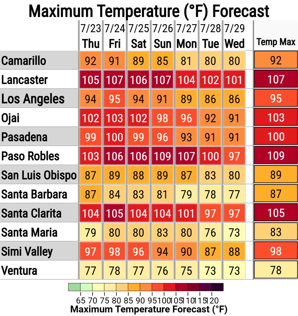
While many areas are seeing minimal warming today, everything remains on track for a sharp warmup tomorrow. It will continue to feel muggy. Nights remain warm. Do not under-estimate the heat. Stay safe neighbors. #cawx
NWS Los Angeles tweet mediaNWS Los Angeles tweet media
English
2
30
103
9.6K
David Middlecamp retweetledi
Jason D Farhang
Jason D Farhang@jason61987·
Wednesday, July 22, 2026, 6:42 AM PDT: We have our first eastern Pacific hurricane officially hit category 1 strength, and its name is Fausto. He has already started pulling deep tropical moisture northward in the last 24 hours. The main 594 DM high-pressure axis is currently stationary over western Oklahoma, and the northeast portion of New Mexico has begun to expand its peripheral edges towards Southern California and Arizona to set up for southeasterly teleconnection with Fausto and the Monsoonal high axis. This will cause widespread heat index values across all valleys of Central and Southern California to feel like 95F - 114F in the next 5 days. Due to Fausto's larger size than Elida's width, this will cause strong south swells from Pismo Beach to San Diego with wave heights up to 5 ft- 10 ft in the next 72 hours. Strong, aggressive rip currents and possibly some minor coastal flooding from Santa Barbara to San Diego beaches by Saturday morning. If you notice the latest water vapor satellite, you will see the remnants of Elida bring tropical moisture into Oregon and Washington state in the next 24 hours for high confidence of isolated strong to severe thunderstorms that can cause small isolated tornadoes, and very heavy rainfall due to the close proximity of the main center of the low axis, which is a true testament to the intensification of El Niño and the expansive marine heat wave across the central and northern Pacific. This has allowed for tropical systems to maintain some form of their impacts on northward, far-reaching regions. I'm monitoring the latest weather developments in the next 24 - 36 hours. #CAwx #AZwx #PacifcNorthwest #HurricaneSeason2026 #Monsoon #ElNino #Heatwave #Fausto #Elidia
English
11
56
417
23.4K
David Middlecamp retweetledi
John Lindsey
John Lindsey@PGE_John·
A photogenic former Tropical Storm Elida, now centered about 600 miles west of Point Conception, has weakened significantly and transitioned into an extratropical system with an associated cold front. The system is producing southwesterly winds across the Central Coast, along with muggy conditions and warm to hot temperatures. As of this afternoon, my weather station in Los Osos is recording 78°F. Increasing mid- and high-level clouds this evening will help keep overnight temperatures unusually mild. Beginning Wednesday, gale-force afternoon northwesterly winds will develop along the coastline and continue through the remainder of the week. These onshore winds will bring cooler weather to the immediate coast. However, coastal valleys such as San Luis Obispo are expected to continue reaching the mid-80s during the late morning/eraly afternoon, before the cool marine air brings relief later in the afternoon, while inland valleys, including Paso Robles, will soar into triple-digit levels through the remainder of the Mid-State Fair.
Los Osos, CA 🇺🇸 English
0
11
61
2.6K
David Middlecamp retweetledi
CHP Templeton
CHP Templeton@CHP_Templeton·
ROADWAY OPEN  Update: All lanes of SR‑41 at SR‑46E are now OPEN in both directions. Normal traffic flow has resumed. Please use caution while driving through the region, as emergency crews and equipment may still be present along the roadway.
CHP Templeton tweet media
English
0
3
2
330
David Middlecamp retweetledi
CHP San Luis Obispo
TRAFFIC CONTROL ALL DAY on Turri Road between South Bay Blvd and Los Osos Valley Road, 7/17/26 8:30am-9pm, expect major delays all day. Please avoid the area if you do not want to be delayed.
CHP San Luis Obispo tweet media
English
1
2
2
165
David Middlecamp retweetledi
California Geological Survey
California Geological Survey@CAGeoSurvey·
NEW MAP! The brand-new California Geological Survey (CGS) Postfire Debris Flow Potential Map depicts the combined annual probability of wildfire and subsequent debris flow that is triggered by rainfall. conservation.ca.gov/cgs/bwg/prefir…
California Geological Survey tweet media
English
1
19
61
2.6K
David Middlecamp retweetledi
SpaceX
SpaceX@SpaceX·
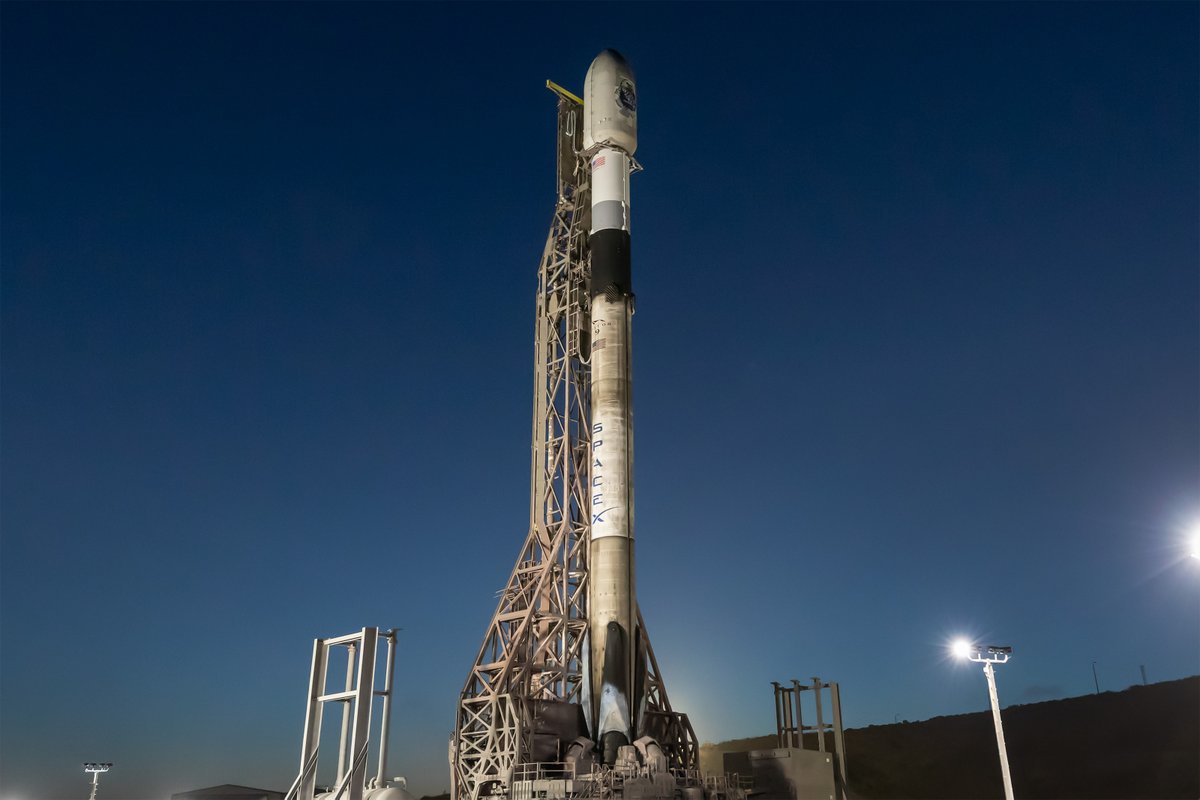
Falcon 9 is vertical at pad 4E in California ahead of today’s launch of the @SemperCitiusSDA's third Tranche 1 data transport mission. Liftoff is targeted for 1:32 p.m. PT → spacex.com/launches/sda-t…
SpaceX tweet media
English
177
586
4.3K
403.2K