Environment Geoinformatics

424 posts

Environment Geoinformatics

Environment Geoinformatics

@EGeoinformatics

Katılım Ocak 2023
45 Takip Edilen50 Takipçiler
Environment Geoinformatics
Environment Geoinformatics@EGeoinformatics·
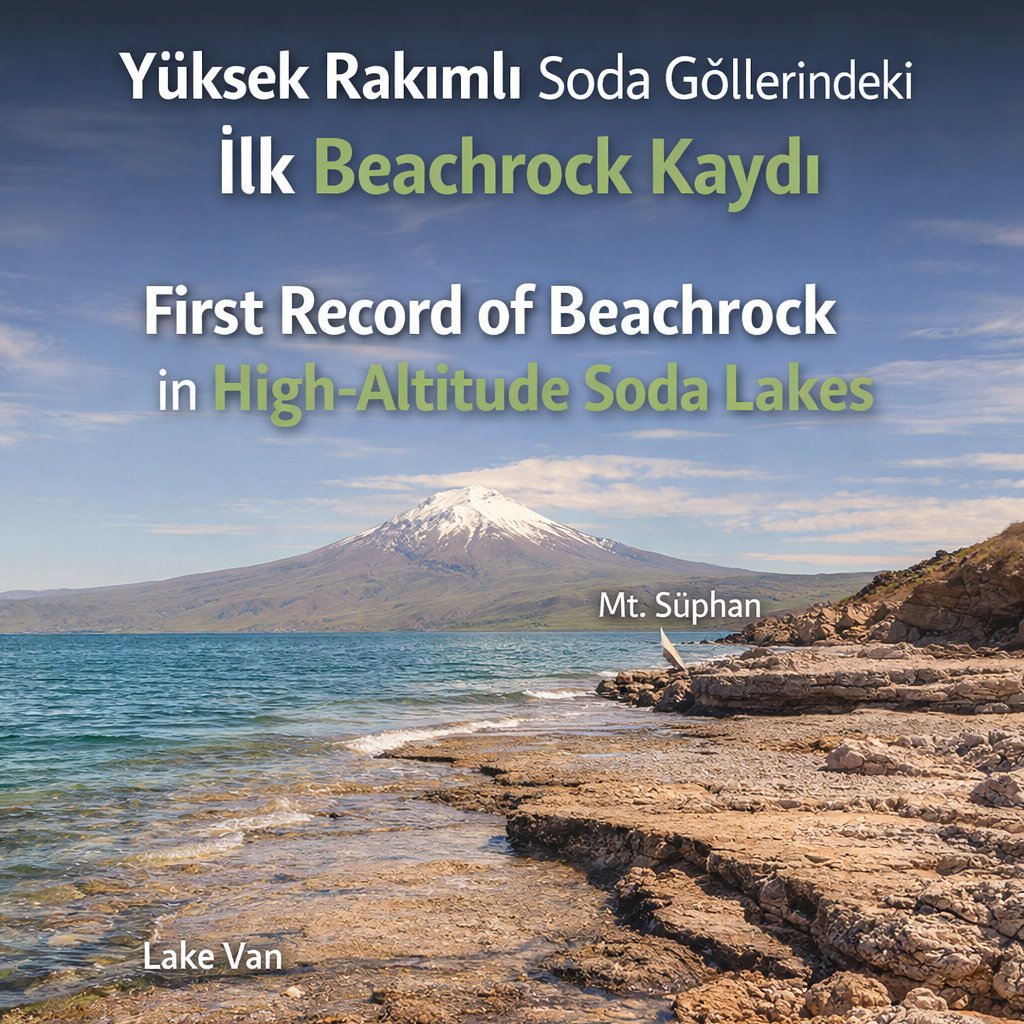
This study along the shores of VanLake reveals, for the 1st time, the formation of beachrock in high-altitude soda lakes. High alkalinity, evaporation, and arid climate conditions enable the natural cementation of sediments, while microbial processes also play a role @iu_debien
Environment Geoinformatics@EGeoinformatics

#vangölü kıyılarındaki bu çalışma, yüksek rakımlı soda göllerinde beachrock oluşumunu ilk kez ortaya koyuyor. Yüksek alkalinite, buharlaşma ve kurak iklim, sedimanların doğal çimentolanmasını sağlarken mikrobiyal süreçler de etkili olduğu ispatlanıyor dergipark.org.tr/en/download/ar…

English
0
1
2
33
Environment Geoinformatics
Environment Geoinformatics@EGeoinformatics·
#vangölü kıyılarındaki bu çalışma, yüksek rakımlı soda göllerinde beachrock oluşumunu ilk kez ortaya koyuyor. Yüksek alkalinite, buharlaşma ve kurak iklim, sedimanların doğal çimentolanmasını sağlarken mikrobiyal süreçler de etkili olduğu ispatlanıyor dergipark.org.tr/en/download/ar…
Environment Geoinformatics tweet media
Türkçe
0
0
1
42
Environment Geoinformatics retweetledi
tarla.io
tarla.io@tarlaio·
🇹🇷Türkiye Yağış Raporu: Kuraklıktan Bolluğa Dönüş! 🌧️ Son 3 aylık Standart Yağış Endeksi (SPI) verileri, Türkiye genelinde su bütçesi açısından oldukça sevindirici bir tabloyu ortaya koyuyor. Geçtiğimiz yılın aynı döneminde yaşadığımız derin yağış açığı, yerini geniş çaplı bir toparlanmaya bıraktı. 📉 Geçmişin İzleri: Nereden Geldik? Trend grafiğine baktığımızda, 2025'in ilk çeyreğinde Türkiye'nin büyük bir bölümünün "Class 0" ve "Class 1" (Siyah ve Kahverengi) yani aşırı ve şiddetli kuraklık etkisinde olduğunu görüyoruz. Geçen yıl Mart ayı başlarında ülkenin %60'ından fazlası yağış açığıyla mücadele ediyordu. 📈 Güncel Durum: Neredeyiz? (Mart 2026) 2026 yılı Mart ayı itibarıyla tablo tamamen tersine dönmüş durumda: %82.21 "İyi" Durumda: Ülke topraklarımızın büyük çoğunluğu SPI değerlerine göre pozitif (yeşil ve mor bölgeler) alanda kalıyor. %17.79 "Ortalama": Mevsim normalleri civarında seyreden bölgelerimiz. %0.00 "Kötü": Haritada kritik seviyede yağış açığı olan (negatif anomali) bölge kalmamış görünüyor. 🗺️ Bölgesel Bakış Haritadaki mor alanlar (SPI > 2.0) yağışların normallerin çok üzerinde gerçekleştiğini gösteriyor. Özellikle Doğu Anadolu, Güneydoğu Anadolu ve İç Anadolu'nun doğusunda su rezervleri ve toprak nemi açısından altın bir dönem yaşanıyor. Ege ve Marmara bölgelerinde ise "normal ve üzeri" (açık yeşil) seyir devam ediyor. 💡 Özetle: Geçen seneki tarımsal kuraklık riskinin aksine, bu yıl 3 aylık kümülatif yağışlar yer altı su kaynakları ve baraj dolulukları için can suyu oldu. #iklim #tarım tarla.io #risk
tarla.io tweet mediatarla.io tweet media
Türkçe
1
13
53
11.9K
Environment Geoinformatics
Environment Geoinformatics@EGeoinformatics·
Urban expansion in Sylhet, Bangladesh has accelerated LULC changes, reducing vegetation and water bodies. Landsat (1989–2024) shows increasing settlements and declining NDVI, revealing a strong link between rapid urbanization and ecosystem degradation link ⬇️
Environment Geoinformatics tweet mediaEnvironment Geoinformatics tweet mediaEnvironment Geoinformatics tweet media
English
1
2
2
168
Environment Geoinformatics retweetledi
Istanbul University, Institute of Marine Sciences
@fuattdursun will participate in the, "Tracking the footprint of an extreme harmful algal bloom event: integrative assessment from open ocean to coastal area approach and its connections to the Atlantic Ocean (CHL-A-HAB)" project.
Istanbul University, Institute of Marine Sciences tweet media
Istanbul University, Institute of Marine Sciences@iu_debien

@fuattdursun 2Nis-6May26 tarihleri arasında R/V METEOR ⬇️ ile "Tracking the footprint of an extreme harmful algal bloom event: integrative assessment from open ocean to coastal area approach and its connections to the Atlantic Ocean (CHL-A-HAB)" adlı projede yer almaktadır.

English
0
5
7
141
Environment Geoinformatics retweetledi
Istanbul University, Institute of Marine Sciences
@fuattdursun 2Nis-6May26 tarihleri arasında R/V METEOR ⬇️ ile "Tracking the footprint of an extreme harmful algal bloom event: integrative assessment from open ocean to coastal area approach and its connections to the Atlantic Ocean (CHL-A-HAB)" adlı projede yer almaktadır.
Istanbul University, Institute of Marine Sciences tweet mediaIstanbul University, Institute of Marine Sciences tweet mediaIstanbul University, Institute of Marine Sciences tweet media
English
1
4
8
353
Environment Geoinformatics retweetledi
Oceana
Oceana@oceana·
Scientists have discovered 24 new deep sea species — and an ENTIRELY NEW branch of life in the Pacific. But the region faces deep-sea mining threats, and this biodiversity could be lost as quickly as it was found. Places like this deserve protection! bit.ly/3PL3xoo
English
7
192
381
5.1K
Environment Geoinformatics retweetledi
GO GREEN
GO GREEN@ECOWARRIORSS·
China and Trump on verge of destroying vast swathes of the last untouched place on Earth The deep sea ocean Ocean life will be obliterated in the deep sea and vast plumes will smother ocean life at top of ocean Will also destroy huge carbon sink news.mongabay.com/custom-story/2…
GO GREEN tweet media
English
10
211
288
3.9K
Environment Geoinformatics
Environment Geoinformatics@EGeoinformatics·
LULC changes in Mymensingh Sadar (2017/23) show urban growth (+96.6%) and significant groundwater decline. Population and water demand increases are key drivers, while farmland decreased. NDVI results indicate vegetation stress and reduced recharge 📧arifemtious010@gmail.com
Environment Geoinformatics tweet media
English
0
0
2
133
Environment Geoinformatics retweetledi
Istanbul University, Institute of Marine Sciences
Almanya Federal Eğitim ve Araştırma Bakanlığı (BMBF) tarafından desteklenen proje adı: "Tracking the footprint of an extreme harmful algal bloom event: integrative assessment from open ocean to coastal area approach and its connections to the Atlantic Ocean (CHL-A-HAB)"
Istanbul University, Institute of Marine Sciences tweet media
Română
0
2
4
110
Environment Geoinformatics retweetledi
Istanbul University, Institute of Marine Sciences
Doç. Dr. Fuat DURSUN @fuattdursun, Alfred Wegener Kutup ve Deniz Araştırmaları Enstitüsü'nün (AWI) yürütücü olduğu bir proje⬇️kapsamında R/V METEOR araştırma gemisi ile 02.04-06.05.26 tarihleri arasında Şili'de Punta Arenas –Talcahuano arasındaki araştırma seferine katılıyor
Istanbul University, Institute of Marine Sciences tweet mediaIstanbul University, Institute of Marine Sciences tweet mediaIstanbul University, Institute of Marine Sciences tweet media
Türkçe
1
4
11
201
Environment Geoinformatics retweetledi
Istanbul University, Institute of Marine Sciences
@fuattdursun yürütücü olduğu Horseshoe Adası Bölgesindeki (B.Antarktika) Potansiyel Zararlı/Toksik Fitoplankton Türlerinin Morfolojik Ve Toksikolojik Karakterizasyonu adlı @Tubitak P. kapsamında @iu_debien adına Beyza Doruk X. ulusal Antarktika seferinde Antarktika'daydı
Istanbul University, Institute of Marine Sciences tweet mediaIstanbul University, Institute of Marine Sciences tweet mediaIstanbul University, Institute of Marine Sciences tweet media
Türkçe
0
3
5
115
Environment Geoinformatics retweetledi
Zeke Hausfather
Zeke Hausfather@hausfath·
El Niño is coming, and it is shaping up to be a big one. Over at The Climate Brink I've put together a compilation of the latest forecasts by different modeling groups. They suggest that we might see an event comparable in strength to what we saw in 2016.
Zeke Hausfather tweet media
English
35
624
1.8K
146.5K