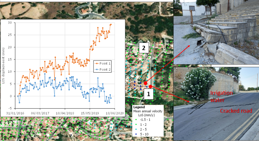
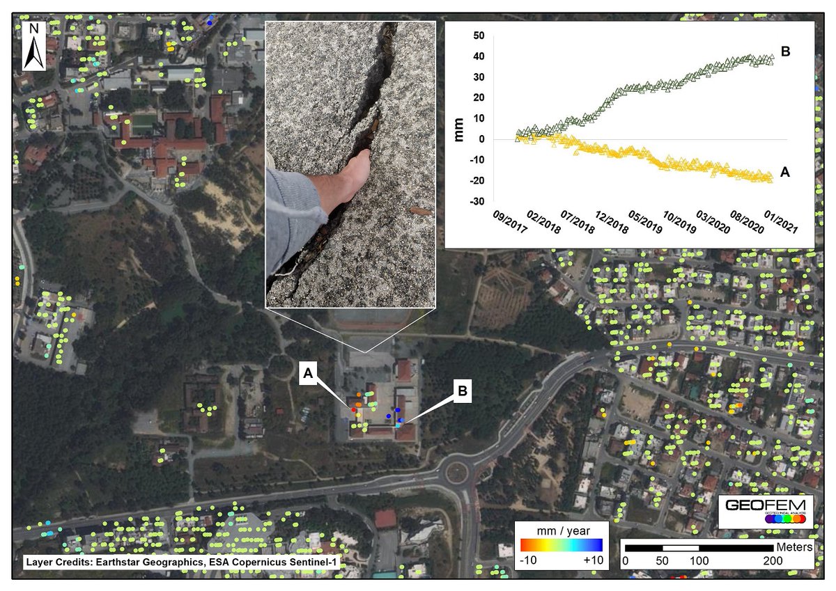
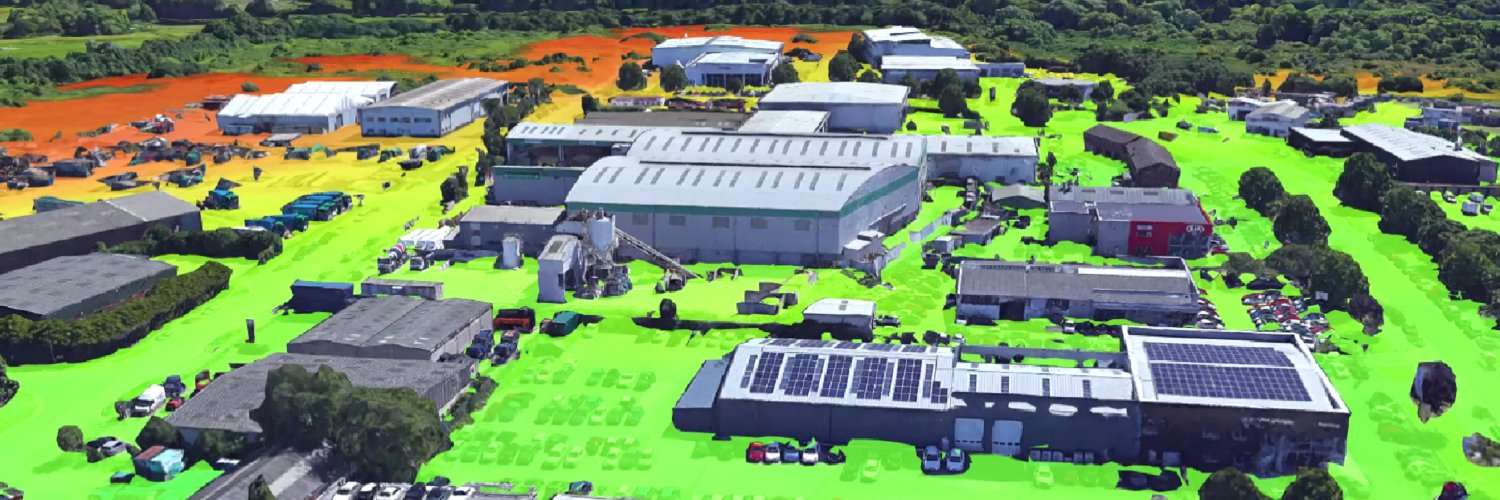
Geofem

113 posts

Geofem banner
Geofem

Geofem

@GeotechFEA

Follow developments in the application of earth observation and GIS technology to infrastructure asset monitoring and civil engineering.

Katılım Ekim 2011
48 Takip Edilen306 Takipçiler
Geofem
Geofem@GeotechFEA·
How can #technology help improve transport 🚆 infrastructure #resilience to geohazards in the face of climate challenge? Hear satellite expert and geotechnical engineer Dr Skevi Perdikou at @GE_magazine Transport Geotechnics 2022 event on 19th May in London.
Geofem tweet media
English
0
1
1
0
Geofem
Geofem@GeotechFEA·
Having satellite images taken at the same local time of day every time reduces variability between images. This helps when analysing a series of images to detect changes over time. It’s one of the reasons why we can measure displacements with millimetric accuracy from space.
GIF
English
0
0
0
0
Geofem
Geofem@GeotechFEA·
IS THAT A FACT? 😲🤯 Yes, SAR #satellites 🛰 for #InSAR analysis mostly operate in a sun-synchronous orbit (SSO). This means that they revisit the same spot at the exact same time of day every time. You could set your watch ⌚ by them (if you could see them)!
English
0
0
1
0
Geofem
Geofem@GeotechFEA·
Read our case study to see how the #SAR #satellite data and #engineering expertise helped the largest integrated resort (IR) in Europe to: 👉Reduce the cost of construction by €300k 👉Reduce time spent on site investigation 👉Reduce the project’s carbon footprint
Geofem tweet media
English
0
1
0
0
Geofem
Geofem@GeotechFEA·
Protecting a 3,000 year old #monument 🏺 with today’s 🛰️ #satellite technology! As part of a #EuropeanSpaceAgency funded project, we installed corner reflectors adjacent to archaeological sites such as Amathous, to optimise monitoring with no disturbance to these precious sites
English
0
0
1
0
Geofem
Geofem@GeotechFEA·
Which #siteinvestigation technique records data before the project even starts? The answer is #satellite #SAR data. It’s being gathered all the time to be converted to surface displacement and soil moisture changes. You can immediately detect site trends 5 years back!
English
0
1
1
0
Geofem
Geofem@GeotechFEA·
‘The construction industry needs 2.2 million more workers to keep up with demand’ (Business Insider, 2021). 9/10 companies experience difficulties filling these positions. With #satellite #SAR #data no workforce is required on site. Monitoring is done by office-based specialists.
English
0
0
0
0
Geofem
Geofem@GeotechFEA·
Productivity in the construction sector has increased only 1% in the last 20 years. Real-time #SAR #satellite #data can help overcome the #productivity hurdle. Data can be obtained free-of-charge, in an instant, every few days, in all weather conditions.
English
0
2
3
0
Geofem
Geofem@GeotechFEA·
The rate of musculoskeletal disorders is very high in the #construction sector (HSE, 2021). Using #satellite #SAR data allows you to monitor large and remote construction sites, without needing to carry equipment, leading contractors a step closer to their zero-harm targets.
English
0
0
0
0
Geofem
Geofem@GeotechFEA·
#SAR #satellites are orbiting 700km above you head, recording data for the entire land surface. You can go back 5 years and detect #displacement trends immediately without needing to wait months to accumulate in situ data. You can also use them for #construction #monitoring.
English
0
0
0
0
Geofem
Geofem@GeotechFEA·
We’re delighted to welcome 3 new recruits to Geofem: Jordan Aloupas as Senior Civil Engineer, Styliana Stavrou as Remote Sensing Geologist and Iphigenia Christophoridou as Office Administrator. It's great to have you all here!
GIF
English
0
0
0
0
Geofem
Geofem@GeotechFEA·
It's confession time at Geofem... We're sorry to say that we weren't keeping our website updated. But we have fixed that now with a website right up to date with our latest services and case studies. Are we forgiven? 🙏
English
0
0
1
0
Geofem
Geofem@GeotechFEA·
The Eratosthenes CofE in Earth Observation was established through the H2020 @excelsior2020eu project and we’re excited to have signed an MoU with its Director to undertake cooperation in research, publication and the exchange of ideas and data in the field of earth observation.
EXCELSIOR H2020@excelsior2020eu

👉 Highlights from today's meeting with Geofem Ltd. 📣 The meeting was held to sign the Memorandum of Understanding between @GeotechFEA and @ERATOSTHENESCoE of the @CyUniTech aiming to expand scientific, research, educational and other cooperation between the two organisations.

English
0
0
0
0
Geofem
Geofem@GeotechFEA·
#Cyprus #wildfires. High-resolution satellite data from @planet shows precise 38 km2 extent of forest burnt during recent devastating #forestfires. It compares well with Burn Severity determined using #sentinel2 data from @esa. These are used to plan rehabilitation and recovery.
Geofem tweet mediaGeofem tweet media
English
0
0
1
0
Geofem
Geofem@GeotechFEA·
After spending 💶💶💶 supporting a landslide in #Pissouri, irrigation water pours into the adjacent ground. Soil moisture is a well-known landslide trigger and #InSAR data shows the landslide migration outside the stabilised area as confirmed by the cracks and damaged steps.
Geofem tweet media
English
1
0
2
0
Geofem
Geofem@GeotechFEA·
What's the mostly costly geohazard? Landslides? Earthquakes? No, expansive clay - costing the #insuranceindustry $12 billion/yr globally. A susceptibility map based on #InSAR and geotechnical data gives reliable information to the #insurance sector down to individual properties.
English
0
0
0
0
Geofem
Geofem@GeotechFEA·
The old engineering adage says any crack in a wall you can't get your hand in is nothing to worry about. There's clearly something to worry about here! #DINSAR shows parts of this site moving consistently in opposite directions leading to #settlements, distortions and damage.
Geofem tweet media
English
0
0
1
0