Hurricanes • Typhoons • Cyclones

34.9K posts

Hurricanes • Typhoons • Cyclones banner
Hurricanes • Typhoons • Cyclones

Hurricanes • Typhoons • Cyclones

@GlobalCyclones

Tracking Hurricanes, Typhoons, & Cyclones worldwide | Real-time updates | Stay safe & informed

Global Service Katılım Temmuz 2011
1.1K Takip Edilen2.3K Takipçiler
Hurricanes • Typhoons • Cyclones
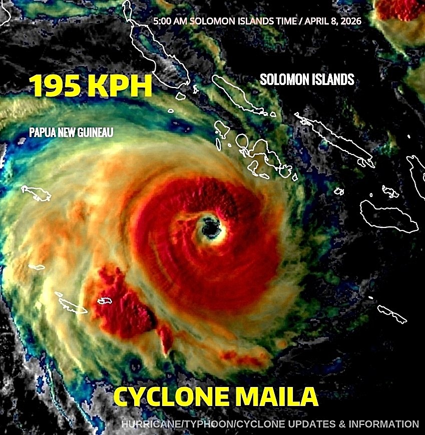
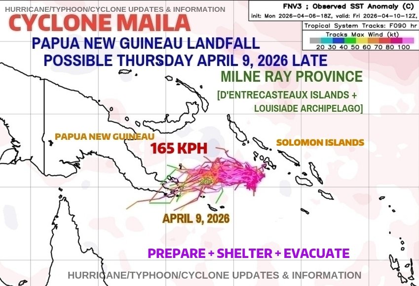
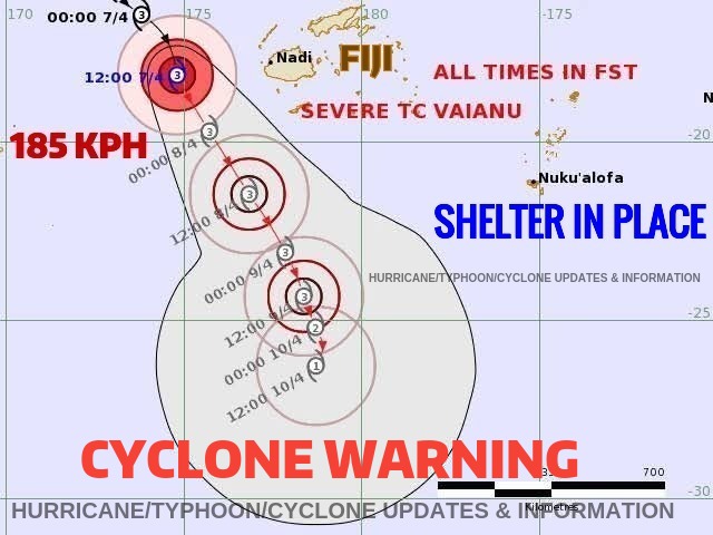
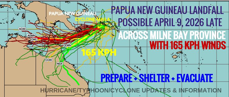
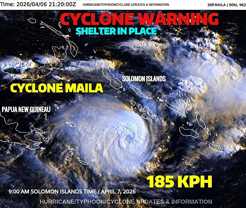
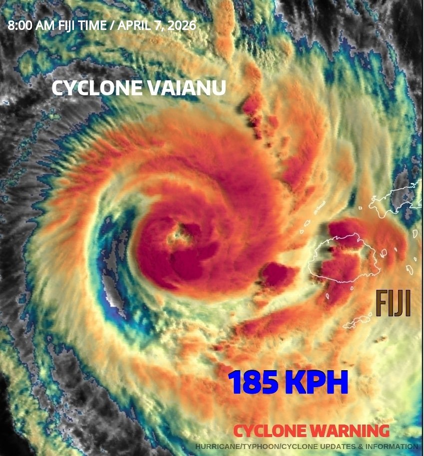
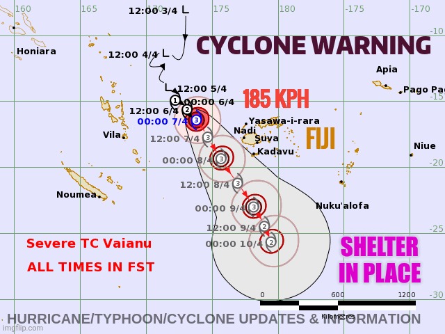
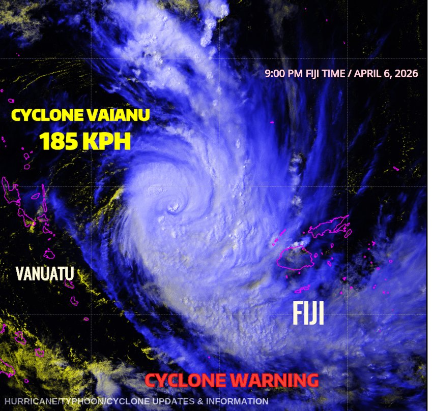
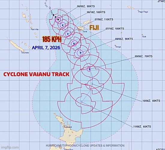
* At 7 :00 AM Fiji time, April 8, 2026, CYCLONE #Vaianu with 150 kph winds is trackimg south at 19 kph and is located 200 kilometers southwest of all Fiji Islands. Lingering tropical showers will occur Wednesday April 8, 2026; however, improving weather conditions will occur by evening. Friends/People of Fiji, I pray everyone is safe, and your property is intact without damage. Respectfully, Roshin Hurricane/Typhoon/Cyclone Updates & Information
GIF
English
0
0
1
90
Hurricanes • Typhoons • Cyclones
Severe Tropical Cyclone #Maila, in the Solomon Sea. - 5: 00 AM Solomon Islands Time / April 8, 2026 Intensity Category 4, sustained winds near the centre of 195 kilometres per hour with wind gusts to 270 kilometres per hour Location Within 30 kilometres of 9.8 degrees South, 156.3 degrees East, 405 kilometres west of Honiara and 1000 kilometres east of Port Moresby Movement Stationary Severe Tropical Cyclone Maila, 37U / 90P, is currently located over the Solomon Sea. The steering influences are nearly balanced and Maila is expected to remain slow moving tonight before it begins turning west southwest on Wednesday April 8, 2026. Tropical Cyclone Maila may make a LANDFALL or close brush late Thursday April 9, 2026 into froday April 10, 2026 across Milne Province near D'Entrecasteaux Islands & Louisiade Archipelago. Tropical Cyclone Maila is intensifying and slow moving in the Solomon Sea. A CYCLONE WARNING remains active for the Solomon Islands & Papua New Guineau. Cyclone Maila has reached Category 4 status with 195 kph winds + 270 kph gusts. SHELTER IN PLACE from ongoing life-threatening floods April 8-12, 2026. Follow Hurricane/Typhoon/Cyclone Updates & Information for updates 24/7.
Hurricanes • Typhoons • Cyclones tweet media
English
0
0
2
114
Hurricanes • Typhoons • Cyclones
Severe Tropical Cyclone #Maila, in the Solomon Sea. - 5: 00 AM Solomon Islands Time / April 8, 2026 Intensity Category 4, sustained winds near the centre of 195 kilometres per hour with wind gusts to 270 kilometres per hour Location Within 30 kilometres of 9.8 degrees South, 156.3 degrees East, 405 kilometres west of Honiara and 1000 kilometres east of Port Moresby Movement Stationary Severe Tropical Cyclone Maila, 37U / 90P, is currently located over the Solomon Sea. The steering influences are nearly balanced and Maila is expected to remain slow moving tonight before it begins turning west southwest on Wednesday April 8, 2026. Tropical Cyclone Maila may make a LANDFALL or close brush late Thursday April 9, 2026 into froday April 10, 2026 across Milne Province near D'Entrecasteaux Islands & Louisiade Archipelago. Tropical Cyclone Maila is intensifying and slow moving in the Solomon Sea. A CYCLONE WARNING remains active for the Solomon Islands & Papua New Guineau. Cyclone Maila has reached Category 4 status with 195 kph winds + 270 kph gusts. SHELTER IN PLACE from ongoing life-threatening floods April 8-12, 2026. Follow Hurricane/Typhoon/Cyclone Updates & Information for updates 24/7.
Hurricanes • Typhoons • Cyclones tweet media
English
0
0
1
120
Hurricanes • Typhoons • Cyclones
🌀 TROPICAL CYCLONE FIJI UPDATE 9: 00 PM Fiji Time | Tuesday, April 7, 2026 TROPICAL CYCLONE #VAIANU has 185 kph winds (JTWC) and is tracking to the south-southeast at 17 kph in the South Pacific Ocean basin, now located southwest of Fiji. "Hurricane, Typhoon, Cyclone Updates and Information" continues a CYCLONE WARNING for all Fiji Islands, even though the path is west of Fiji proper. Fiji Met continues heavy rain, wind warnings, and marine warnings across all Fiji Islands. Although CYCLONE Vaianu is west of Fiji, residents are advised to SHELTER IN PLACE as needed as Cyclone Vaianu is bringing tropical storm-force winds of 75 to 105 kilometers per hour, with possible, stronger wind gusts of 115 to 130 kilometers per hour. The system has been moving well west of all the Fiji Islands, today, Tuesday, April 7, 2026, bringing dangerous marine conditions across the region. A DIRECT LANDFALL across the Fiji Islands will NOT occur; however, indirect impacts from Tropical Cyclone Vaianu are significant and ongoing requiring people/friends to SHELTER IN PLACE. Persistent and strong tropical rain bands are widespread across Fiji, bringing the threat of flash flooding, river flooding, localized landslides, and reduced visibility. Winds may be damaging in exposed coastal and elevated locations, and very rough to tremendous seas are expected with dangerous surf and a possible 0.5 to 1 meter storm surge, especially near high tide. Please continue to closely follow the Fiji Meteorological Service and Hurricane/Typhoon/Cyclone Updates & Information page for trusted cyclone updates 24/7. 🌀 Next key period: Tuesday, April 7 — closest approach just west of Fiji with strongest winds, heaviest rain, and highest flooding threat.
GIF
English
0
0
1
149
Hurricanes • Typhoons • Cyclones
🌀 TROPICAL CYCLONE FIJI UPDATE 9: 00 PM Fiji Time | Tuesday, April 7, 2026 TROPICAL CYCLONE #VAIANU has 185 kph winds (JTWC) and is tracking to the south-southeast at 17 kph in the South Pacific Ocean basin, now located southwest of Fiji. "Hurricane, Typhoon, Cyclone Updates and Information" continues a CYCLONE WARNING for all Fiji Islands, even though the path is west of Fiji proper. Fiji Met continues heavy rain, wind warnings, and marine warnings across all Fiji Islands. Although CYCLONE Vaianu is west of Fiji, residents are advised to SHELTER IN PLACE as needed as Cyclone Vaianu is bringing tropical storm-force winds of 75 to 105 kilometers per hour, with possible, stronger wind gusts of 115 to 130 kilometers per hour. The system has been moving well west of all the Fiji Islands, today, Tuesday, April 7, 2026, bringing dangerous marine conditions across the region. A DIRECT LANDFALL across the Fiji Islands will NOT occur; however, indirect impacts from Tropical Cyclone Vaianu are significant and ongoing requiring people/friends to SHELTER IN PLACE. Persistent and strong tropical rain bands are widespread across Fiji, bringing the threat of flash flooding, river flooding, localized landslides, and reduced visibility. Winds may be damaging in exposed coastal and elevated locations, and very rough to tremendous seas are expected with dangerous surf and a possible 0.5 to 1 meter storm surge, especially near high tide. Please continue to closely follow the Fiji Meteorological Service and Hurricane/Typhoon/Cyclone Updates & Information page for trusted cyclone updates 24/7. 🌀 Next key period: Tuesday, April 7 — closest approach just west of Fiji with strongest winds, heaviest rain, and highest flooding threat.
Hurricanes • Typhoons • Cyclones tweet media
English
0
0
0
146
Hurricanes • Typhoons • Cyclones
🌀 TROPICAL CYCLONE FIJI UPDATE 13: 00 PM Fiji Time | Tuesday, April 7, 2026 TROPICAL CYCLONE #VAIANU has 185 kph winds (JTWC) and is tracking to the south-southeast at 18 kph in the South Pacific Ocean basin between Fiji and Vanuatu. Due to the projected track and continued strengthening, "Hurricane, Typhoon, Cyclone Updates and Information" continues a CYCLONE WARNING for all Fiji Islands, even though the path will be well west of Fiji proper. Fiji Met has issued heavy rain and wind warnings across all Fiji Islands. Although CYCLONE Vaianu will track west of Fiji, residents are advised to SHELTER IN PLACE as needed as Cyclone Vaianu will bring tropical storm-force winds of 75 to 105 kilometers per hour, with possible, stronger wind gusts of 115 to 130 kilometers per hour. The system is forecast to move well west of all the Fiji Islands on Tuesday, April 7, 2026, bringing dangerous marine conditions across the region. FIJI MET guidance forecast supports steady intensification through at least the next 12 hours into a Category 3 CYCLONE with winds of 120-160 kph. JTWC forecasts a Category 4 CYCLONE with winds of 185-195 kph. A DIRECT LANDFALL across the Fiji Islands and or Vanuatu will NOT occur; however, indirect impacts from Tropical Cyclone Vaianu will be significant requiring early preparation and SHELTER as needed. Persistent and strong tropical rain bands will continue to increase and become much more widespread across Fiji, bringing the threat of flash flooding, river flooding, localized landslides, and reduced visibility. Winds may become damaging in exposed coastal and elevated locations, and very rough to tremendous seas are expected with dangerous surf and a possible 0.5 to 1 meter storm surge, especially near high tide. Please continue to closely follow the Fiji Meteorological Service and Hurricane/Typhoon/Cyclone Updates & Information page for trusted cyclone updates 24/7. 🌀 Next key period: Tuesday, April 7 — closest approach just west of Fiji with strongest winds, heaviest rain, and highest flooding threat.
Hurricanes • Typhoons • Cyclones tweet media
English
0
0
0
160
Hurricanes • Typhoons • Cyclones
Severe Tropical Cyclone #Maila in the Solomon Sea - 9: 00 AM Solomon Islands Time / April 7, 2026 Intensity Category 3, sustained winds near the centre of 150 kilometres per hour with wind gusts to 205 kilometres per hour Location Within 35 kilometres of 9.8 degrees South, 156.0 degrees East, 440 kilometres west of Honiara and 970 kilometres east of Port Moresby Movement East-northeast at 9 kilometres per hour Severe Tropical Cyclone Maila, 37U / 90P, is currently located in the Solomon Sea. The steering influences are balanced and Maila is expected to be slow moving over the Solomon Sea before moving west southwest by Thursday April 9, 2014 towards the southeast Papua New Guineau peminsula. Tropical Cyclone Maila is intensifying and slow moving in the Solomon Sea. A CYCLONE WARNING remains active for the Solomon Islands & Papua New Guineau. Cyclone Maila is expected to reach sustained Category 4 status with 185 kph winds + 250 kph gusts. SHELTER IN PLACE from ongoing life-threatening floods April 7-12, 2026. Follow Hurricane/Typhoon/Cyclone Updates & Information for updates 24/7.
Hurricanes • Typhoons • Cyclones tweet media
English
0
1
1
147
Hurricanes • Typhoons • Cyclones
Severe Tropical Cyclone #Maila in the Solomon Sea - 9: 00 AM Solomon Islands Time / April 7, 2026 Intensity Category 3, sustained winds near the centre of 150 kilometres per hour with wind gusts to 205 kilometres per hour Location Within 35 kilometres of 9.8 degrees South, 156.0 degrees East, 440 kilometres west of Honiara and 970 kilometres east of Port Moresby Movement East-northeast at 9 kilometres per hour Severe Tropical Cyclone Maila, 37U / 90P, is currently located in the Solomon Sea. The steering influences are balanced and Maila is expected to be slow moving over the Solomon Sea before moving west southwest by Thursday April 9, 2014 towards the southeast Papua New Guineau peminsula. Tropical Cyclone Maila is intensifying and slow moving in the Solomon Sea. A CYCLONE WARNING remains active for the Solomon Islands & Papua New Guineau. Cyclone Maila is expected to reach sustained Category 4 status with 185 kph winds + 250 kph gusts. SHELTER IN PLACE from ongoing life-threatening floods April 7-12, 2026. Follow Hurricane/Typhoon/Cyclone Updates & Information for updates 24/7.
Hurricanes • Typhoons • Cyclones tweet media
English
0
1
0
179
Hurricanes • Typhoons • Cyclones
🌀 TROPICAL CYCLONE FIJI UPDATE 8: 00 AM Fiji Time | Tuesday, April 7, 2026 TROPICAL CYCLONE #VAIANU has 185 kph winds (JTWC) and is tracking to the south-southeast at 18 kph in the South Pacific Ocean basin between Fiji and Vanuatu. Due to the projected track and continued strengthening, "Hurricane, Typhoon, Cyclone Updates and Information" continues a CYCLONE WARNING for all Fiji Islands, even though the path will be well west of Fiji proper. Fiji Met has issued heavy rain and wind warnings across all Fiji Islands. Although CYCLONE Vaianu will track west of Fiji, residents are advised to SHELTER IN PLACE as needed as Cyclone Vaianu will bring tropical storm-force winds of 75 to 105 kilometers per hour, with possible, stronger wind gusts of 115 to 130 kilometers per hour. The system is forecast to move well west of all the Fiji Islands on Tuesday, April 7, 2026, bringing dangerous marine conditions across the region. FIJI MET guidance forecast supports steady intensification through at least the next 12 hours into a Category 3 CYCLONE with winds of 120-160 kph. JTWC forecasts a Category 4 CYCLONE with winds of 185-195 kph. A DIRECT LANDFALL across the Fiji Islands and or Vanuatu will NOT occur; however, indirect impacts from Tropical Cyclone Vaianu will be significant requiring early preparation and SHELTER as needed. Persistent and strong tropical rain bands will continue to increase and become much more widespread across Fiji, bringing the threat of flash flooding, river flooding, localized landslides, and reduced visibility. Winds may become damaging in exposed coastal and elevated locations, and very rough to tremendous seas are expected with dangerous surf and a possible 0.5 to 1 meter storm surge, especially near high tide. Please continue to closely follow the Fiji Meteorological Service and Hurricane/Typhoon/Cyclone Updates & Information page for trusted cyclone updates 24/7. 🌀 Next key period: Tuesday, April 7 — closest approach just west of Fiji with strongest winds, heaviest rain, and highest flooding threat.
Hurricanes • Typhoons • Cyclones tweet media
English
0
1
3
190
Hurricanes • Typhoons • Cyclones
🌀 TROPICAL CYCLONE FIJI UPDATE 5: 00 AM Fiji Time | Tuesday, April 7, 2026 TROPICAL CYCLONE #VAIANU has 185 kph winds (JTWC) and is tracking to the south-southeast at 18 kph in the South Pacific Ocean basin between Fiji and Vanuatu. Due to the projected track and continued strengthening, "Hurricane, Typhoon, Cyclone Updates and Information" continues a CYCLONE WARNING for all Fiji Islands, even though the path will be well west of Fiji proper. Fiji Met has issued heavy rain and wind warnings across all Fiji Islands. Although CYCLONE Vaianu will track west of Fiji, residents are advised to SHELTER IN PLACE as needed as Cyclone Vaianu will bring tropical storm-force winds of 75 to 105 kilometers per hour, with possible, stronger wind gusts of 115 to 130 kilometers per hour. The system is forecast to move well west of all the Fiji Islands on Tuesday, April 7, 2026, bringing dangerous marine conditions across the region. FIJI MET guidance forecast supports steady intensification through at least the next 12 hours into a Category 3 CYCLONE with winds of 120-160 kph. JTWC forecasts a Category 4 CYCLONE with winds of 185-195 kph. A DIRECT LANDFALL across the Fiji Islands and or Vanuatu will NOT occur; however, indirect impacts from Tropical Cyclone Vaianu will be significant requiring early preparation and SHELTER as needed. Persistent and strong tropical rain bands will continue to increase and become much more widespread across Fiji, bringing the threat of flash flooding, river flooding, localized landslides, and reduced visibility. Winds may become damaging in exposed coastal and elevated locations, and very rough to tremendous seas are expected with dangerous surf and a possible 0.5 to 1 meter storm surge, especially near high tide. Please continue to closely follow the Fiji Meteorological Service and Hurricane/Typhoon/Cyclone Updates & Information page for trusted cyclone updates 24/7. 🌀 Next key period: Tuesday, April 7 — closest approach just west of Fiji with strongest winds, heaviest rain, and highest flooding threat.
Hurricanes • Typhoons • Cyclones tweet media
English
0
0
0
168
Hurricanes • Typhoons • Cyclones
🌀 TROPICAL CYCLONE FIJI UPDATE 2: 00 AM Fiji Time | Tuesday, April 7, 2026 TROPICAL CYCLONE #VAIANU has 165 kph winds and is tracking to the south-southeast at 16 kph in the South Pacific Ocean basin between Fiji and Vanuatu. Due to the projected track and continued strengthening, "Hurricane, Typhoon, Cyclone Updates and Information" continues a CYCLONE WARNING for all Fiji Islands, even though the path will be well west of Fiji proper. Fiji Met has issued heavy rain and wind warnings across all Fiji Islands. Although CYCLONE Vaianu will track west of Fiji, residents are advised to SHELTER IN PLACE as needed as Cyclone Vaianu will bring tropical storm-force winds of 75 to 105 kilometers per hour, with possible, stronger wind gusts of 115 to 130 kilometers per hour. The system is forecast to move well west of all the Fiji Islands on Tuesday, April 7, 2026, bringing dangerous marine conditions across the region. Forecast guidance also supports steady intensification through at least the next 48 hours into a Category 3 CYCLONE with winds of 120-160 kph. JTWC forecasts a Category 4 CYCLONE with winds of 185-200 kph. A DIRECT LANDFALL across the Fiji Islands and or Vanuatu will NOT occur; however, indirect impacts from Tropical Cyclone Vaianu will be significant requiring early preparation and SHELTER as needed. Persistent and strong tropical rain bands will continue to increase and become much more widespread across Fiji, bringing the threat of flash flooding, river flooding, localized landslides, and reduced visibility. Winds may become damaging in exposed coastal and elevated locations, and very rough to tremendous seas are expected with dangerous surf and a possible 0.5 to 1 meter storm surge, especially near high tide. Please continue to closely follow the Fiji Meteorological Service and Hurricane/Typhoon/Cyclone Updates & Information page for trusted cyclone updates 24/7. 🌀 Next key period: Tuesday, April 7 — closest approach just west of Fiji with strongest winds, heaviest rain, and highest flooding threat.
GIF
English
0
3
7
746
Hurricanes • Typhoons • Cyclones
🌀 TROPICAL CYCLONE FIJI UPDATE 1: 00 AM Fiji Time | Tuesday, April 7, 2026 TROPICAL CYCLONE #VAIANU has 165 kph winds and is tracking to the south-southeast at 16 kph in the South Pacific Ocean basin between Fiji and Vanuatu. Due to the projected track and continued strengthening, "Hurricane, Typhoon, Cyclone Updates and Information" continues a CYCLONE WARNING for all Fiji Islands, even though the path will be well west of Fiji proper. Fiji Met has issued heavy rain and wind warnings across all Fiji Islands. Although CYCLONE Vaianu will track west of Fiji, residents are advised to SHELTER IN PLACE as needed as Cyclone Vaianu will bring tropical storm-force winds of 75 to 105 kilometers per hour, with possible, stronger wind gusts of 115 to 130 kilometers per hour. The system is forecast to move well west of all the Fiji Islands on Tuesday, April 7, 2026, bringing dangerous marine conditions across the region. Forecast guidance also supports steady intensification through at least the next 48 hours into a Category 3 CYCLONE with winds of 120-160 kph. JTWC forecasts a Category 4 CYCLONE with winds of 185-200 kph. A DIRECT LANDFALL across the Fiji Islands and or Vanuatu will NOT occur; however, indirect impacts from Tropical Cyclone Vaianu will be significant requiring early preparation and SHELTER as needed. Persistent and strong tropical rain bands will continue to increase and become much more widespread across Fiji, bringing the threat of flash flooding, river flooding, localized landslides, and reduced visibility. Winds may become damaging in exposed coastal and elevated locations, and very rough to tremendous seas are expected with dangerous surf and a possible 0.5 to 1 meter storm surge, especially near high tide. Please continue to closely follow the Fiji Meteorological Service and Hurricane/Typhoon/Cyclone Updates & Information page for trusted cyclone updates 24/7. 🌀 Next key period: Tuesday, April 7 — closest approach just west of Fiji with strongest winds, heaviest rain, and highest flooding threat.
Hurricanes • Typhoons • Cyclones tweet media
English
0
1
0
136
Hurricanes • Typhoons • Cyclones
🌀 TROPICAL CYCLONE FIJI UPDATE 9: 00 PM Fiji Time | Monday, April 6, 2026 TROPICAL CYCLONE #VAIANU has 165 kph winds and is tracking to the south-southeast at 16 kph in the South Pacific Ocean basin between Fiji and Vanuatu. Due to the projected track and continued strengthening, "Hurricane, Typhoon, Cyclone Updates and Information" continues a CYCLONE WARNING for all Fiji Islands, even though the path will be well west of Fiji proper. Fiji Met has issued heavy rain and wind warnings across all Fiji Islands. Although CYCLONE Vaianu will track west of Fiji, residents are advised to SHELTER IN PLACE as needed as Cyclone Vaianu will bring tropical storm-force winds of 75 to 105 kilometers per hour, with possible, stronger wind gusts of 115 to 130 kilometers per hour. The system is forecast to move well west of all the Fiji Islands on Tuesday, April 7, 2026, bringing dangerous marine conditions across the region. Forecast guidance also supports steady intensification through at least the next 48 hours into a Category 3 CYCLONE with winds of 120-160 kph. JTWC forecasts a Category 4 CYCLONE with winds of 185-200 kph. A DIRECT LANDFALL across the Fiji Islands and or Vanuatu will NOT occur; however, indirect impacts from Tropical Cyclone Vaianu will be significant requiring early preparation and SHELTER as needed. Persistent and strong tropical rain bands will continue to increase and become much more widespread across Fiji, bringing the threat of flash flooding, river flooding, localized landslides, and reduced visibility. Winds may become damaging in exposed coastal and elevated locations, and very rough to tremendous seas are expected with dangerous surf and a possible 0.5 to 1 meter storm surge, especially near high tide. Please continue to closely follow the Fiji Meteorological Service and Hurricane/Typhoon/Cyclone Updates & Information page for trusted cyclone updates 24/7. 🌀 Next key period: Tuesday, April 7 — closest approach just west of Fiji with strongest winds, heaviest rain, and highest flooding threat.
Hurricanes • Typhoons • Cyclones tweet media
English
0
3
3
197
Hurricanes • Typhoons • Cyclones
🌀 TROPICAL CYCLONE FIJI UPDATE 9: 00 PM Fiji Time | Monday, April 6, 2026 TROPICAL CYCLONE #VAIANU has 165 kph winds and is tracking to the south-southeast at 16 kph in the South Pacific Ocean basin between Fiji and Vanuatu. Due to the projected track and continued strengthening, "Hurricane, Typhoon, Cyclone Updates and Information" continues a CYCLONE WARNING for all Fiji Islands, even though the path will be well west of Fiji proper. Fiji Met has issued heavy rain and wind warnings across all Fiji Islands. Although CYCLONE Vaianu will track west of Fiji, residents are advised to SHELTER IN PLACE as needed as Cyclone Vaianu will bring tropical storm-force winds of 75 to 105 kilometers per hour, with possible, stronger wind gusts of 115 to 130 kilometers per hour. The system is forecast to move well west of all the Fiji Islands on Tuesday, April 7, 2026, bringing dangerous marine conditions across the region. Forecast guidance also supports steady intensification through at least the next 48 hours into a Category 3 CYCLONE with winds of 120-160 kph. JTWC forecasts a Category 4 CYCLONE with winds of 185-200 kph. A DIRECT LANDFALL across the Fiji Islands and or Vanuatu will NOT occur; however, indirect impacts from Tropical Cyclone Vaianu will be significant requiring early preparation and SHELTER as needed. Persistent and strong tropical rain bands will continue to increase and become much more widespread across Fiji, bringing the threat of flash flooding, river flooding, localized landslides, and reduced visibility. Winds may become damaging in exposed coastal and elevated locations, and very rough to tremendous seas are expected with dangerous surf and a possible 0.5 to 1 meter storm surge, especially near high tide. Please continue to closely follow the Fiji Meteorological Service and Hurricane/Typhoon/Cyclone Updates & Information page for trusted cyclone updates 24/7. 🌀 Next key period: Tuesday, April 7 — closest approach just west of Fiji with strongest winds, heaviest rain, and highest flooding threat.
Hurricanes • Typhoons • Cyclones tweet media
English
0
1
2
156
Hurricanes • Typhoons • Cyclones
🌀 TROPICAL CYCLONE FIJI UPDATE 9: 00 PM Fiji Time | Monday, April 6, 2026 TROPICAL CYCLONE #VAIANU has 165 kph winds and is tracking to the south-southeast at 16 kph in the South Pacific Ocean basin between Fiji and Vanuatu. Due to the projected track and continued strengthening, "Hurricane, Typhoon, Cyclone Updates and Information" continues a CYCLONE WARNING for all Fiji Islands, even though the path will be well west of Fiji proper. Fiji Met has issued heavy rain and wind warnings across all Fiji Islands. Although CYCLONE Vaianu will track west of Fiji, residents are advised to SHELTER IN PLACE as needed as Cyclone Vaianu will bring tropical storm-force winds of 75 to 105 kilometers per hour, with possible, stronger wind gusts of 115 to 130 kilometers per hour. The system is forecast to move well west of all the Fiji Islands on Tuesday, April 7, 2026, bringing dangerous marine conditions across the region. Forecast guidance also supports steady intensification through at least the next 48 hours into a Category 3 CYCLONE with winds of 120-160 kph. JTWC forecasts a Category 4 CYCLONE with winds of 185-200 kph. A DIRECT LANDFALL across the Fiji Islands and or Vanuatu will NOT occur; however, indirect impacts from Tropical Cyclone Vaianu will be significant requiring early preparation and SHELTER as needed. Persistent and strong tropical rain bands will continue to increase and become much more widespread across Fiji, bringing the threat of flash flooding, river flooding, localized landslides, and reduced visibility. Winds may become damaging in exposed coastal and elevated locations, and very rough to tremendous seas are expected with dangerous surf and a possible 0.5 to 1 meter storm surge, especially near high tide. Please continue to closely follow the Fiji Meteorological Service and Hurricane/Typhoon/Cyclone Updates & Information page for trusted cyclone updates 24/7. 🌀 Next key period: Tuesday, April 7 — closest approach just west of Fiji with strongest winds, heaviest rain, and highest flooding threat.
Hurricanes • Typhoons • Cyclones tweet media
English
0
0
1
129
Hurricanes • Typhoons • Cyclones
Severe Tropical Cyclone #Maila in the Solomon Sea - 7:00 PM Solomon Islands Time / April 6, 2026 Intensity Category 3, sustained winds near the centre of 130 kilometres per hour with wind gusts to 185 kilometres per hour Location Within 35 kilometres of 9.9 degrees South, 155.2 degrees East, 525 kilometres west of Honiara and 880 kilometres east of Port Moresby Movement Southeast at 7 kilometres per hour Severe Tropical #CycloneMaila, 37U / 90P, is currently located in the Solomon Sea. The steering influences are balanced and Maila is expected to be slow moving over the Solomon Sea before moving west southwest by Thursday April 9, 2026 towards southeast Papua New Guineau peninsula. #TropicalCycloneMaila is intensifying and slow moving in the Solomon Sea. A CYCLONE WARNING remains active for the Solomon Islands & Papua New Guineau. Cyclone Maila ia expected to reach sustained Category 4 status with 185 kph winds + 250 kph gusts. SHELTER IN PLACE from ongoing life-threatening floods April 6-12, 2026. Follow Hurricane/Typhoon/Cyclone Updates & Information for updates 24/7.
Hurricanes • Typhoons • Cyclones tweet media
English
0
0
2
137