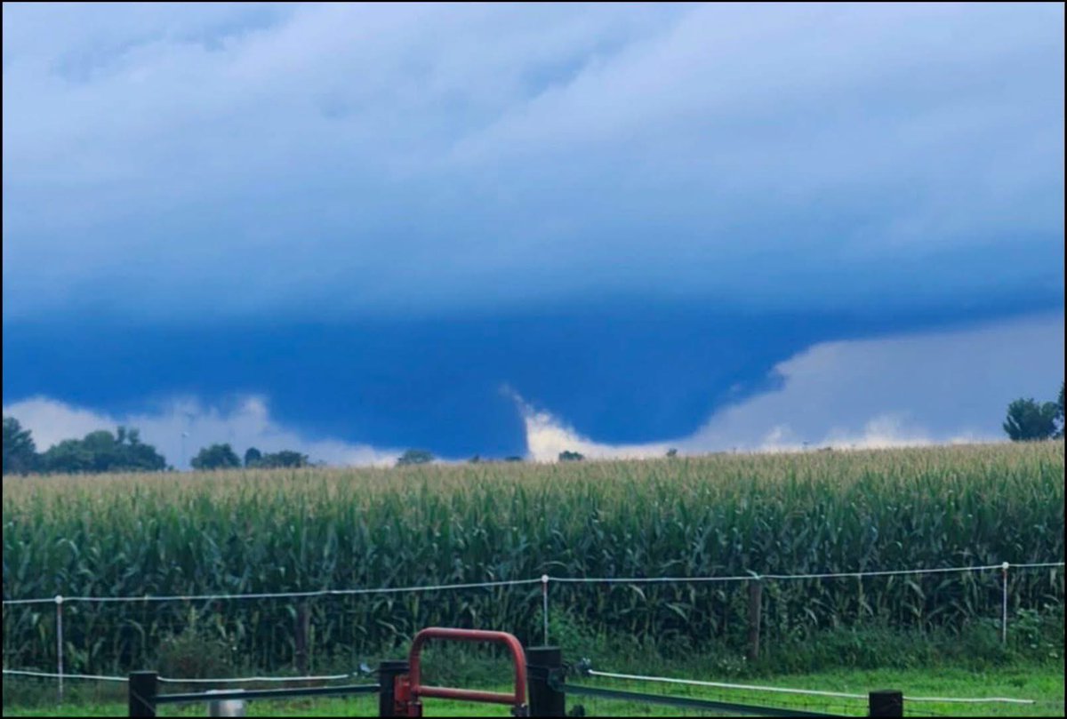
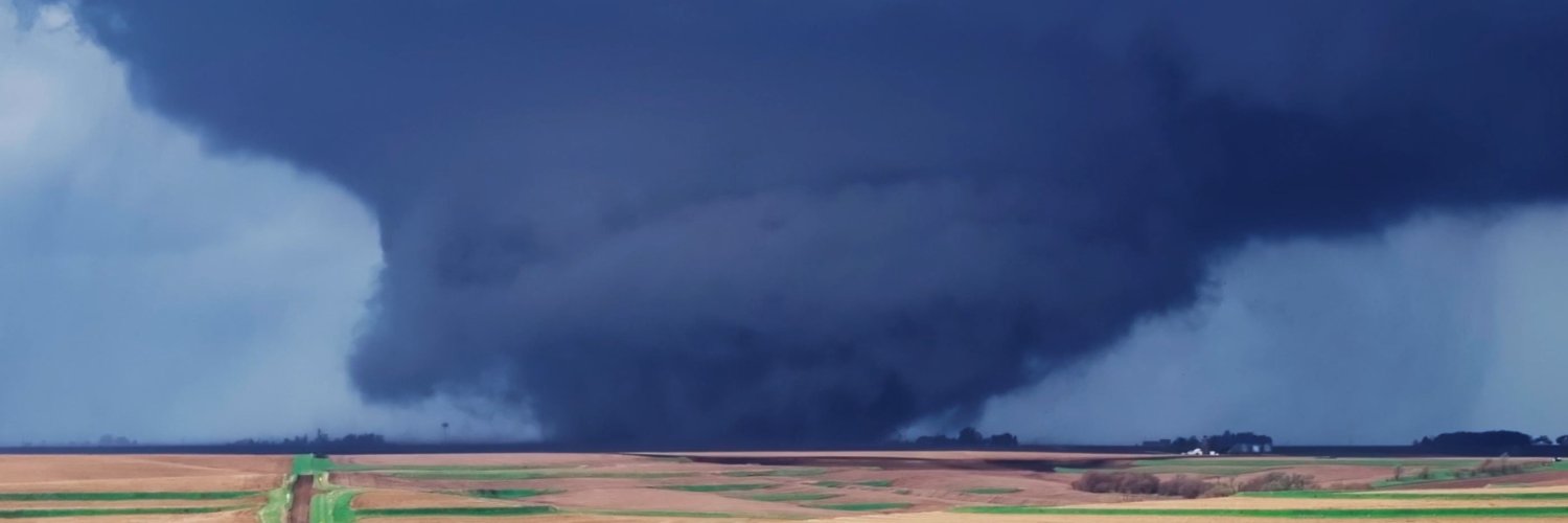
IowaWeather.com

11.2K posts

IowaWeather.com banner
IowaWeather.com

IowaWeather.com

@IAStormChasing

The largest online Iowa weather network. Bringing you the best weather coverage devoted only to online viewers. #iawx

Iowa Katılım Nisan 2010
2.7K Takip Edilen24.7K Takipçiler
IowaWeather.com
IowaWeather.com@IAStormChasing·
A tornado watch has been issued for parts of Iowa, Minnesota, Nebraska and South Dakota until 10 PM CDT. Severe thunderstorms are expected to increase this afternoon as a cold front moves into the region. Some storms could become powerful supercells capable of producing all types of severe weather, including very large hail up to 3 inches in diameter, damaging wind gusts, and strong tornadoes. As storms begin to form into a line later in the day, the threat for damaging straight-line winds and brief tornadoes will continue, especially across northwest Iowa and nearby portions of Nebraska, South Dakota, and Minnesota. #iawx #newx #sdwx #mnwx #tornadowatch #tornado
IowaWeather.com tweet media
English
2
2
13
1.8K
IowaWeather.com
IowaWeather.com@IAStormChasing·
Damaging wind gusts will be one of the primary concerns here in Iowa, mainly across northwest Iowa. The line will have a weakening trend as it moves east across Iowa.
IowaWeather.com tweet media
English
0
0
4
788
IowaWeather.com
IowaWeather.com@IAStormChasing·
Large hail will be more of a concern back into Nebraska and SE South Dakota.
IowaWeather.com tweet media
English
1
0
6
1.2K
IowaWeather.com
IowaWeather.com@IAStormChasing·
An Enhanced Risk of severe weather is in place today across parts of western Iowa. Storms are expected to develop late this afternoon across Nebraska and South Dakota before moving into western Iowa this evening and spreading east across the state overnight. The atmosphere will be favorable for severe thunderstorms capable of producing very large hail, damaging winds, and tornadoes. A few strong tornadoes may be possible across western Iowa this evening if storms can remain isolated early in their development. As storms move east overnight, they are expected to evolve into a larger line of storms with an increasing damaging wind threat while still capable of producing embedded tornadoes. #iawx #newx #sdwx #mnwx #tornado
IowaWeather.com tweet media
English
1
9
26
2.5K
IowaWeather.com
IowaWeather.com@IAStormChasing·
A tornado watch has been issued for parts of Iowa and Missouri until 11 PM CDT
IowaWeather.com tweet media
English
0
5
17
2K
IowaWeather.com
IowaWeather.com@IAStormChasing·
A Slight Risk for excessive rainfall and flash flooding is now in place tonight for areas near the Iowa/Missouri border, with additional heavy rain potential extending west into Nebraska and Kansas. Thunderstorms developing this afternoon and evening will have access to very warm, humid air capable of producing torrential rainfall rates. Some storms may repeatedly move over the same areas, leading to localized rainfall totals of 3 to 5 inches or more overnight. The highest concern currently appears to be across southern Iowa into northern Missouri where the Weather Prediction Center notes a significant flash flood threat could develop if storms begin backbuilding or training along a stationary boundary. Stay weather aware tonight, especially if you live in flood-prone or low-lying areas. Never drive through flooded roadways. #iawx #mowx #flashflooding
IowaWeather.com tweet media
English
0
1
17
2.1K
IowaWeather.com
IowaWeather.com@IAStormChasing·
Any of the initial storms across southern Iowa this afternoon could have an isolated tornado potential. The Storm Prediction Center (SPC) has a 5% out across southwest/south-central Iowa. #iawx
IowaWeather.com tweet media
English
0
2
7
1.3K
IowaWeather.com
IowaWeather.com@IAStormChasing·
A Slight Risk (Level 2 of 5) for severe weather is in place this afternoon and tonight for areas generally along and south of Highway 20 to the Iowa/Missouri border. Warm, humid air moving into the state will create an increasingly unstable atmosphere capable of supporting severe thunderstorms through the afternoon and evening hours. Initial storms may begin developing across central to southern Iowa after 3-4 PM and could quickly become severe with large hail, damaging wind gusts, and an isolated tornado threat. Any storms that remain isolated early on will have the greatest chance to produce tornadoes before storms are expected to merge into a larger line later this evening. Heavy rainfall will also be possible, with repeated storms capable of producing 2 to 3 inches of rain in localized areas and isolated higher totals possible. Attention will then turn to a larger complex of storms expected to develop across southwest Nebraska into northwest Kansas this evening before tracking eastward into Iowa overnight. Current timing would bring this activity into western Iowa after 2 AM. While storms may gradually weaken as they move east, damaging winds and heavy rain could still accompany this overnight activity. This complex will then push all of the activity out of the state by mid-morning Sunday. #iawx #iowaweather #severeweather
IowaWeather.com tweet media
English
1
4
13
2.5K
IowaWeather.com
IowaWeather.com@IAStormChasing·
WOW! Check out this video Samantha Beeson's camera captured near Red Oak tonight. We are getting lots of reports of damage in the area. The weather sensor in Red Oak measured a wind gust of 74-mph. #iawx #iowaweather #severeweather
English
2
13
86
9.3K
IowaWeather.com
IowaWeather.com@IAStormChasing·
A strong thunderstorm producing 70+ MPH wind gusts in Southwest Iowa is knocking out power. As of 7:30PM Friday, there are about 2,500 customers without power between Montgomery and Fremont counties. Most are in Montgomery county where a 74-mph wind gusts was measured in Red Oak.
IowaWeather.com tweet media
English
0
1
16
1.7K
IowaWeather.com
IowaWeather.com@IAStormChasing·
A severe thunderstorm watch has been issued for parts of Iowa, Minnesota, Nebraska and South Dakota until 1 AM CDT.
IowaWeather.com tweet media
English
0
0
10
1.3K
IowaWeather.com
IowaWeather.com@IAStormChasing·
A severe thunderstorm watch will be issued this afternoon. Severe thunderstorm potential is increasing this afternoon, and development is expected over the next couple of hours. Large hail to 3 inches diameter, scattered damaging wind gusts, and a tornado or two will be possible through evening. #iawx
IowaWeather.com tweet media
English
1
5
33
3.6K
IowaWeather.com
IowaWeather.com@IAStormChasing·
Strong to severe thunderstorms are expected to develop across #Iowa later today and tonight. This setup could support large hail and damaging winds. The Storm Prediction Center has now added an Enhanced Risk (Level 3 of 5) for severe weather today, highlighting the increasing concern for significant severe weather across the region. #iawx Read the latest forecast update: iowaweather.com/severe-storm-t…
IowaWeather.com tweet media
English
2
7
39
4.6K
IowaWeather.com
IowaWeather.com@IAStormChasing·
Parts of central and southwest Iowa are now under a Level 2 of 5 Slight Risk for severe weather on Friday, according to the Storm Prediction Center. Thunderstorms are expected to develop late Friday afternoon (after 5-6PM) and continue into the evening. Right now, large to very large hail appears to be the main threat with the strongest storms due to strong winds higher up in the atmosphere. Damaging wind gusts will also be possible if storms begin to merge into larger clusters during the evening hours. In addition, those who do receive thunderstorms may end up receiving 0.4" to 1" of rainfall by Saturday morning. Forecast models over the last 24 hours have shifted the greatest severe weather threat slightly farther north and northwest, which is why the SPC adjusted the risk area. Storms may continue into the overnight hours while tracking east across portions of the state. Now is a good time to review your severe weather safety plan and make sure you have a way to receive warnings Friday evening. #iawx #iowaweather #severeweather #Hail
IowaWeather.com tweet media
English
0
2
16
2.4K
IowaWeather.com
IowaWeather.com@IAStormChasing·
The National Weather Service has issued a Special Weather Statement for much of northern and western Iowa due to strong northwest winds causing areas of blowing dust through this evening. Strong northwest winds will gust between 35 and 45 MPH this afternoon, creating areas of blowing dust that could quickly reduce visibility to 1 mile or less in open farm fields. Dry conditions combined with the gusty winds may also allow any fires that start to spread rapidly. #iawx #iowaweather
IowaWeather.com tweet media
English
0
2
13
3.5K