IPTCWC

2K posts

IPTCWC banner
IPTCWC

IPTCWC

@IPTCWC

Indo-Pacific Tropical Cyclone Warning Center. Warning Agency issuing UNOFFICIAL forecasts for Tropical Cyclones in the North Indian Ocean and Northwest Pacific.

United States Katılım Ekim 2019
32 Takip Edilen2K Takipçiler
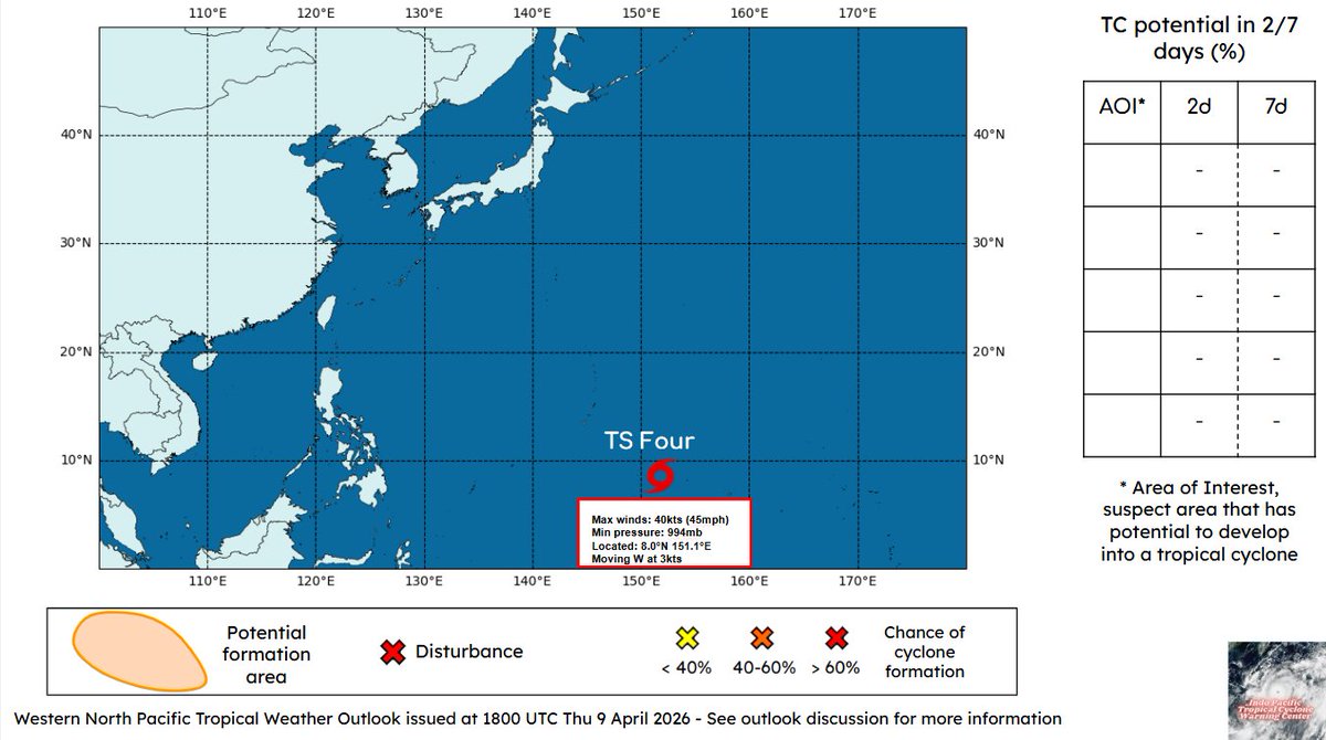
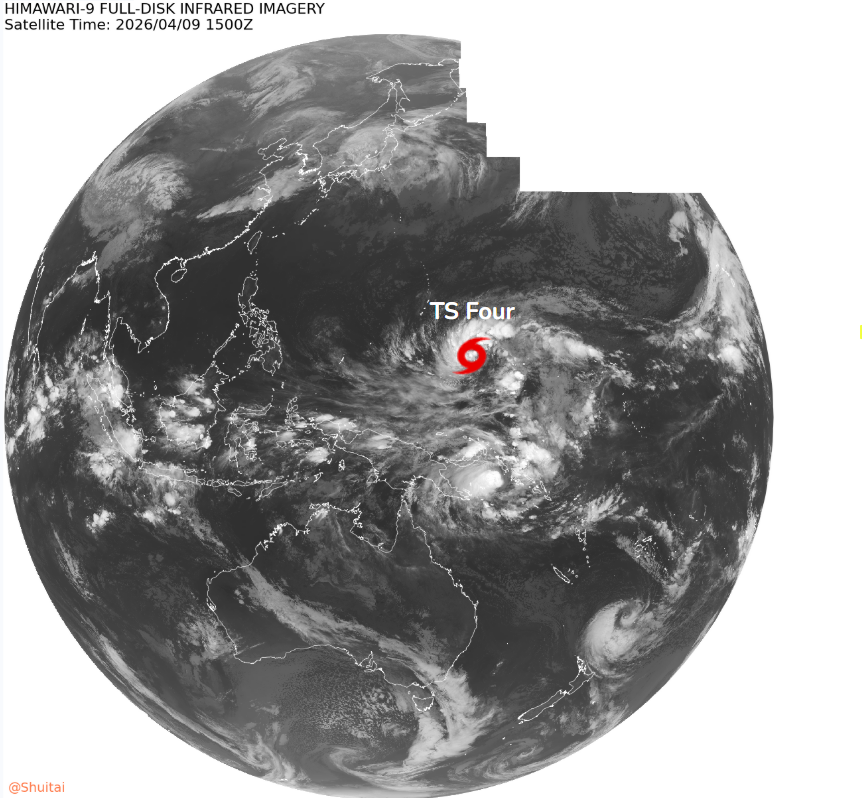
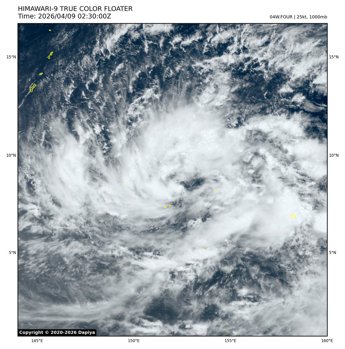
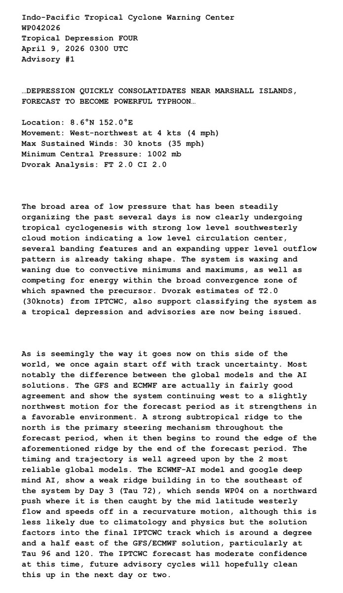
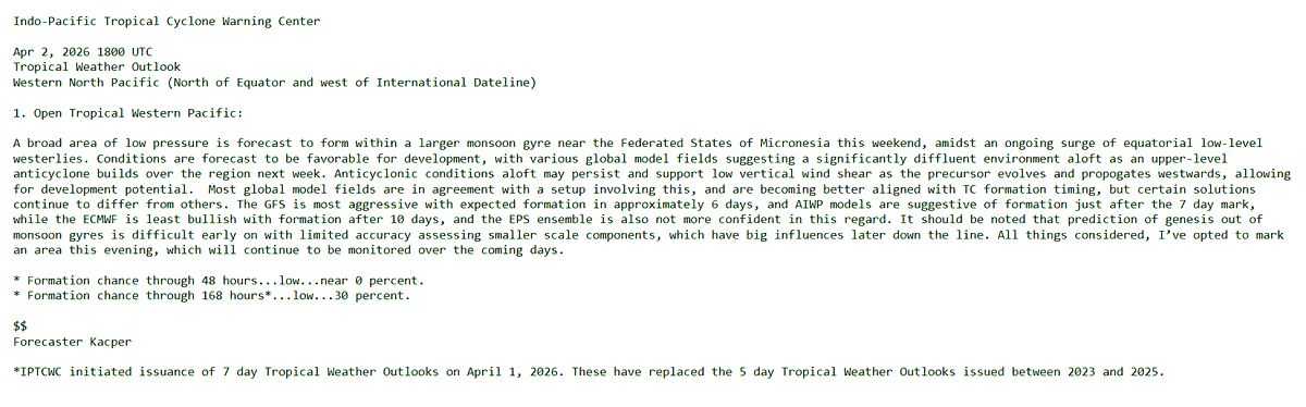
IPTCWC
IPTCWC@IPTCWC·
Western North Pacific Tropical Weather Outlook: The IPTCWC is issuing advisories on Tropical Storm #Four, located slightly to the northwest of Chuuk, Micronesia. Elsewhere, no new tropical cyclones are expected in the next seven days.
IPTCWC tweet mediaIPTCWC tweet mediaIPTCWC tweet media
English
0
0
3
79
IPTCWC
IPTCWC@IPTCWC·
IPTCWC TC Update 
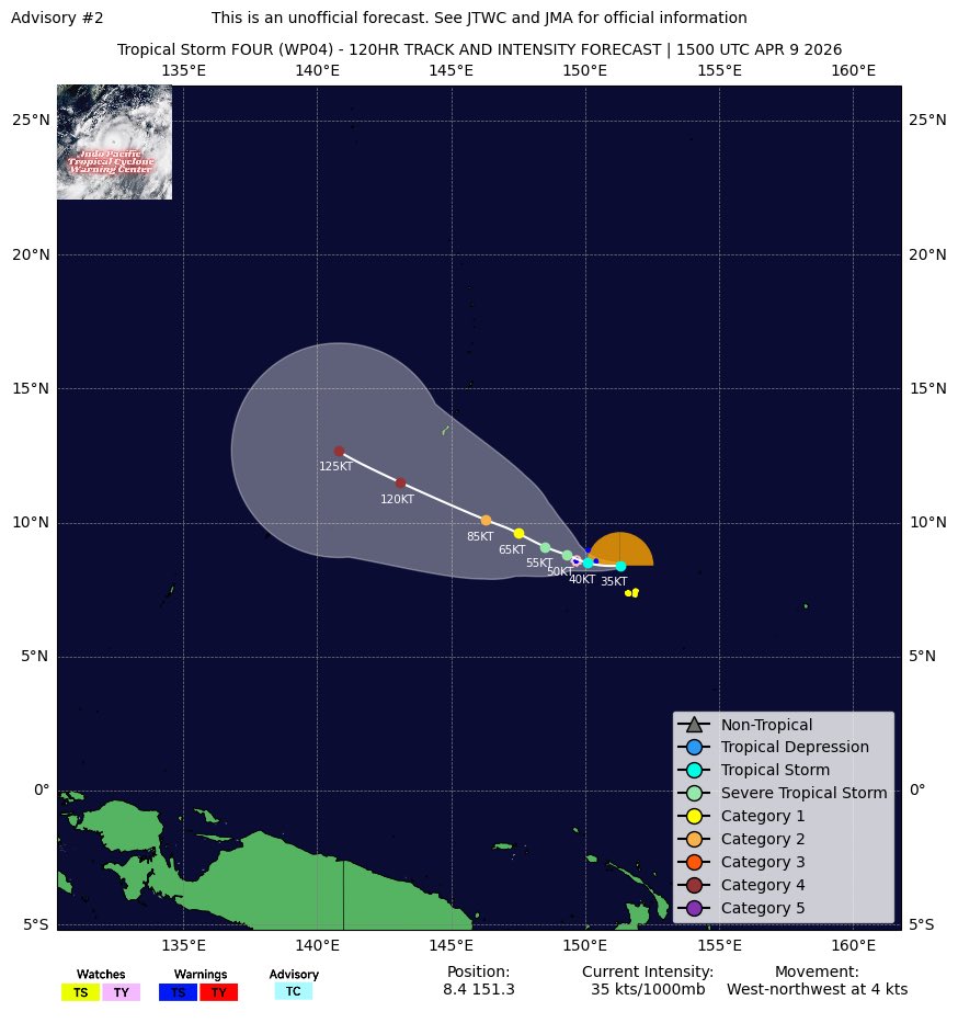
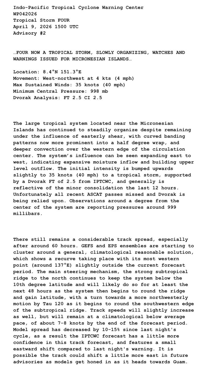
Tropical Storm Four Advisory #3 …FOUR EXPECTED TO BECOME A POWERFUL TYPHOON NEXT WEEK… Thu, Apr 09 2026 1800 UTC Location: 8.0N 151.1E Max Sustained Winds (1-min): 40kts (45mph) Central Pressure: 994mb Dvorak Analysis: FT3.0 CI3.0 Next advisory: 04/10 0300z
IPTCWC tweet media
English
0
1
10
210
IPTCWC
IPTCWC@IPTCWC·
Tropical Storm #FOUR Advisory #2: Four now a tropical storm, slowly organzing, watches and warnings issued for Micronesian Islands. Max winds have increased to 35knots (40mph). Significant typhoon possible, Guam highly advised to closely monitor. Click below for more info.
IPTCWC tweet mediaIPTCWC tweet mediaIPTCWC tweet mediaIPTCWC tweet media
English
0
3
11
576
IPTCWC
IPTCWC@IPTCWC·
Tropical Depression #FOUR Advisory #1: Depression quickly consolidates near Marshall Islands, forecast to become powerful typhoon. Max winds are at 30knots (35mph). Marianas Islands are strongly advised to closely monitor. Click below on IPTCWC cone and discussion for more info.
IPTCWC tweet mediaIPTCWC tweet mediaIPTCWC tweet mediaIPTCWC tweet media
English
0
3
10
1.2K
IPTCWC
IPTCWC@IPTCWC·
IPTCWC will initiate advisories on Tropical Depression WP04 (FOUR) at the next advisory cycle (04/09/26 03z) which is located approximately 592 Nautical miles east-southeast of Guam, Marianas Islands, US.
English
0
0
2
88
IPTCWC
IPTCWC@IPTCWC·
Western North Pacific Tropical Weather Outlook: An area of low pressure (Invest #90W) lies in the open Tropical West Pacific, southeast of the Mariana Islands. This system has a high 🔴 (near 100%) chance of tropical development through the next 7 days.
IPTCWC tweet mediaIPTCWC tweet mediaIPTCWC tweet media
English
0
1
7
315
IPTCWC
IPTCWC@IPTCWC·
Western North Pacific Tropical Weather Outlook: An area of interest lies in the open Tropical West Pacific, southeast of the Mariana Islands. This system has a high 🔴 (80%) chance of tropical development through the next 7 days.
IPTCWC tweet mediaIPTCWC tweet mediaIPTCWC tweet media
English
0
1
7
205
IPTCWC
IPTCWC@IPTCWC·
Western North Pacific Tropical Weather Outlook: An area of interest lies in the open Tropical West Pacific, southeast of the Mariana Islands. This system has a high 🔴 (70%) chance of tropical development through the next 7 days.
IPTCWC tweet mediaIPTCWC tweet mediaIPTCWC tweet media
English
0
6
32
1.5K
IPTCWC
IPTCWC@IPTCWC·
Western North Pacific Tropical Weather Outlook: A broad area of low pressure is forecast to form near the Federated States of Micronesia this weekend. This system has a medium 🟠 (50%) chance of tropical development through the next 7 days.
IPTCWC tweet mediaIPTCWC tweet mediaIPTCWC tweet media
English
0
3
21
637
IPTCWC
IPTCWC@IPTCWC·
Western North Pacific Tropical Weather Outlook: A broad area of low pressure is forecast to form near the Federated States of Micronesia this weekend. This system has a low 🟡 (30%) chance of tropical development through the next 7 days.
IPTCWC tweet mediaIPTCWC tweet mediaIPTCWC tweet media
English
0
6
22
1.2K
IPTCWC
IPTCWC@IPTCWC·
The Indo-Pacific Tropical Cyclone Warning Center will begin issuance of 7-day Tropical Weather Outlooks (TWOs) on April 1, 2026. This applies to all text and graphical products and will replace the 5-day TWOs issued between 2023 and 2025.
English
0
0
11
286
IPTCWC
IPTCWC@IPTCWC·
NOAA OSPO Ensemble Tropical Rainfall Potential (eTRaP) for WP02 #Penha | Rainfall Accumulation Forecast for next 24 hours valid 14:00 PHST Feb 6th 2026.
IPTCWC tweet media
English
0
1
3
239
IPTCWC
IPTCWC@IPTCWC·
NOAA OSPO Ensemble Tropical Rainfall Potential (eTRaP) for WP02 #Penha | Rainfall Accumulation Forecast for next 24 hours valid 20:00 PHST Feb 5th 2026.
IPTCWC tweet media
English
0
2
7
292
IPTCWC
IPTCWC@IPTCWC·
Tropical Storm #Penha Advisory #1: Penha near landfall in Mindanao, heavy rains a major concern. Max winds are at 45knots (50mph). Heavy rainfall expected over much of southern Philippines. Dissipation near Palawan in 48 hours. Click below on cone and discussion for more info.
IPTCWC tweet mediaIPTCWC tweet mediaIPTCWC tweet mediaIPTCWC tweet media
English
0
1
4
352
IPTCWC
IPTCWC@IPTCWC·
Western North Pacific Tropical Weather Outlook: An area of low pressure is expected to develop over the central Philippine Sea by early next week, with tropical cyclogenesis possible by Wednesday or Thursday as it approaches Mindanao.
IPTCWC tweet mediaIPTCWC tweet mediaIPTCWC tweet media
English
0
2
5
271
IPTCWC
IPTCWC@IPTCWC·
Western North Pacific Tropical Weather Outlook: An area of low pressure may develop over the central Philippine Sea by early next week, with tropical cyclogenesis possible by Wednesday or Thursday as it approaches Mindanao.
IPTCWC tweet mediaIPTCWC tweet mediaIPTCWC tweet media
English
0
1
5
259
IPTCWC
IPTCWC@IPTCWC·
Severe Tropical Storm #Nokaen Advisory #2: Nokaen bringing heavy rainfall and rough surf to eastern Visayas. Max winds have increased to 50knots (60mph). Major forecast track adjustment and weakening expected after 24 hours. Click below on cone and discussion for more info.
IPTCWC tweet mediaIPTCWC tweet mediaIPTCWC tweet mediaIPTCWC tweet media
English
0
3
6
199
IPTCWC
IPTCWC@IPTCWC·
Tropical Storm #NOKAEN Advisory #1: January storm kicks off 2026 pacific storm season. Max sustained winds are 35knots (40mph). Strong vertical wind shear will hinder developing. Moderate to heavy rains expected over the Philippines. Click on cone and discussion for more info.
IPTCWC tweet mediaIPTCWC tweet mediaIPTCWC tweet mediaIPTCWC tweet media
English
0
2
6
301
IPTCWC
IPTCWC@IPTCWC·
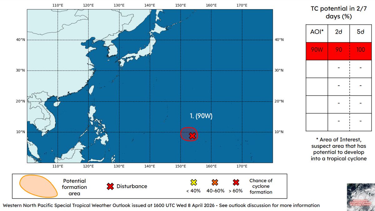
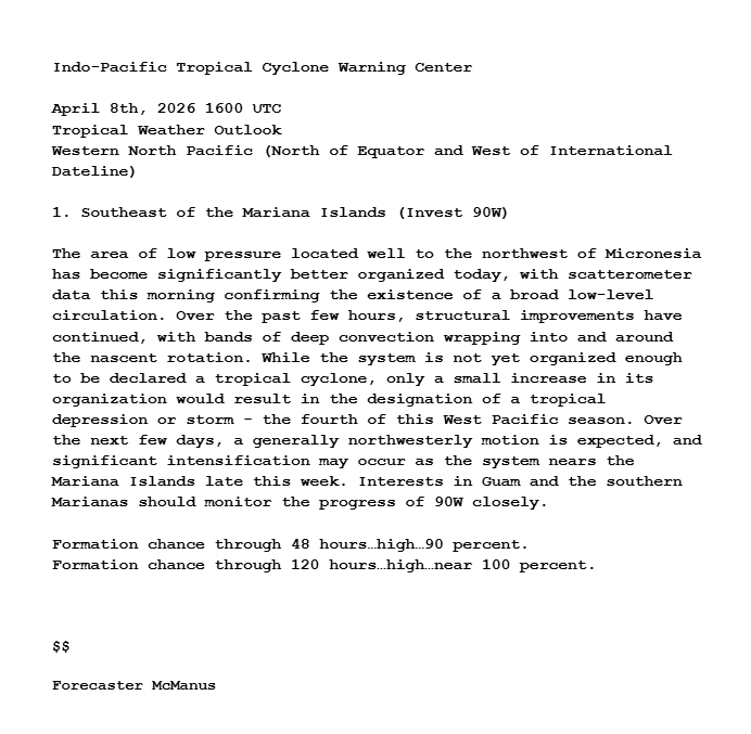
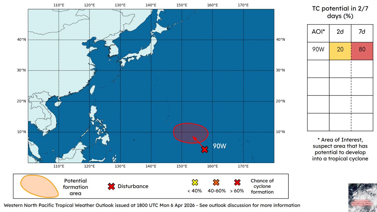
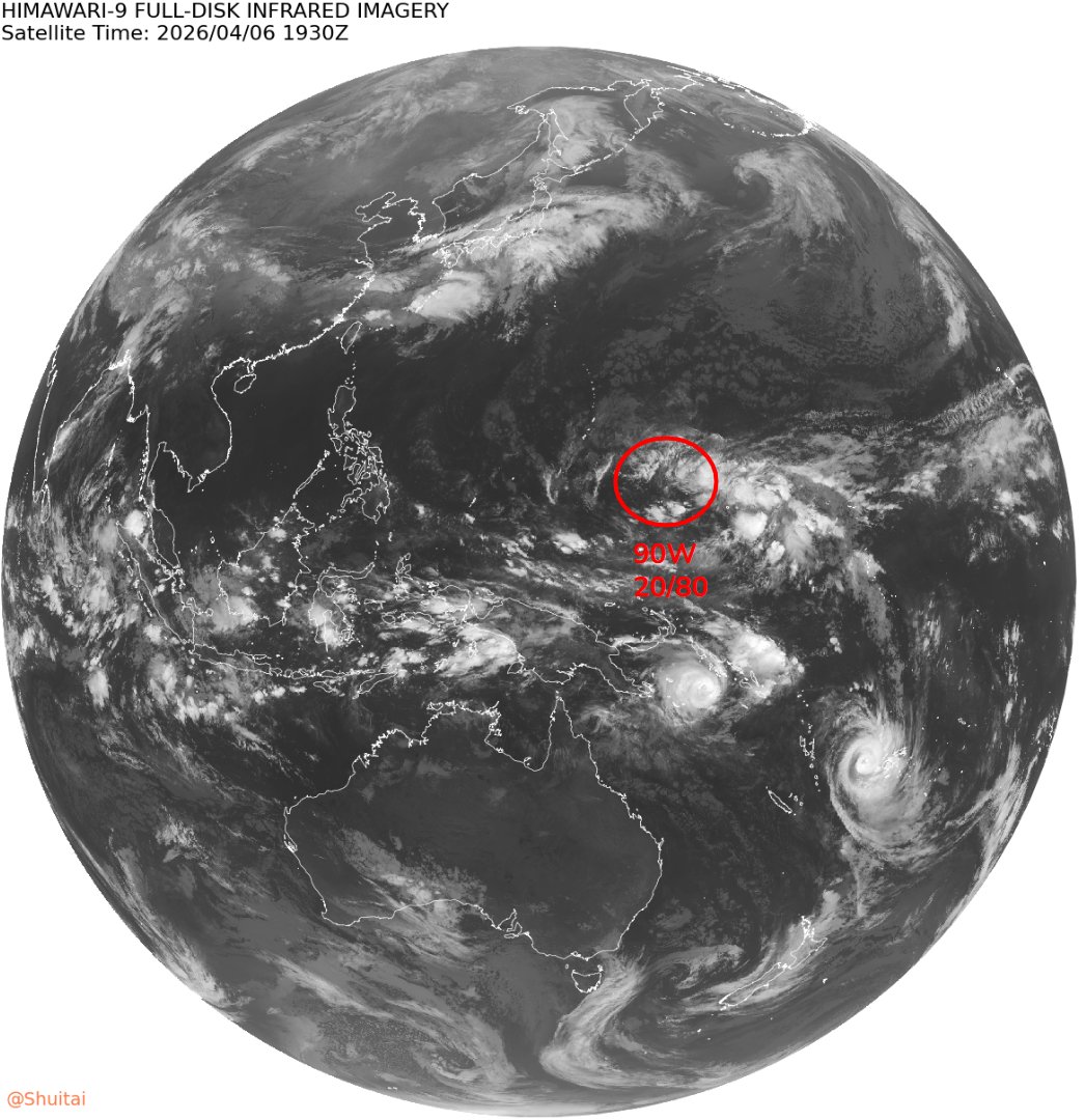
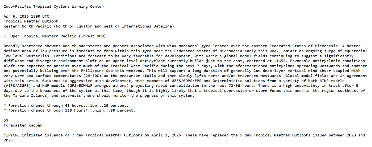
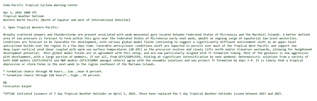
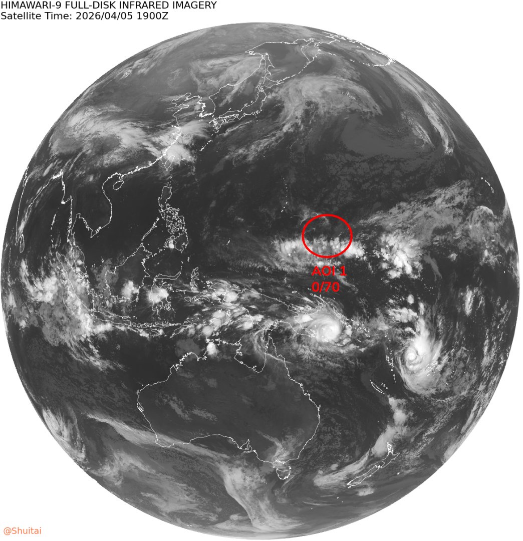
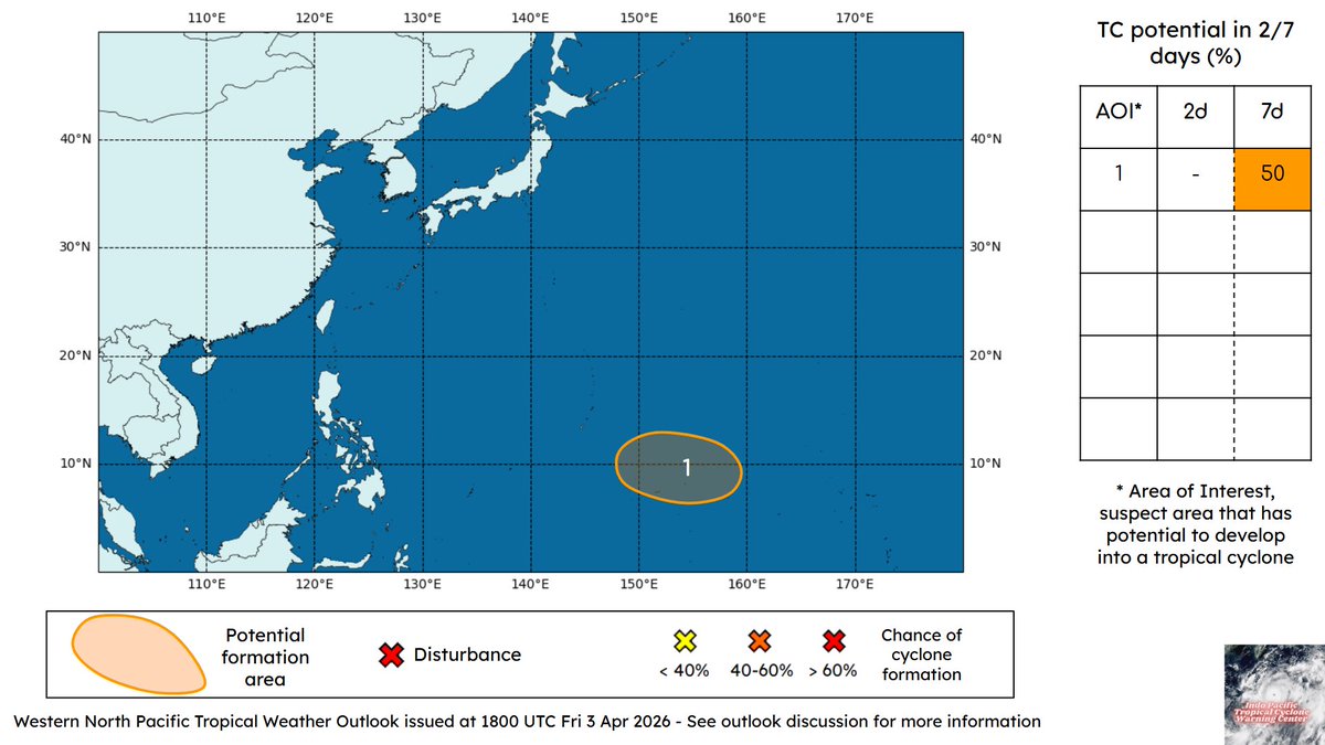
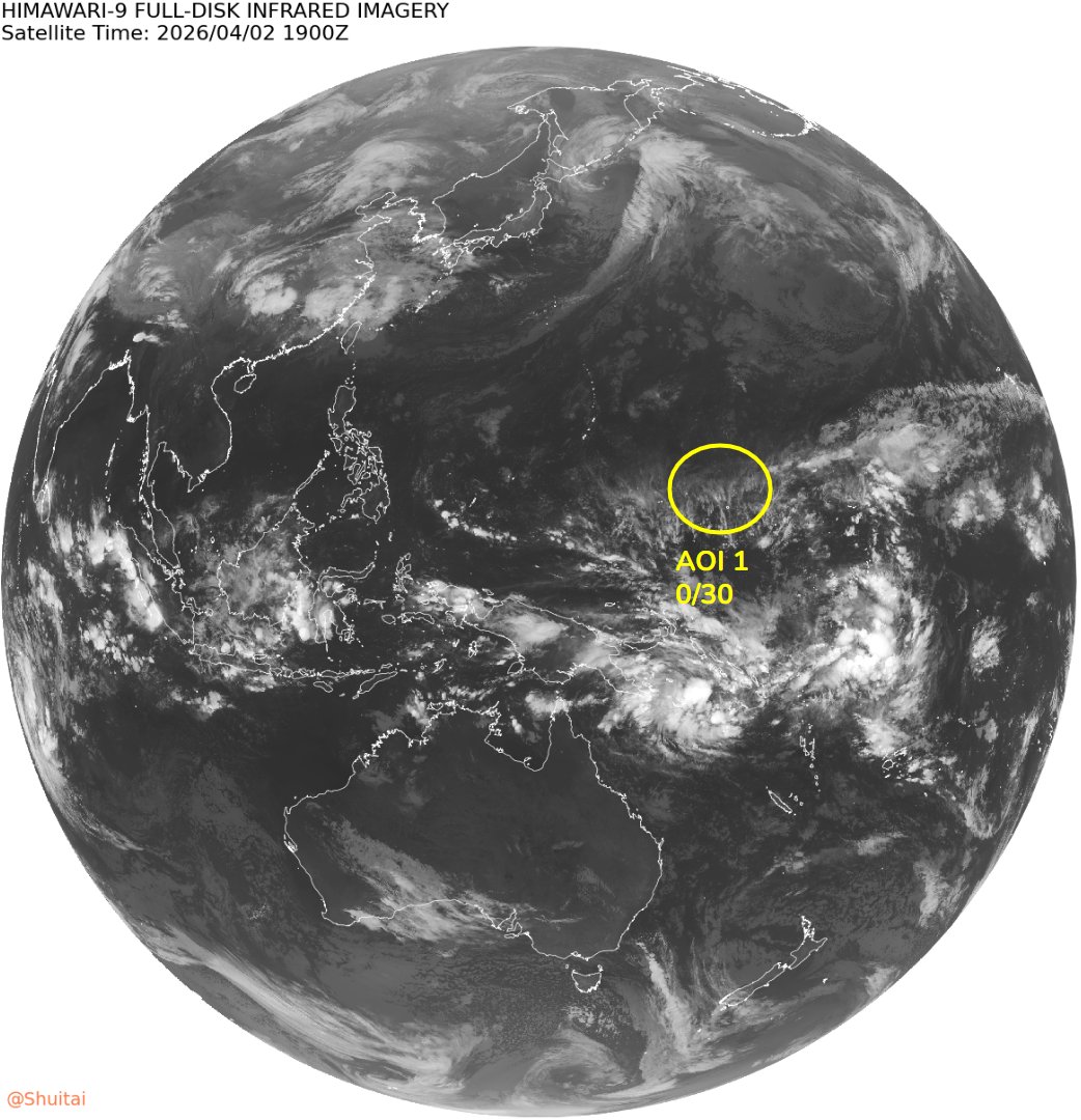
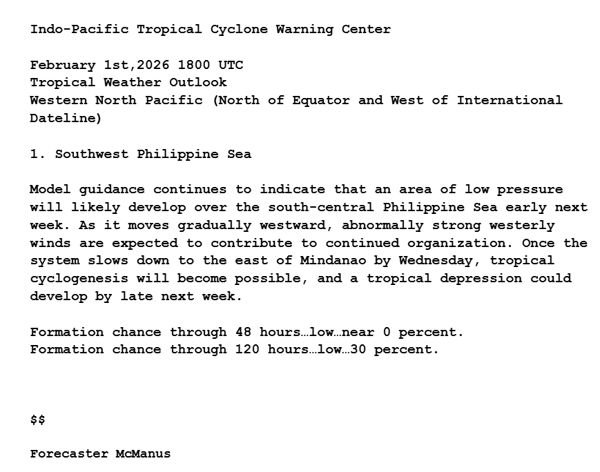
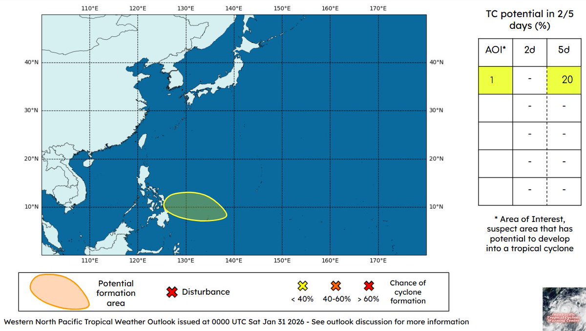
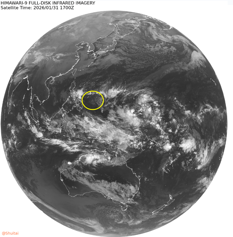
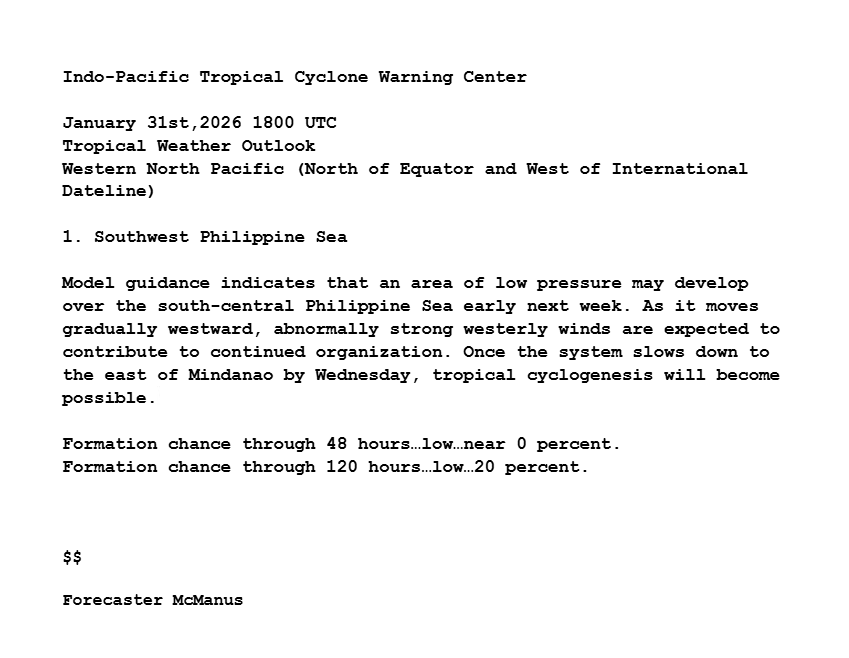
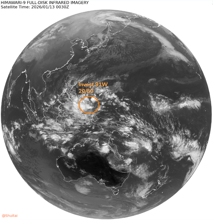
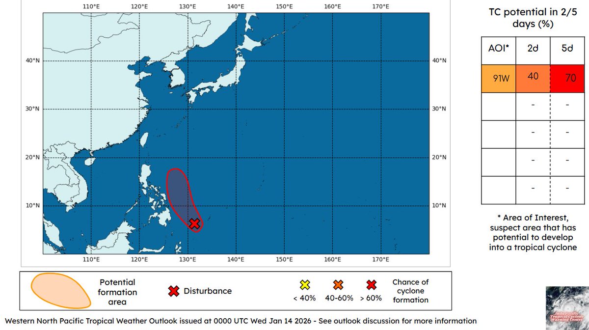
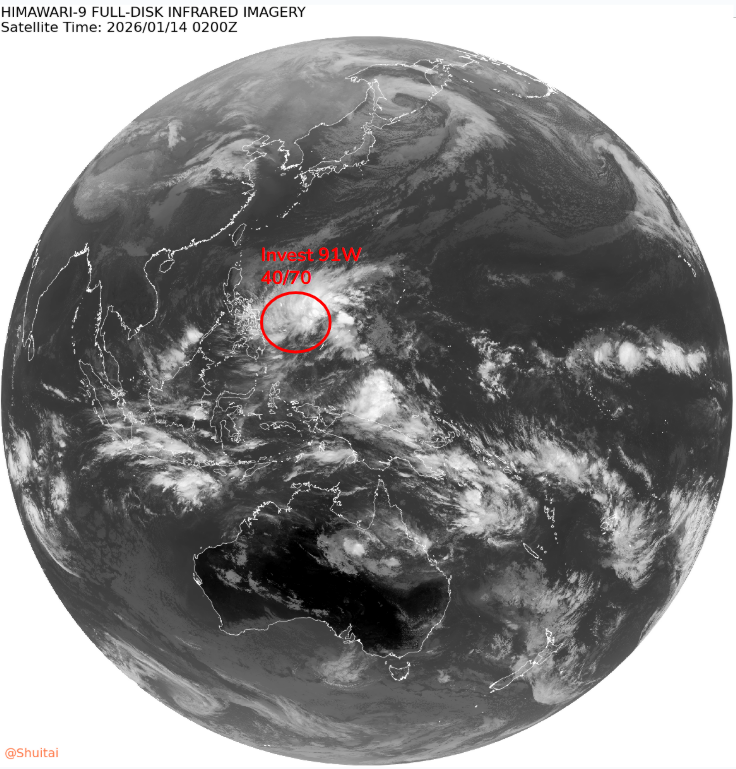
Western North Pacific Tropical Weather Outlook: The area of low pressure (#91W) located east of Mindanao has become better defined today and is likely to develop into a tropical depression or storm by early next week as it tracks northwest towards the central Philippines.
IPTCWC tweet mediaIPTCWC tweet mediaIPTCWC tweet media
English
0
3
5
151
IPTCWC
IPTCWC@IPTCWC·
Western North Pacific Tropical Weather Outlook: An area of low pressure (#91W) located east of Mindanao may develop into a tropical depression or storm by early next week as it tracks northwest, roughly parallelling the Phillipine Islands.
IPTCWC tweet mediaIPTCWC tweet mediaIPTCWC tweet media
English
0
4
6
195