

WeatherMan
1.5K posts

@IndiaWeather12
I love observing clouds.Studying Monsoon patterns ⏳️🌧. Trying to predict unpredictable nature ⛅️. Entrepreneur 🙂 #MumbaiRains #PuneRains | No hype


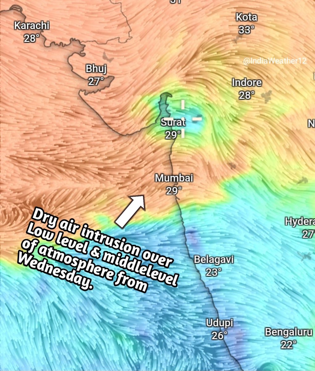
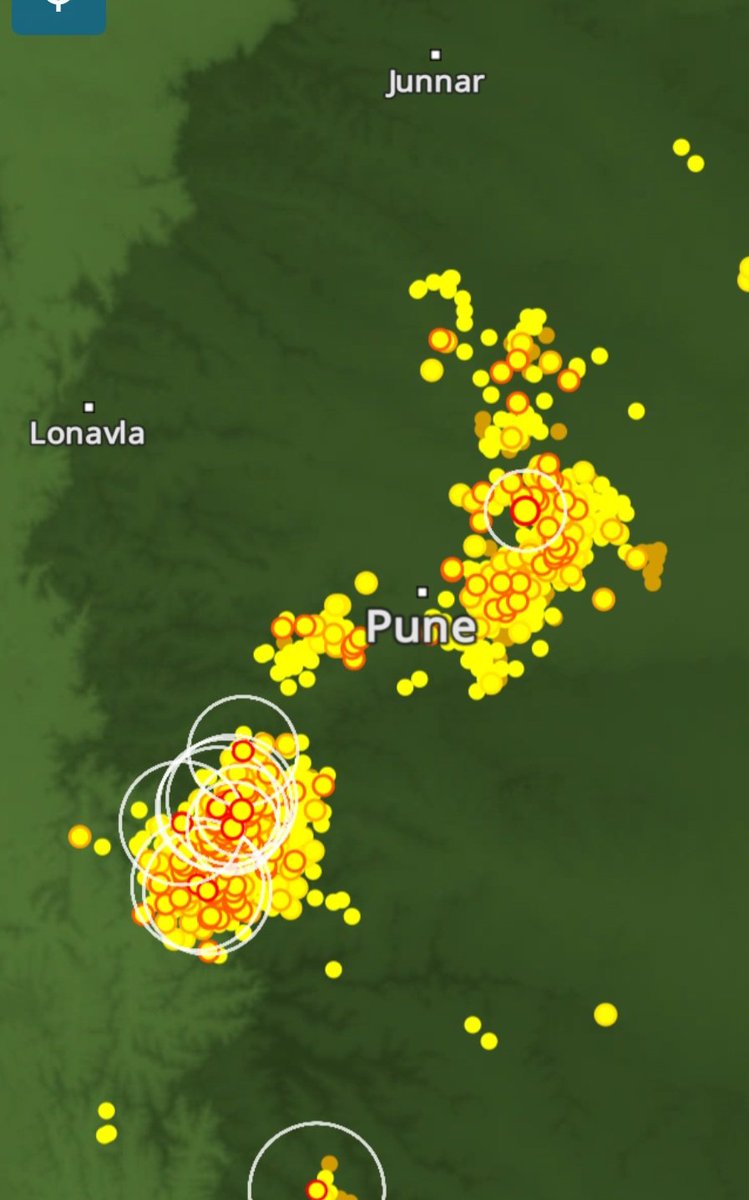
🌧️ Konkan & Western Maharashtra Weather Forecast for next 3 days from (22nd May to 25th May )⛈️🌴 As expected, today we witnessed the first proper low-level cloud chunks developing across the Konkan region ☁️ , indicating increasing low-level moisture due to strengthening westerly winds from the Arabian Sea 🌊🌬️ 🌡️ Temperature Forecast: ▪️ Maximum temperatures across most parts of Interior Konkan & Western Maharashtra are expected to remain between 32°C to 37°C ▪️ Coastal Konkan, including Mumbai, is likely to remain relatively cooler with maximum temperatures between 29°C to 32°C 🌴 With moisture-laden westerlies gradually increasing, humidity levels are also expected to rise noticeably over the coming days 💧🥵 ⛈️ Rainfall Forecast ▪️ Isolated light drizzle or brief showers are possible over parts of Konkan, including Mumbai, especially during early morning hours 🌦️ ▪️ Many places may completely miss rainfall due to the isolated nature of activity ▪️ Hit-or-miss thunderstorm chances also exist, especially over Interior Konkan ⚡ ▪️ Ghats regions & parts of Western Maharashtra including Pune js expected to receive scattered thunderstorms during the next 72 hours ⛈️🌩️. This region will be more favorable for TS activity than Konkan. However, as mentioned earlier, the actual large-scale widespread pre-monsoon thunderstorm activity is still missing and is currently expected to begin after 28th May or during the 1st week of June 🌧️ 🌧️ Monsoon Update: We are still expecting an early arrival of the Southwest Monsoon over Maharashtra 🌴💨 Monsoon onset over Kerala is currently expected sometime next week after 26th May. 🇮🇳🌊


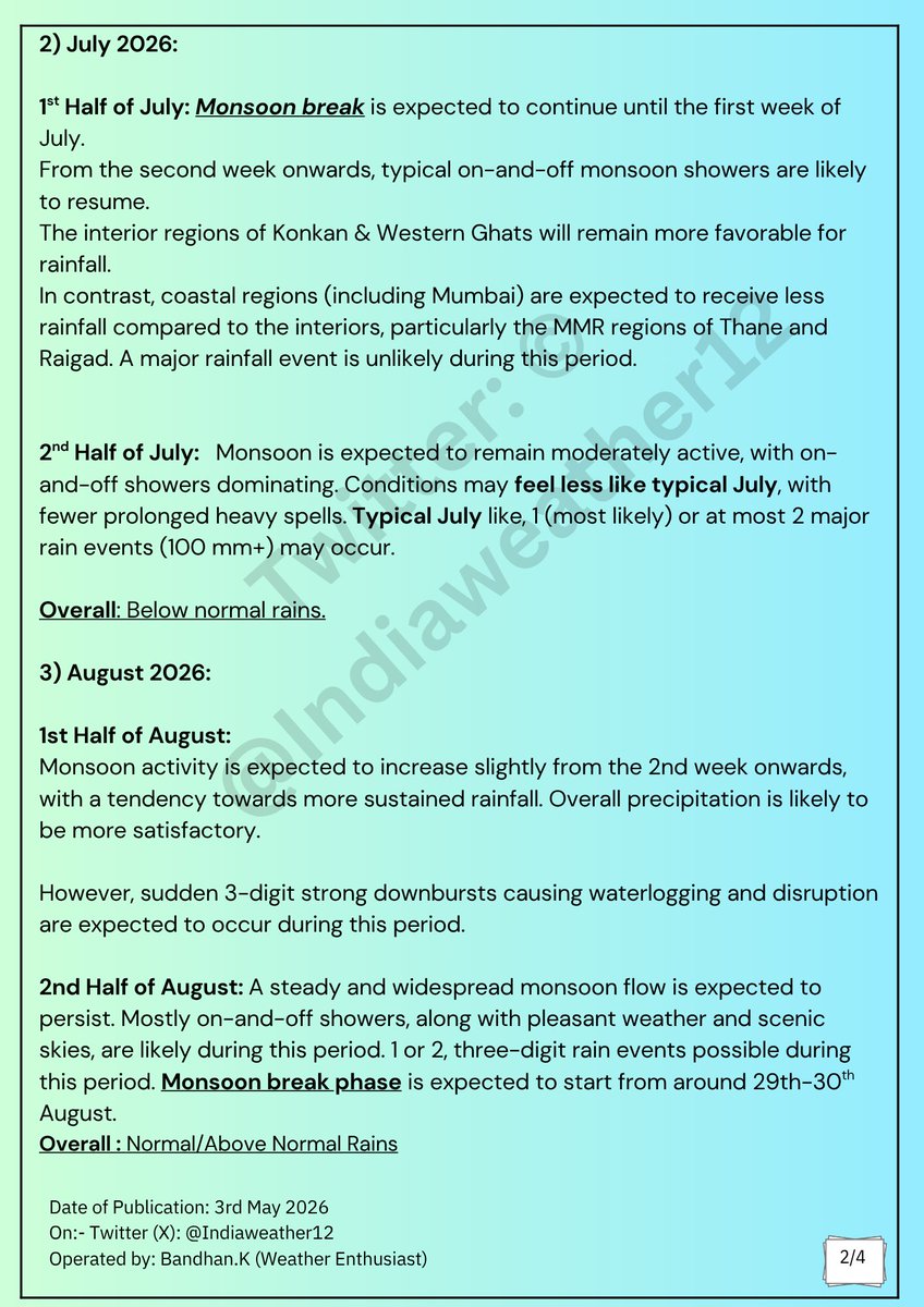
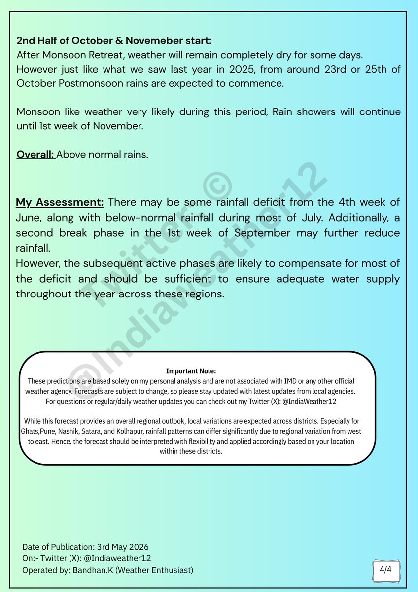
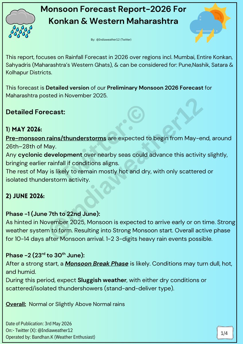
☔️🌧 👉 Detailed Monsoon 2026 Forecast Report for (May-June-July-August-September-October) for entire Konkan Belt incl. (#Mumbai, #Palghar, #Thane, #Raigad, #Ratnagiri, #Sindhudurg) & can be considered for #Pune, #Satara #Nashik #Kolhapur This forecast is Detailed version of our Preliminary Monsoon 2026 Forecast for Maharashtra posted in November 2025. Detailed Forecast: 1) May 2026: Pre-monsoon rains/thunderstorms are expected to begin from May-end, around 26th–28th of May. Any cyclonic development over nearby seas could advance this activity slightly, bringing earlier rainfall if conditions aligns. The rest of May is likely to remain mostly hot and dry, with only scattered or isolated thunderstorm activity. 2) JUNE 2026: Phase -1 (June 7th to 22nd June): As hinted in November 2025, Monsoon is expected to arrive early or on time. Strong weather system to form. Resulting into Strong Monsoon start. Overall active phase for 10-14 days after Monsoon arrival. 1-2 3-digits heavy rain events possible. Phase -2 (23rd to 30th June): After a strong start, a Monsoon Break Phase is likely. Conditions may turn dull, hot, and humid. During this period, expect Sluggish weather, with either dry conditions or scattered/isolated thundershowers (stand-and-deliver type). Overall: Normal or Slightly Above Normal rains 2) July 2026: 1st Half of July: Monsoon break is expected to continue until the first week of July. From the second week onwards, typical on-and-off monsoon showers are likely to resume. The interior regions of Konkan & Western Ghats will remain more favorable for rainfall. In contrast, coastal regions (including Mumbai) are expected to receive less rainfall compared to the interiors, particularly the MMR regions of Thane and Raigad. A major rainfall event is unlikely during this period. 2nd Half of July: Monsoon is expected to remain moderately active, with on-and-off showers dominating. Conditions may feel less like typical July, with fewer prolonged heavy spells. Typical July like, 1 (most likely) or at most 2 major rain events (100 mm+) may occur. Overall: Below normal rains. 3) August 2026: 1st Half of August: Monsoon activity is expected to increase slightly from the 2nd week onwards, with a tendency towards more sustained rainfall. Overall precipitation is likely to be more satisfactory. However, sudden 3-digit strong downbursts causing waterlogging and disruption are expected to occur during this period. 2nd Half of August: A steady and widespread monsoon flow is expected to persist. Mostly on-and-off showers, along with pleasant weather and scenic skies, are likely during this period. 1 or 2, three-digit rain events possible during this period. Monsoon break phase is expected to start from around 29th-30th August. Overall : Normal/Above Normal Rains 4) Septmeber 2026: Phase 1 : Monsoon break phase to continue until around 9th–11th of September. The monsoon trough will remain over the foothills of the Himalayas. Sluggish weather with mostly hot & humid conditions is expected. Scattered/isolated stand-and-deliver thundershowers are expected during this period. Phase-2 : A strong comeback of Monsoon is possible from around 12th–14th September. A strong system is expected to form in the Bay of Bengal (BoB), which will pull the monsoon trough towards central India. This event coincides with Ganesh Utsav, so significant rainfall is likely during the festive days. A very active and wet Monsoon phase is expected. Daily rainfall is likely during this period. 2–3 disruptive, triple-digit heavy rainfall events are possible. Phase 3: From around 27th–28th September, rainfall will start reducing significantly. Rainfall will shift to convective thundershowers. One day of heavy rain during this period cannot be ruled out. Overall: Normal or Above normal rains (due to active 2nd phase) #MumbaiRains #PuneRains #PuneRain #MumbaiRain #MumbaiWeather


🌧️ Konkan & Western Maharashtra Weather Forecast for next 3 days from (22nd May to 25th May )⛈️🌴 As expected, today we witnessed the first proper low-level cloud chunks developing across the Konkan region ☁️ , indicating increasing low-level moisture due to strengthening westerly winds from the Arabian Sea 🌊🌬️ 🌡️ Temperature Forecast: ▪️ Maximum temperatures across most parts of Interior Konkan & Western Maharashtra are expected to remain between 32°C to 37°C ▪️ Coastal Konkan, including Mumbai, is likely to remain relatively cooler with maximum temperatures between 29°C to 32°C 🌴 With moisture-laden westerlies gradually increasing, humidity levels are also expected to rise noticeably over the coming days 💧🥵 ⛈️ Rainfall Forecast ▪️ Isolated light drizzle or brief showers are possible over parts of Konkan, including Mumbai, especially during early morning hours 🌦️ ▪️ Many places may completely miss rainfall due to the isolated nature of activity ▪️ Hit-or-miss thunderstorm chances also exist, especially over Interior Konkan ⚡ ▪️ Ghats regions & parts of Western Maharashtra including Pune js expected to receive scattered thunderstorms during the next 72 hours ⛈️🌩️. This region will be more favorable for TS activity than Konkan. However, as mentioned earlier, the actual large-scale widespread pre-monsoon thunderstorm activity is still missing and is currently expected to begin after 28th May or during the 1st week of June 🌧️ 🌧️ Monsoon Update: We are still expecting an early arrival of the Southwest Monsoon over Maharashtra 🌴💨 Monsoon onset over Kerala is currently expected sometime next week after 26th May. 🇮🇳🌊


🌧️ Konkan & Western Maharashtra Weather Forecast for next 3 days from (22nd May to 25th May )⛈️🌴 As expected, today we witnessed the first proper low-level cloud chunks developing across the Konkan region ☁️ , indicating increasing low-level moisture due to strengthening westerly winds from the Arabian Sea 🌊🌬️ 🌡️ Temperature Forecast: ▪️ Maximum temperatures across most parts of Interior Konkan & Western Maharashtra are expected to remain between 32°C to 37°C ▪️ Coastal Konkan, including Mumbai, is likely to remain relatively cooler with maximum temperatures between 29°C to 32°C 🌴 With moisture-laden westerlies gradually increasing, humidity levels are also expected to rise noticeably over the coming days 💧🥵 ⛈️ Rainfall Forecast ▪️ Isolated light drizzle or brief showers are possible over parts of Konkan, including Mumbai, especially during early morning hours 🌦️ ▪️ Many places may completely miss rainfall due to the isolated nature of activity ▪️ Hit-or-miss thunderstorm chances also exist, especially over Interior Konkan ⚡ ▪️ Ghats regions & parts of Western Maharashtra including Pune js expected to receive scattered thunderstorms during the next 72 hours ⛈️🌩️. This region will be more favorable for TS activity than Konkan. However, as mentioned earlier, the actual large-scale widespread pre-monsoon thunderstorm activity is still missing and is currently expected to begin after 28th May or during the 1st week of June 🌧️ 🌧️ Monsoon Update: We are still expecting an early arrival of the Southwest Monsoon over Maharashtra 🌴💨 Monsoon onset over Kerala is currently expected sometime next week after 26th May. 🇮🇳🌊