Jake Parrish
7.1K posts
Jake Parrish
@JParrishWX
AP Award winning Meteorologist, @redcross Disaster Action Team, volunteer fire, @spectrumnews1tx freelance met, @imfletchcast co-host. Runner, CF. Based in ATX.
Austin, TX Katılım Aralık 2011
1.7K Takip Edilen2.2K Takipçiler

Looking iffy for the eclipse…#txwx
NWS Austin/San Antonio@NWSSanAntonio
Here is the eclipse cloud cover forecast as of April 4th. There has been little change in the forecast, with mostly cloudy skies anticipated across south-central Texas. Continue to check back for updates as the forecast evolves. #Eclipse2024 #txwx
English
@DailyDoseOfTron If Encom is in the movie, how could we not see Alan and Sam?
English

BREAKING: FIRST LOOK AT JARED LETO AS ARES ON-SET
English
Jake Parrish retweetledi
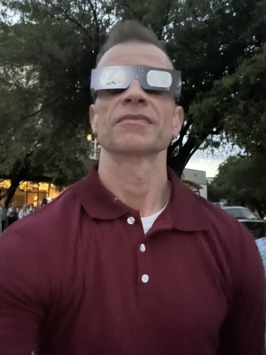
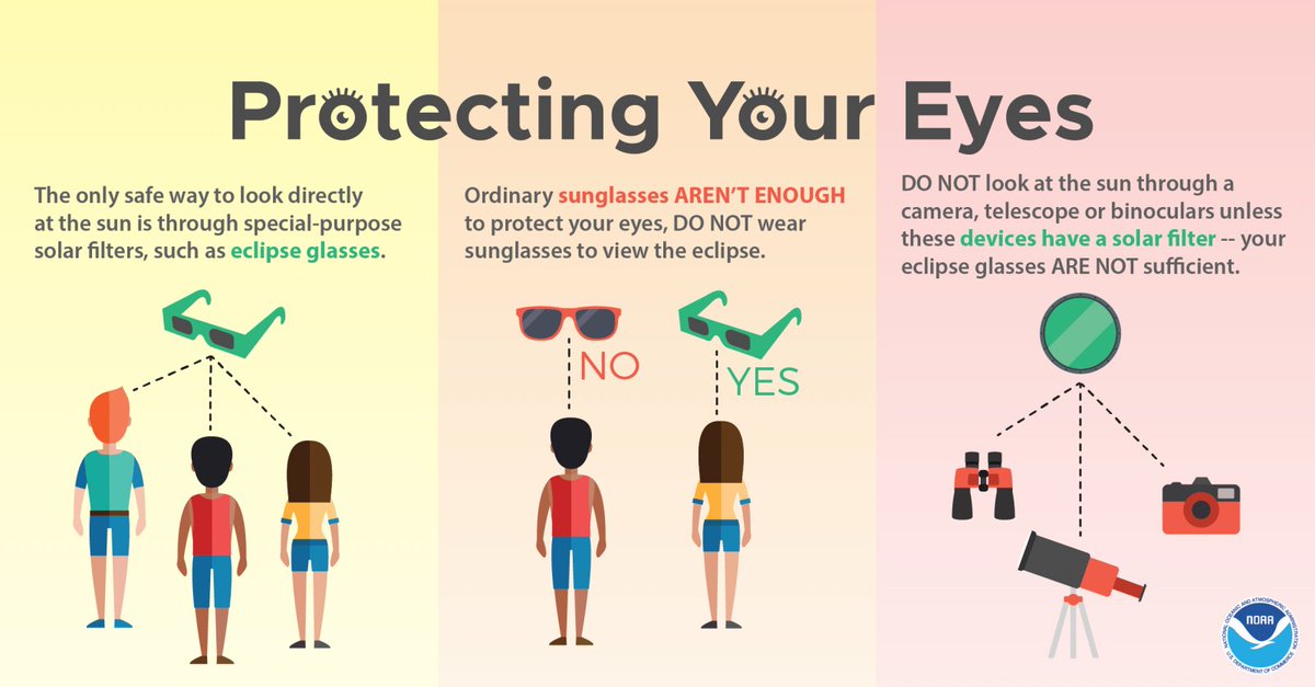
We are officially one month away from a total solar eclipse happening on April 8th, 2024. Now is the time to find eclipse glasses to make sure you're ready! Remember, ordinary sunglasses are not enough to protect your eyes when viewing before totality is reached. #txwx
English

Ugh, just ran in this cold. @3mhalfmarathon next weekend looks warmer, thank goodness. Stay safe! #txwx
NWS Austin/San Antonio@NWSSanAntonio
The previously issued Wind Chill Advisory has been extended through Wednesday morning, and a Hard Freeze Warning has been issued to complement it. We've also attached the forecast minimum temperature and wind chill graphics for Monday morning (MLK Day). #txwx
English
1/14/24 update: Icing possible late Sunday into Monday morning. Wind Chill Advisory active during that time as well. Stay alert! #txwx
NWS Austin/San Antonio@NWSSanAntonio
Winter Weather Advisory now in effect from 6 pm Sun to Noon Mon. Ice Accumulations from 0.01-0.10" possible, mainly on bridges, overpasses, and elevated surfaces. Plan accordingly.
English
Update 1/13/24 on upcoming cold/ice potential. Stay safe! #txwx
NWS Austin/San Antonio@NWSSanAntonio
At least the daytime temperatures will be nice today. Tonight an arctic air surge is set to arrive. Wind chills late tonight could fall into the teens. Freezing rain is possible Sunday night into Monday. Prepare the four "P"s for hard freezes for 3-4 days in a row.
English
Strong front late Sunday, 1/14/24 #txwx
NWS Austin/San Antonio@NWSSanAntonio
Confidence continues to increase that the strongest front of the season will arrive Sunday night. There is a 20-30% chance that highs Monday could stay below freezing and high probabilities that lows Tuesday morning will be below 25 degrees for much of the area.
English
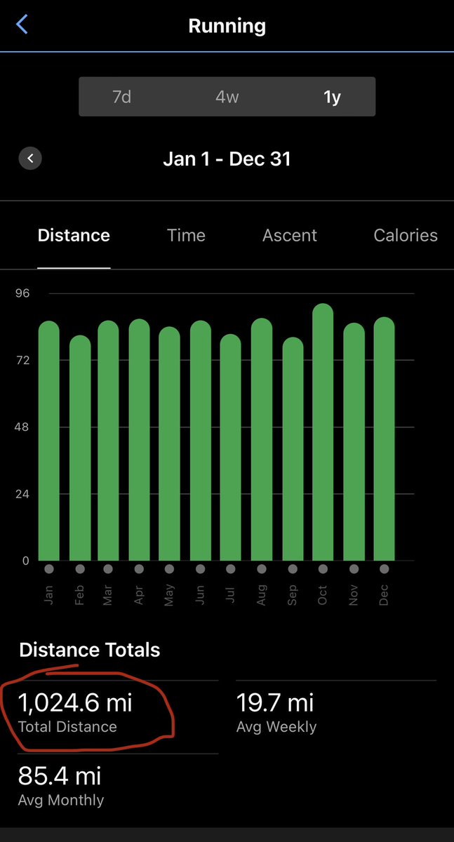
Goal of running 1,000+ miles in 2023 accomplished! 🤞for more in 2024!
English
Cold Monday morning 12/11/23, for central Texas! #txwx
NWS Austin/San Antonio@NWSSanAntonio
A Freeze Warning has been issued for portions of South Central Texas tonight into Monday morning. Some locations, especially city centers, may not reach the 32 degree mark, but plan accordingly it will still be colder than we have seen in a while! #txwx
English

FYI for Thursday, November 30th, 2023. #txwx
NWS Austin/San Antonio@NWSSanAntonio
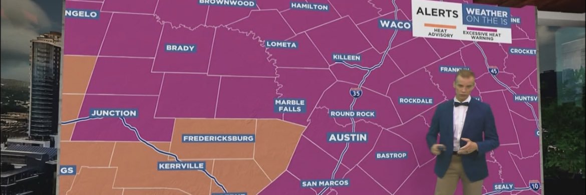
Midday update: The tornado risk has shifted slightly east, with a maximum level 2 of 5 threat now in south-central Texas. People in the dark green and yellow shaded areas should be prepared in case warnings are issued, with the highest risk along US-77 between 8a-2p.
English
You won’t find a better human than @hwinkler4real. Just finished his new book, highly recommended!

English

English

Best pace in - maybe 3 years ? Assists to @ChadLavenderMD @GenerationsPT @SnapFitnessWV for great health care management and moral support and shout out to #CommonSense … had to learn to stay off this knee for longer between sessions. “Arthur” trying to drag me down - but still fighting. Now if I’d stop eating junk food … 🤭🤷🏻♂️😄

English