Michigan Storm Chasers
7.9K posts

Michigan Storm Chasers
@MiStormChasers
Michigan's #1 Storm Chasing & Live Coverage Team. Providing the Great Lake State with accurate forecasts, live chasing, weather education, and disaster relief.
Michigan, USA Katılım Mayıs 2021
198 Takip Edilen21.8K Takipçiler

The UV index is quite high this week and it is important to recognize the dangers of what that means for your skin. Increased risk of heat stroke, along with faster sunburn times are the main concerns. Limit sun exposure as best as possible, and lather on the sunscreen if you plan to spend prolonged periods outdoors.

English

⚠️ A string of wildfires began earlier this afternoon, stretching from the Minnesota border up to the north of Lake Nipigon in Ontario, Canada. This sudden area of wildfires may result in hazier and smokier skies over the next 3-5 days as the high pressure system spins clockwise off to our southwest, allowing for continuous flow to bring smoke southward into Michigan.
This is brand new development, and we continue to monitor potential impacts around the region. This could make going outside over the next several days extremely hazardous due to the combination of poor air quality, and excessive heat with temperatures around 100°F. Upper Peninsula and Isle Royale residents will be the most at-risk.
Post as of 8:20 pm EDT 7/13/26.
English

While Michigan has had an above average year for tornadoes at 23 overall, Illinois and Indiana have seen record settings years. Illinois alone has had 178 tornadoes this year, and Indiana has 76.
While 23 tornadoes is nothing to take lightly, we are certainly thankful we aren't like our neighbors to the south.

English

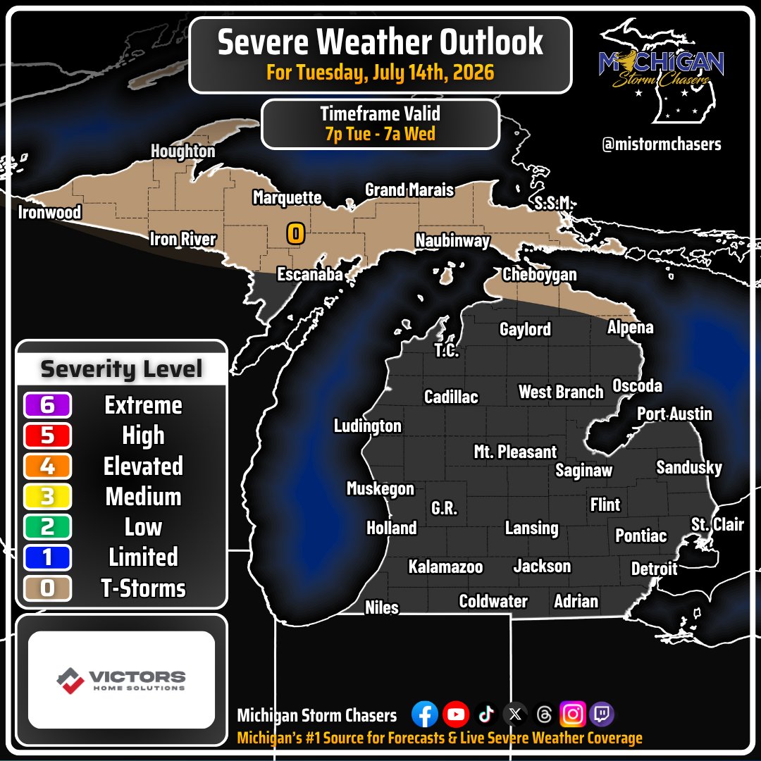
Tomorrow evening 7/14/26, a back door cold front will be swooping in from the north, similar to what we saw yesterday. A line of broken showers and storms may develop, but not hit everyone in the tan-shaded thunderstorm zone. While there is a slight increase in wind shear along the front, all severe hazards have a 1% chance of occurring or less. Timing for showers and storms will be primarily after 7 pm EDT tomorrow through 7 am EDT Wednesday morning.
Cold front is a loose term here in the middle of a heat wave, as temperatures will very briefly drop by 5-10°F before rebounding during peak heating hours on Wednesday.
-- Trusted Partner of the Day --
Victors Home Solutions | From our free 21-Point Roof Inspection to our 50-Year Leak Free Guarantee, we’ll protect your home and family for years to come. With two decades of roofing experience and a BBB Accredited A+ rating, Victors Home Solutions is the superior roofing company across Michigan, Ohio, Kentucky, and Indiana. We provide the highest quality workmanship for residential roof repairs and replacements, seamless gutters, and attic insulation services. Call us today at 866-376-3883 to schedule your free roof inspection.

English

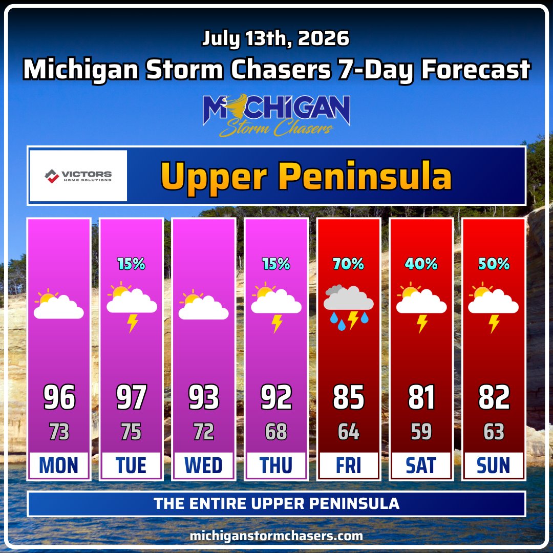
Two days of mugginess today and tomorrow, then some Arizona heat as we move beyond Tuesday. Here are your 7-day outlooks across Michigan divided into four areas. A reminder that the temperatures shown are averaged across the entire area. We only wish we had the power to create 3,000 graphics for every city and town.
Air temperatures in the 90s and 100s for most between now and Thursday, with overnight lows in the 70s. We trend to near normal again as we head into the weekend, with increasing shower and storm chances. A few storms may be severe, but we won't know how severe until we get through the next couple of days.
Enjoy the heat, but make sure to take preventative measures to avoid heat-related illnesses.
-- Trusted Partner of the Day --
Victors Home Solutions | From our free 21-Point Roof Inspection to our 50-Year Leak Free Guarantee, we’ll protect your home and family for years to come. With two decades of roofing experience and a BBB Accredited A+ rating, Victors Home Solutions is the superior roofing company across Michigan, Ohio, Kentucky, and Indiana. We provide the highest quality workmanship for residential roof repairs and replacements, seamless gutters, and attic insulation services. Call us today at 866-376-3883 to schedule your free roof inspection.


English

Today marks the beginning of another round of hotter and more humid conditions across the state. The worst of today's heat will be found in Michigan's Upper Peninsula along with northern lower, where the heat index may top 105F in some areas. This has the NWS heat risk in Major to even Extreme levels. Each level has different meanings which are listed below. Stay cool, hydrated, and plan for a few more days of these conditions ahead.
Green 0 Little to no risk from expected heat.
Yellow 1 Minor - Primarily affects those who are extremely sensitive to heat and without cooling/hydration.
Orange 2 Moderate - Affects those who are sensitive to heat, especially those without cooling/hydration, and some health systems and industries.
Red 3 Major - Affects anyone without cooling/hydration as well as health systems and industries.
Magenta 4 Extreme - Rare and/or long-duration extreme heat with no overnight relief affecting anyone without cooling/hydration as well as health systems, industries, and infrastructure.

English

Today's heat index across the state will be elevated, with the UP seeing the worst conditions. Further south, today is a bit cooler, but that will change tomorrow & Wednesday as hotter conditions push south. We will take a look at tomorrow's heat index later this evening. In the meantime, stay cool, stay hydrated, check on the vulnerable, and bring pets indoors.

English

Michigan Severe Weather Coverage - July 13th, 2026 x.com/i/broadcasts/1…
English

Severe Thunderstorm Warning for Cheboygan, Montmorency, and Presque Isle County in MI until 3:45am EDT. #miwx
English

Severe Thunderstorm Warning for Dickinson, Marquette, and Menominee County in MI until 5:15pmCDT/6:15pmEDT. #miwx
English

Severe Thunderstorm Warning for Dickinson and Marquette County in MI until 4:45pmCDT/5:45pmEDT. #miwx
English