Muskoka GIS

1.1K posts

Muskoka GIS banner
Muskoka GIS

Muskoka GIS

@MuskokaGIS

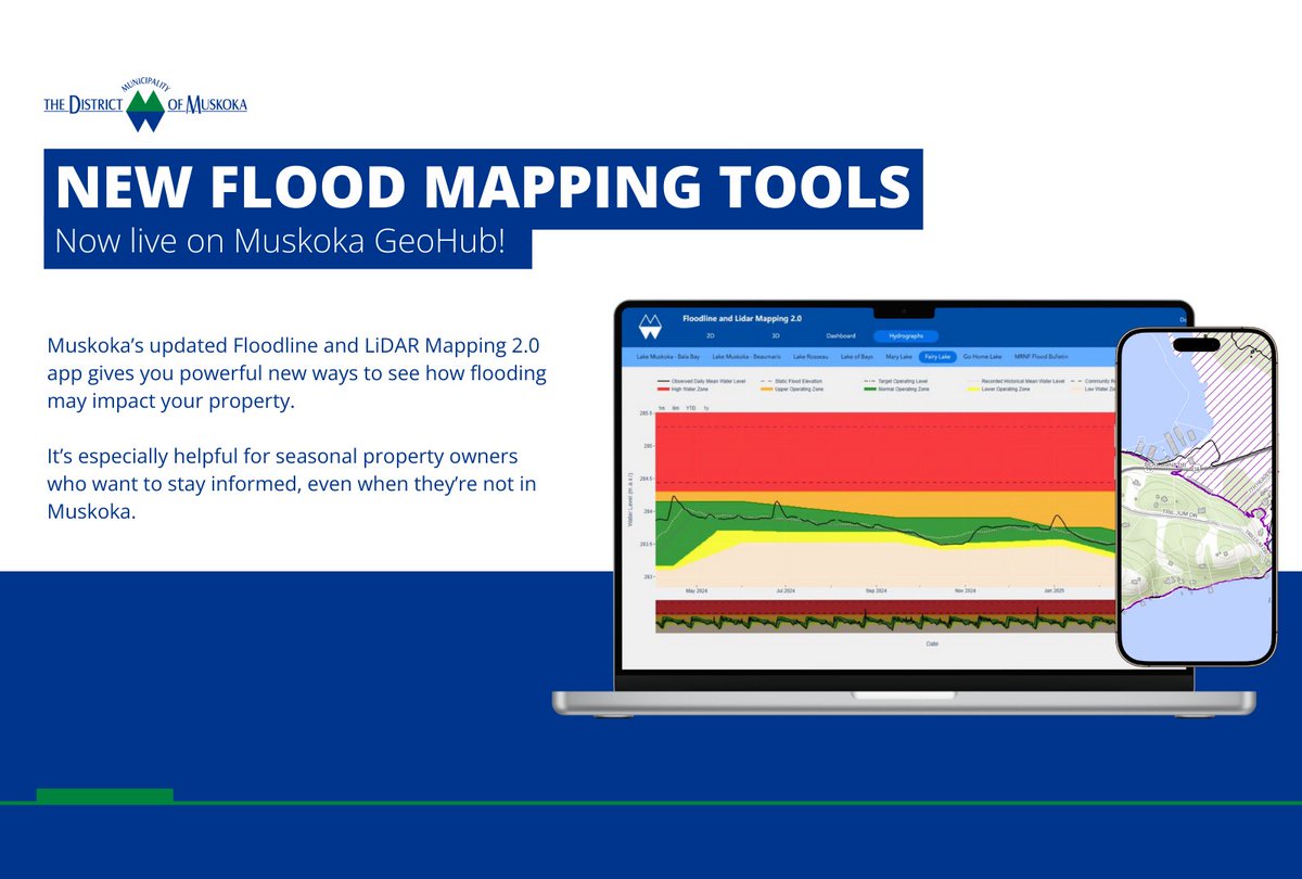
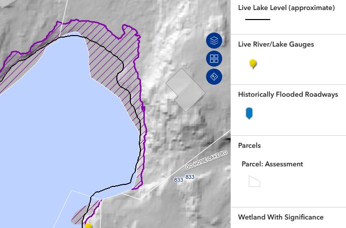
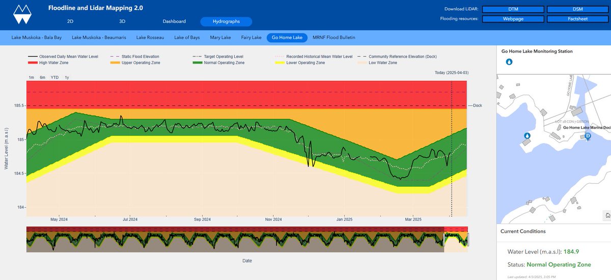
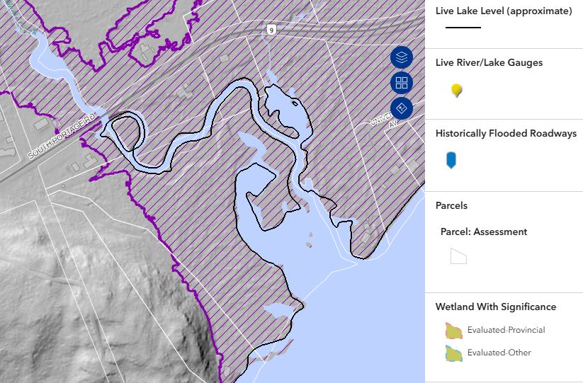
The District of Muskoka GIS department. GIS = Geographic Information Systems = MAPS! Visit our GeoHub page for lots of cool maps, apps, and open data.

Muskoka, Ontario, Canada Katılım Eylül 2013
510 Takip Edilen603 Takipçiler
Muskoka GIS
Muskoka GIS@MuskokaGIS·
Citizens of Muskoka are heading to the polls Monday October 26, 2026! Use the #Muskoka #Votes app to search for your municipality/ward and see the candidates who are running! map.muskoka.on.ca
Muskoka GIS tweet media
English
0
0
1
31
Muskoka GIS
Muskoka GIS@MuskokaGIS·
We just added the elevation profile tool to the Topo #Map, which shows the ground, and all above ground features in two separate line styles. Try it out on the #Muskoka #GeoHub map.muskoka.on.ca
Muskoka GIS tweet media
English
0
0
3
260
Muskoka GIS
Muskoka GIS@MuskokaGIS·
Muskoka GeoHub's updated Floodline and LiDAR Mapping 2.0 app gives you powerful new ways to see how flooding may impact your property. It’s especially helpful for seasonal property owners who want to stay informed, even when they’re not in Muskoka. map.muskoka.on.ca
Muskoka GIS tweet media
English
0
4
10
1.9K
Muskoka GIS retweetledi
District of Muskoka
District of Muskoka@DistrictMuskoka·
🌊 New Flood Mapping Tools Now Live on Muskoka GeoHub! Muskoka’s updated Floodline and LiDAR Mapping 2.0 app gives you powerful new ways to see how flooding may impact your property. It’s especially helpful for seasonal property owners who want to stay informed, even when they’re not in Muskoka. Here’s what’s new: ✅ Explore flood-prone areas in 2D and 3D ✅ See live lake levels, now updated hourly ✅ Use the new Live Lake Level Line to see where water may reach on your property – now available along with detailed hydrographs for these 7 lakes across Muskoka with live monitoring: (Bala Bay, Fairy Lake, Go Home Lake, Lake Muskoka, Lake of Bays, Lake Rosseau and Mary Lake) ✅ Filter data by structure, municipality, or lake to see affected areas and estimated values ➡ Explore the new features now at: muskoka.cc/GHFloodplainMa… ➡ Need help getting started? Watch our YouTube tutorial: youtu.be/FllX-SY1dLs ➡ View all of GeoHub’s apps at: map.muskoka.on.ca #MuskokaGeoHub #FloodMapping #LiveLakeLevels #LiDAR #LakeMuskoka #BalaBay #FairyLake #GoHomeLake #LakeofBays #LakeRosseau #MaryLake #FloodAwareness #CottageCountry #Muskoka #MuskokaGeoHub @Gateway2Muskoka @townbracebridge @LakeofBaysTwp @townhuntsville @gbtownship @MuskokaLakesTwp @MuskokaGIS
YouTube video
YouTube
District of Muskoka tweet media
English
0
4
1
466
Muskoka GIS
Muskoka GIS@MuskokaGIS·
Muskoka Geohub Users: Our public GeoHub website host is experiencing technical issues this morning making it intermittently inaccessible. This is outside of our control, and we are waiting for the fix to come through. Sorry for the inconvenience.
English
0
0
0
78
Muskoka GIS
Muskoka GIS@MuskokaGIS·
The #Muskoka #GeoHub has new floodwater features! The Floodline and Lidar app now shows live lake level lines for Go Home Lake, updated hourly, and the hydrograph tab shows the current level compared to operating zones with 20yrs data! map.muskoka.on.ca #gohomelake
Muskoka GIS tweet mediaMuskoka GIS tweet media
English
0
0
1
77
Muskoka GIS
Muskoka GIS@MuskokaGIS·
The #Muskoka #GeoHub has new floodwater features! The Floodline and Lidar app now shows live lake level lines for Lake of Bays, updated hourly, and the hydrograph tab shows the current level compared to operating zones with 20yrs data! map.muskoka.on.ca #lakeofbays
Muskoka GIS tweet mediaMuskoka GIS tweet media
English
0
0
1
67
Muskoka GIS
Muskoka GIS@MuskokaGIS·
The #Muskoka #GeoHub has new floodwater features! The Floodline and Lidar app now shows live lake level lines for 7 major lakes, updated hourly, and the hydrograph tab shows the current level compared to operating zones with 20yrs data! map.muskoka.on.ca @MuskokaLakes
Muskoka GIS tweet mediaMuskoka GIS tweet media
English
0
0
1
55
Muskoka GIS
Muskoka GIS@MuskokaGIS·
The #Muskoka #GeoHub has new floodwater features! The Floodline and Lidar app now shows live lake level lines for Mary Lake, updated hourly, and the hydrograph tab shows the current level compared to operating zones with 20yrs data! map.muskoka.on.ca @MaryLakeAssoc
Muskoka GIS tweet mediaMuskoka GIS tweet media
English
0
1
1
104
Muskoka GIS
Muskoka GIS@MuskokaGIS·
The #Muskoka #GeoHub has new floodwater features! The Floodline and Lidar app now shows live lake level lines for 7 major lakes, updated hourly, and the hydrograph tab shows the current level compared to operating zones with 20yrs data! map.muskoka.on.ca @DistrictMuskoka
Muskoka GIS tweet mediaMuskoka GIS tweet media
English
0
0
2
90
Muskoka GIS retweetledi
MuskokaWatershedCncl
MuskokaWatershedCncl@muskokawatershd·
Happy International Day of Women and Girls in Science! 👩‍🔬🌍 This day celebrates the valuable contributions of women, girls and youths in science. We would like to recognize Christiane Masters, a District of Muskoka employee who analyzes water samples from all around Ontario!
MuskokaWatershedCncl tweet media
English
0
1
3
150
Muskoka GIS retweetledi
Esri Canada
Esri Canada@esricanada·
Save the Date - The Esri Canada User Conference is back! When: November 3–4, 2025 Where: Toronto, Ontario More details coming soon—stay tuned! #EsriCanadaUC #GISCommunity #SaveTheDate
Esri Canada tweet media
English
0
2
4
311
Muskoka GIS retweetledi
Muskoka Paramedics
Muskoka Paramedics@MuskokaPS·
Does your 911 sign look like this right now? Have a look and make sure it's clear so Paramedics and other responders can get to you in an emergency. #Snowfall #snow #Muskoka
Muskoka Paramedics tweet media
English
0
10
14
2.4K