NWS GSP

54.2K posts

NWS GSP banner
NWS GSP

NWS GSP

@NWSGSP

Official X Account for National Weather Service Greenville-Spartanburg, SC. Details: https://t.co/2JyXqeajGw.

Greer, SC Katılım Haziran 2012
462 Takip Edilen36.6K Takipçiler
NWS GSP
NWS GSP@NWSGSP·
A special weather statement has been issued for Weaverville NC, Mars Hill NC and Marshall NC until 7:45 PM EDT
NWS GSP tweet media
English
0
0
1
165
NWS GSP
NWS GSP@NWSGSP·
A special weather statement has been issued for Sylva NC, Webster NC and Dillsboro NC until 7:45 PM EDT
NWS GSP tweet media
English
0
0
1
217
NWS GSP
NWS GSP@NWSGSP·
A special weather statement has been issued for Canton NC, West Canton NC and Cruso NC until 7:30 PM EDT
NWS GSP tweet media
English
0
1
0
468
NWS GSP
NWS GSP@NWSGSP·
A special weather statement has been issued for Mocksville NC, Bermuda Run NC and Advance NC until 7:30 PM EDT
NWS GSP tweet media
English
0
0
1
508
NWS GSP
NWS GSP@NWSGSP·
A special weather statement has been issued for Statesville NC and Love Valley NC until 6:45 PM EDT
NWS GSP tweet media
English
0
0
4
682
NWS GSP
NWS GSP@NWSGSP·
A special weather statement has been issued for Burnsville NC, Celo NC and Micaville NC until 6:30 PM EDT
NWS GSP tweet media
English
0
0
3
740
NWS GSP
NWS GSP@NWSGSP·
A Flood Advisory is in effect for the following areas through 08:15 PM: Caldwell-NC
NWS GSP tweet media
English
0
0
2
850
NWS GSP
NWS GSP@NWSGSP·
A special weather statement has been issued for Celo NC until 5:45 PM EDT
NWS GSP tweet media
English
0
0
0
770
NWS GSP
NWS GSP@NWSGSP·
A special weather statement has been issued for Crossnore NC until 5:45 PM EDT
NWS GSP tweet media
English
0
0
2
769
NWS GSP
NWS GSP@NWSGSP·
A tropical system does not have to reach hurricane strength to be deadly. Tropical storms can produce strong winds and tornadoes, as well as heavy rainfall, which can lead to flooding. For more information about tropical storms and hurricanes, visit weather.gov/safety/hurrica…
NWS GSP tweet media
English
0
0
4
785
NWS GSP
NWS GSP@NWSGSP·
A Flood Advisory is in effect for the following areas through 07:45 PM: Caldwell-NC
NWS GSP tweet media
English
0
0
2
866
NWS GSP
NWS GSP@NWSGSP·
Severe Thunderstorm Warning including Collettsville NC until 5:15 PM EDT
NWS GSP tweet media
English
0
0
1
840
NWS GSP
NWS GSP@NWSGSP·
A special weather statement has been issued for Lenoir NC, Sawmills NC and Gamewell NC until 5:00 PM EDT
NWS GSP tweet media
English
0
0
0
862
NWS GSP
NWS GSP@NWSGSP·
Severe Thunderstorm Warning including Lenoir NC, Gamewell NC and Cedar Rock NC until 4:15 PM EDT
NWS GSP tweet media
English
0
0
1
932
NWS GSP
NWS GSP@NWSGSP·
A special weather statement has been issued for Marion NC, West Marion NC and Glenwood NC until 3:45 PM EDT
NWS GSP tweet media
English
0
0
0
880
NWS GSP
NWS GSP@NWSGSP·
A special weather statement has been issued for Etowah NC, Mills River NC and Horse Shoe NC until 3:00 PM EDT
NWS GSP tweet media
English
0
0
2
1K
NWS GSP
NWS GSP@NWSGSP·
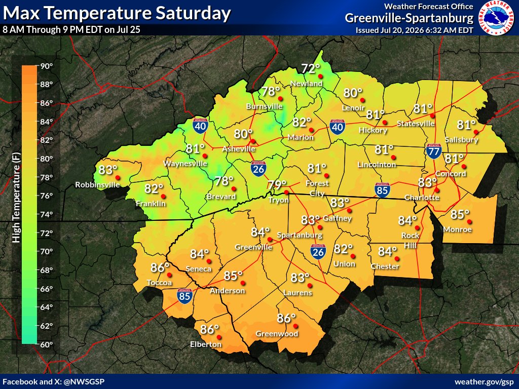
😍Much needed relief from the heat and humidity is on the way! 🆒Cooler and below normal high temperatures return starting Thursday and linger through at least Saturday. #ncwx #scwx #gawx
NWS GSP tweet mediaNWS GSP tweet mediaNWS GSP tweet media
English
0
3
12
1.2K
NWS GSP
NWS GSP@NWSGSP·
ON THIS DATE, 28 YEARS AGO: A 2nd day of severe storms produced wind damage, including a damaging wind gust that injured two people. A cluster of storms moved slowly across the Charlotte area, producing intense lightning that damaged or destroyed 15 dwellings. #scwx #ncwx #gawx
NWS GSP tweet media
English
0
0
11
1.4K
NWS GSP
NWS GSP@NWSGSP·
Hot but not quite as humid today. Highs in the low to mid 90s outside of the mountains, with the heat index around 100 along and south of the I-85 corridor. Scattered thunderstorms again this afternoon. A few may become severe with damaging winds. #ncwx #scwx #gawx
NWS GSP tweet mediaNWS GSP tweet media
English
0
1
12
1.4K