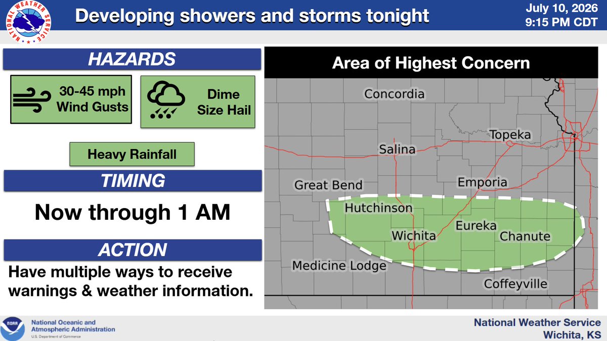
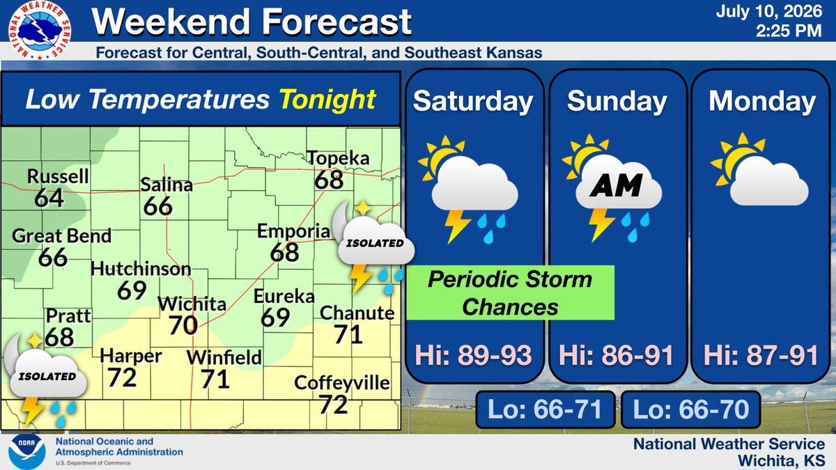
NWS Wichita

49.3K posts

NWS Wichita banner
NWS Wichita

NWS Wichita

@NWSWichita

Official Twitter account for the National Weather Service Wichita. Details: https://t.co/rmH0qnntGq

Wichita, KS Katılım Haziran 2012
257 Takip Edilen46K Takipçiler
NWS Wichita
NWS Wichita@NWSWichita·
An active and warm weather pattern is expected through the end of the week. After near normal temperatures today, temperatures in the 80s and 90s are expected into the weekend. Repeated chances for a few showers and storms are also expected. #KSwx
NWS Wichita tweet media
English
0
0
5
579
NWS Wichita
NWS Wichita@NWSWichita·
Above normal temperatures are expected through at least Friday, with many locations seeing highs in the 90 for both Thursday and Friday. There will be a slight chance for an isolated storm late Thursday afternoon into the early evening hours, mainly across central Kansas #kswx
NWS Wichita tweet media
English
0
0
8
935
NWS Wichita
NWS Wichita@NWSWichita·
A storm or two may develop along a southward moving cold front this evening. The Flint Hills into southeast Kansas will have the best chance to see a storm or two. Hail up to quarter size along with 60 mph winds will be possible with the stronger storms. #kswx
NWS Wichita tweet media
English
0
1
8
843
NWS Wichita
NWS Wichita@NWSWichita·
Above normal temperatures are expected for the next several days with isolated severe chances both this evening and again on Thursday. Thunderstorm chances today will generally be along and east of the Turnpike. #KSwx
NWS Wichita tweet media
English
0
2
10
981
NWS Wichita
NWS Wichita@NWSWichita·
Above normal temperatures are expected for Tuesday through Thursday. Many locations will see highs in the 90s on Tuesday and Thursday. #kswx
NWS Wichita tweet media
English
0
3
12
1K
NWS Wichita
NWS Wichita@NWSWichita·
A few storms are expected develop along a southward moving cold front early Tuesday evening. The Flint Hills into southeast KS will have the best chance to see a storm or two. Hail up to golf ball size along with 60 mph winds will be possible with the stronger storms #kswx
NWS Wichita tweet media
English
0
5
12
1.2K
NWS Wichita
NWS Wichita@NWSWichita·
A warmup begins today that will lead to temperatures in the 80s and 90s through the rest of the week. Isolated storm chances return tomorrow for southeast Kansas. Otherwise, mostly sunny and dry conditions are expected. #KSwx
NWS Wichita tweet media
English
0
0
19
1.2K
NWS Wichita
NWS Wichita@NWSWichita·
A few severe storms are possible Tuesday afternoon and evening across the yellow shaded area. The strongest storms may produce hail up to golf ball size and wind gusts near 60 mph. #kswx
NWS Wichita tweet media
English
0
6
14
1.4K
NWS Wichita
NWS Wichita@NWSWichita·
Above average temperatures are forecast this week with many areas seeing highs near 90 by Tuesday. Chances for storms will return on Tuesday across southeast Kansas, with additional opportunities for storms arriving by the end of the week. #kswx
NWS Wichita tweet media
English
0
2
12
1.1K
NWS Wichita
NWS Wichita@NWSWichita·
Following the departure of light rain showers in southern Kansas, high temperatures in the 60s and low 70s are forecast across the state today alongside partly to mostly cloudy skies. #kswx
NWS Wichita tweet media
English
0
2
10
997
NWS Wichita
NWS Wichita@NWSWichita·
Scattered showers and storms will continue to develop and track eastward across central Kansas through the evening hours. Some of the stronger storms will be capable of producing up to quarter size hail and winds up to 65 mph. #kswx
NWS Wichita tweet media
English
0
3
16
1.5K
NWS Wichita
NWS Wichita@NWSWichita·
Aside from a few showers Sunday morning and Tuesday evening, the upcoming week looks to remain dry with warm temperatures. #kswx
NWS Wichita tweet media
English
0
0
11
1.2K
NWS Wichita
NWS Wichita@NWSWichita·
A few severe storms are possible tonight, primarily along and west of a line from Great Bend to Anthony. The most likely timeframe is from 1 AM through 5 AM. The strongest storms may produce hail up to quarter size and 60 mph wind gusts. #kswx
NWS Wichita tweet media
English
0
2
14
1.4K
NWS Wichita
NWS Wichita@NWSWichita·
Rain and storm chances will increase again this afternoon and will last into the overnight hours. A few showers will linger into Sunday morning, then clearing conditions and warmer temperatures are expected for Monday. #KSwx
NWS Wichita tweet media
English
0
1
13
1.5K
NWS Wichita
NWS Wichita@NWSWichita·
Severe Weather Outlook Through 8 PM: Thunderstorms continue to move across southeast Kansas this evening. The strongest activity will be capable of quarter size hail, wind gusts up to 60 mph, and locally heavy rainfall. #kswx
NWS Wichita tweet media
English
0
1
7
1.2K
NWS Wichita
NWS Wichita@NWSWichita·
Severe Weather Outlook Through 6 PM: A few severe storms are possible across the yellow shaded area. The strongest storms may produce hail up to half dollar size, damaging winds near 60 mph, and heavy rainfall. #kswx
NWS Wichita tweet media
English
0
2
9
959
NWS Wichita
NWS Wichita@NWSWichita·
Vigilancia de Tormenta Severa ha sido emitida para partes de Kansas, Oklahoma y Texas hasta las 10 PM CDT
NWS Wichita tweet media
Español
0
0
3
924
NWS Wichita
NWS Wichita@NWSWichita·
A severe thunderstorm watch has been issued for parts of Kansas, Oklahoma and Texas until 10 PM CDT
NWS Wichita tweet media
English
1
1
6
804
NWS Wichita
NWS Wichita@NWSWichita·
Southeast Kansas will have a chance for a few showers and thunderstorms this afternoon and evening, with another rounds of storms expected on Saturday evening and Saturday night. Clearing skies and cooler conditions are expected Sunday with a warming trend on Monday. #kswx
NWS Wichita tweet media
English
0
2
15
948
NWS Wichita
NWS Wichita@NWSWichita·
Scattered storms will be possible along a southeastward moving cold front this afternoon and early evening. A couple of severe storms will be possible before the activity diminishes and moves away from the area early this evening. #kswx
NWS Wichita tweet media
English
0
2
10
924