⚠️⚠️ Jasper Complex Wildfire ⚠️⚠️
Current as of: July 24, 7:10 pm, Mountain Time
---
Around 6:40 pm this evening, wildfire reached the Jasper townsite.
⚠️⚠️ Jasper Complex Wildfire ⚠️⚠️
Current as of: July 24, 1800h, Mountain Time
At just before 6 pm this evening, portions of the South Fire in Jasper National park reached the outskirts of the Jasper townsite after being driven by strong winds gusts from the south and southeast.
I’m back in the lab this week @CBCVancouver . Stories were following: keeping track of the changing #wildfire situation in the BC Interior, plus your @celeboflight forecast for tonight’s fireworks at English Bay.
5/ Something to keep an eye on: Inland routes east of Metro #Vancouver & through the #FraserValley may experience a prolonged spell of #freezing rain lasting throughout Thursday night and into Friday morning, but this does NOT apply to coastal areas. #bcstorm
4/ As precipitation redevelops late Thursday, it may be a mix of #snow, rain & #freezing rain for several hours Thursday evening, before the #arctic air is finally flushed away during the night. All precipitation changes over to rain as temps rise to +2 ahead of sunrise Friday.
3/ It may turn out to be about a 24-hour period (3pm Wed to 3pm Thu) of dry and cold conditions across Metro #Vancouver, before precipitation redevelops late Thursday afternoon. We are not quite out of the woods yet. #bcstorm
2/ Drier and colder conditions re-emerge through day's end with skies partially clearing tonight and temperatures dipping back down to -3, with windchills near -6, as the shallow layer of leftover #arctic air is resupplied by a developing northeast outflow breeze. #bcstorm
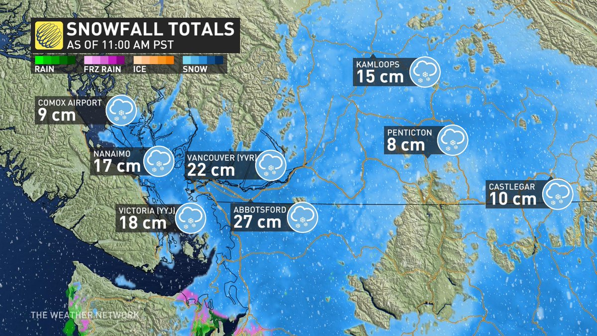
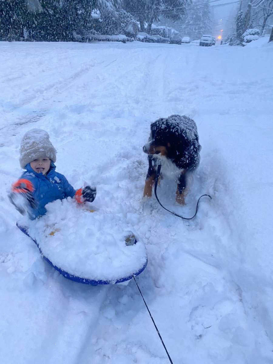
1/ #Bcstorm weather update midday Wednesday: Reported accumulations of 15 to 25 cm across
Metro #Vancouver so far, with another 5 cm to come, as snowfall becomes lighter and intermittent early this afternoon, then ends near 3pm.
@ChrisWe56184750@vlad_rad It'll be a light snow, but continuous for 15 to 18 hours, hence the higher totals around the region. With a temperature near zero all day it's more likely to stick and pile up as opposed to blowing and drifting.
5/ Finally the last of these scraps of trapped #arctic air will be flushed away Thursday night, as all precipitation across Metro #Vancouver changes phases to #rain later Thursday night and into Friday morning. Back to 'normal' weather (milder & wet) this weekend. #bcstorm
4/ The surface pressure gradient and associated #outflow#wind is a little stronger with the next in this coming series of weather systems, due late in the day on Thursday. So some areas will again see #snow mixed with #freezing rain for a few hours Thursday eve. #bcstorm
3/ #Snow continues to accumulate Wednesday, with another 10 cm in the morning, then 2 to 5 cm in the afternoon. This is almost exclusively a snow event, as temperatures remain near zero all day across Metro #Vancouver. Snow ends and the pattern dries out by sunset Wednesday.
2/ Only a little patchy #freezing rain mixes in late overnight and through daybreak Wednesday, as much of the warmer air aloft gets pinched off to the south and into Washington State by the Pacific jetstream.
1/ Forecast fine-tuning: Remaining dry under an increasingly cloudy sky today and this evening, followed by the first few #snowflakes arriving close to 10:00 pm. Overnight accumulations 8 - 12 cm between midnight and sunrise Wednesday. #BCStorm
@weatherwhiz I don't disagree. The precipitable water is there (estimating 15 to 35 mm available water), but the X-factor will be the influence of the jet stream pushing in that warmer air aloft. Curious to note that the 'warmest' outputs this morning are from the 'higher-res' models. HRRR
@RLacate Models keeping outflow and low further south. Not much warm nose present, so at this time looking like snow everywhere overnight Tues into Wed. Lots of warnings will likely be issued for snow next 12-24 hrs
1/ Winter Weather Update from 12z model run: Filtered sunshine with sub-zero temps today. Clouding over Tuesday as temp finally climbs above zero. Potential winter storm by midweek, as #snow begins Tuesday night leading into a slick Wednesday mix of snow, sleet and freezing rain.
4/ Due to the frozen ground, and the low-level outflow breeze ahead of the midweek #BCstorm it seems likely that snow on Tuesday night will succeed in sticking and accumulating even right down to sea level initially, setting the stage for a troublesome Wednesday morning commute.