Sabitlenmiş Tweet
Ryan Shoptaugh
15.6K posts


Ryan Shoptaugh
@RShoptaugh
Somewhere talking up a storm ⛈ l 31 l TX l Meteorologist ☈ • Weather Producer @KENS5 • #UIW • @TEGNA • Questions? 📲 [email protected]
San Antonio, TX Katılım Aralık 2011
1.2K Takip Edilen2.3K Takipçiler
HOLIDAY WEEKEND RAIN? 🌧️ The days leading up to Mother's Day will be a little active! A coastal low will help produce scattered rain Thursday, Friday and Saturday. This rain should move out by Saturday night leading to a nice Mother's Day for Texas! #txwx

English
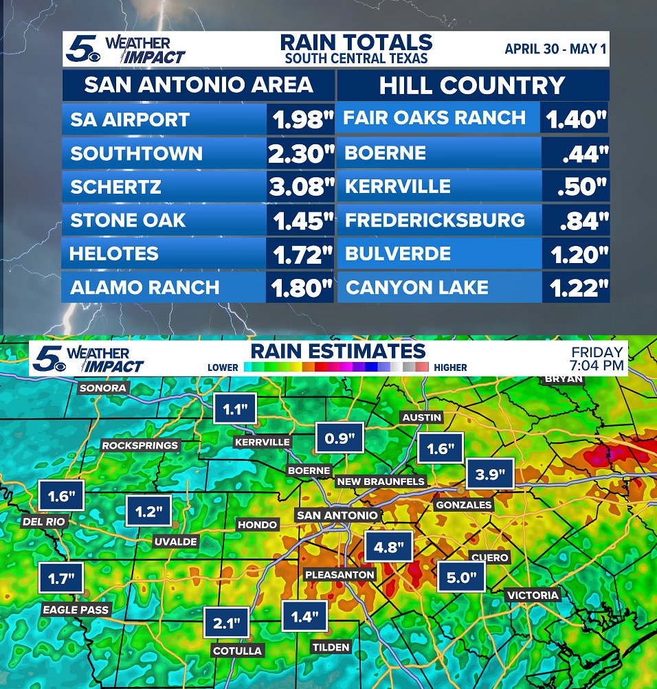
BENEFICIAL RAINS ⛈️ Here's some of the totals and estimates from the last 24 hours across South Central Texas. Highest rain totals were across portions of Atascosa, Wilson, and Karnes counties. #txwx
English
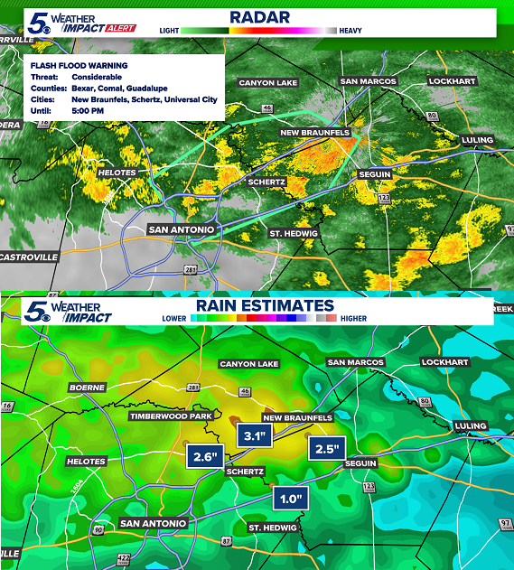
8:30 AM - Around 2" - 5" on average has fallen across the area, mainly around the San Antonio metro and between I-35 and I-10. A flash flood warning continues for portions of Bexar, Comal and Guadalupe counties. Expect high water along creeks, highways, streets, etc. #txwx

English
Minor to moderate flooding may occur into Friday afternoon! With showers and thunderstorms moving across Central and South Texas, high water accumulating will be the primary concern. May starting off WET! ☔ #txwx

English
While some storms will form south, the focal point for heavy rain Friday into Saturday morning will be across Central and East Texas. This will create a localized flooding threat Friday. Stay aware as some areas may experience high water Friday night. #txwx

English
LATE WEEK RAIN? 🌧️Depending on how slow this next cold front moves this week will determine where exactly showers and storms push through Texas. Pockets of heavy rain may range from Central to South Texas by Friday afternoon. #txwx

English
Skies have been HAZY lately. Yes, some of it is clouds but it's also a byproduct of agricultural burning in Mexico during Spring. South winds will help carry smoke northward closer to Texas reducing air quality. Thankfully, a cold front his week will push it out! #txwx

English
RAIN TOTALS 🌧️Northeast San Antonio was the big winner with some areas observing over half a foot of rainfall in less than a day. INCREDIBLE! More rain expected over the next few days with overall less and less coverage with spotty activity into the weekend. #txwx

English
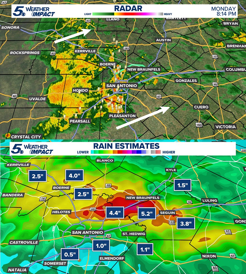
8:15 PM - MORE rain and storms continue to move through overnight. This will likely lead to more high water into Tuesday morning. Streams, creeks, highways, roads, etc. Account for extra time tomorrow as another round of rain pushes across South Texas. #txwx
English
English

2 PM - A flash flood warning continues for northeast San Antonio up I-35 until this evening. Around 1" - 3" of rain so far, expect flooded areas in creeks, streams, roads, highways, etc. #txwx
English

8:20 AM - Showers and storms continue to form and push east this morning. We'll be in this rainy pattern at least through Tuesday night before rain chances trend down. Some high water and minor flooding may occur in your area as more rain pushes through overnight. #txwx

English
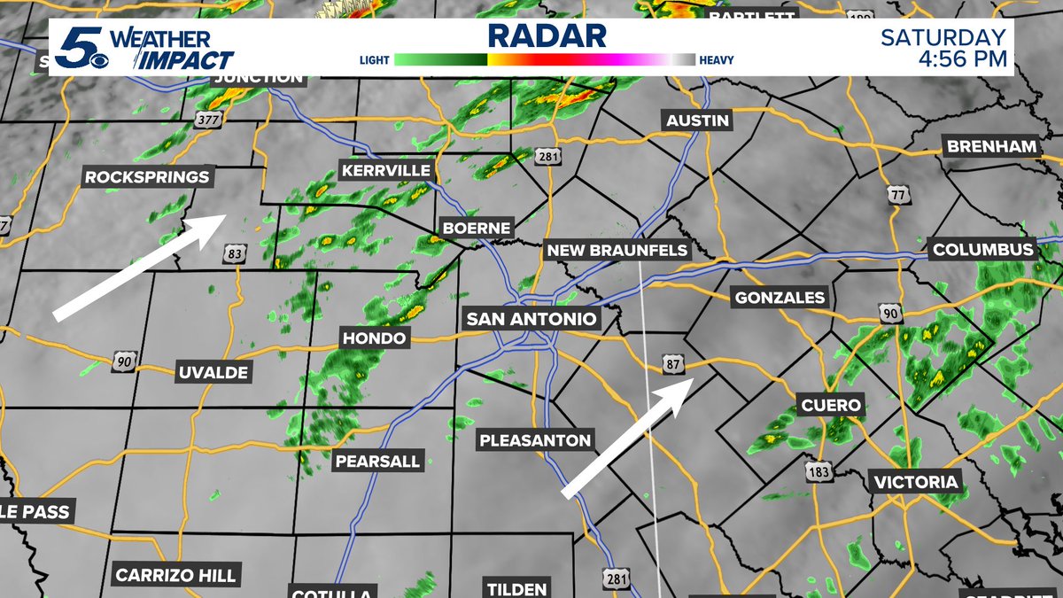
4:57 PM - Radar filling in with more showers and storms this evening. Expect higher rain coverage as we move into the night and overnight hours across Central and South Texas. #txwx
English
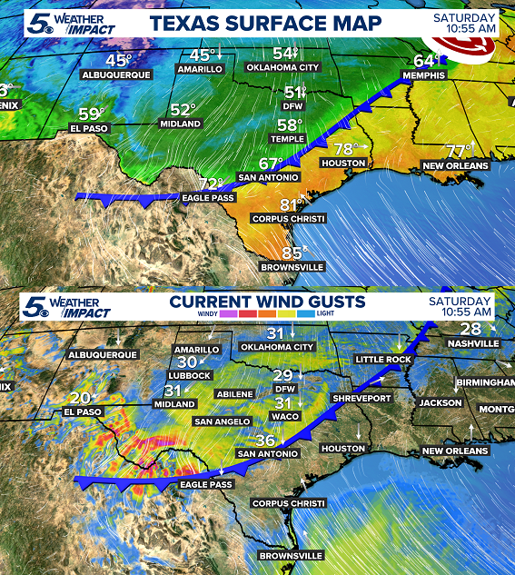
10:55 AM - Cold front is here! Expect cooler air, strong north winds, scattered showers on and off for the rest of today. Be safe everyone! #txwx
English
STRONG WINDS THIS WEEKEND 🌧️ After 1 PM Saturday, wind speeds will increase with gusts near 40 MPH at times. Bring any outdoor items indoors tonight! This will also push temperatures down into the 50s, Sunday morning. #txwx

English
APRIL COLD FRONT 🌧️ After daytime highs in the 80s and 90s Friday, big changes arrive Saturday afternoon! A cold front will push through increasing northerly winds and bringing scattered showers. Some rain will linger Sunday with some heavy rain south of San Antonio. #txwx

English
Cold front this weekend is trending earlier on Saturday. Likely moving through South Central Texas during the afternoon. With its passage, scattered areas of rain with some downpours around into Saturday night. Heavy rain stays south Sunday with much cooler air around! #txwx

English
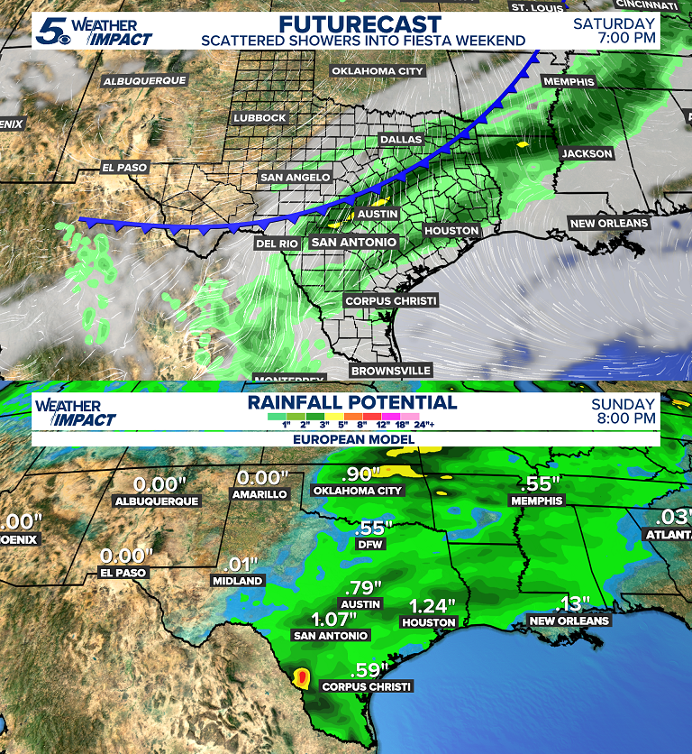
WEEKEND SHOWERS ☁️ Timing looks likely for Saturday evening into the overnight hours of Sunday morning. Scattered showers with some pockets of downpours and storms. Some leftover rain into Sunday. #txwx
English
WEEKEND SHOWERS ☁️ Timing looks for likely for Saturday evening into the overnight hours of Sunday morning. Scattered showers with some pockets of downpours and storms. Some leftover rain into Sunday. #txwx

English