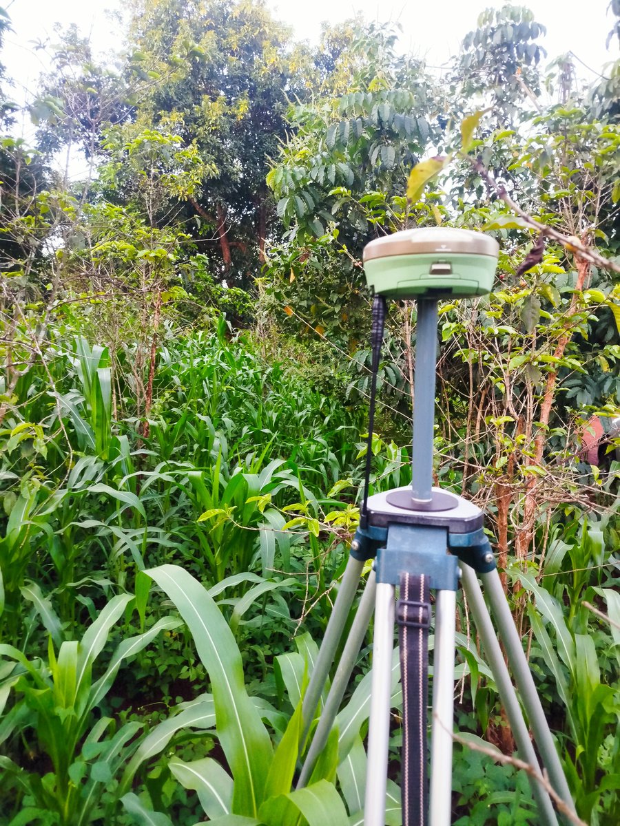
𝖶𝗁𝗒 𝖽𝗈 𝗌𝗂𝗍𝖾 𝖽𝖾𝗏𝗂𝖺𝗍𝗂𝗈𝗇𝗌 𝗈𝖼𝖼𝗎𝗋 𝖾𝗏𝖾𝗇 𝖺𝖿𝗍𝖾𝗋 𝗉𝗋𝗈𝗉𝖾𝗋 𝗌𝖾𝗍𝗍𝗂𝗇𝗀 𝗈𝗎𝗍 𝗁𝖺𝗌 𝖻𝖾𝖾𝗇 𝖼𝗈𝗆𝗉𝗅𝖾𝗍𝖾𝖽?
Setting out is expected to establish accuracy from the start.
So when deviations appear afterward, it raises a critical question:
What changed?
Because in many cases, the issue is not that setting out was wrong; but that conditions, handling, or interpretation changed after it was done.
This is an important reality in field operations:
Accuracy at one stage does not guarantee accuracy at all stages.
So where do these deviations come from?
– Disturbance of control points
Benchmarks, pegs, or reference marks may be moved, damaged, or removed during ongoing site activities.
– Construction execution errors
Even when points are correctly set, incorrect interpretation or poor workmanship can shift actual placement.
– Lack of continuous verification
Once setting out is completed, failure to re-check positions during construction allows small shifts to go unnoticed.
– Environmental and ground factors
Soil movement, vibration, or settlement can alter previously established positions.
– Communication gaps
Instructions may be misunderstood or not properly transferred between surveyors, engineers, and site workers.
– Use of inconsistent reference points
Teams may unknowingly work from different control or outdated data.
– Tolerance mismanagement
Allowing small acceptable deviations at multiple stages can accumulate into significant misalignment.
This leads to a key professional insight:
Setting out is not a one-time activity; it is a controlled process that must be maintained throughout construction.
Initial accuracy must be protected through:
– Continuous checks
– Clear communication
– Control point preservation
– Coordinated execution across teams
Because once construction begins, the environment becomes active; and without control, even correct positions can shift.
The most reliable projects are not those where setting out was done once, but those where accuracy is continuously verified from start to finish.
So here is a question for real field experience:
Have you encountered a situation where everything was set out correctly, but still ended up deviating?
What do you believe caused it?
Let's learn from real project challenges
#SurveyingLife#SiteReality#ConstructionAccuracy#FieldChallenges#SurveyorMindset
𝖶𝗁𝖺𝗍 𝖼𝖺𝗇 𝖻𝖾 𝖽𝗈𝗇𝖾 𝗍𝗈 𝗋𝖾𝖽𝗎𝖼𝖾 𝗁𝗎𝗆𝖺𝗇 𝖾𝗋𝗋𝗈𝗋 𝗂𝗇 𝗌𝗎𝗋𝗏𝖾𝗒𝗂𝗇𝗀 𝗈𝗉𝖾𝗋𝖺𝗍𝗂𝗈𝗇𝗌?
Human error remains one of the most underestimated risks in surveying.
Not because professionals lack competence; but because the field environment is dynamic, demanding, and often unforgiving.
Long hours. Repetitive tasks. Tight deadlines.
And in the middle of it all, decisions are still made by people.
So the goal is not to eliminate human error entirely; that's unrealistic.
The goal is to build systems that make errors difficult to occur, and easy to detect.
Because most mistakes in surveying are not dramatic failures.
They are subtle:
A skipped check.
A misread value.
A misplaced point.
A moment of distraction.
And once they pass unnoticed, they don't remain isolated; they spread through the workflow.
So how do we reduce them effectively?
It begins with discipline and structure:
– Standardized workflows that guide every task from setup to data recording
– Checklists that remove reliance on memory, especially under pressure
– Deliberate verification of critical points, even when results appear correct
– Clear communication to prevent misinterpretation between team members
– Proper data management to avoid errors during recording and transfer
– Continuous training to strengthen both technical skill and decision-making
– Fatigue awareness; because tired minds make avoidable mistakes
– Understanding instruments, not just operating them
Because the truth is simple:
Most errors don't come from what we don't know, they come from what we assume.
The most reliable surveyors don't work on autopilot.
They stay intentional.
They question results.
They confirm before they proceed.
And over time, that mindset builds consistency; the kind that projects depend on.
So here's a question worth reflecting on:
In your own field experience, what has been the most common source of human error?
And what system or habit has helped you reduce it the most?
Let's learn from real experiences
#SurveyingLife#HumanError#FieldDiscipline#EngineeringAccuracy#SurveyorMindset
𝖧𝗈𝗐 𝗌𝗁𝗈𝗎𝗅𝖽 𝖺 𝗌𝗎𝗋𝗏𝖾𝗒𝗈𝗋 𝗁𝖺𝗇𝖽𝗅𝖾 𝗋𝖾𝖿𝗎𝗌𝖺𝗅 𝗈𝖿 𝖼𝗈𝗋𝗋𝖾𝖼𝗍 𝖿𝗂𝖾𝗅𝖽 𝗂𝗇𝗌𝗍𝗋𝗎𝖼𝗍𝗂𝗈𝗇𝗌?
It's a situation that can quickly test both professionalism and patience on site.
The data has been verified. Control points are confirmed. Instructions are issued based on accurate measurements; yet they are resisted or outright rejected. Work may continue based on assumptions, and the risk begins to grow.
So what is the right way to handle it?
It begins with staying composed and objective.
Refusal on site can come from pressure, misunderstanding, or conflicting expectations. Responding with frustration only escalates the situation. A calm, professional approach keeps the focus where it should be; on the facts.
Clarity is the next step.
Rather than repeating instructions, the reasoning behind them must be explained. When field teams understand how positions, levels, or alignments affect the overall project, resistance often reduces. People are more likely to follow what they clearly understand.
Evidence strengthens position.
Verified data, control references, and documented checks should be presented to support the instruction. When decisions are backed by clear proof, they move from opinion to fact.
There is also value in engaging collaboratively.
Instead of turning the situation into a disagreement, it helps to involve engineers or supervisors in a joint review. When all parties examine the same data together, the focus shifts from who is right to what is correct.
Documentation becomes critical in such moments.
If correct instructions are ignored, it must be recorded. This protects the integrity of the work and ensures accountability if issues arise later.
And when necessary, escalation is not a weakness; it is responsibility.
If refusal continues and poses a risk to quality or safety, it should be taken to higher authority for resolution. Accuracy should never be compromised to maintain temporary progress.
Because in reality, ignoring correct field instructions does not eliminate a problem; it only delays its impact.
And delayed problems are often more costly and more difficult to correct.
So the real question is:
When accuracy is resisted on site, do we step back—or stand firm with clarity and evidence?
Let’s discuss... How should professionals handle situations where correct instructions are not followed?
#SurveyingPractice#ConstructionChallenges#SiteManagement#EngineeringIntegrity#ProfessionalStandards
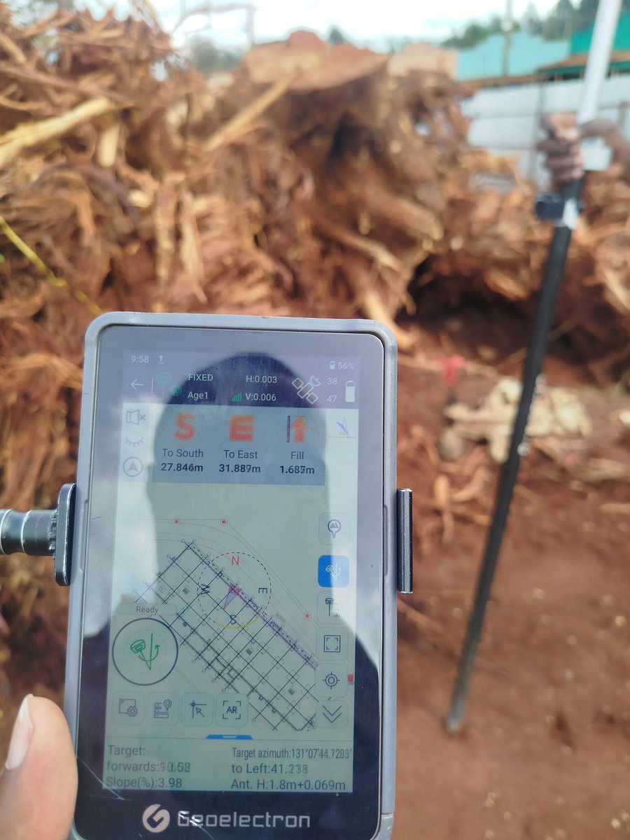
𝖶𝗁𝖺𝗍 𝗁𝖺𝗉𝗉𝖾𝗇𝗌 𝗐𝗁𝖾𝗇 𝗌𝗎𝗋𝗏𝖾𝗒 𝗂𝗇𝗉𝗎𝗍 𝗂𝗌 𝖽𝖾𝗅𝖺𝗒𝖾𝖽, 𝖺𝗇𝖽 𝗁𝗈𝗐 𝖽𝗈𝖾𝗌 𝗂𝗍 𝖺𝖿𝖿𝖾𝖼𝗍 𝗌𝗂𝗍𝖾 𝗉𝗋𝗈𝗀𝗋𝖾𝗌𝗌?
At first, it may seem like a small issue.
Work continues, teams stay active, and decisions are made to “keep things moving.” But beneath that momentum, something critical is missing; verified positioning and control.
And that's where the real problems begin.
When survey input is delayed, construction often shifts from precision to assumption.
Without confirmed coordinates, levels, and alignments, teams may rely on estimates or previous references. What looks like progress on the surface can quickly turn into misalignment, incorrect placement, or uneven levels; issues that are not always visible immediately, but become costly over time.
Delays in survey work also disrupt coordination.
Different teams depend on accurate set-out points to carry out their tasks. When those points are unavailable or late, workflows become fragmented. Some teams pause, others proceed with uncertainty, and the entire sequence of operations begins to lose rhythm.
Then comes the impact on time and cost.
What could have been done right the first time may need to be adjusted, corrected, or even redone. Rework not only slows progress but also consumes resources that were never planned for.
There is also a hidden effect; loss of confidence.
When survey input is inconsistent or delayed, trust in the data begins to weaken. Teams may start bypassing proper checks just to maintain pace, which increases the risk of compounded errors across the project.
But beyond all this, the biggest consequence is risk.
Construction without timely survey input is construction without full control. And without control, quality, safety, and long-term performance are all at stake.
Because in reality, progress is not just about speed; it's about accuracy.
Fast work built on the wrong position is not progress. It’s a problem waiting to surface.
So the real question is:
Is your site moving forward with verified data, or just moving fast without it?
Let's discuss... Have you experienced delays caused by late survey input, and how did it affect your project?
#SurveyingPractice#ConstructionDelays#SiteCoordination#ProjectExecution#EngineeringAccuracy
@surveyor5916 Unfortunately these colours had changed for the final... Again this was not purple colour... Correction was done on this prior to submission mkuu
Good evening Felix, the topo looks good, unfortunately your choice of colors, in cartography, I don't think purple hue is used to define Thematic maps ( data ranging). Next time always have a good color choice
The future of surveying is no longer just about measuring land — it’s about defining reality.
From GNSS and geodetic control to real-time mapping and digital twins, our profession sits at the center of infrastructure, planning, and national development. Yet, despite this critical role, surveyors are often boxed into outdated frameworks that limit innovation, growth, and fair recognition.
A modern surveyor is not just a technician — they are a data scientist, an engineer, a problem-solver, and a key player in decision-making systems. The world is moving fast: smart cities, autonomous navigation, AI-driven mapping. The question is — are our systems evolving just as fast?
We need:
• Progressive policies that reflect current technologies
• Fair professional structures that empower, not restrict
• Recognition of emerging specializations in geospatial science
• Space for young professionals to innovate and lead
If we continue treating surveying like it’s still in the chain-and-tape era, we risk holding back not just professionals — but entire sectors that depend on accurate spatial data.
It’s time to rethink, reform, and reposition surveying for what it truly is: a backbone of modern development.
#Surveying#Geospatial#GNSS#Engineering#Innovation#SmartCities
Are these old buddies in the Surveying Profession in Kenya Enabling Growth or Managing Control and GATE keeping?
The role of any professional regulatory body is clear: to safeguard standards, protect public interest, and ensure the integrity of practice. In surveying, this responsibility is especially critical given the legal, technical, and economic weight attached to land and geospatial data.
However, there is an equally important responsibility that is often less emphasized—the duty to develop, nurture, and enable the next generation of professionals.
Across the profession today, a growing concern is emerging among young and upcoming surveyors:
Is the current regulatory environment enabling growth—or unintentionally limiting it?
While the structures in place aim to maintain order and accountability, there is a noticeable gap when it comes to clear, practical pathways for progression. Many young professionals enter the field with strong technical skills, academic grounding, and exposure to modern technologies, yet find themselves navigating a system where advancement toward independent practice is slow, unclear, and highly constrained.
This creates a difficult reality.
A profession that does not actively create room for its emerging members risks becoming top-heavy—where opportunity is concentrated among a few, while the majority remain in prolonged transition stages. Over time, this not only affects individual careers but also impacts the profession’s ability to innovate, adapt, and remain competitive in a rapidly evolving geospatial landscape.
The concern is not about removing regulation. Far from it.
Strong regulation is necessary. It builds trust, ensures quality, and protects the public. But effective regulation must be balanced with intentional capacity building. Without that balance, even well-intentioned policies can produce unintended consequences—discouraging talent, slowing growth, and creating barriers where there should be bridges.
A forward-looking profession should be asking:
Are there clear and achievable pathways from training to full professional independence?
Are young professionals being mentored—or merely managed?
Are policies encouraging innovation—or maintaining traditional control structures?
Is the system building future leaders—or prolonging dependency?
These are not questions of defiance—they are questions of sustainability.
Globally, professions that thrive are those that evolve. They recognize that empowering young professionals is not a risk—it is an investment. They create systems where mentorship leads to independence, where structure supports innovation, and where regulation works hand in hand with growth.
Surveying in Kenya has immense potential. With advancements in GNSS, remote sensing, GIS, and digital mapping, the scope of the profession is expanding rapidly. Harnessing this potential requires more than control—it requires inclusion, adaptability, and vision.
The conversation, therefore, should not be about resisting authority, but about strengthening the profession as a whole.
Because in the end, the strength of any profession is not measured only by how well it regulates—but by how effectively it prepares its next generation to take over, lead, and push it forward.
The future of surveying depends on whether we choose to create space—or maintain limits.
#Surveying#Geospatial#ProfessionalGrowth#Leadership#YoungProfessionals#Kenya#Reform
𝖶𝗁𝗈 𝗋𝖾𝖺𝗅𝗅𝗒 𝖼𝗈𝗇𝗍𝗋𝗈𝗅𝗌 𝖺 𝖼𝗈𝗇𝗌𝗍𝗋𝗎𝖼𝗍𝗂𝗈𝗇 𝗌𝗂𝗍𝖾, 𝖺𝗇𝖽 𝗁𝗈𝗐 𝗌𝗁𝗈𝗎𝗅𝖽 𝖽𝖾𝖼𝗂𝗌𝗂𝗈𝗇𝗌 𝖻𝖾 𝖻𝖺𝗅𝖺𝗇𝖼𝖾𝖽 𝖻𝖾𝗍𝗐𝖾𝖾𝗇 𝖤𝗇𝗀𝗂𝗇𝖾𝖾𝗋𝗌 𝖺𝗇𝖽 𝖲𝗎𝗋𝗏𝖾𝗒𝗈𝗋𝗌?
It's a question that often sparks debate. Engineers will say design governs execution, while surveyors will argue that without accurate positioning, even the best design is meaningless. But the truth is more nuanced.
A construction site is not controlled by a single profession. It is governed by coordination, accuracy, and accountability.
Engineers bring designs to life. They interpret drawings, manage structural integrity, and ensure that every element performs as intended. Their decisions drive what is built and how it should function.
Surveyors, on the other hand, define reality on the ground. They establish control points, verify positions, and ensure that every structure aligns with its intended coordinates. Their role determines where and how accurately it is built.
So who is in control?
Control lies in the integration of both roles.
A decision made by an engineer must always be verified against survey control data to ensure it fits within real-world conditions. Likewise, survey data must be clearly communicated and properly understood to guide engineering execution.
When imbalance occurs; when design overrides field accuracy, or when measurements are ignored; the result is costly errors, delays, and sometimes structural failure.
The most successful construction sites are not led by ego, but by collaboration:
- Engineers respect the authority of accurate survey data
- Surveyors understand the intent behind engineering designs
- Both parties communicate continuously and validate each other's work
Because in reality, no structure stands on drawings alone; and no measurement has value without purpose.
Let's hear your thoughts.. on your site, who truly drives decisions?
#ConstructionManagement#Surveying#EngineeringExcellence#ProjectExecution#BuiltEnvironment
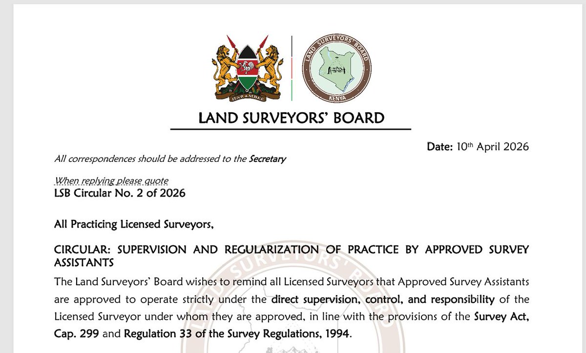
LSB Circular No. 2 of 2026 by the Land Surveyor's Board. Strict Supervision of Approved Assistants by their Licensed Surveyors. What you need to know.
1. Assistants are NOT independent practitioners. They are extensions of the Licensed Surveyor.
2. The Board is emphasizing day-to-day professional control. Including field procedures and methodology. Kama Liscenced wako ni mzee wa miaka 70 beba yeye na kiti yake mpaka Ewaso Kedong ama Loldaiga mkifanya picking. Active involvement, not just signing plans and lending a license name.
3. All work must be under the Surveyor’s firm. Even if an assistant:
-Has an office
-Has clients
That work must be done and produced in the name of the Licensed Surveyor’s registered firm. It must actually fall under that firm’s structure and accountability.
4. The Licensed Surveyor bears FULL professional and legal responsibility.
In my view buana this is industry restructuring by Licensed Surveyors, to kill and decimate parallel practices by younger professionals. This is totalitarianism. The strict enforcement is more restrictive than protective. The circular is 30% quality control and 70% gatekeeping.
Mnaonaje hapa wenzangu @SurveyorOfKenya, @Artisurvey@Surveyor_001.