Ryan Hall, Y’all

13.7K posts

Ryan Hall, Y’all banner
Ryan Hall, Y’all

Ryan Hall, Y’all

@ryanhallyall

Digital Meteorologist | Creative Technologist | The Internet's Weather Man |

Kentucky, USA Katılım Ocak 2009
1.3K Takip Edilen479.6K Takipçiler
Ryan Hall, Y’all
Ryan Hall, Y’all@ryanhallyall·
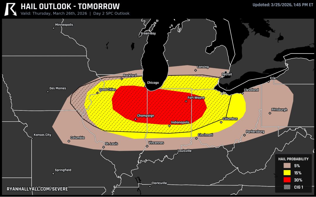
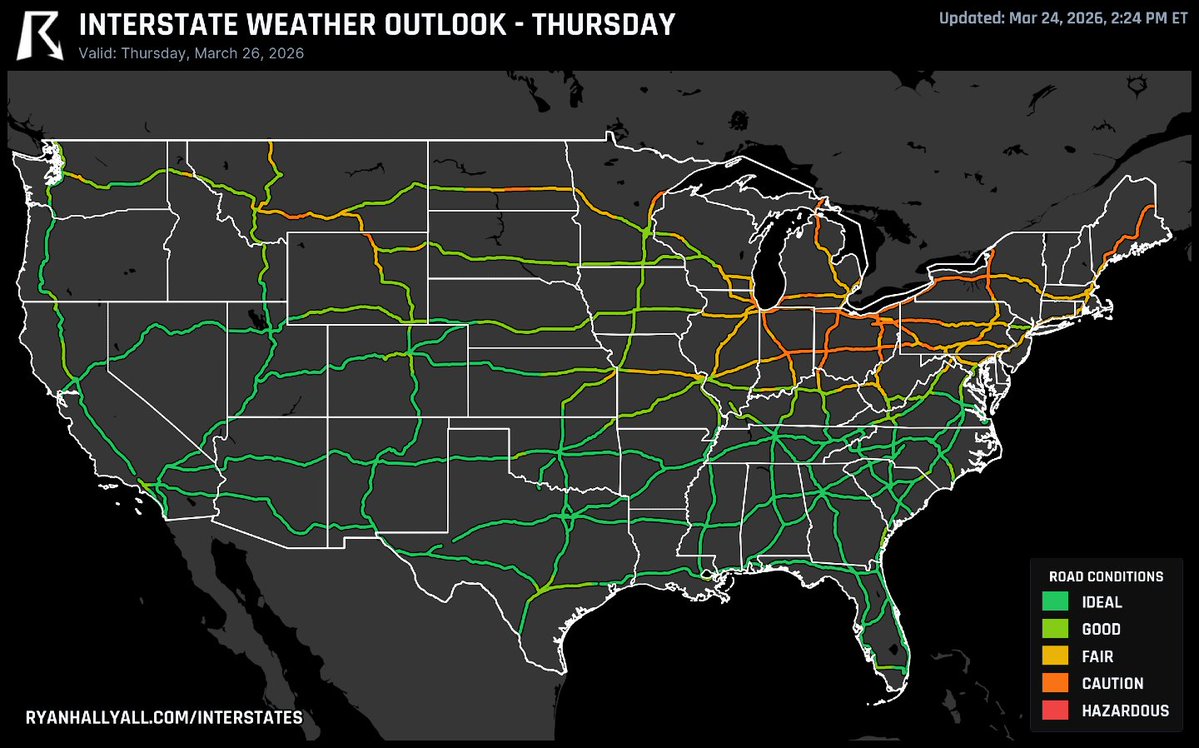
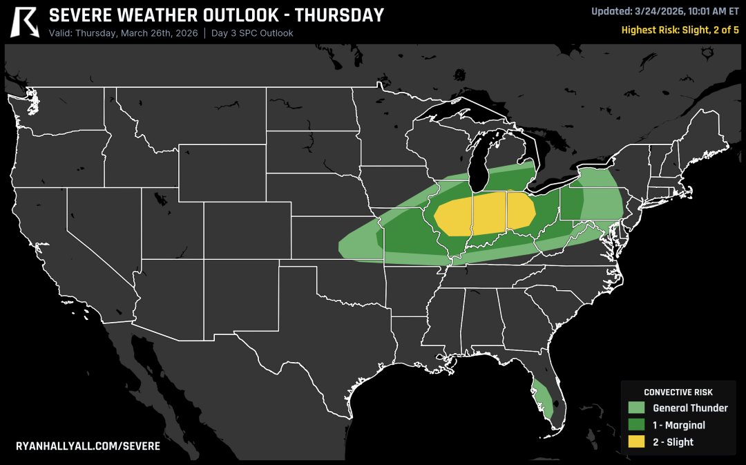
If you're flying tomorrow, it could be a rough one. Severe storms are threatening ground stops at Chicago, Detroit, and Cleveland by the evening, and heavy rain could back up the Northeast corridor overnight. Check your flight before you head to the airport.
Ryan Hall, Y’all tweet media
English
7
51
362
23.8K
Ryan Hall, Y’all
Ryan Hall, Y’all@ryanhallyall·
A wild front is slamming the Midwest this Thursday. Chicago will see temperatures crash from the 80s to the 40s in hours. This massive drop brings a serious threat of severe thunderstorms, damaging winds, and potential tornadoes. Stay weather aware.
English
6
58
429
24.2K
WeatherWise.app
WeatherWise.app@WxWiseApp·
🚀 Minimum Correlation Coefficient Turn on Minimum Correlation Coefficient to build up a clearer picture of debris over time, helping you trace the path of a tornado across multiple scans. Available now for Pro subscribers.
English
4
2
31
2.1K
Ryan Hall, Y’all retweetledi
WeatherWise.app
WeatherWise.app@WxWiseApp·
🚀 Mega Update for Severe Weather Season Today, we’re rolling out improvements across every tier, from Free to Pro. Free: - Faster Radar Updates - Super-Res Storm Relative Velocity - Super-Res Normalized Rotation - Radar Scan Sounds and Device Vibration - Enhanced Storm Tracks - Custom Radar Range Ring Color - Landscape Support - New WeatherWise Home Compass Widget - Android Back Button Support Plus: - MRMS Storm Tracks - Storm Track Trails Pro: - Tower Icon Blinker - Historical Storm Track/Cell Data - Minimum Correlation Coefficient Available now on: iOS: apple.co/4hffiwF Android: bit.ly/3NNDFUw Browser: web.weatherwise.app And to Plus/Pro subscribers using our Windows/Mac/Linux App
English
18
50
254
40.6K
Ryan Hall, Y’all
Ryan Hall, Y’all@ryanhallyall·
SPC just bumped tomorrow to a Level 3 from Illinois into western Ohio. Supercells are expected to fire late afternoon with hail over 2 inches, then transition into a damaging wind event as storms merge into a line by evening. If you're in the warm sector, stay alert.
Ryan Hall, Y’all tweet media
English
17
79
818
63.7K
Ryan Hall, Y’all
Ryan Hall, Y’all@ryanhallyall·
Today will be the best day of the year so far in the Mid-South and lower Ohio Valley. 70s, dry air, wall to wall sunshine. Go outside
Ryan Hall, Y’all tweet media
English
26
56
585
66.4K
Ryan Hall, Y’all
Ryan Hall, Y’all@ryanhallyall·
Tomorrow's setup across the Midwest has the spin to produce tornadoes, including a potentially significant one. The wind profiles are extremely favorable from northern Illinois into northwest Ohio. Very large hail up to 3 inches is also on the table.
Ryan Hall, Y’all tweet media
English
51
155
1.5K
256.5K
Ryan Hall, Y’all
Ryan Hall, Y’all@ryanhallyall·
Thursday’s trouble spots are the Ohio Valley and Northeast. Storms rolling through I-80/I-90 in OH, IN, and IL with heavy rain and gusty winds, then a nasty evening slug of rain hitting western NY. Northern New England gets a winter mix for the morning commute. Southeast is smooth sailing. Full map and breakdown at ryanhallyall.com/interstates
Ryan Hall, Y’all tweet media
English
9
26
346
31K
Ryan Hall, Y’all
Ryan Hall, Y’all@ryanhallyall·
Severe thunderstorms are expected Thursday afternoon and evening across central Illinois, Indiana, and western Ohio. Damaging winds are the main threat, but large hail and tornadoes are possible. The storms could push into PA and WV overnight. Stay weather aware.
English
9
71
517
41.3K
Ryan Hall, Y’all
Ryan Hall, Y’all@ryanhallyall·
Thursday's Level 2 risk targets central Illinois into Indiana and western Ohio. Damaging winds are the main threat, but if storms stay discrete there's potential for large hail and tornadoes. The atmosphere is reloading fast after this quiet stretch.
Ryan Hall, Y’all tweet media
English
7
27
328
18.3K
Ryan Hall, Y’all
Ryan Hall, Y’all@ryanhallyall·
2 new sky cams just went up in Alabama today! These are the first of 100+ cams we’re actively installing across the US. We’re gonna SEE EVERY STORM!
Ryan Hall, Y’all tweet mediaRyan Hall, Y’all tweet media
English
27
56
1K
40.7K
Ryan Hall, Y’all
Ryan Hall, Y’all@ryanhallyall·
Watching Thursday closely. Models are suggesting severe storms could fire from northeast Missouri into Ohio with dewpoints climbing into the 60s and strong wind shear in place. Still 4 days out but the ingredients are there.
Ryan Hall, Y’all tweet media
English
18
57
650
45.3K
Ryan Hall, Y’all
Ryan Hall, Y’all@ryanhallyall·
@impickinuoff Yes, I’d WIS is forecast to >88 before 6pm we will be live. Look for us as early as 2 or 3
Ryan Hall, Y’all tweet media
English
1
2
26
3.7K
Michael
Michael@impickinuoff·
@ryanhallyall Does this increase your chances of going live? If so what time do you think approximately?
English
1
0
1
3.7K
Ryan Hall, Y’all
Ryan Hall, Y’all@ryanhallyall·
Level 2 risk today across the Ohio Valley into the Mid-Atlantic. Supercells with very large hail up to 2.5 inches and damaging winds this afternoon and evening. There's a small chance we go live for this so we're standing by.
Ryan Hall, Y’all tweet media
English
10
52
506
149.9K
Ryan Hall, Y’all
Ryan Hall, Y’all@ryanhallyall·
Ever wish there was a weather map that just showed you where it's gonna be BEAUTIFUL? We made one. The Nice Weather Outlook is a 7 day forecast scoring every part of the US from Fair to Pristine based on temp, humidity, wind, sun and rain. Updated 4x daily. Also available in the Weatherwise app, with full text discussions for Plus subscribers. You're welcome.
Ryan Hall, Y’all tweet media
English
95
146
2.2K
108.9K