SCS Comment

215 posts

SCS Comment banner
SCS Comment

SCS Comment

@SCSHuayang

Official account of Huayang Center for Maritime Cooperation and Ocean Governance. Follows, RTs≠endorsement.

Haikou, China Katılım Nisan 2023
59 Takip Edilen68 Takipçiler
Sabitlenmiş Tweet
SCS Comment
SCS Comment@SCSHuayang·
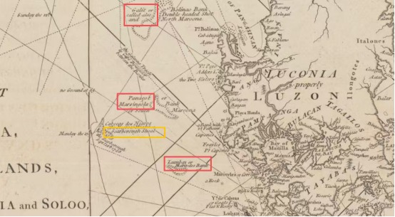
1. The Philippines cites the 1734 Velarde map (p1)("Panacot") to argue that Panacot = Huangyan Dao (Scarborough Shoal). In the map, Panacot is located in middle of the three shoals off the west coast of Luzon. 2. The English name "Scarborough Shoal" comes from the British East Indiaman Scarborough grounding there on 12 Sept 1748—after the Velarde map was published. 
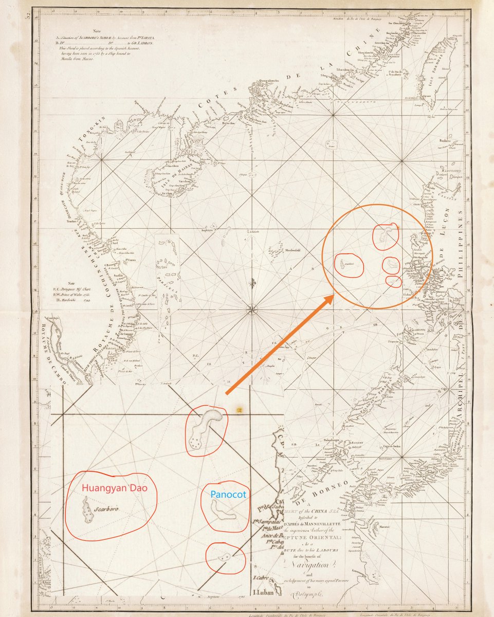
3. In 1775, French hydrographer Jean-Baptiste Nicolas Denis d'Après de Mannevillette published the expanded 2nd ed. of Le Neptune Oriental, including "A Chart of the China Sea"(p2) originally drawn by British cartographer Alexander Dalrymple, the first map to precisely mark the location of the "Scarboro," the island named after the English commercial ship, and the "Scarboro Shoal" is placed to the west of the "three shoals". That means: "Scarboro" should not be wrongly confused with the "middle shoal" of that three-shoal group; it is hence distinct from the "Panacot" featured on the earlier Velarde map. 4. So if someone insists "Panacot is Huangyan Dao,” they must explain why the first explicit "Scarboro" plotting (1775) shows Scarboro separately—west of that three-shoal cluster. 5. Equating Panacot with Huangyan Dao is not a settled historical "fact," but a groundless interpretation that later charts directly refute.
SCS Comment tweet mediaSCS Comment tweet media
English
0
7
14
2.6K
SCS Comment
SCS Comment@SCSHuayang·
Another performative policy from the Philippine government, dressing up an illegal claim in the language of "official naming" and administrative procedure. A reminder: as early as 1935, the Chinese government has published the first standardized set of Chinese and English names for the South China Sea islands. And that is the CORRECT names for those islets, and it's nearly 100 YEARS EARLIER than the Philippines. These features were not "discovered" or suddenly given identity by the Philippines government in 2026. This is a desperate move of the Philippine government to manufacture legitimacy, and quite a pathetic one. It fools no one. Anyone with even a basic knowledge of the South China Sea's documentary history will see through it immediately.
SCS Comment tweet mediaSCS Comment tweet mediaSCS Comment tweet mediaSCS Comment tweet media
Inquirer@inquirerdotnet

President Ferdinand Marcos Jr. has ordered all of the more than 100 features in the Kalayaan Island Group (KIG) in the West Philippine Sea to bear local names in government documents and official maps of the country. Under Executive Order (EO) No. 111 issued on March 26, President Marcos ordered the adoption of the standard set of Philippine names for the 131 features of the KIG, which is part of the Kalayaan municipality in Palawan province. EO 111 directs the National Mapping and Resource Information Authority (Namria) to produce and publish updated charts and maps that reflect the local names. | @dexcabalzaINQ /PDI READ MORE: inqnews.net/LocalNamesKala…

English
0
4
5
133
SCS Comment
SCS Comment@SCSHuayang·
This policy only exposes how ignorant and ahistorical the Philippine government is on the history of the South China Sea. Perhaps the Philippine ought to take a history lesson about the Chinese fishermen's Sailing Route Logs? Here's a free online historical class of the Chinese people's fishing and trading activities in the South China Sea: en.huayangexhibition.com Geng Lu Bu (更路簿, The Sailing Route Logs), is a collection of handwritten booklets compiled by Chinese fishermen over the course of several centuries as they voyaged to the South China Sea islands for fishing, transport, and other activities. These booklets recorded maritime routes in the South China Sea, the names of islands and reefs, ocean currents, and other navigational knowledge. In Shichuan Gengliu Bu (驶船更流簿, p2-4), the sea routes are recorded in individual entries, written vertically in neat small regular script with a brush. Each entry records the compass bearing and the number of “geng” between two locations. p1: a visualized map based on the Geng Lu Bu. p2-4: original text excerpt from Shichuan Gengliu Bu, a type of Geng Lu Bu.
SCS Comment tweet mediaSCS Comment tweet mediaSCS Comment tweet mediaSCS Comment tweet media
Inquirer@inquirerdotnet

President Ferdinand Marcos Jr. has ordered all of the more than 100 features in the Kalayaan Island Group (KIG) in the West Philippine Sea to bear local names in government documents and official maps of the country. Under Executive Order (EO) No. 111 issued on March 26, President Marcos ordered the adoption of the standard set of Philippine names for the 131 features of the KIG, which is part of the Kalayaan municipality in Palawan province. EO 111 directs the National Mapping and Resource Information Authority (Namria) to produce and publish updated charts and maps that reflect the local names. | @dexcabalzaINQ /PDI READ MORE: inqnews.net/LocalNamesKala…

English
0
6
8
1.1K
SCS Comment
SCS Comment@SCSHuayang·
Sorry to interrupt, just dropping the set of standardized Chinese and English name of the South China Sea islands released by the Chinese government in 1935, over 90 years ahead of the Philippine government.
SCS Comment tweet mediaSCS Comment tweet mediaSCS Comment tweet mediaSCS Comment tweet media
English
0
0
2
53
Inquirer
Inquirer@inquirerdotnet·
President Ferdinand Marcos Jr. has ordered all of the more than 100 features in the Kalayaan Island Group (KIG) in the West Philippine Sea to bear local names in government documents and official maps of the country. Under Executive Order (EO) No. 111 issued on March 26, President Marcos ordered the adoption of the standard set of Philippine names for the 131 features of the KIG, which is part of the Kalayaan municipality in Palawan province. EO 111 directs the National Mapping and Resource Information Authority (Namria) to produce and publish updated charts and maps that reflect the local names. | @dexcabalzaINQ /PDI READ MORE: inqnews.net/LocalNamesKala…
Inquirer tweet media
English
2
6
37
3.5K
SCS Comment retweetledi
SCS Comment
SCS Comment@SCSHuayang·
The Philippines is trying to compartmentalize diplomacy while its own maritime frontline forces are unwilling to cooperate, publicly distancing itself from the CCG-PCG agreement. Is the PCG not hijacking the diplomatic policy of the Philippine government? The Philippine Department of Foreign Affairs is negotiating with China over the much-anticipated China-Philippine coast guard cooperation agreement. According to the Chinese Ambassador to the Philippines, the agreement is very close to completion. But on the other hand, the PCG spokesperson Jay Tarriela has publicly denied any PCG involvement in the drafting of the agreement. The real issue here is not whether the agreement can be successfully finalized, but whether the most key element of the agreement - the Philippine Coast Guard - is willing/able to actually carry it out should the agreement eventually come to shape. If the DFA negotiates while the PCG disowns, then the problem is no longer simply the difficulty of China-Philippines cooperation to ease tensions at sea. It is the Philippine government’s apparent inability to ensure internal policy coherence on one of its most sensitive foreign policy issues. philstar.com/headlines/2026…
English
0
2
5
245
SCS Comment retweetledi
ChineseEmbassyManila
ChineseEmbassyManila@Chinaembmanila·
Deputy Spokesperson of the Chinese Embassy Guo Wei: Recently, some forces in the Philippines have been undermining the hard-won diplomatic progress between China and the Philippines. Their approach is fairly straightforward: first, maritime provocations, sending ships and aircraft into China’s waters and airspace and approaching Chinese vessels at close range; second, negative messaging in the media, using selective or distorted claims to stir tensions and shape international perceptions. In just the past two weeks, the Philippine military and coast guard have made multiple intrusions into China’s territorial waters and airspace. March 18: Two C-208 aircraft illegally intruded into China’s territorial airspace over Huangyan Dao (Scarborough Shoal). March 20: One C-208 aircraft illegally intruded into China’s airspace over waters adjacent to Meiji Jiao (Mischief Reef) of China’s Nansha Qundao (Spratly Islands). March 25: Philippine ship 507 ignored repeated warnings, deliberately turned toward PLANS 532 near Zhubi Jiao (Subi Reef), and made a dangerous approach. China responded professionally and avoided an incident—only to be falsely accused afterward. In addition, while the China Coast Guard was conducting routine rights-protection and law enforcement training in waters under its jurisdiction near Huangyan Dao and had issued a navigation safety notice in advance, the Philippine side gathered a large number of vessels to enter the training area. Under the pretext of “fishing”, they attempted to stir up incidents, amplify publicity, and draw international attention. It is also worth recalling statements made by certain Philippine officials: “Diplomacy is important, but it has its limits. Our diplomatic efforts complement our national security, but they cannot substitute for a credible, determined posture.” So the real question is, who exactly doesn’t want to see diplomatic progress and a peaceful, stable South China Sea? With the energy crisis caused by the situation in the Middle East, life in the Philippines is tough for the people. Things are already hard enough, and yet some forces are still trying to stir up trouble with China and destabilize bilateral relations, even hoping to cause more conflict. What’s their game here? What are they really trying to do? Whose interests are they even representing?
ChineseEmbassyManila tweet media
English
1
4
8
327
SCS Comment
SCS Comment@SCSHuayang·
Huayang Perspective | Hainan Free Trade Port🌴 During the last Symposium on Global Maritime Cooperation and Ocean Governance co-hosted by the Huayang Center, we took a series of interview with scholars and experts on topics such as the development of climate change, multilateralism, global ocean governance, and the development of the Hainan Free Trade Port In this episode, we invited experts from Sri Lanka, the Philippines, Belgium, Canada, and Thailand, to talk about their opinion about the future development of the Hainan Free Trade Port, which includes: · Jayanath Clombage, Former Chief of the Navy of Sri Lanka, and Former Ambassador of Sri Lanka to Indonesia · Lucio Pitlo III, President of the Philippine Association for Chinese Studies · Shada Islam (@shada_islam), Founder and Managing Director, New Horizons Project, Belgium · Lu Youyu, Adjunct Professor, Oceanography Department, Dalhousie University, Canada · Sorajak Kasemsuvan, Former Vice Foreign Minister of Thailand; Council Member of Asian Peace and Reconciliation Council Watch the interview below👇
English
0
1
2
50
SCS Comment
SCS Comment@SCSHuayang·
Huayang South China Sea Exhibition The South China Sea Exhibition of the Huayang Center for Maritime Cooperation and Ocean Governance, is a collection of historical evidence, including ancient Chinese books, historical documents, domestic and international maps, diplomatic notes, and historical relics recovered from sunken ships near the ancienty maritime silk road in the South China Sea, that recorded the thousands years of fishing and trading activities of the Chinese people in the South China Sea. The historical documents come from both domestic and international sources, and have been carefully translated into English for international audiences. The Huayang South China Sea Exhibition has been digitalized, and published online: en.huayangexhibition.com Click on this link to visit, read and experience the Chinese account of history in the South China Sea. While tensions in the South China Sea have continued unabated, we hope this series of exhibition shed some light into China's long-time, and rightful sovereignty over the South China Sea islands. We also welcome visitors to our physical exhibition hall based in Haikou, China. To visit, please contact info@huayangocean.com.
English
0
6
8
159
SCS Comment retweetledi
ChineseEmbassyManila
ChineseEmbassyManila@Chinaembmanila·
Deputy Spokesperson of the Chinese Embassy Guo Wei: Mr. Jay Tarriela claims that the 1875 Carta General is one of the most complete and detailed official Spanish maps that clearly depicts philippine territories including Nansha Qundao (Spratly islands) and Huangyan Dao (Scarborough Shoal). He also claims that this map strengthens the historical basis for the Philippine position over these features. HE IS WRONG. First, the 1875 “Carta General del Archipiélago Filipino” is merely a geographical map of the Philippine archipelago. It contains no markings indicating sovereignty and therefore cannot substantiate claims that Huangyan Dao and the Nansha Qundao belong to the Philippines. Second, in the 1928 Island of Palmas Case, the United States presented a 1902 reproduction of this map by the U.S. War Department as evidence in an attempt to claim the island for the Philippines. However, the arbitrator, Max Huber—former President of the Permanent Court of International Justice—explicitly rejected the map on the grounds that it contained “no indication of political boundary.” Third, Panacot ≠ Huangyan Dao (Scarborough Shoal). Panacot refers to Marsingola, located between Galit and Lumbay. In the 1794 map drawn by Robert Laurie and James Whittle, Panacot is clearly identified as Marsingola, while the actual Huangyan Dao lies to the west of Panacot. This suggests that equating the two is based on a misreading of historical sources. Apparently, Mr. Tarriela has uncritically repeated the false narrative that “Panacot = Huangyan Dao” without even examining the original sources. At a time when both sides have agreed to pursue dialogue, distorting history and dismissing established legal reasoning serves no constructive purpose. It changes nothing on the ground. It only calls into question whether those doing so are truly invested in diplomacy, or simply determined to keep tensions alive.
ChineseEmbassyManila tweet mediaChineseEmbassyManila tweet media
English
11
3
11
5.7K
SCS Comment retweetledi
SCS Comment
SCS Comment@SCSHuayang·
Boao Forum for Asia SCS Sub-Forum LIVE | Session III is under way! Moderated by Zhou Yong, Vice President of NISCSS, this session will discuss the Rules and Order in the South China Sea. Expert views and takeaways 👇
SCS Comment tweet media
English
10
4
9
281
SCS Comment
SCS Comment@SCSHuayang·
Xu advises to amplify the synergy between geographical and policy advantages, to scale up trade and to build a substantial trade throughput, and finally to improve port infrastructure.
English
0
1
2
66
SCS Comment
SCS Comment@SCSHuayang·
Boao Forum for Asia SCS Sub-Forum LIVE | Session IV is under way! Moderated by Peter T. C. Chang, Research Associate at Malaysia-China Friendship Association and Former Deputy Director at the Institute of China States of the University of Malaya, this session will discuss the high-quality development of the marine economy in the SCS region and the construction of Hainan Free Trade Port. Expert views and takeaways 👇
SCS Comment tweet media
English
9
6
9
248
SCS Comment
SCS Comment@SCSHuayang·
Wu Shicun, Chairman of the Huayang Center, quotes: ‘despite we have different governments, live in different countries, we all want to live in the way as our father did, raise our family in a peaceful world.” He emphasizes that peace and stability in the region is the common will and the duty of all.
English
0
1
2
391
SCS Comment
SCS Comment@SCSHuayang·
Xu Xiaodong, Executive Vice Chairman of Huayang Center for Maritime Cooperation and Ocean Governance: Based on historical archives and factual records, Xu maintains that the South China Sea has been characterized by peace and stability in the vast majority of its history. This is evidenced not only by the prosperity of the Maritime Silk Road but also by the "Ages of Commerce" that have flourished throughout the Southeast Asian history.
SCS Comment tweet media
English
2
1
2
127
SCS Comment
SCS Comment@SCSHuayang·
Siwage Dharma Negara, Senior Research Fellow, Regional Economic Studies Programme, ISEAS-Yusof Ishak Institute (@ISEAS ): From an Indonesian perspective, Siwage Dharma Negara believes that highquality development of the marine economy depends not only on trade and infrastructure, but also on how marine value chains, skills, and innovation are built across the region.
English
0
0
0
47