Bhaskar Reddy
51 posts

Bhaskar Reddy
@ShipWithBhaskar
Backend Developer 🧠 Python | FastAPI | SQLAlchemy | AWS Building in public. Shipping fast. Projects → https://t.co/GcRkdjS9rS
Katılım Kasım 2021
96 Takip Edilen8 Takipçiler


#hiring intern
Arabian Private Holdings is hiring a Frontend Intern
Location: Mumbai / Remote India
Batch: 2025/2026/2027
Stipend: 90k/month
-knowledge of HTML, CSS, and JavaScript
-Familiarity with at least one framework React / Angular
Let us know if you are interested 👇
English

Role: Data Entry
Salary: $16 - $33 per hour
Location: Remote
- Attention to detail
- Time management
Let us know if you are Interested 👇
English
Bhaskar Reddy retweetledi


What's your "gotcha" in ledger design? Race fixes? Audit pains?
Quote this thread or reply — let's iterate live. What's broken in your money engine?
Repo - github.com/Bhaskar-scient…
DM for link
#SystemDesign #Backend #FinTechBuilders
English
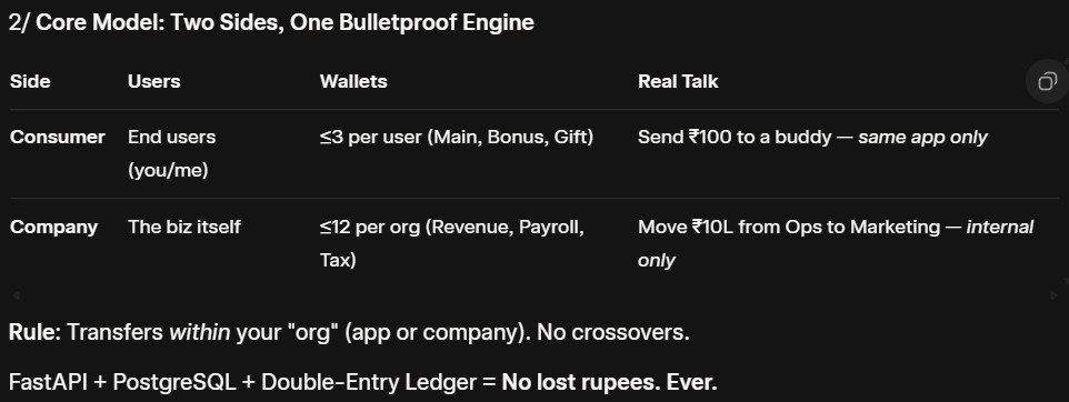
The "Money Never Lies" Problem
Building fintech? You've got two worlds to nail:
Users sending ₹ to friends (Paytm-style)
Companies shuffling budgets (Stripe Treasury vibe)
But how do you power both with zero data leaks, atomic transfers and full audit trails?
Enter VaultCraft
English
5/ But Wait — Is This Overkill? Or Genius?
I'm not a finance pro, so hit me:
Does the 3-wallet user cap feel right for UX? (Too few? Too many?)
12 for companies — covers payroll/marketing/tax? Missing any?
Cross-org settlements next? (e.g., Paytm → PhonePe)
English
4/ Why This Model Slaps (For Builders Like Us)
Consumer Side: Like Venmo, but you built the bank. No race conditions, even at 1k TPS.
Company Side: Internal ledgers that pass audits. Auto-sweeps (e.g., 15% to Tax)? Trivial.
Scalable AF: Outbox for Kafka events (Phase 2 incoming)
English
How a Transfer Actually Works (No Magic, Just DB Truth)
Invariants Enforced:
Debits = Credits (always)
Ledger = Source of Truth (balances just cache)
Multi-Tenancy: WHERE org_id = yours (zero leaks)
Reconciliation jobs catch any drift. Battle-tested with Pytest.

English


@sirmo @iyoushetwt Exactly! 💯 That's why you Python is the Goat 🔥
English

@IntrovertTechi I am on the same path, maybe I should drop a similar kind of post.
Hi, I am into development.
English

Proud to see my contribution (PR #141) highlighted by EvoAgentX 🙌.
Shipped Google Maps Toolkit — bringing geocoding, directions, distance matrix, and timezone lookups into AI agents.
Real-world intelligence for AI, now live.
EvoAgentX@EvoAgentX
✨ Exciting News: Google Maps Toolkit Now Live in EvoAgentX!github.com/EvoAgentX/EvoA… Harnessing location-aware intelligence just got easier. EvoAgentX now ships with a brand-new Google Maps Toolsuite — a powerful integration of Google Maps Platform APIs, now part of our core ready-to-use toolkit. This exciting contribution was spearheaded by Bhaskar Reddy (@Bhaskar-scientist), who submitted it via PR #141 to our EvoAgentX repository. A heartfelt thank-you for such a rich and practical enhancement to our framework! ----------- What Does the Google Maps Toolkit Do? Leveraging the baseline code in google_maps_tool.py, EvoAgentX agents can now perform real-world geospatial tasks seamlessly: • Geocoding & Reverse Geocoding — turn street addresses into lat/long coordinates, or interpret coordinates back to human-readable addresses. • Places Search & Place Details — run “pizza restaurants near me”, fetch ratings, contact info, open hours, reviews, etc. • Directions — compute routes between any two points using driving, walking, bicycling, or transit modes. • Distance Matrix — batch compute distances or travel times between sets of origins and destinations — perfect for logistics, delivery staging, nearest outlet searches. • Time Zone Lookup — get accurate timezone data for any coordinate, even with a historical timestamp parameter. All powered through GoogleMapsBase, handling request building, key management, error handling, response parsing — making development intuitive and robust. ----------- 🔗 Try it yourself: Tool source: github.com/EvoAgentX/EvoA… Usage example: github.com/EvoAgentX/EvoA… ----------- Why This Matters • Faster Prototyping: Need to build a delivery agent that picks the nearest hub? Or a chatbot that suggests top restaurants around your current location? This toolkit accelerates those builds. • Real-world intelligence: Embedding geospatial awareness means your agents don’t just talk — they locate. • Reliability & Graceful Errors: Handles Google API responses, zero results, errors — you get consistent outputs and clear error messages. Plus, it’s part of EvoAgentX’s vision: to offer a self-evolving agent platform where domain experts, data scientists, and developers can mix tools and logic in powerful ways. Thank you, Bhaskar Reddy (@Bhaskar-scientist) — your PR has unlocked location intelligence for the EvoAgentX community. Contributors like you are what make open source move forward! ----------- Developers — Let’s Build Together! Are you excited by this? Want to help shape the next generation of geospatial agents, intelligent routing systems, or location-based conversations? Here’s how you can pitch in: • Elevation API — unlock terrain-aware use cases like hiking route planners, drone pathing, flood-risk simulations. • Roads API — snap GPS traces to roads, detect nearest roads, or infer speed limits — useful for fleet tracking & mobility analytics. • Maps Static API — generate lightweight map thumbnails for chatbots, dashboards, or PDF reports. • Geospatial clustering / heatmaps — utilities to group and visualize places data, ideal for retail site selection or logistics density analysis. • Batch & edge-case support — high-volume geocoding, international address quirks, handling Google’s rate limits gracefully. • User-facing examples — Jupyter notebooks showing real workflows (logistics optimization, real-estate search, delivery cost estimation). Or more? Your code, your ideas, your improvements could be the next big leap for EvoAgentX. We’re building this together. Join us in making AI agents smarter, more connected to the physical world — faster than ever. #EvoAgentX #OpenSource #GoogleMaps #AIAgents #LocationIntelligence #GeoAI #CommunityDriven • ••
English
Just shipped Google Maps Toolkit into EvoAgentX (PR #141).
Agents can now:
Turn addresses ↔ coords
Find “pizza near me”
Compute travel time/distances
Get timezones
Location-aware AI just got easier.
Repo: github.com/EvoAgentX/EvoA…
#AI #Agents #OpenSource #Evoagentx #Google

English