Supreme WX

361 posts

Supreme WX banner
Supreme WX

Supreme WX

@SupremeShdw

My opinions are my own and not professional in any way, shape or form. Avid Hockey Fan (#LGP) Weather + Hockey... let it roll

Katılım Ocak 2025
55 Takip Edilen46 Takipçiler
Sabitlenmiş Tweet
Supreme WX
Supreme WX@SupremeShdw·
think they forgot something
Supreme WX tweet media
English
0
1
2
121
Supreme WX
Supreme WX@SupremeShdw·
LETS GO
GIF
English
0
0
0
18
Supreme WX
Supreme WX@SupremeShdw·
Lots of Southern Ontario are in a Slight risk (2/5) highlighted on the D3 Outlook by the SPC for Tuesday, with an all hazards setup possible. Not going to throw the "T" word out there yet though. Portions of the #GTA are also in a # risk that could be Sig Wind/Hail. #ONWx
Supreme WX tweet mediaSupreme WX tweet media
English
0
0
2
156
Supreme WX
Supreme WX@SupremeShdw·
@WickyDubs2 Really getting worried for what Hurricane Season might look like... especially because in one of the budgets proposed the abolishment of a certain NOAA division for "climate action" is the HRD that would cut recon down big time.. only going to lead to more injuries, dmg and death
English
0
0
1
86
Supreme WX
Supreme WX@SupremeShdw·
Category 5 #Errol has been such an impressive system. Jumping from a TS all the way to a Category 5 (that could have went sub 900 but without recon we will never know) The system only has a little bit before shear and dry air rip it apart.
Supreme WX tweet media
English
0
1
3
202
Supreme WX
Supreme WX@SupremeShdw·
@ViridWx Massive shame we dont have any recon outside of the NHC AOR... systems like this would be amazing to get recon into...
English
0
0
1
6
ViridWx
ViridWx@ViridWx·
The sat-ops on Knackwx just shows how utterly useless Dvorak Satellites are in tight-cored pinhole RI’s storms like this.
English
2
0
2
52
ViridWx
ViridWx@ViridWx·
Well it seems like Cyclone #Errol jumped the gun earlier today undergoing Explosive Intensification, embedded in a ULAC steering clear from dry air in 30C SST’s, it jumped from 55kts at 2PM EST yesterday to near C4 right now… and it still has time left to go even further.
ViridWx tweet mediaViridWx tweet mediaViridWx tweet media
English
1
1
5
202
Supreme WX
Supreme WX@SupremeShdw·
UPDATE - JTWC Subjective Dvorak has updated to reflect Category 4 Status (115kts/132mph). The eye is warming very fast and has plenty of time before the hostile environment takes over, no visible signs of an EWRC either. #Errol
Supreme WX tweet mediaSupreme WX tweet media
English
0
1
4
160
Supreme WX
Supreme WX@SupremeShdw·
@Sekai_WX I went... made a tea and all of a sudden the eye is warming rapidly... Nuts
English
0
0
0
37
Sekai Chandra
Sekai Chandra@Sekai_WX·
The eye just warmed 35 degrees Celsius in 30 minutes. This is the fastest I've seen an eye clear out in a TC in a very long time. ERI should continue unabated unless an EWRC gets it before shear increases tomorrow around midday.
Sekai Chandra tweet media
Sekai Chandra@Sekai_WX

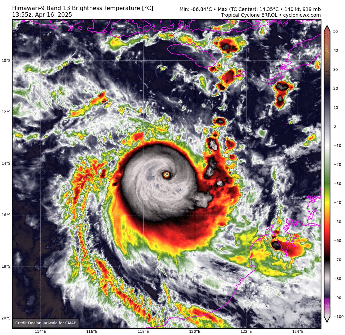
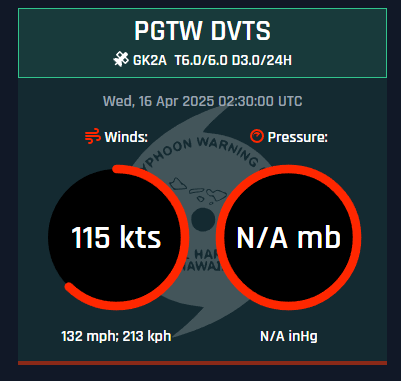
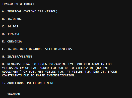
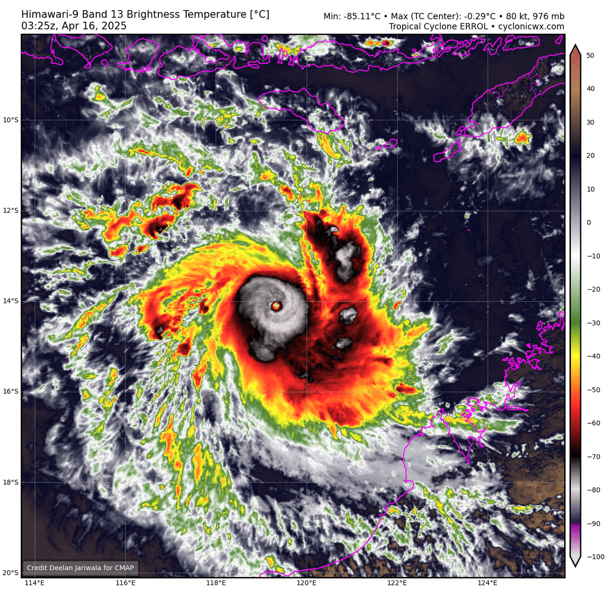
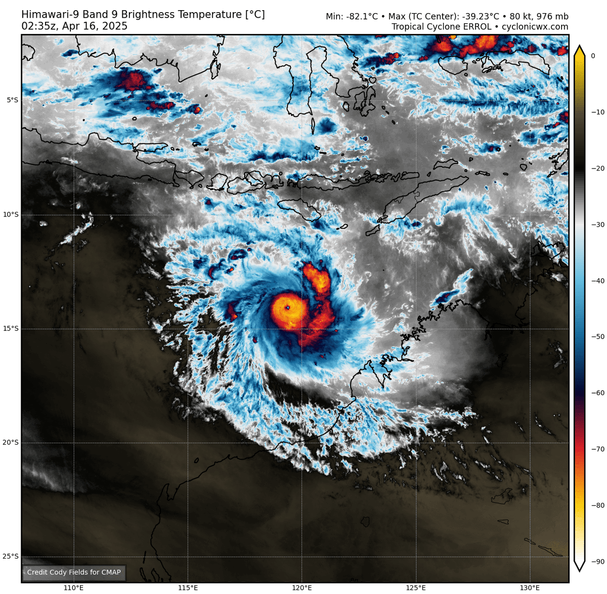
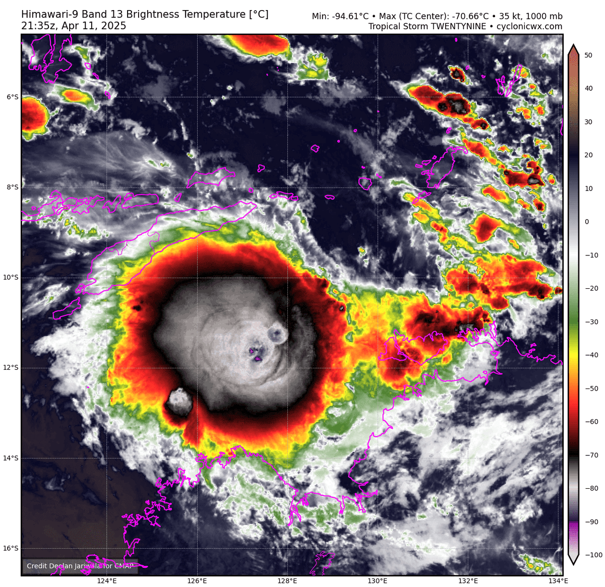
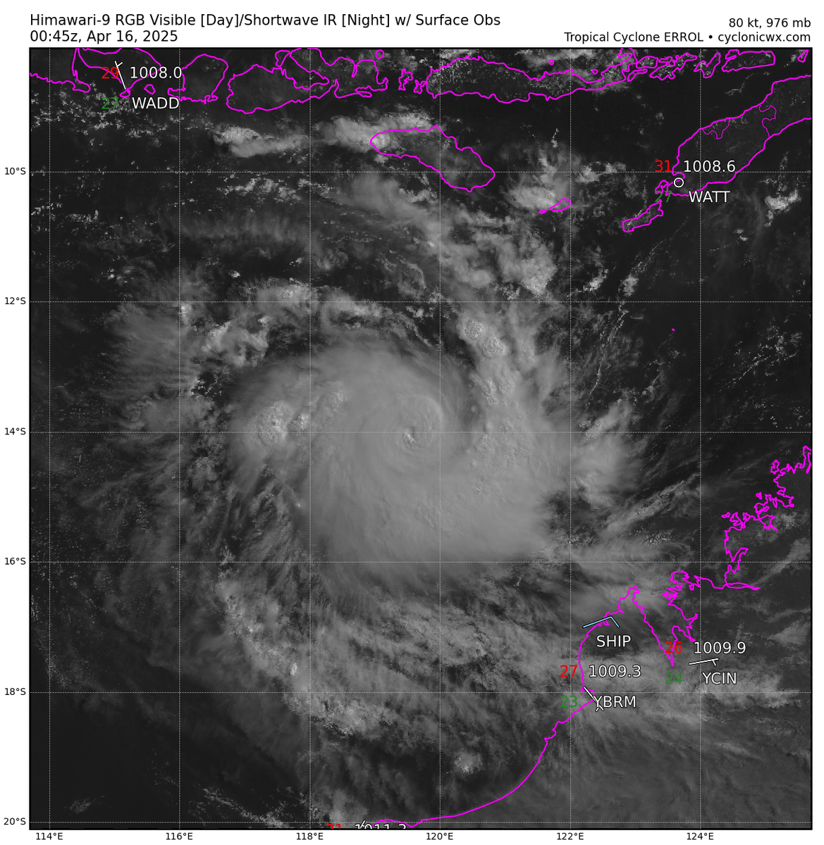
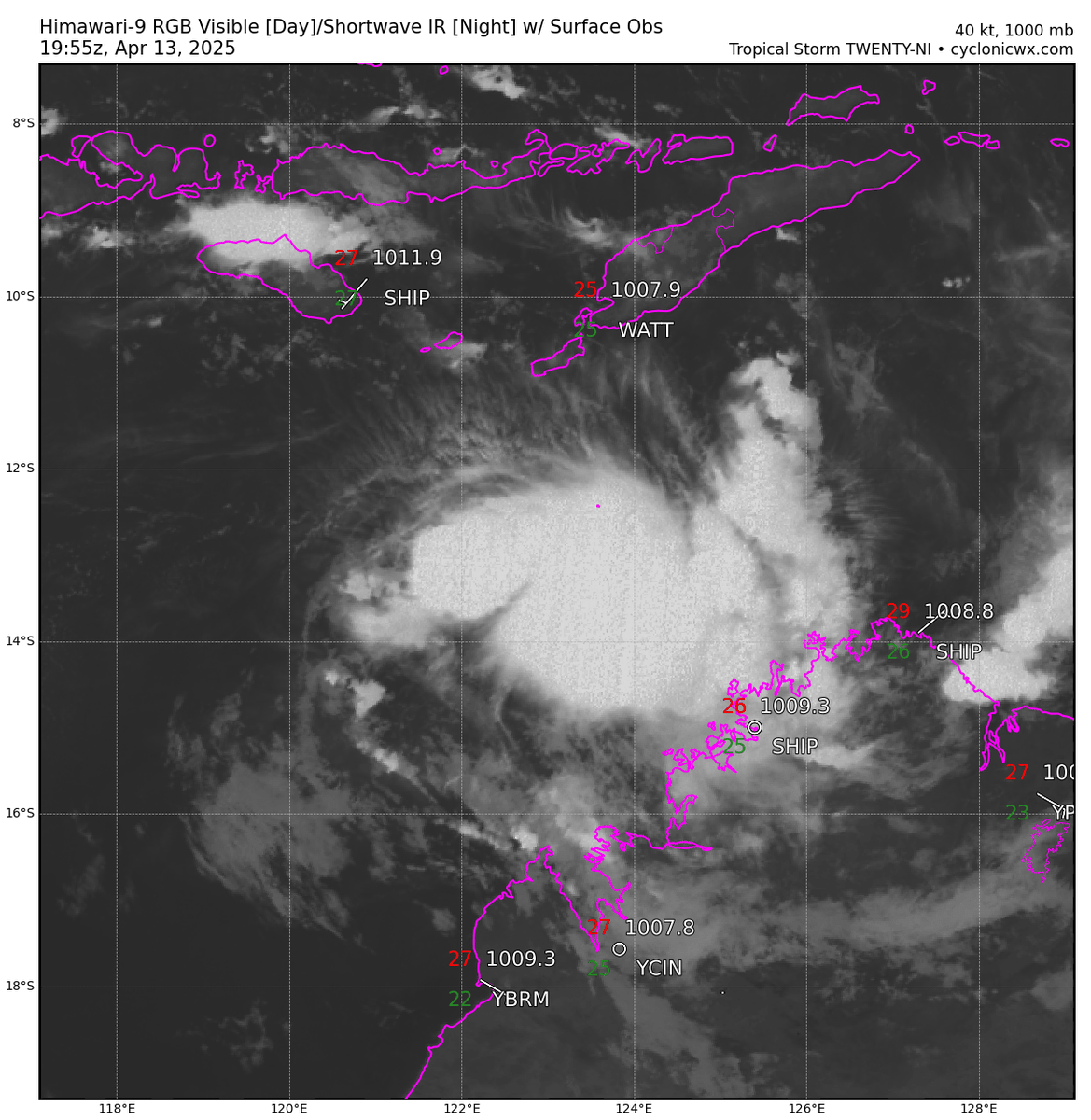
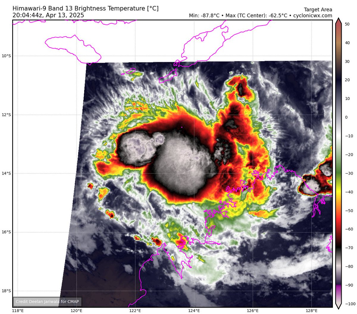
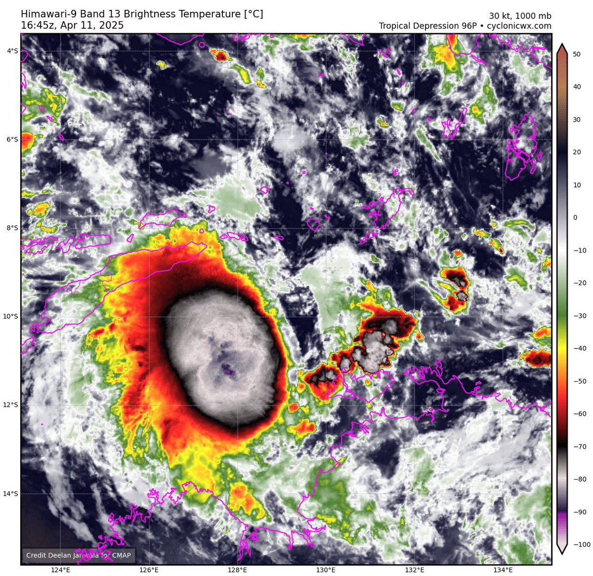
Very classic case of extreme rapid intensification (ERI) ongoing with Cyclone Errol NW of Australia right now. Smaller cores are very prone to rapid intensification, but they're also just as prone to falling apart and collapsing. Could make a C5 run if this keeps up.

English
2
3
30
2.1K
Supreme WX
Supreme WX@SupremeShdw·
Latest #JTWC advisory mentions an unofficial agency Dvorak has fixed it at 102kts but came out too late to be reflected, And how #Errol should continue to Rapidly Intensify for at least 12-24 hours before the hostile environment takes over, JTWC believes it hits 120kts+ as peak.
Supreme WX tweet media
English
0
0
1
112
Supreme WX
Supreme WX@SupremeShdw·
Wow... Extreme Rapid Intensification has and is taking place with cyclone #Errol with a Pinhole eye clearing out with plenty of deep convection in its CDO surrounding it. Definitely atMajor Hurricane strength as of right now and could make a runatC5 before the hostile environment
Supreme WX tweet mediaSupreme WX tweet mediaSupreme WX tweet mediaSupreme WX tweet media
English
0
1
4
196
Supreme WX
Supreme WX@SupremeShdw·
UPDDATE - Tropical Cyclone #Errol has been upgraded to 80kts/976mb (JTWC) as it is rapidly intensifying with a pinhole eye starting to clear out, It is likely to hit major status before encountering a very very hostile environment. #Cyclone
Supreme WX tweet mediaSupreme WX tweet mediaSupreme WX tweet media
English
0
0
1
101
Supreme WX
Supreme WX@SupremeShdw·
A very tiny eye is starting to poke out on #Errol and is a pinhole eye in nature that is likely not the actual size of it and its likely a bit bigger but has some overshooting cloud tops covering it, would be a beauty to get to see clear out. #Cyclone
Supreme WX tweet media
English
0
0
2
114
Supreme WX
Supreme WX@SupremeShdw·
@AlanSevere Would be nice if NRL wasnt down for SHEM storms atm to get a look at the MW for the small core...
English
0
0
1
46
Alan Snyder
Alan Snyder@AlanSevere·
Errol looks like it is starting it's process of intensification this morning. You can see vertical hot towers start to develop and warp around the center. could be indicative of an eye forming. It has about 20-24 hours to strengthen.
GIF
English
1
2
17
673
Supreme WX
Supreme WX@SupremeShdw·
Never change HAFS-A... Never change
Supreme WX tweet media
English
0
0
0
23
Supreme WX
Supreme WX@SupremeShdw·
HES DONE IT... RORY HAS DONE IT.. THE GRAND SLAMMMMMM
English
0
0
0
74
Supreme WX
Supreme WX@SupremeShdw·
RORY NOOO... Rooting for the guy in the playoff.. cmon Rory
English
0
0
0
408
Supreme WX
Supreme WX@SupremeShdw·
#29P continues to slowly organize and has done a slight bit of intensification today, hitting 40kts from the last JTWC Fix. Mid level shear is finally subsiding that has prohibited development over the last few days but it should have a good window to develop coming up. #Cyclone
Supreme WX tweet mediaSupreme WX tweet media
English
0
0
1
30
Supreme WX
Supreme WX@SupremeShdw·
Despite having low-moderate overall shear from CIMSS Analysis and The Australian BOM Report, some moderate-high wind shear in the mid levels is displacing the vortex from the overall convection with our LLC being just on the northernmost extent covered by some cirrus flow.
Supreme WX tweet media
English
0
0
1
32
Supreme WX
Supreme WX@SupremeShdw·
This is honestly one of the better environments I have seen in a while that Tropical Storm 29 could take advantage of, decreasing mid level shear with its track and very warm SSTs with a good subsurface profile and decent RH levels. definitely going to be one to watch. #hurricane
Supreme WX tweet mediaSupreme WX tweet mediaSupreme WX tweet mediaSupreme WX tweet media
English
0
1
7
361
Supreme WX
Supreme WX@SupremeShdw·
Tropical Depression #96P in the Australian region is likely a tropical storm right now with ASCAT getting winds of 40kts without accounting for underdoing the winds. This could go and become a major #cyclone possibly down the line.
Supreme WX tweet mediaSupreme WX tweet media
English
0
0
4
151