Matt Schaefer - WQOW 18 News ⛈️

6.5K posts

Matt Schaefer - WQOW 18 News ⛈️ banner
Matt Schaefer - WQOW 18 News ⛈️

Matt Schaefer - WQOW 18 News ⛈️

@TheWeatherMatt

Chief Meteorologist for @WQOW News 18 in Eau Claire, WI. Born & Raised in Sheboygan, WI. @ValpoU Alumnus

Eau Claire, WI Katılım Eylül 2014
167 Takip Edilen685 Takipçiler
Matt Schaefer - WQOW 18 News ⛈️
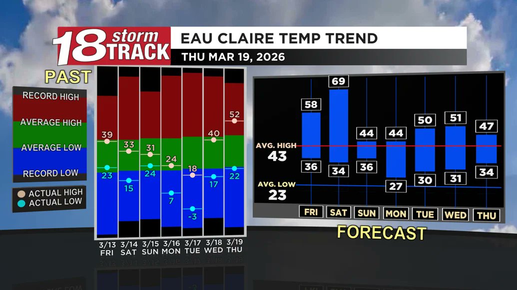
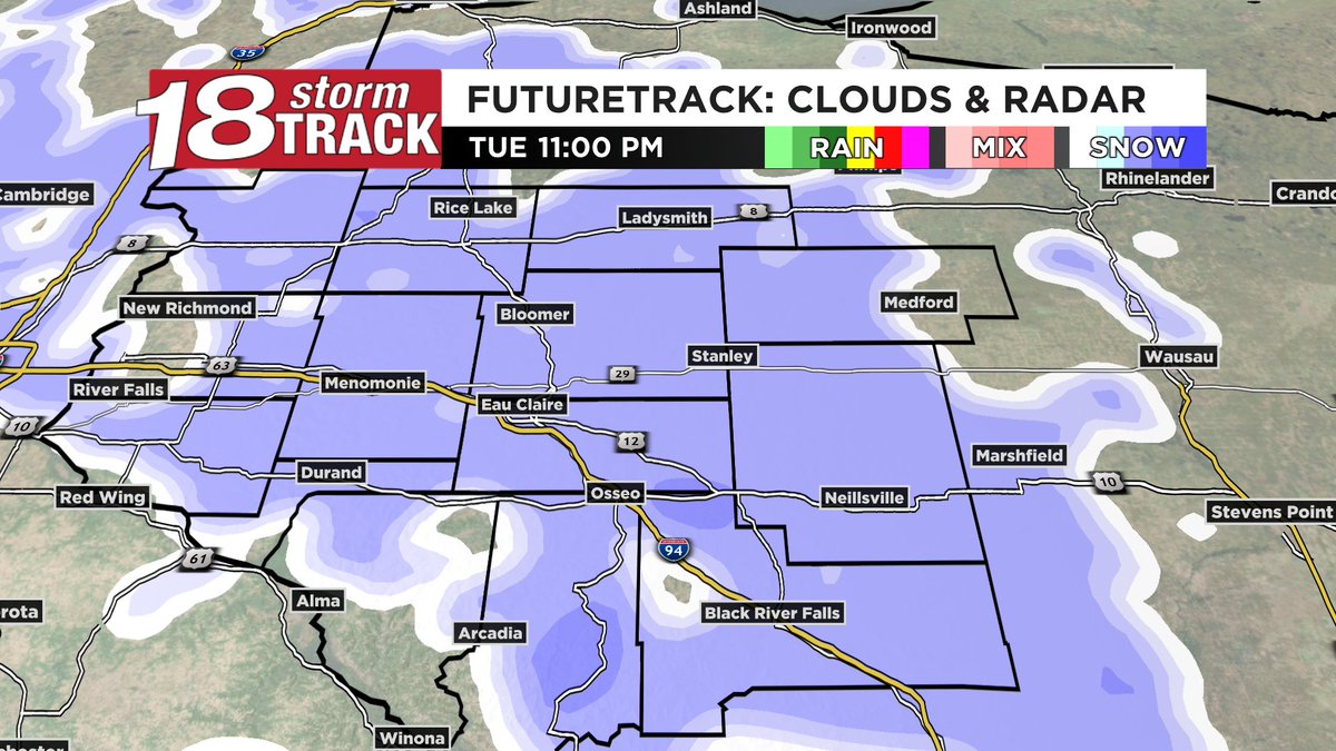
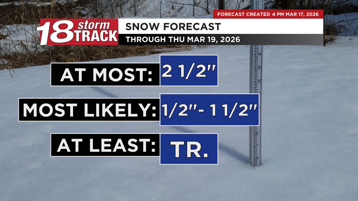
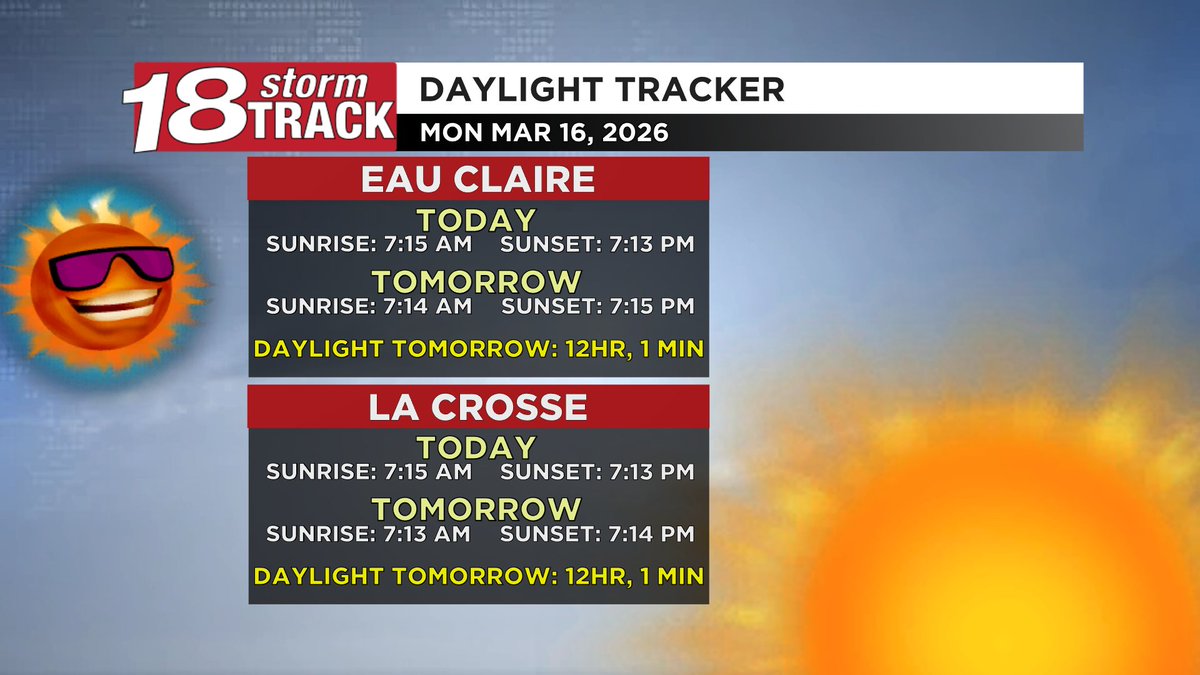
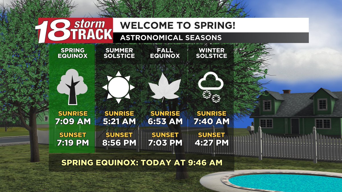
Today is the spring equinox, and it felt like spring! It'll be even warmer tomorrow with a chance at hitting or exceeding 70° for the first time this year. There is a chance for rain/snow/mix early Sunday morning as a cold front moves through. Details: wqow.com/weather/astron…
Matt Schaefer - WQOW 18 News ⛈️ tweet mediaMatt Schaefer - WQOW 18 News ⛈️ tweet media
English
0
0
5
103
Matt Schaefer - WQOW 18 News ⛈️
Temps will go from the negatives Tuesday morning to at least the mid 60s with a chance at the low 70s Saturday afternoon. A cold front will then move through early Sunday morning with a chance for rain and/or snow. Details: wqow.com/weather/even-w…
Matt Schaefer - WQOW 18 News ⛈️ tweet media
English
0
0
0
75
Matt Schaefer - WQOW 18 News ⛈️
Warmer temps are on the way! Expect a lot of melting over the next few days (along with chances for rain/wintry mix). You can help reduce standing water & icy spots on roads/driveways by giving the water a place to go: consider clearing a path to storm drains or drainage ditches
Matt Schaefer - WQOW 18 News ⛈️ tweet mediaMatt Schaefer - WQOW 18 News ⛈️ tweet mediaMatt Schaefer - WQOW 18 News ⛈️ tweet media
English
0
1
1
105
Matt Schaefer - WQOW 18 News ⛈️
A round of snow will move through tonight and should be out by early morning. Still, a few slick spots are possible for the AM commute. Warmer temps will follow tonight's system, and the next couple precip chances should be at least mostly rain. Details: wqow.com/weather/warmer…
Matt Schaefer - WQOW 18 News ⛈️ tweet mediaMatt Schaefer - WQOW 18 News ⛈️ tweet media
English
0
0
3
412
Matt Schaefer - WQOW 18 News ⛈️
Tomorrow will have more than 12hrs of daylight for the 1st time this year! This happens before the equinox for 2 reasons: 1) we define sun rise/set as when the top of the sun touches the horizon not the center, and 2) light bends upwards when the sun is low in the sky.
Matt Schaefer - WQOW 18 News ⛈️ tweet media
English
0
1
1
120
Matt Schaefer - WQOW 18 News ⛈️
Travel will be DANGEROUS TO IMPOSSIBLE once snow starts this evening through at least Monday morning. If you must work, I’d encourage you to pack and go today and spend the night. Infrastructure damage/power outages are also possible.
Matt Schaefer - WQOW 18 News ⛈️@TheWeatherMatt

*BLIZZARD WARNING* This is only Western Wisconsin’s 5th blizzard warning since 2006. While the winds may not quite maintain the 35+ mph requirement of a blizzard, visibility will be near zero with snow rates of 1 to 4 inches per hour bringing the potential for historic totals.

English
0
3
3
402
Matt Schaefer - WQOW 18 News ⛈️
*BLIZZARD WARNING* This is only Western Wisconsin’s 5th blizzard warning since 2006. While the winds may not quite maintain the 35+ mph requirement of a blizzard, visibility will be near zero with snow rates of 1 to 4 inches per hour bringing the potential for historic totals.
Matt Schaefer - WQOW 18 News ⛈️ tweet media
English
0
2
3
591
Matt Schaefer - WQOW 18 News ⛈️
Please take the time to read my extended write-up or watch my forecast video. Basically, ridiculous snow totals are possible where precip stays all snow. Elsewhere, freezing rain and wintry mix could cause icy roads before lesser totals add up. Details: wqow.com/weather/weeken…
Matt Schaefer - WQOW 18 News ⛈️ tweet mediaMatt Schaefer - WQOW 18 News ⛈️ tweet media
English
1
2
4
1.1K
Matt Schaefer - WQOW 18 News ⛈️
Totals aren't the important part of the forecast because, regardless if it's 8" or 18", it'll be enough to cause major travel issues especially when combined with wind/near zero visibility. Please cancel any travel plans Sat. eve. through Mon. AM.
Matt Schaefer - WQOW 18 News ⛈️@TheWeatherMatt

WINTER STORM WARNING: Saturday night through Monday morning. Accumulations have a chance (not guaranteed) to make Eau Claire's all-time list. I'll have a more detailed total forecast coming out later this afternoon.

English
0
1
3
443
Matt Schaefer - WQOW 18 News ⛈️
WINTER STORM WARNING: Saturday night through Monday morning. Accumulations have a chance (not guaranteed) to make Eau Claire's all-time list. I'll have a more detailed total forecast coming out later this afternoon.
Matt Schaefer - WQOW 18 News ⛈️ tweet mediaMatt Schaefer - WQOW 18 News ⛈️ tweet media
English
0
2
3
758
Matt Schaefer - WQOW 18 News ⛈️
Here's another way to look at the weekend's winter storm. It seems like whether we get 8" or 18"+, there will be enough snow to make travel dangerous to impossible especially when combining heavy snow rates with wind which cause near 0 visibility.
Matt Schaefer - WQOW 18 News ⛈️ tweet media
English
0
2
4
487
Matt Schaefer - WQOW 18 News ⛈️
TRAVEL NOT ADVISED once snow begins Saturday evening likely after sunset through at least Monday morning. If we get the high end totals that are possible but not guaranteed, side streets may be impassible or at least have difficult travel through Monday.
Matt Schaefer - WQOW 18 News ⛈️ tweet mediaMatt Schaefer - WQOW 18 News ⛈️ tweet mediaMatt Schaefer - WQOW 18 News ⛈️ tweet mediaMatt Schaefer - WQOW 18 News ⛈️ tweet media
English
0
0
3
1.2K
Matt Schaefer - WQOW 18 News ⛈️
TONIGHT: Very windy with a mix of rain and snow. Gusts to 50 mph possible. Rusk and Taylor Counties can expect 3-7" snow. 1-4" for Barron, Chippewa, and Clark. Less than 1/5" for the rest of Western Wisconsin.
Matt Schaefer - WQOW 18 News ⛈️@TheWeatherMatt

THIS WEEKEND: Heavy snow & gusty winds are likely: WINTER STORM WATCH in effect for the likelihood of 6"+ accumulations with a chance at 12"+ in some spots. Blizzard or near blizzard conditions are possible. TRAVEL IS NOT ADVISDED Sat eve. through Mon AM: PLEASE make other plans.

English
0
1
0
187
Matt Schaefer - WQOW 18 News ⛈️
THIS WEEKEND: Heavy snow & gusty winds are likely: WINTER STORM WATCH in effect for the likelihood of 6"+ accumulations with a chance at 12"+ in some spots. Blizzard or near blizzard conditions are possible. TRAVEL IS NOT ADVISDED Sat eve. through Mon AM: PLEASE make other plans.
Matt Schaefer - WQOW 18 News ⛈️ tweet mediaMatt Schaefer - WQOW 18 News ⛈️ tweet media
English
0
2
0
291
Matt Schaefer - WQOW 18 News ⛈️
Light to moderate snow rates are likely tonight into tomorrow morning. Areas with higher forecast snow totals will see snow last longer as opposed to having heavier rates, and that's more likely further north where it's been snowing or will soon begin to snow.
Matt Schaefer - WQOW 18 News ⛈️ tweet mediaMatt Schaefer - WQOW 18 News ⛈️ tweet media
English
0
1
1
194
Matt Schaefer - WQOW 18 News ⛈️
HAPPY MAR10 DAY! Temps tonight will get cold enough for a wet/slushy snow. WINTER WEATHER ADVISORY is in place until 1 PM tomorrow for snow that could exceed the high end of my forecast totals from last night. I'm working on an updated forecast and will have that this evening.
Matt Schaefer - WQOW 18 News ⛈️ tweet mediaMatt Schaefer - WQOW 18 News ⛈️ tweet media
English
0
1
1
200
Matt Schaefer - WQOW 18 News ⛈️
Snow/ mix will be possible as early as tomorrow AM, though shouldn't be widespread until tomorrow night, ending Wed. AM. The higher totals are most likely to be north of WIS-29. This is the first of several rounds of wintry precip this week, details: wqow.com/weather/eau-cl…
Matt Schaefer - WQOW 18 News ⛈️ tweet mediaMatt Schaefer - WQOW 18 News ⛈️ tweet mediaMatt Schaefer - WQOW 18 News ⛈️ tweet media
English
0
2
2
515