
WAVE Weather
51.5K posts

WAVE Weather
@WAVE3Weather
The WAVE Storm Tracking Team is the only team you need to stay updated in breaking and severe weather in WAVE Country.
Louisville, KY Katılım Ekim 2011
41 Takip Edilen18.4K Takipçiler
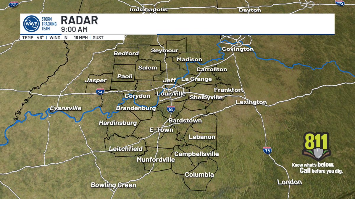
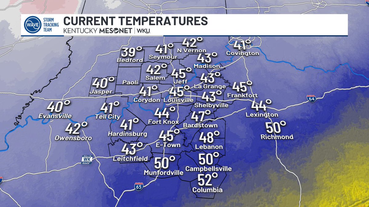
Good morning! Here are your out-the-door temps around WAVE Country. Catch the forecast now on #WAVENews Sunrise!
#WAVEWeather app: onelink.to/7ysptn
English
WAVE Weather retweetledi

Much cooler weather around for our Monday! We'll see highs in the low to mid-50s afternoon; much more sunshine is expected for the second half of the day.

English
[1:05AM MONDAY] The severe weather threat is over! Any lingering storms will exit over the next 1 to 2 hours and are not expected to turn severe. Sleep well!

English
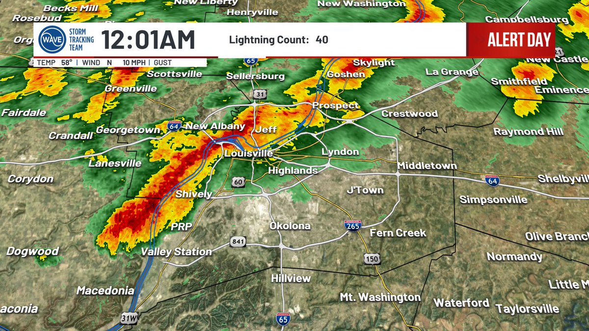
[12:01AM MONDAY]: A quick burst of heavy rain and lightning is now moving into Louisville! We'll watch for gusty winds and perhaps some small hail but no storms are severe at this time. Storms exit the region by 2AM.
English
SEVERE T-STORM WARNING for Jackson, Jennings, Decatur until 3/22 11:30PM EDT. Stay indoors! #WAVEWeather app: qrco.de/bcAP8x

English
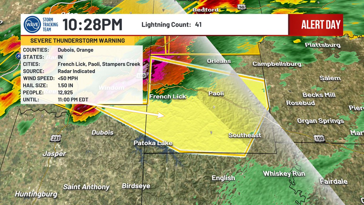
SEVERE T-STORM WARNING for Orange, Dubois until 3/22 11:00PM EDT. Stay indoors! #WAVEWeather app: qrco.de/bcAP8x
English
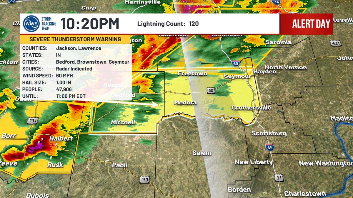
SEVERE T-STORM WARNING for Jackson, Lawrence until 3/22 11:00PM EDT. Stay indoors! #WAVEWeather app: qrco.de/bcAP8x
English
SEVERE T-STORM WARNING for Bartholomew, Johnson, Decatur, Jackson, Brown, Jennings, Monroe, Shelby until 3/22 11:00PM EDT. Stay indoors! #WAVEWeather app: qrco.de/bcAP8x

English
Alert Day Special Update - 10:10PM Sunday, 3/22/26 x.com/i/broadcasts/1…
English
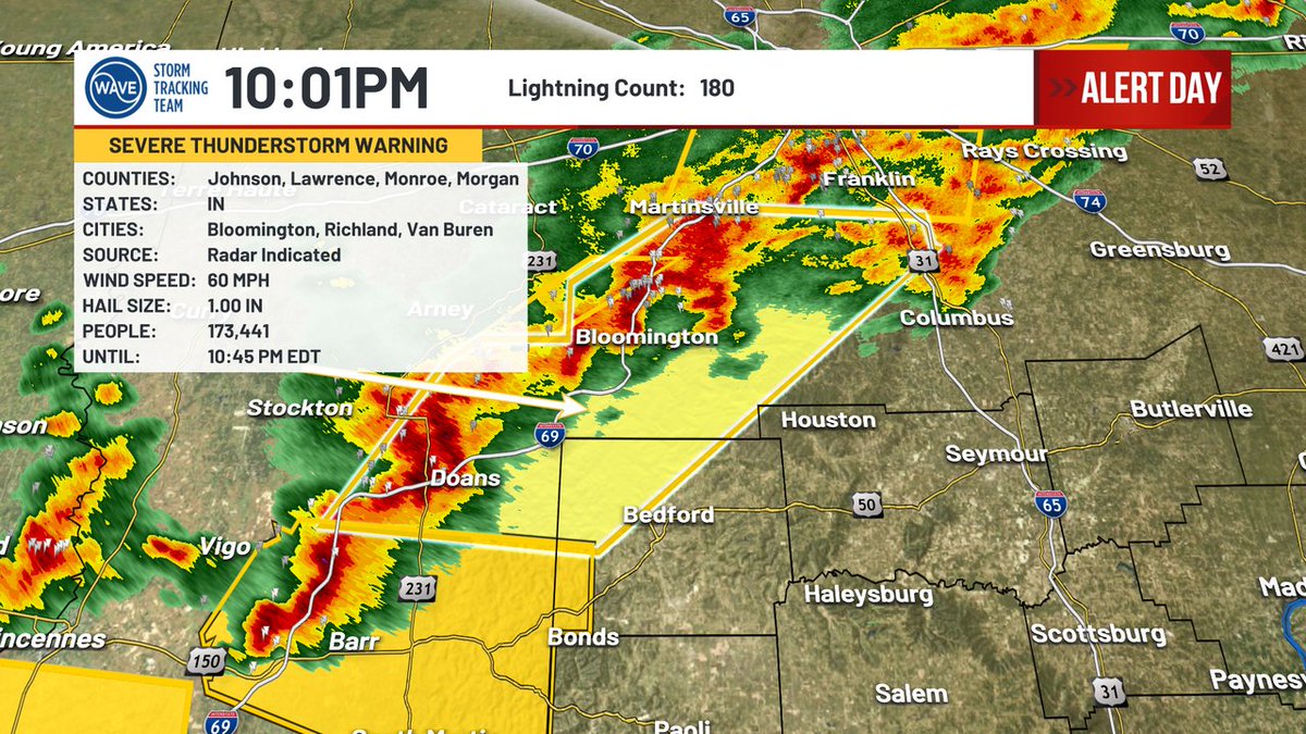
SEVERE T-STORM WARNING for Monroe, Johnson, Morgan, Lawrence, Brown, Daviess, Greene, Martin, Bartholomew until 3/22 10:45PM EDT. Stay indoors! #WAVEWeather app: qrco.de/bcAP8x
English
SEVERE T-STORM WARNING for Daviess, Martin, Lawrence until 3/22 10:45PM EDT. Stay indoors! #WAVEWeather app: qrco.de/bcAP8x

English
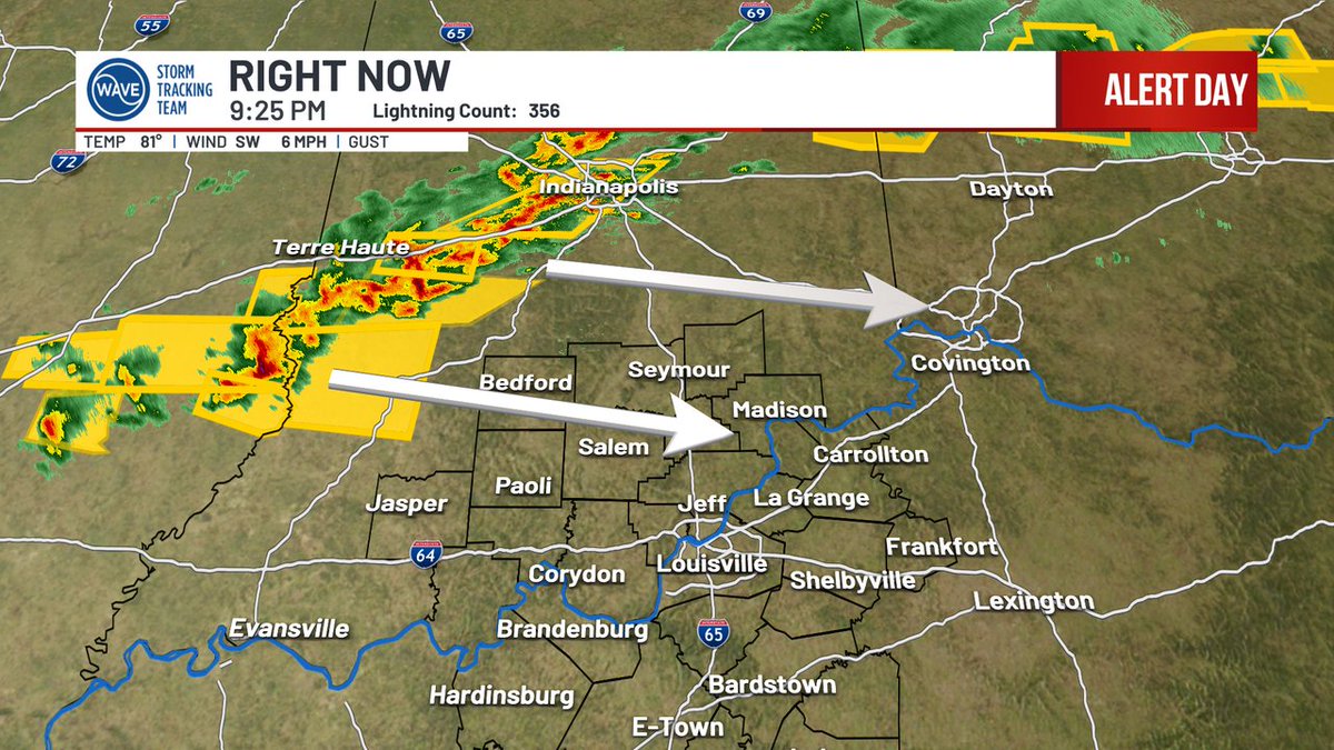
[9:25PM SUNDAY]: The line of severe storms in central Indiana is approaching our area. Mostly small hail (pea or nickel size) has been reported so far but the risk for larger hail and gusty wind continues. Warnings are possible in our Indiana counties near or just after 10PM.
English
Alert Day Special Update - 7:50 PM Sunday, 3/22/26 x.com/i/broadcasts/1…
English
Severe Thunderstorm WATCH issued for the counties shaded in yellow until 3/23 1:00AM EDT. #WAVEWeather app: ul.ink/1K36BT

English
Severe Thunderstorm WATCH issued for the counties shaded in yellow until 3/23 1:00AM EDT. #WAVEWeather app: ul.ink/1K36BT

English
[5:04PM SUNDAY]: A watch (likely Severe T-Storm) may be needed north of I-64 later this evening. The SPC will wait to see if and when storms develop before a watch is considered. Large hail and gusty winds remain the primary concerns.

English
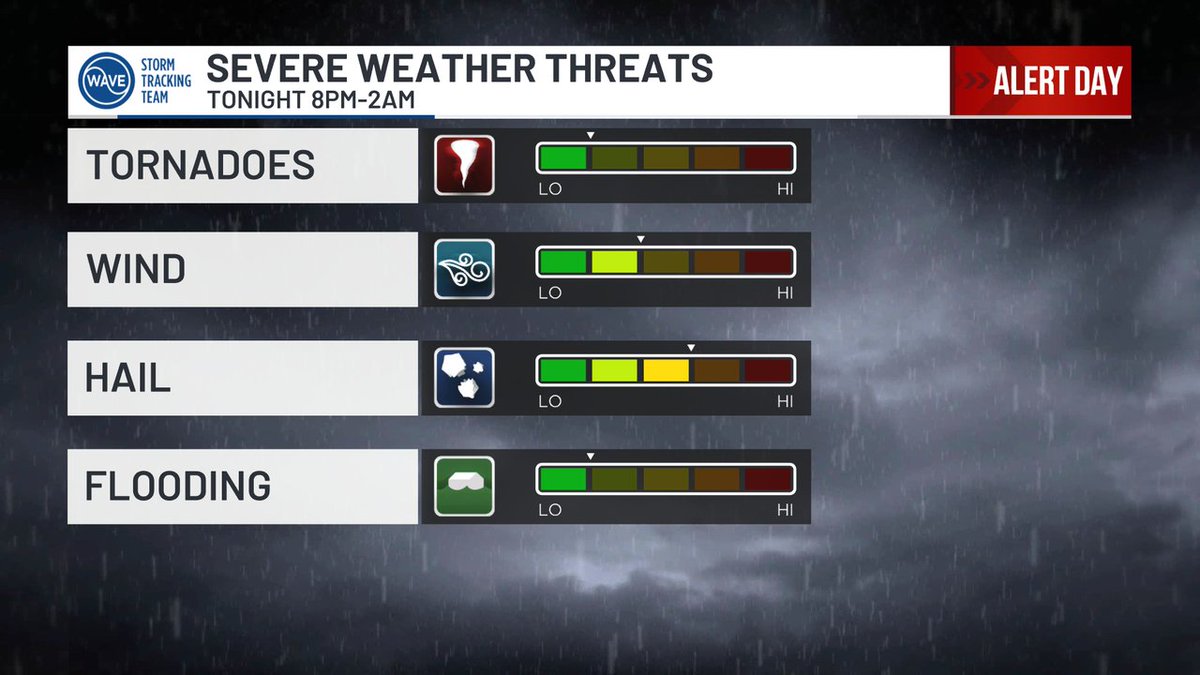
ALERT DAY: Strong to severe storms are possible between 8PM and 2AM tonight. Large hail and gusty winds are the main threats. Most storms will be BEHIND the cold front, which will help to limit the tornado risk.
English
