@DOWFacility I should also note, the DOW8 data was marked as DOW7, due to it using DOW7's radar dish and configurations while being on the truck of DOW8 for this mission!
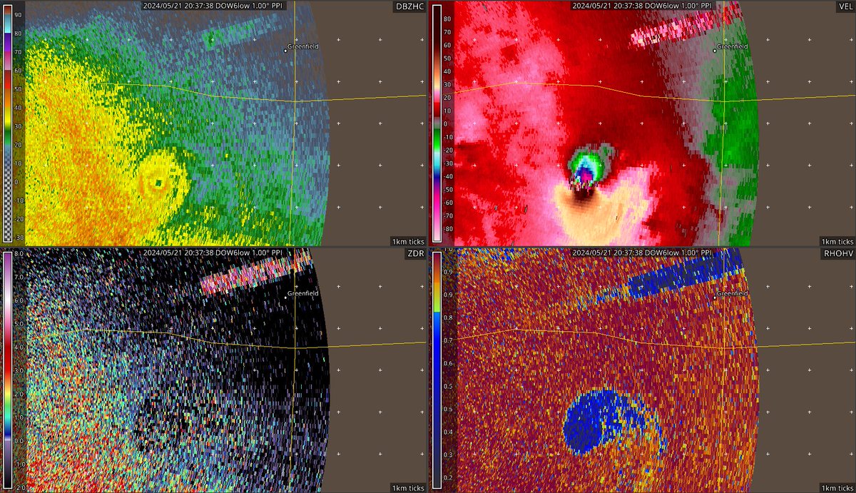
Two years ago: @DOWFacility using two mobile radars, DOW6 and DOW8 would sample a violent EF4 tornado that tore through the town of Greenfield, Iowa. 309-318 mph winds would be recorded several hundred feet up in this tornado.
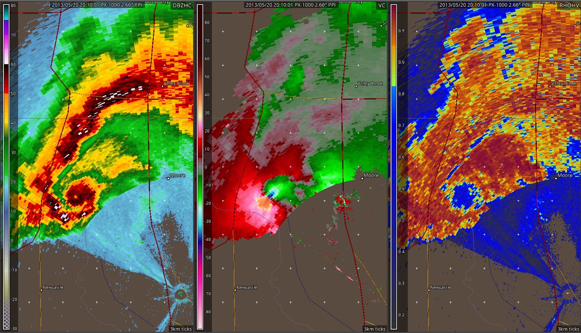
On this day 13 years ago: A powerful EF5 tornado tore through Moore, Oklahoma on May 20, 2013. OU ARRC's PX-1000 Mobile Radar captured this storm throughout the whole lifecycle, doing a full scan every 20 seconds!
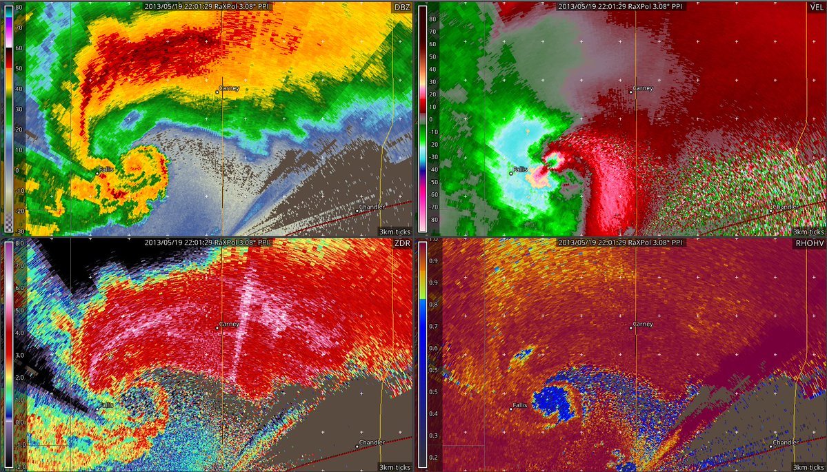
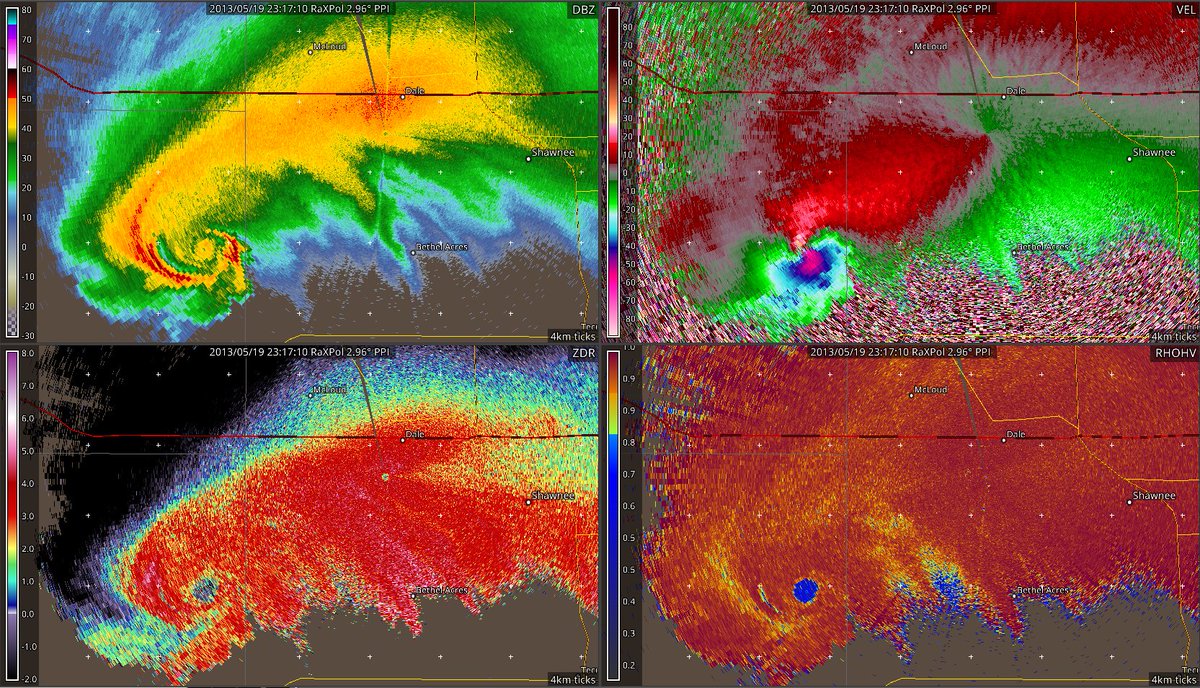
13 Years Ago: May 19, 2013, RaXPol would sample multiple tornadoes, the Carney, OK EF3 (first pic), and the Shawnee, OK EF4. RaXPol velocity data recorded around 200mph on the Shawnee Tornado on the lower levels. Data credit OU ARRC. Great Day!
November 2013: Typhoon Haiyan would strike the Philippines as one of the strongest storms in history, winds estimated to be 195mph at landfall.
This radar image is the last scan from the radar in Guiuan before it was knocked offline. Velocity data is unavailable.
@YoungWx07 DOW data can be requested here: farmfacility.org/contents/facil…
RaXPol data you usually email them, nowadays it's impossible to get unfortunately, but there are some datasets circulating out there like Sulphur, OK 2016. Hope this info helps in a way.
@adennison2009 Also another quick question, on some of your other posts, you have archived mobile radar imagery from past events. Is there a way to access that?
@YoungWx07 I used files that were coming in from a software called GURU2 (svr.guru), and converted it into a format GR2 can read, and I use a customradars.gis file that can plot the radar site location, and gives me the ability to load the converted data.
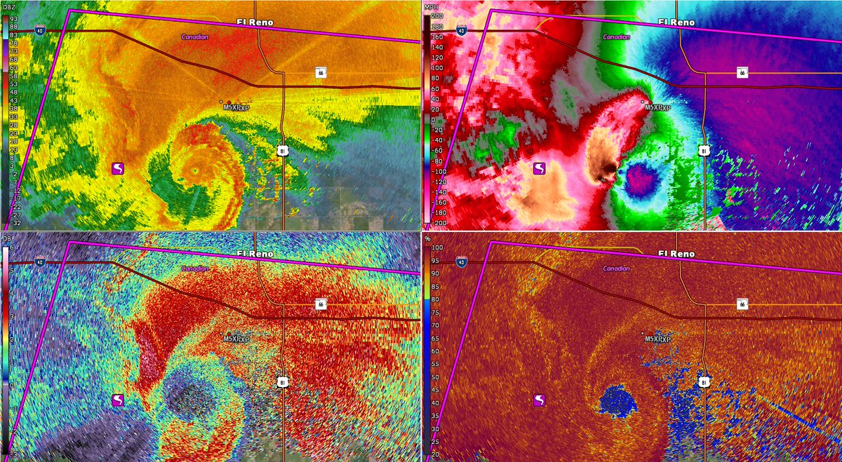
12 Years ago, May 31, 2013, the El Reno Tornado would touch down, becoming the widest tornado ever recorded (2.6 miles wide). Unfortunately, this would kill 4 storm chasers, 3 were from the TWISTEX team which included storm chaser Tim Samaras. Below is RaXPol data of the tornado.
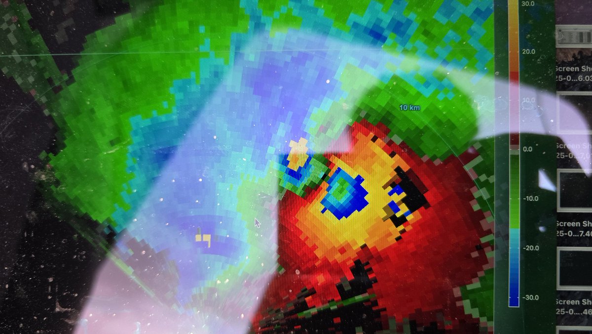
A radar scan viewed from DOW3 as the 2004 Harper, Kansas tornado directly impacted the farmstead at high-end F4 intensity. Thanks to the folks at FARM at the University of Illinois for providing me this data. Instantaneous(?) winds of 160-190 mph were occurring here 77 ft ARL.
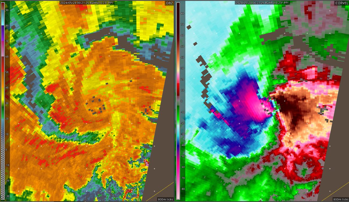
May 23, 2024, RaXPol was near Eldorado, OK scanning an EF2 tornado near Duke, OK. The tornado passed close to RaXPol and winds were most likely over 200mph according to multiple doppler radars. The DOW's were also scanning this strong tornado. Note the satellite tornado on DOW.
1 year ago - May 21, 2024, a violent EF4 Tornado would strike the town of Greenfield, Iowa. Two Doppler on Wheels were on site scanning this tornado as it went through town. As a result, windspeeds around 309 - 318mph were recorded. Below is data from DOW6 that day.