Published before the United States entered World War II, it shows how military planners viewed domestic industry as a key part of national preparedness.
This route is designed to pass through all 48 contiguous U.S. states as efficiently as possible, touching each state without trying to visit every capital, landmark or major city. The result is a 113-hour drive that links the Northeast, Southeast, Midwest, Plains, Rockies and Pacific Northwest into one giant lower-48 loop.
These patterns reflect long-term climatology rather than what will happen in any single year, so even lower-risk areas can still see damaging tornadoes.
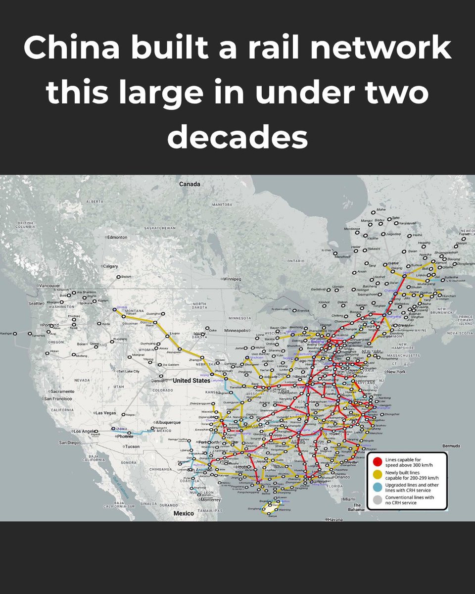
China opened its first high-speed passenger line in 2008. Less than two decades later, it had built the world’s largest high-speed rail network, stretching tens of thousands of kilometres across the country. Overlaid on North America, the scale becomes much easier to grasp.
Australia was once part of Gondwana, the ancient southern supercontinent, while the eastern United States followed a different tectonic path. The neat fit here is mostly a visual coincidence caused by rotation, scale and placement. But there is a surprising geological footnote: rocks in northern Queensland have been linked to ancient North America, suggesting a small piece of what is now Australia may once have been connected to Laurentia, the old core of North America, around 1.7 billion years ago.
During the golden age of piracy, the Atlantic coast of North America and the Caribbean were home to some of the most notorious pirates in history. This illustrated map places famous names such as Blackbeard, Anne Bonny, Mary Read, Calico Jack and William Kidd alongside the flags associated with them, showing how pirate geography, legend and visual identity became tightly linked in popular memory.
Polynesian migration was one of the great achievements of human exploration. Over thousands of years, Austronesian-speaking peoples moved from Taiwan into Island Southeast Asia and out across the Pacific, reaching places such as Samoa, Tonga, Tahiti, Hawaiʻi, Rapa Nui and New Zealand. These journeys required exceptional seafaring knowledge, with navigators reading stars, winds, currents, birds and ocean swells to cross vast distances between tiny islands.
Reddit user AMLT1983 spent years collecting soil from all 50 U.S. states to make this map. Some samples came from state agencies, parks and historical sites, while others were mailed by strangers who included handwritten notes about their state. The final missing pieces were collected on a road trip with their son. What started as a strange dirt project became a map shaped by generosity, travel and thousands of miles of American stories.
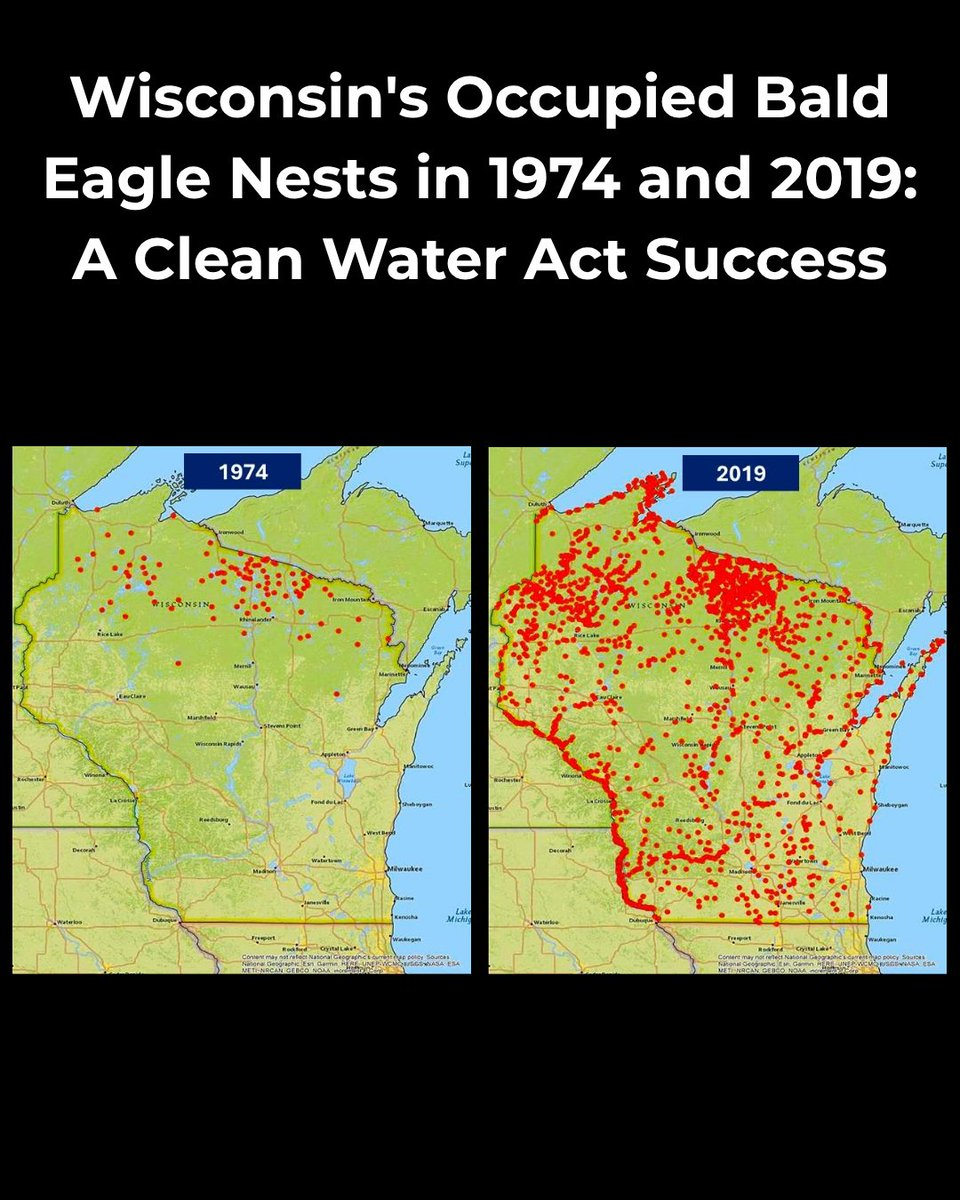
In 1974, occupied bald eagle nests in Wisconsin were mostly limited to the north of the state. By 2019, they had spread widely across Wisconsin. The recovery followed decades of conservation work, including the ban on DDT, stronger habitat protections and cleaner waterways that helped eagle populations rebound.
This map shows the world using only the boundaries of time zones. The outlines look strange because time zones are not just neat slices of longitude. In theory, each one-hour zone would cover about 15 degrees, but in practice they bend around countries, borders, islands, trade links and political choices. Even with coastlines and country borders removed, the world is still recognisable because time zones are shaped by geography, politics and convenience.
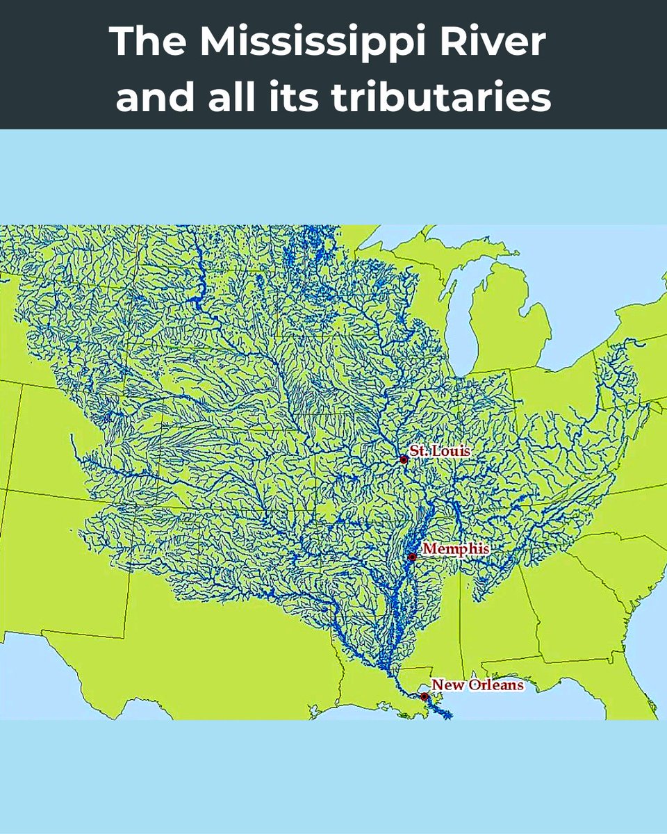
The Mississippi River is fed by thousands of tributaries, forming one of the largest drainage systems in the world. Its basin covers much of the central United States, carrying water from the Rockies, Appalachians, Great Lakes region and Gulf Coast toward the Gulf of Mexico.
On July 4, 1776, the United States consisted of 13 former British colonies along the Atlantic coast: New Hampshire, Massachusetts, Rhode Island, Connecticut, New York, New Jersey, Pennsylvania, Delaware, Maryland, Virginia, North Carolina, South Carolina, and Georgia. Many of their borders and western land claims were still unsettled, while the rest of what is now the U.S. remained outside the new country’s control.