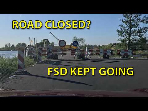
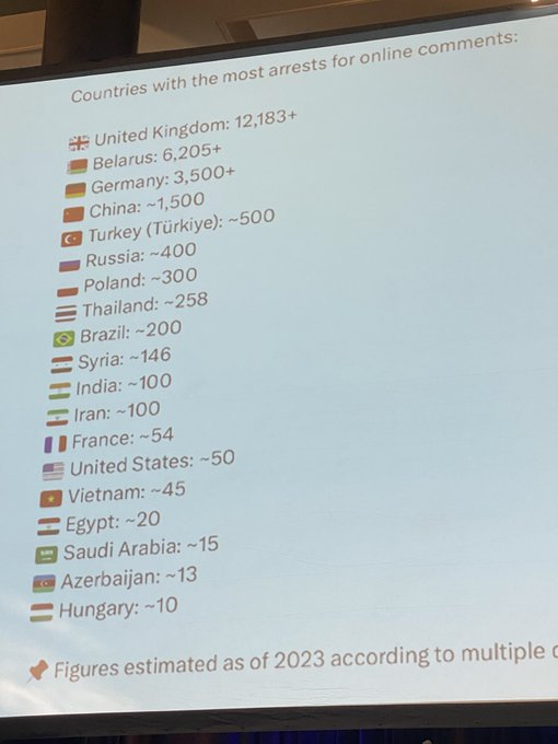


Anders S ☀️🌬💧+🔋=🌍
39.6K posts

@asoderqvist
Huge fan of Elon Musk & all his companies! Former Tesla Model X and M3P owner, now owner of MY LR and a MS Plaid 🚀 Use my referal link when buying a Tesla👍🏻


🚨 Iran just launched a MAJOR DRONE ATTACK and set a NUCLEAR POWER PLANT on fire in the United Arab Emirates! FAFO coming soon.


Update on my experience Grok Build. The team at @xai made an update, while I was sleeping, and I can already see the difference. Yesterday, I couldn't get Grok Build to run for more than a minute or two. I literally wake up this morning, see that the team made an update, and now everything I'm doing in Grok Build is running, and running, and running, until it finishes. I'm pretty sure nobody at xAI slept last night, and the end result is Grok Build is 10x better than it was a day ago. What happens over the next week is going to be wild. Now I'd say the beta has gone from a 6/10 to an 8/10, in a freakin' day 😅

Det finns ingen i världen som kan övertyga mig att en miljardär arbetar nära 10 000 ggr så hårt som en vanlig arbetare.


Tesla FSD V14.3.3 just started rolling out, and it comes with the Spring Update! Actually Smart Summon’s top speed has also been increased to 8 mph (from 6 mph)! Downloading it on my Model Y right now. Software version 2026.14.6.6.


What $1000 in $TSLA at IPO would be worth today 🤯

Google Maps Satellite Imagery of Palisades Fire Area Reverts to Pre-Disaster Views Amid Mayoral Race Scrutiny Pacific Palisades, CA Residents and observers are raising questions after Google Maps satellite imagery of areas devastated by the January 2025 Palisades Fire appears to have reverted to pre fire conditions, more than 16 months after the blaze. The Palisades Fire, which erupted on January 7, 2025, in the Santa Monica Mountains, became one of the most destructive wildfires in Los Angeles history. The fire burned over 23,000 acres, destroyed thousands of structures across Pacific Palisades, Topanga, and Malibu, and claimed multiple lives. Eyewitnesses and official reports confirmed widespread devastation, with satellite and aerial imagery shortly after the fire clearly showing scorched landscapes and leveled homes. Google reportedly updated its satellite layer multiple times in the following months to reflect the damage. However, if you check now, recent imagery in many affected neighborhoods has reverted to older, pre-January 2025 views. Homes that burned are shown as intact, and the visible burn scar has diminished or disappeared in places. I personally watched dozens and dozens of homes burn during the fire. It’s pretty odd that the images would revert back to 2025 images to make it look undamaged. So many people don’t realize the magnitude of the size of the fire and now can’t see how much of the city burned. If you don’t believe me, check it out for yourself! The screen recording was shot today at 6:08pm 5-15-26 The coinciding with the 2026 Los Angeles mayoral race. Challengers, including reality TV star Spencer Pratt, whose own home was destroyed in the fire have prominently criticized the delayed response of city officials, pointing to issues like resource management, preparedness, and recovery efforts. The discrepancy in widely used mapping tools has left some survivors feeling the scale of their loss is being visually minimized at a sensitive time. See more local news on royolnews.com #breakingnews #palisadesfire #losangeles #royolnews #california


May resignation for Starmer. Both his Cabinet and Labour MPs will turn against him after a catastrophic Labour defeat in the May 7 local elections. Save this post for a May celebration.