astro

559 posts

astro banner
astro

astro

@astroV4L

ayo

North Carolina, USA Katılım Aralık 2019
104 Takip Edilen67 Takipçiler
Sabitlenmiş Tweet
astro
astro@astroV4L·
Humble beginnings 🙂
astro tweet mediaastro tweet media
English
12
4
24
0
astro
astro@astroV4L·
@GMengel You inspired me to get in the car and go east too
English
0
0
0
98
Gerald Mengel
Gerald Mengel@GMengel·
Found the snow ❄️
English
4
1
124
5.2K
Eric Webb
Eric Webb@webberweather·
It's pretty cool how you can make out the split mid-level forcing regime over North Carolina atm in the form of 2 primary bands of heavier snow. One of these bands of snow is currently over the eastern Piedmont of NC & associated with an approaching mid-level cold front from the west. Meanwhile, the other band of snow/sleet to the south near Wilmington & Myrtle Beach is associated with a lifting mid-level warm front. #ncwx
Eric Webb tweet mediaEric Webb tweet media
English
10
6
95
44.1K
astro
astro@astroV4L·
@WXTriad Thinking of heading there, not sure if it’s worth it. FGEN might do numbers but the back edge is sliding east.. idk
English
0
0
0
26
astro
astro@astroV4L·
@WXTriad Hey Sammy is Greenville definitely getting more than rdu?
English
1
0
0
36
wxsammy
wxsammy@wx_sammy·
@astroV4L 1/28 was pretty awesome here, but now that I’m thinking about it, maybe it was 1/28
English
2
0
0
183
astro
astro@astroV4L·
@wrinkle__intime @TropicalSaiel Oh ok I think they must have adjusted it. Hopefully people get home safe before it really starts coming down, otherwise this is gonna be a big mess for them
English
0
0
0
60
Mads
Mads@wrinkle__intime·
@astroV4L @TropicalSaiel nope! orange, durham, granville.... nada on advisories. and NWS is claiming the upper range is under an inch for all these spots... but the radar and live time data is telling a veryyyy different story lol
English
1
0
1
139
Saiel
Saiel@TropicalSaiel·
Burst of snow into Atlanta with an inch likely, even NW trends held it south of the city. Seeing a lot of uptrends with 4-6 inch totals in the eastern carolinas on latest CAMs (RAP, NAM)… Maybe it isn’t unlikely.
English
3
1
27
3.1K
Mads
Mads@wrinkle__intime·
@TropicalSaiel latest RAP has 3-4 for raleigh and 2-3 west of it... to areas that arent even under a winter weather advisory lmao
English
1
0
2
340
Gerald Mengel
Gerald Mengel@GMengel·
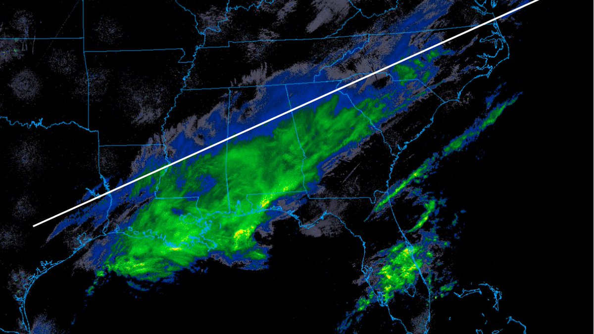
The sharpest snow accumulation gradient will be right along this line. Boom or doom for the CLT metro...
Gerald Mengel tweet media
English
16
4
113
18.4K
Eric Webb
Eric Webb@webberweather·
@nick5875 The difference between an inch and 3-4” is modest here. Wouldn’t take much of a shift to go from 1” to 3-4” in Wake County
English
1
0
11
1.5K
Eric Webb
Eric Webb@webberweather·
This winter storm in the Carolinas is just like the good ‘ol days, when we really didn’t have a clue what was actually going to happen until the very last second. Historically speaking though, last second north trends like this with overrunning events are mostly undefeated. A lot of folks having to be reminded of this yet again. #ncwx #scwx
English
24
15
270
36.1K
astro
astro@astroV4L·
@TropicalSaiel Surely this extends cuz it’s looking like we will get some frontogenesis and the DGZ is looking better too
English
0
0
1
106
astro
astro@astroV4L·
@GMengel Hopefully that frontogenesis from the NAM stays in place and we get this extended through the triangle 🫡
English
0
0
2
226
Gerald Mengel
Gerald Mengel@GMengel·
Map of the day: We are already seeing snow accumulate in the Augusta area. The reason is frontogenesis at 700mb. Lift combined with a saturated DGZ is getting it done early this afternoon. This favorable area will move into the midlands soon.
Gerald Mengel tweet media
English
7
4
43
6.2K
astro
astro@astroV4L·
@WXTriad I don’t fully remember. Was in Greenville at the time. Looking back to my old pics we definitely got 6-7” in my neighborhood it was really nice
English
0
0
0
37
astro
astro@astroV4L·
@WXTriad I mean idk I’m just regurgitating what I read online. I was 12 when that happened
English
1
0
0
74
astro
astro@astroV4L·
@WXTriad Really, I thought 1/28 was cooked 4 days out but 2-3 days out it came back. I’m in Raleigh
English
2
0
0
90
wxsammy
wxsammy@wx_sammy·
@astroV4L We’ll see. If ur in the heart of the triad (Greensboro) still thinking we see 1” at best , maybe 1.5 if we’re lucky
English
1
0
0
151
astro
astro@astroV4L·
@WXTriad Euro got fully cooked
English
1
0
0
71
wxsammy
wxsammy@wx_sammy·
@astroV4L I think things are just gonna keep flip flopping. Right now just watching EURO ENS & NBM as GFS/GEFS and some other ones don’t know what the f*ck to do
English
1
0
1
199
Tim Buckley
Tim Buckley@TimBuckleyWX·
Today was the day we really got rid of lingering snow and ice. Why? High dew points. Dew points above freezing cause the snow piles to condense water from the air around them, accelerating the melt.
English
3
5
57
6K
astro
astro@astroV4L·
@TropicalSaiel Is it looking better or worse for the triangle?
English
0
0
0
137
Saiel
Saiel@TropicalSaiel·
Can’t recall seeing this ever down here…. WSSI index extreme impacts chances getting to 20-30% in some areas of the SE. Not likely but highlights big impacts are very possible.
Saiel tweet media
English
1
6
38
4.3K
Mads
Mads@wrinkle__intime·
@astroV4L @JustinWx 2018 was a solid year too — but since then, oof
English
1
0
0
105