Beth Alderson

49 posts

Beth Alderson

Beth Alderson

@bethalderson

Raleigh, NC Katılım Haziran 2010
158 Takip Edilen78 Takipçiler
Beth Alderson
Beth Alderson@bethalderson·
@RadPowerBikes Please help. We have been trying to get in touch with customer service for a week now. We’ve tried email and waited all day for several days on the chat. Please respond. Thank you.
English
1
0
0
11
Allan Huffman
Allan Huffman@RaleighWx·
A sad day for me and my family. My mom went to be with the Lord last night after battling stage 4 cancer for a few weeks. The Lord is good and prayers for me and my family are appreciated. Thanks.
English
143
6
532
0
Allan Huffman
Allan Huffman@RaleighWx·
3) Check out my earlier post for in-depth analysis of the winter storm. In general, I think we see some snow by daybreak Sunday in RDU. With a gradual changeover to sleet/freezing rain and maybe rain by afternoon. Subject to change!
English
2
0
6
0
Allan Huffman
Allan Huffman@RaleighWx·
1) Local Weather summary. Calm before the storm. Dry the next 3 days with highs in the low 50s for RDU. I cant rule out a stray sprinkle Thursday night and a possible snow shower or two in the mountains.
English
1
0
11
0
Beth Alderson
Beth Alderson@bethalderson·
@RaleighWx hi! Do you tomorrow will be a big rain event? (Trying to decide if I need to reschedule luminaries again.)
English
1
0
0
0
Beth Alderson
Beth Alderson@bethalderson·
@RaleighWx I’m in charge of luminaries on Christmas Eve for my neighborhood in Raleigh . Do you think it will be ok or should we move to NYE?
English
1
0
0
0
Allan Huffman
Allan Huffman@RaleighWx·
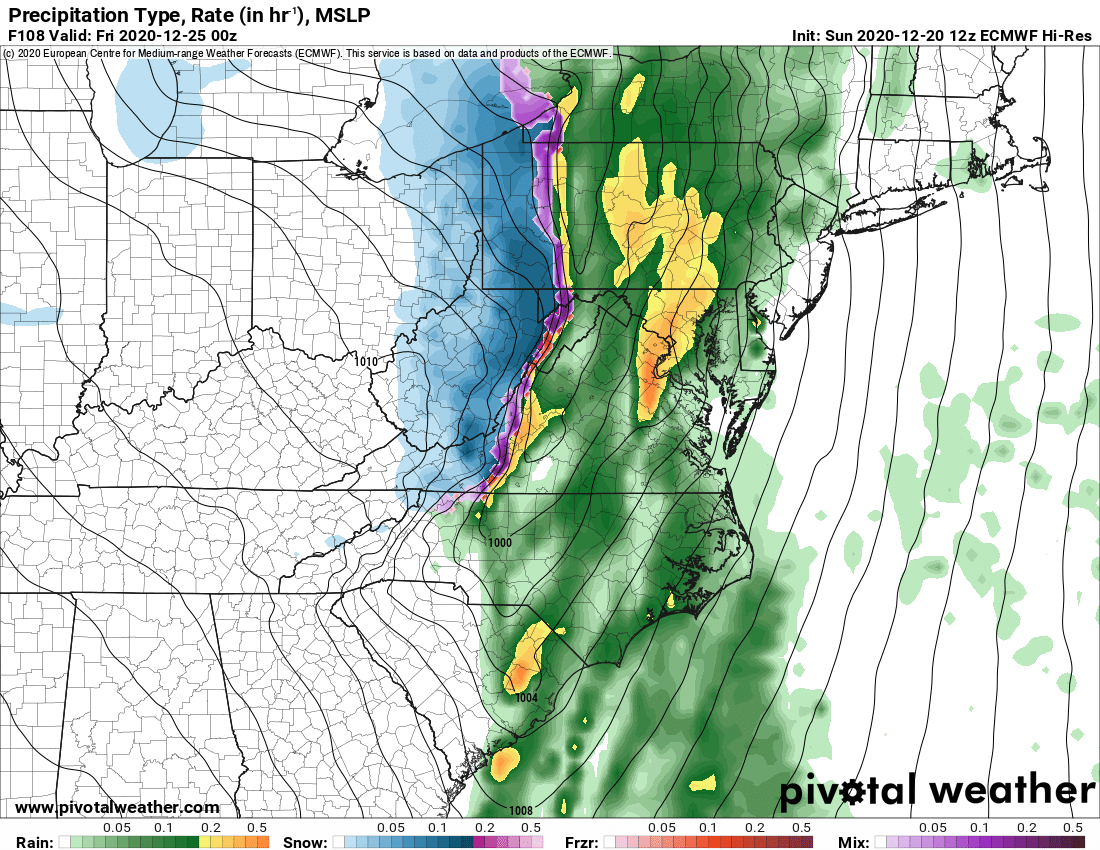
12z ECMWF shows the front moving through the NC piedmont Christmas Eve evening. Heavy rain. Gusts of 50+ mph possible. Wind gusts likely overdone. but gusts of 40-50 mph certainly possible
Allan Huffman tweet mediaAllan Huffman tweet media
English
9
6
35
0
Allan Huffman
Allan Huffman@RaleighWx·
The axis of heaviest rain shifted SE a bit across the Carolinas for the 12z ECMWF compared to the 6z ECMWF. #Sally Widespread swath of 3-7 inches of rain from N Ga to northern SC southern and eastern NC.
GIF
English
5
6
18
0
Beth Alderson
Beth Alderson@bethalderson·
@RaleighWx Do your anti storm dance for 9/17-9/20 please. I have a girls beach trip. 😬
English
1
0
0
0
Allan Huffman
Allan Huffman@RaleighWx·
My take on the tropics. I am not super worried about #Paulette or #Rene US threat wise. #Invest94L will move into the Carolinas Thursday night likely as nothing or a depression/perhaps minimal TS. I am more concerned with the wave about to emerge. But plenty of time to watch
English
3
2
46
0
Allan Huffman
Allan Huffman@RaleighWx·
@bethalderson I think it means we will for sure changeover to snow mid to late afternoon. Hope you dad is doing well.
English
1
0
1
0
Allan Huffman
Allan Huffman@RaleighWx·
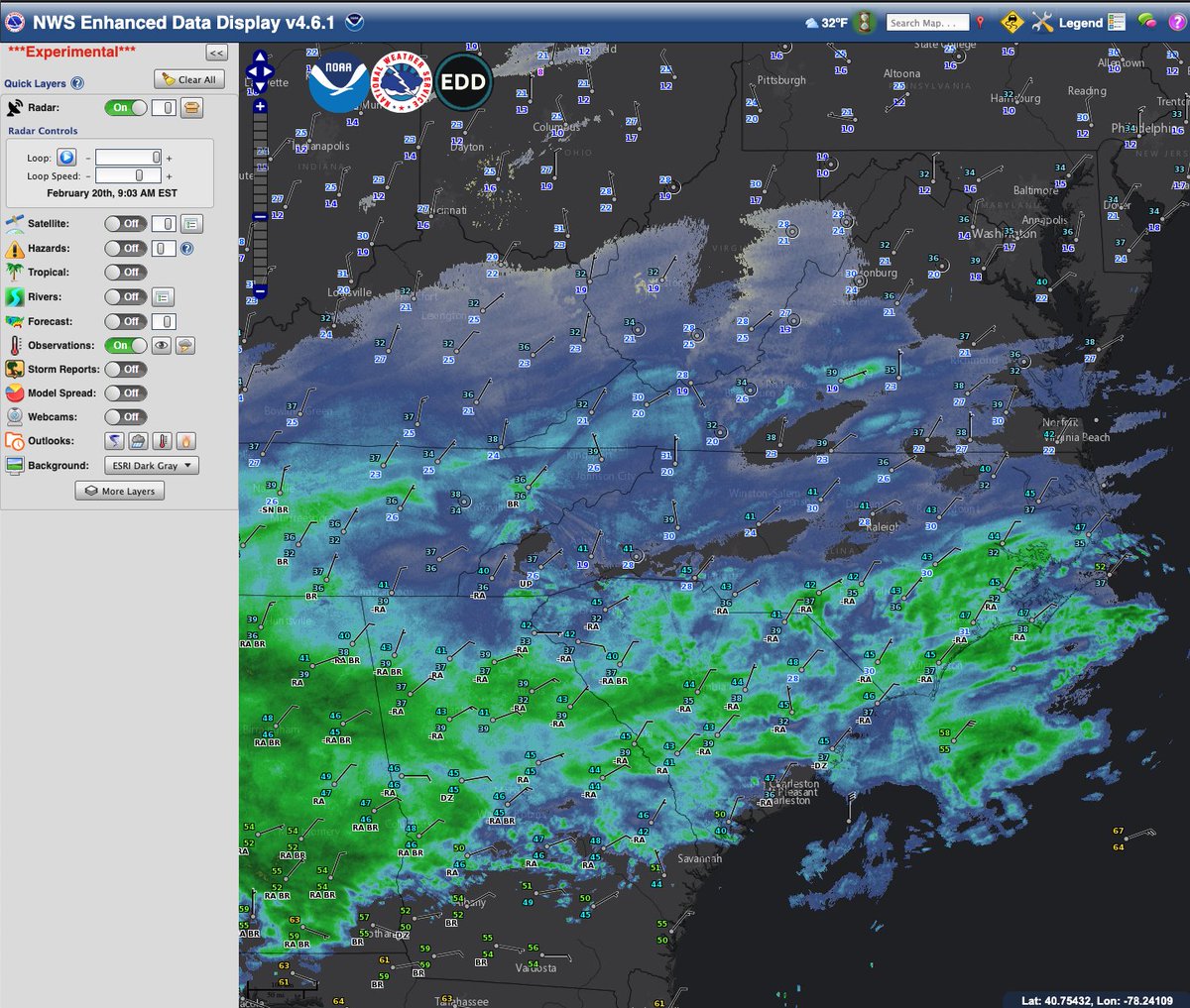
Snow is falling in the mountains and rain is mixing with sleet in the southern piedmont and sandhills. Also note below the NE winds advecting in lower dewpoints, Dewpoints have fallen into the 20s in the N piedmont. This will drive evaparational cooling when the precip begins.
Allan Huffman tweet media
English
7
4
29
0
Allan Huffman
Allan Huffman@RaleighWx·
30s for highs, Thursday as well. And lows Thursday could be in the upper teens. So winter isnt finished yet. I will keep you updated on the wintry potential.
English
3
0
20
0
Allan Huffman
Allan Huffman@RaleighWx·
So with regard to the wintry potential. I cant add alot more detail right now, as the models continue to oscillate around with each cycle and dont agree well with each other. Looks like two waves with this system. The 1st Sunday/Monday. As of now, it looks like this wave will
English
2
2
22
0
Allan Huffman
Allan Huffman@RaleighWx·
12z RGEM forecast accumulation by p-types. If true, would be quite a lot of sleet across western piedmont/NW piedmont, heavy snow mtns/foothills/northern tier, nasty freezing rain CLT to RDU corridor.
Allan Huffman tweet mediaAllan Huffman tweet mediaAllan Huffman tweet media
English
12
7
13
0
Beth Alderson retweetledi
Cookie Monster
Cookie Monster@MeCookieMonster·
Today canceled. Me staying in bed and eating cookies.
English
915
44.9K
153.8K
0
Allan Huffman
Allan Huffman@RaleighWx·
Alright here is my first call. Obviously subject to changes and tweaks. Certain areas are tricky and will likely require further refinement. Areas of SW NC/E TN are always tricky for me, so rely on local experts in those areas. Will try to answer any questions I can #ncwx #vawx
Allan Huffman tweet media
English
41
71
160
0
Allan Huffman
Allan Huffman@RaleighWx·
@bethalderson 20-30 inches of rain. Winds 75-100 mph. You are welcome, hope your dad is well.
English
1
0
1
0
Beth Alderson
Beth Alderson@bethalderson·
@RaleighWx what’s your prediction for Ocean Isle Beach? Wind, rain, etc? Thank you for working so hard.
English
1
0
0
0
Beth Alderson retweetledi
Governor Josh Stein
Governor Josh Stein@NC_Governor·
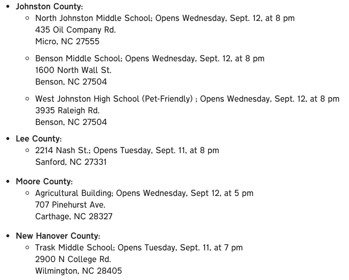
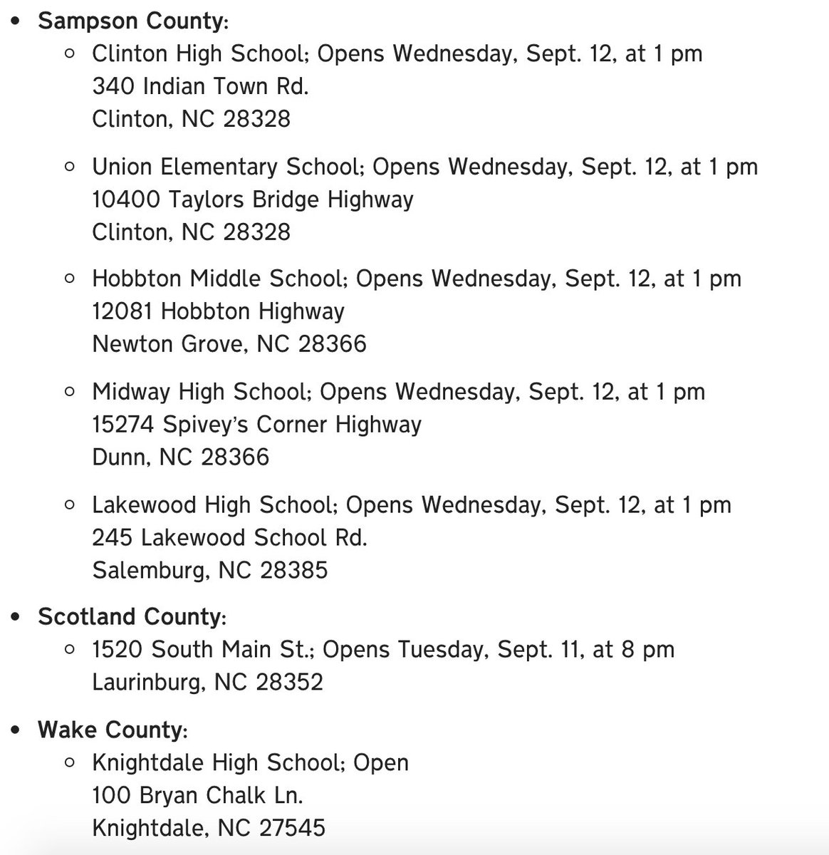
RETWEET THIS: Here is a list of shelters opening to take in people displaced by evacuations:
Governor Josh Stein tweet mediaGovernor Josh Stein tweet mediaGovernor Josh Stein tweet media
English
46
4.2K
1.9K
0
Zac Brown Band
Zac Brown Band@zacbrownband·
Please see below statement regarding this week’s shows. We are urging everyone to stay safe and our thoughts are with all of you during this difficult time!
Zac Brown Band tweet mediaZac Brown Band tweet media
English
39
52
264
0
Allan Huffman
Allan Huffman@RaleighWx·
@Elkerster @Cartersfan2 I would like to see another full cycle (00z) suite come in showing the same scenario. If it does tomorrow morning, we could see major changes to the forecast.
English
1
0
7
0
Allan Huffman
Allan Huffman@RaleighWx·
The 18z GFS is following the 12z ECMWF idea a stall east of Cape Fear and a movement SSW parallel to the SC coast. #Florence
English
5
14
15
0
Allan Huffman
Allan Huffman@RaleighWx·
(5) The end of my initial morning thoughts. Will be posting all day of course with latest trends etc.
English
7
2
16
0