Sabitlenmiş Tweet
Tombo
26.7K posts


Tombo
@cbhstiger
I mostly tweet about ➡️ | 🐯 @Memphis_MBB @MemphisFB | @Memgrizz | ⚽ @Memphis901FC | 🇺🇸 @USMNT | 🏴 @ChelseaFC | Video games, TV, & random ish
Memphis, TN Katılım Temmuz 2009
405 Takip Edilen618 Takipçiler

Tombo retweetledi

English
Tombo retweetledi

US 🇺🇸 Soccer can’t even do a proper World Cup jersey announcement…
Oh well, at least they look good.
USMNT Only@usmntonly
Diego Luna in the new USMNT kit set to be released tomorrow 👀🇺🇸
English
Most unserious season ive ever witnessed
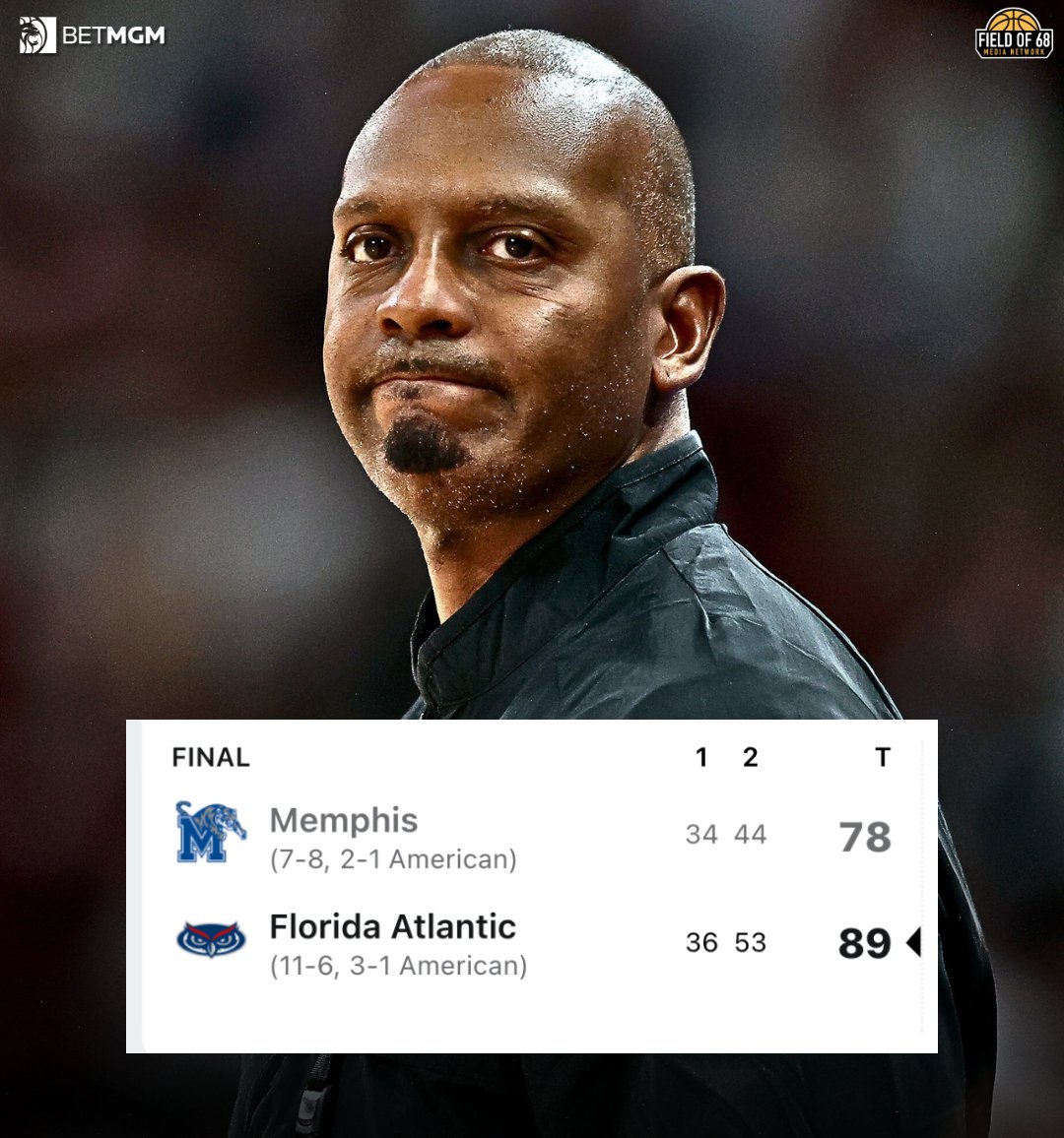
Jason Munz@munzly
That’ll do it for the 2025-26 Tigers
English
Haven't watched a game in months. First time not watching since I was 7. Such a bad feeling but this NIL era has kinda killed my love for college sports for now.
Memphis Basketball@Memphis_MBB
Final from Greenville: ECU 84, Memphis 68
English

I play most things at over 120fps these days so 30 is absolutely a dealbreaker
JaePlayzGamez@JaeGamez
Do you notice the difference between 30fps & 60fps?? 60 fps does look smoother, don’t get me wrong, but I don’t understand people that that say 30fps is a dealbreaker.
English
RT @BobbyMarks42: Memphis now has 13 firsts in the next 7 years.
They are tied with Brooklyn and OKC.
English
Tombo retweetledi

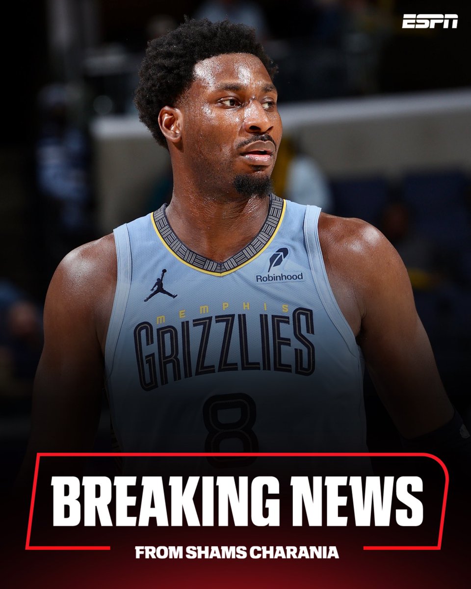
BREAKING: The Memphis Grizzlies are trading star forward Jaren Jackson Jr., John Konchar, Jock Landale and Vince Williams Jr. to the Utah Jazz for Walter Clayton Jr., Kyle Anderson, Taylor Hendricks, Georges Niang and three future first-round picks, sources tell ESPN.
English
Tombo retweetledi

They literally disarmed him first and then shot him
English
Got my cutwater ready 😅😅
MemphisWeather.net@memphisweather1
The NWS has issued Winter Storm Warnings. Here's how to interpret them.
English
Fuuuuuuuuuuukkk
MemphisWeather.net@memphisweather1
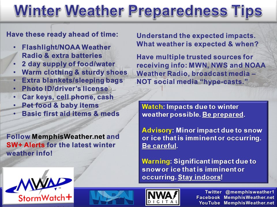
* 1:00pm Wednesday -- Winter Storm Watch Issued * (long post) The focus today and tomorrow should be on PREPARATION for a significant winter storm, likely producing all types of winter precipitation within the metro. Since yesterday, the area forecast to see some warm air aloft (which results in more freezing rain/sleet and less snow) has shifted north. It now includes the heart of the metro, which throws a monkey wrench in the forecast. Graphics below, courtesy NWS-Memphis, tell the story. A Winter Storm Watch starts Friday at noon and expires at 6pm Sunday. Per the latest model guidance, very light precip could start as early as mid-afternoon Friday, but accumulating precip is likely to hold off until late evening Friday. Saturday will be a real mess and Sunday should see light precip taper off by midday. You'll notice on the graphics that the area of most uncertainty with respect to precip types and amounts now includes the metro. The probability graphics indicate that 3-6" of snow and sleet and 1/4" to maybe 1/2" of freezing rain (ice) are possible to likely. If the northward trend in the warm air aloft continues, ice amounts will increase and the snow will decrease. We don't want this! One-quarter of an inch of ice could start bringing down tree limbs and power lines. We expect more changes to this as we get closer - it's still more than 48 hours until onset of any precipitation. Use this info to PLAN, not as gospel! During and behind this system, temperatures will be #StupidCold. We could stay below freezing for over 100 hours (until Wednesday PM) and temperatures may approach ZERO Monday and Tuesday mornings. Recovery will be slow and melting will take several days despite sunshine early next week. Plan to avoid travel from after dusk Friday through the weekend, and likely into early next week. Some power outages seem likely and could take time to restore.
Tombo retweetledi
5:00pm Tuesday -- January Winter Storm Update
The Mid-South remains on track for a potentially significant winter storm this weekend. While fine-scale details are still TBD, we are starting to see some trends materialize. Our main message right now is PREPARATION. (You have our permission to buy "milk sammich" ingredients.)
Here's what we know:
* The storm will be impactful. There is a high likelihood of "moderate impacts", including disruptions to commerce and infrastructure (i.e., power) and hazardous to dangerous travel conditions. The threat of major impacts is increasing as well. Just plan to stay off the roads this weekend unless absolutely necessary.
* The precipitation will be prolonged, likely beginning by Friday evening and continuing through at least Sunday morning. Saturday daytime/evening hours appear to be the most persistent/heaviest.
* Significant snow/ice totals are expected. Freezing rain and sleet chances appear to increase quickly south of the I-40 corridor, mainly in north MS. Straight snow is most likely north of I-40. (There's nothing magical about I-40. It's a line most people know. I could have said Highway 70 too.)
* #StupidCold conditions will accompany the storm and continue into the first half of next week. We're talking 4+ days below freezing with coldest low temps early next week - in the single digits. Yep, pipe-bursting cold.
* This storm has "top 5" potential for Memphis winter snowfall. Last January, 7.5" fell, putting it in the top 10. The chance of consecutive years with that amount is very small. But never say never...
Here's what is not known:
* Exactly WHAT precip types will occur and HOW MUCH snow/sleet/freezing rain will fall. Especially at your house. See above - increasing chances of ice as you move south into north MS.
* Exactly when it will start/stop or when precip changes will take place.
* When it will all go away. (But think back to last January's 6-8" snow. It took several days for the snow to melt. And we were above freezing every day after the storm. Not this time.)
This is not a system that will end up being "just a cold rain." Use the next couple of days to prepare. We'll refine the forecast and keep you posted as details emerge that we have some confidence in. Stay safe & warm!

English
Tombo retweetledi

Memphis falls back below .500 😬
It's their worst 15 game start to a season since 2000-01 🤯
English
Tombo retweetledi

Memphis has not been under .500 this deep into a season since 2000-01 (when the Tigers were 4-8 -- Calipari's first season as coach)
English