DroneDash

151 posts

DroneDash banner
DroneDash

DroneDash

@drone_dash

Aerial Robotics, Precision Sensing - Turning Asia's Plantation Operations into Real-time Crop Intelligence.

Singapore Katılım Mayıs 2024
1.5K Takip Edilen744 Takipçiler
DroneDash retweetledi
Alex- defi
Alex- defi@Alexflexdefi·
What happens when you combine drones, AI, and blockchain to solve one of the world’s oldest challenges feeding a growing population without destroying the planet? In Malaysia, Farmsent is leading a groundbreaking transformation of over 490,000 acres of palm plantations through a real-world, scalable blueprint for sustainable agriculture. This initiative is powered by a strategic collaboration with DroneDash and SkyX. @yogtalks Co-founder, @Farmsent_io “We’re not just optimizing yields – we’re building a more resilient and equitable food system.” Farmsent’s Vision: Smarter, Transparent, and Sustainable Farming at Scale Farmsent’s innovative approach leverages autonomous drones, AI, and blockchain to revolutionize farming practices. By integrating these technologies, Farmsent empowers farmers with precision, transparency, and efficiency. 
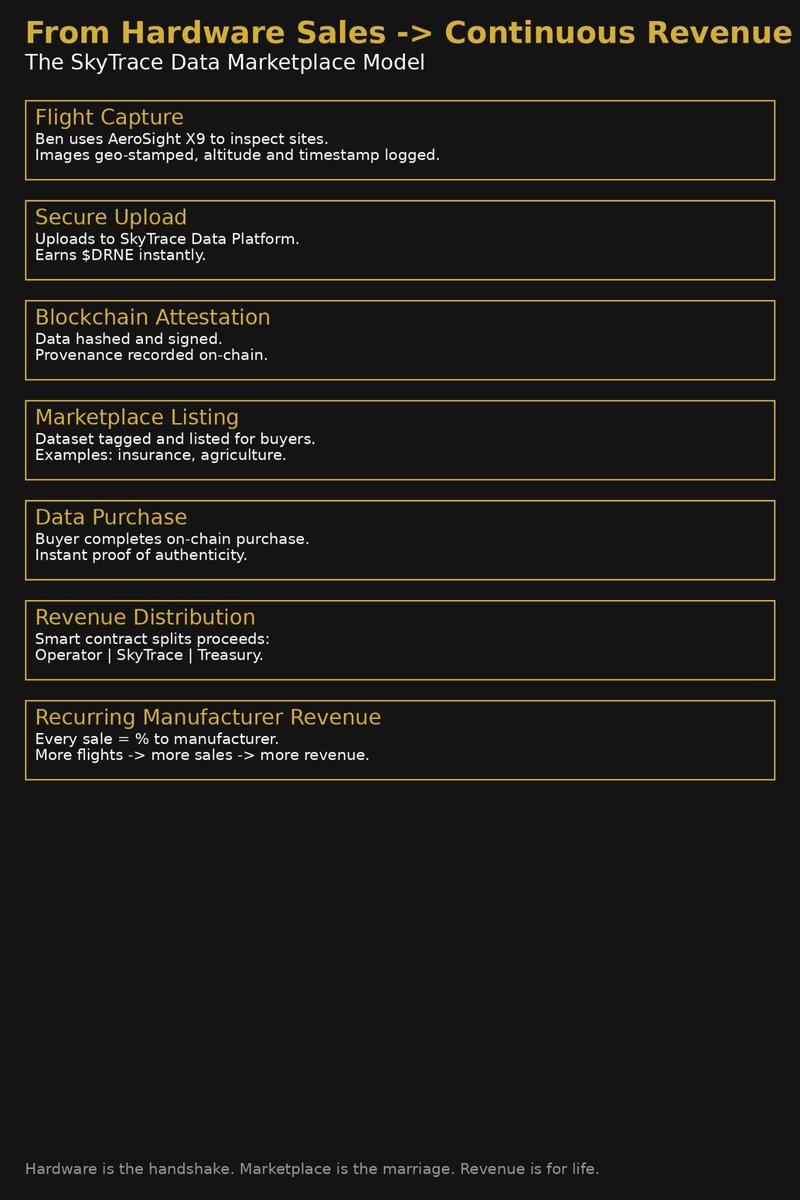
The Role of DroneDash: Precision and Efficiency in the Field @drone_dash provides the autonomous drone technology that is central to Farmsent’s strategy. Their drones apply fertilizers and pesticides with surgical precision reducing chemical use by up to 50%, cutting operational costs, and minimizing environmental impact. This precision farming not only boosts productivity but also safeguards surrounding ecosystems. @SkyX_Network complements the system by deploying hyper-precise weather stations across the plantations. These stations monitor microclimates, capturing humidity, wind, rainfall, and other critical data, which feeds into Farmsent’s AI-driven decision-making platform. Blockchain-Enabled Transparency and Investment Through the @peaq blockchain, every drone, sensor, and weather station is assigned a unique digital identity. This allows: Transparent tracking of agricultural inputs and outputs Real-time performance monitoring of devices Tokenization of assets, inviting global investors to support sustainable farming infrastructure Why This Matters With more than 40% of global agriculture relying on unsustainable groundwater and climate risks escalating, Farmsent’s model offers a sustainable path forward. The UN forecasts a 70% increase in food demand by 2050, making innovation essential. By combining Farmsent’s vision with DroneDash’s precision drones and SkyX’s microclimate data, this initiative: Boosts yields sustainably Cuts costs and chemical usage Reduces environmental harm Creates new investment opportunities via Web3 Builds a resilient, equitable food system A Blueprint for the Future
Alex- defi tweet media
English
12
2
22
727
DroneDash retweetledi
GEODNET
GEODNET@GEODNET·
🌾 September = Harvest. ⚡ Harvest needs precision. Whether it’s fields, factories, or data— only accuracy brings real yield. This season: cut the noise, dial in the precision, and reap the results.
GEODNET tweet media
English
1
9
54
2K
DroneDash retweetledi
GEODNET
GEODNET@GEODNET·
Don’t miss it — set your alarm ⏰ it’s a sneak peek into the massive progress we’ve been cooking behind the scenes. 🔥 @drone_dash
GEODNET tweet media
English
2
6
41
2.5K
DroneDash
DroneDash@drone_dash·
Do join us on 25th August 8am PST where Mike and I will be discussing more on Precision Agriculture and the opportunities in Asia and how DePin is a key strategy
DroneDash tweet media
English
1
0
3
2.1K
DroneDash retweetledi
GEODNET
GEODNET@GEODNET·
SmartFarming Era. - Increased Yields and Efficiency - Cost Savings - Environmental Sustainability - Data-Driven Decision Making - Global Food Security Built to feed the world while protecting the planet.
GEODNET tweet media
English
1
7
56
1.4K
DroneDash retweetledi
GEODNET
GEODNET@GEODNET·
@drone_dash Sorry guys we have to reschedule the AMA due to technical difficulties. Will keep all posted🫶
English
1
1
10
665
DroneDash
DroneDash@drone_dash·
@geodnet Looking forward to our upcoming AMA where we will discuss more in detail how and why our two companies are collaborating !
English
0
0
2
40
DroneDash retweetledi
GEODNET
GEODNET@GEODNET·
@drone_dash DroneDash is Southeast Asia’s leading ag-robotics platform, helping farmers automate up to 70% of operations with drones, rovers, and AI sensors—boosting yield, cutting costs, and requiring zero upfront investment.
GEODNET tweet media
English
4
3
9
775
DroneDash retweetledi
GEODNET
GEODNET@GEODNET·
🚨 AMA Incoming! @geodnet x @drone_dash Join us as we dive into the future of precision RTK + drone delivery — and how decentralized infrastructure is shaping aerial logistics. Date: August 21st 8am PST Live on X Space: x.com/i/spaces/1ZkJz…📍
GEODNET tweet media
English
7
3
25
3.1K
DroneDash
DroneDash@drone_dash·
@panroboticsxyz I really like this! I believe theres synergy with what DroneDash is doing.
English
0
0
1
18
Pan Robotics
Pan Robotics@panroboticsxyz·
Imagine... Ben, a drone pilot in Bristol, UK, likes to think of himself as part pilot, part photographer, part… floating CCTV camera. Today, his trusty AeroSight X9 from SkyTrace Robotics is clocking overtime, buzzing over cranes, scaffolding, and steel beams like a wasp with a camera fetish. Every image is geo-stamped, altitude-logged, and timestamped, because if you can’t prove exactly when you took that photo, did it even happen? Back at his home office (read: kitchen table with suspicious coffee stains), Ben logs into the SkyTrace Data Platform. He uploads today’s haul, selects the Structural Inspection category, and watches the platform wrap each file in enough metadata to make an NSA analyst blush. The reward? 1,420 $DRNE tokens, a cool $69 USD, because nothing says “hard day’s work” like getting paid in crypto for pictures of rusty girders. Meanwhile, in the background, SkyTrace’s blockchain-based attestation engine is doing the digital equivalent of notarising everything. Each image gets hashed, signed, and immortalised on-chain, tying it forever to Ben’s operator ID and his AeroSight X9. His personal details remain private, because while the blockchain loves transparency, it also knows not to give your phone number to strangers. Fast forward a few days and Ben’s dataset is listed on SkyTrace’s private B2B marketplace and public data exchange. The tags read like a dinner party icebreaker: Bristol, Aug 2025, Structural Inspection, Post-Storm Conditions. An insurance company in Manchester pounces, they need post-storm aerial photos to speed up claims processing, and Ben’s are basically the caviar of roof damage imagery. The purchase hits SkyTrace’s smart contract system, which slices the revenue like a polite blockchain sushi chef: a share for Ben, a cut for SkyTrace, and a nibble for the network treasury. Hours later, 380 more $DRNE tokens quietly arrive in Ben’s wallet, proof that somewhere, his photos of bent scaffolding are making someone’s job a lot easier. Ben is one of 5,000+ operators in 42 countries, capturing everything from urban skylines to agricultural fields to post-apocalyptic storm scenes. In this world, every byte is verifiable, traceable, and rewarded. From flight → blockchain → marketplace → wallet, it’s the decentralised data economy. part gig work, part tech magic, part “can you believe people pay me for this?”... ... You could be SkyTrace
Pan Robotics tweet media
English
1
1
3
154
DroneDash
DroneDash@drone_dash·
This isn’t just tech hype — it’s field-ready, backed by research, and scalable across millions of hectares. The first movers in this space will define the future of precision agriculture in Asia.
English
1
0
2
168
DroneDash
DroneDash@drone_dash·
✅ Water savings: up to 30% ✅ Fertiliser reduction: up to 25–50% ✅ Yield boost: 10–25% ✅ Lower losses from early stress detection
English
0
0
3
205
DroneDash
DroneDash@drone_dash·
📊 Our model: 1 full-stack soil sensor set = 1 per hectare 1 weather station = per 100 ha Palm area: 🇲🇾 5.3M ha | 🇮🇩 16.5M ha 💰 Addressable market: $6.54 BILLION / year
English
0
0
3
193
DroneDash
DroneDash@drone_dash·
DroneDash’s integrated sensor system combines: 📍 Soil pH 💧 Moisture 🌡️ Temperature ⚡ Bulk EC & Pore EC 🌦️ Hyperlocal Weather All feeding into predictive models for irrigation, fertilisation & disease prevention.
English
1
0
3
137