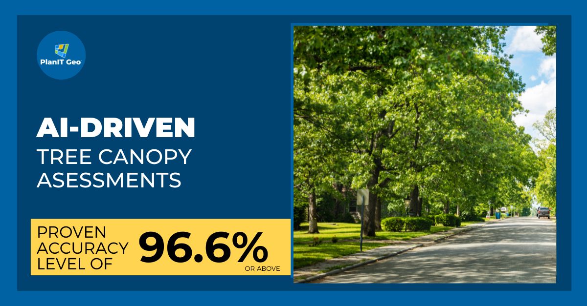
EarthDefine

432 posts

EarthDefine banner
EarthDefine

EarthDefine

@earthdefineLLC

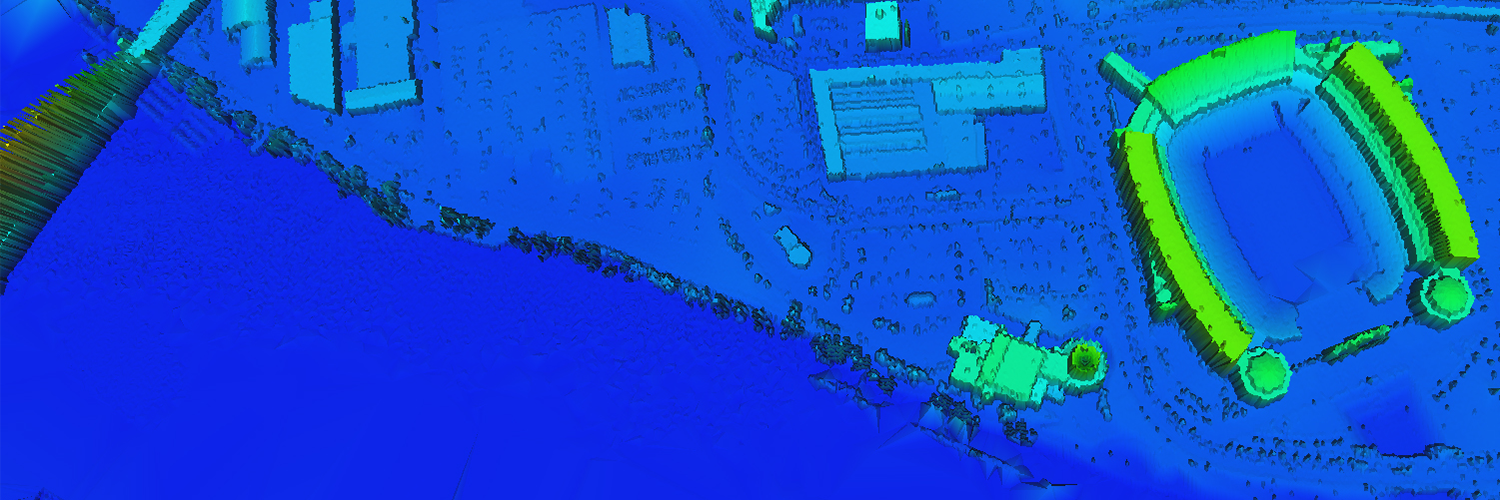
Scaling AI for Mapping

Redmond, WA Katılım Mart 2014
184 Takip Edilen258 Takipçiler
EarthDefine retweetledi
CAL FIRE
CAL FIRE@CAL_FIRE·
CAL FIRE, in partnership with the USDA Forest Service, has launched a powerful new interactive mapping tool to visualize California’s urban tree canopy and track changes between 2018 and 2022. This user-friendly platform provides high-resolution data for all urban areas across the state and overlays important info like census data, heat severity, and wildfire risk to help communities plan, plant, and protect trees more effectively. Whether you're a policymaker, local leader, or community member, this tool supports smarter decisions for healthier, greener neighborhoods. Explore the tool now and register for our public webinar on April 29 at 10 AM to learn more! 🌿 Webinar Registration: bit.ly/3RIGxo1 Urban Canopy Viewer: bit.ly/UrbanCanopyVie… #UrbanForestry #CALFIRE #TreeCanopy #ClimateAction #GreenerCA
English
0
10
24
7.1K
EarthDefine retweetledi
PlanIT Geo
PlanIT Geo@PlanItGeo2012·
RECEIVE AN IRA AWARD LETTER in September? Are you poised to take advantage of incoming funding opportunities from states and regranting organizations? Now is the time to prepare so that shovels can hit the dirt as soon as money hits the bank account. bit.ly/3CA8GFa
PlanIT Geo tweet media
English
0
2
2
175
EarthDefine
EarthDefine@earthdefineLLC·
The Effects of Flood Buyouts and Green Infrastructure on Nearby Property Values shar.es/agm8o Interesting research on how tree canopy coverage could potentially mitigate the negative effect of buyout activities on property values
English
0
0
0
71
EarthDefine retweetledi
Pew Environment
Pew Environment@pewenvironment·
Fact: Less than 1% of U.S. rivers are federally protected. These essential ecosystems provide clean drinking water, wildlife habitat, and recreational opportunities. It’s clear to see why so many are working to protect them. pew.org/40lEOYs
English
0
5
9
1.6K
EarthDefine retweetledi
PlanIT Geo
PlanIT Geo@PlanItGeo2012·
Artificial intelligence has been a hot topic recently. Through a partnership with EarthDefine, we use AI-Driven canopy data to provide accurate, fast, and accessible tree canopy assessments. Check out our webinar to see a full breakdown of the process. - bit.ly/3DcRJlJ
PlanIT Geo tweet media
English
0
1
2
164
EarthDefine retweetledi
Massimo
Massimo@Rainmaker1973·
The movement of the tectonic plates along the fault captured by satellites at Nurdağı, Turkey, following the 6-7 February earthquakes. The relative shift is around 3-4 meters [📷Andreas Schafer, Maxar Technologies]
English
147
4.8K
20.2K
3.4M