Storms themselves continue to lift north which is great (although still watching those closely).
Either way, these storms will send straight line winds into Davidson Co which may be 40 MPH or more. This is good news for now, more to follow later today / 932 AM
There are VERY strong winds with storms around Clarksville, heading toward Springfield. No areas of rotation right now, but a tornado could develop quickly. Stay close to a secure shelter if you’re in this area.
@hvillewx@Spirit29@NWSNashville We are about to hit another quiet patch with the main event happening sometime around 10-12 give or take. They also said it will happen on patches around the counties. Don’t count it out just yet and make sure you can wake up fast if something happens
4:32 PM Radar Update: Severe thunderstorms across western Middle TN continue to make their way eastward. Large hail, damaging winds, and tornadoes continue to be possible with these storms. Continue to stay weather-aware!
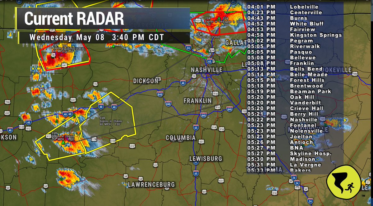
Supercell with large hail and damaging straight line winds accelerating to 45 MPH and pushing ETAs sooner than previously calculated. 5-6 PM the concern for this storm arriving in a very volatile atmosphere / 341 PM / Other ETAs attached
@Stephvoartist@NWSNashville It happens every year. Tornado and severe weather runs from March - May and then also the rest of the year when it feels like it. Weather just weathers in Tennessee with no rhyme or reason
@NWSNashville Are these kind is storms unusual here? We haven’t lived here long to know if this is a heightened event or normal this time of year? Trying to put things in perspective ! Thank you for all you guys do!
Along with the severe weather threat we could also see some flash flooding. Multiple rounds of thunderstorms later this evening into Thursday morning will bring heavy rain which could lead to some flooding along with rises on area rivers, creeks, and streams. #TNwx
Still feels like this event is like is your favorite metal band setting up to play -- but they may not have their bass player.
Or like you're ready for JayZ or AC/DC but instead you get Meghan Trainor. No shade on MT but just not the same.
Watching. Waiting. / 338 PM
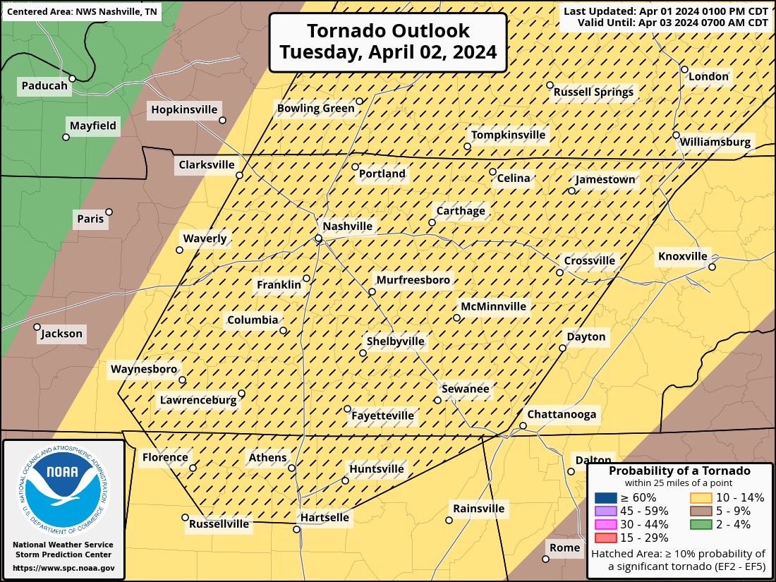
@NashSevereWx What do the slashes in the box mean? Some areas outside don’t have it and I’m not sure if it means more likely in the box and less likely outside it?
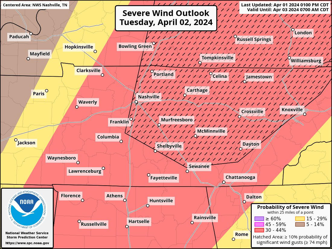
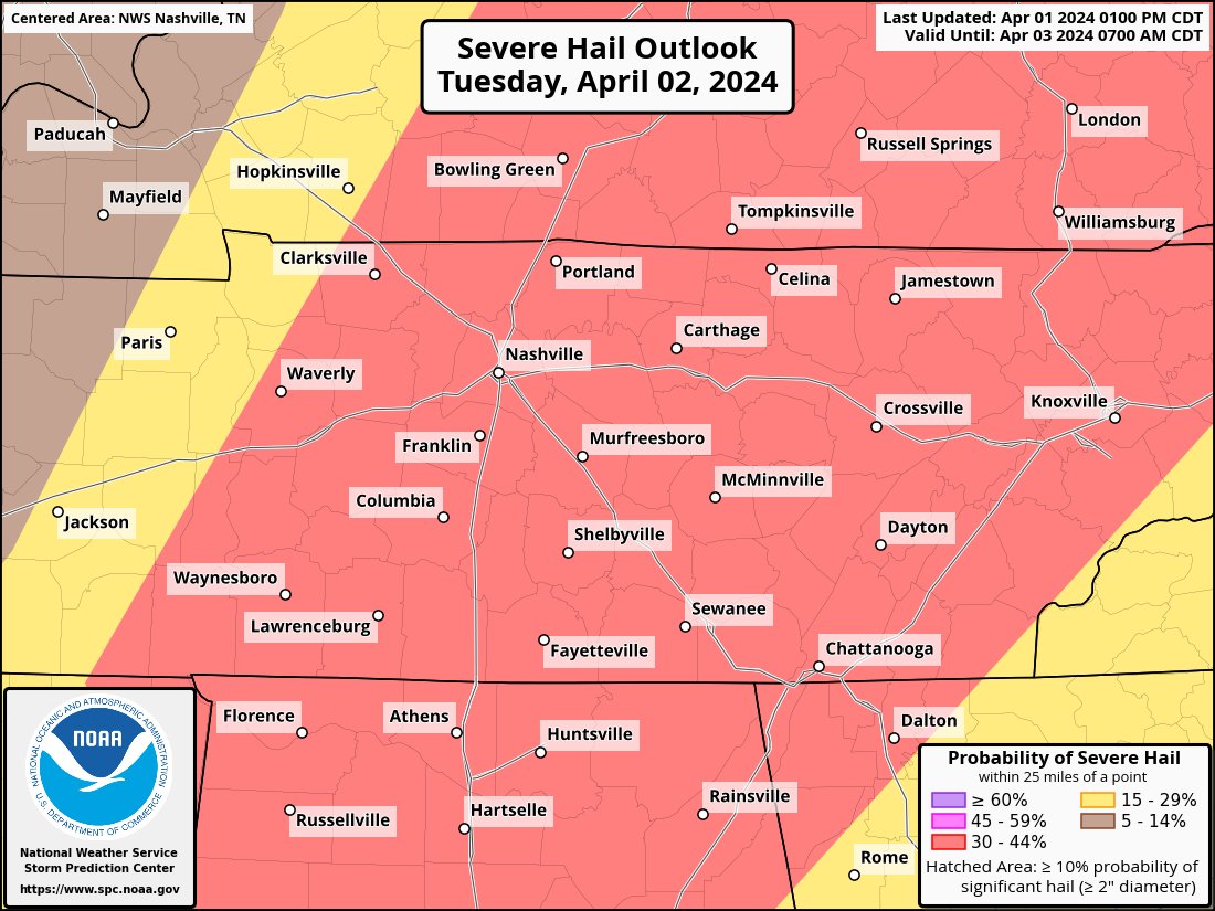
NEW: Storm Prediction Center upgrades our severe weather chances for tomorrow. Probabilities of "x" within 25 miles of you are now: Tornado 10% (those tornadoes could be strong), Damaging Wind - 30% (could exceed hurricane force), Large Hail - 30%. NO thanks.
Within 25 miles of you tomorrow, the chances of “x” occurring are: tornado – 10%, damaging winds – 30%, large hail – 15%. More info througho buff.ly/3SnvSyM
@NashSevereWx 😭🫰 let’s hope it’s just a nice, but loud wash. I always sleep better during thunderstorms. Thanks yall. Hope yall got coffee brewing. You’re in for a long night
Looks now like we'll have two rounds of storms. These storms....and the main line later overnight. These storms in SW Mid-TN should be here in the next couple of hours. Could be hailers. They also could steal some energy from round 2 overnight. But dunno yet. Radar 8:02 pm
7:10 pm - the storms to our SW are not the main event, nor do we expect them to strengthen. New balloon data shows a "cap" about 12,000 ft up that should put a lid on these things and cause them to weaken as they get closer. For the main event overnight, main risk remains damaging straight line winds. Appears the storms will have some energy to feed off of when they get here.