Spot-On-Weather LLC

10K posts

Spot-On-Weather LLC banner
Spot-On-Weather LLC

Spot-On-Weather LLC

@eulermatthew4

Website: https://t.co/3OkLrt7VcL Search Spot On Weather on YouTube for latest videos. Email: [email protected]

Spot On Weather Katılım Kasım 2016
67 Takip Edilen2.1K Takipçiler
Spot-On-Weather LLC
Spot-On-Weather LLC@eulermatthew4·
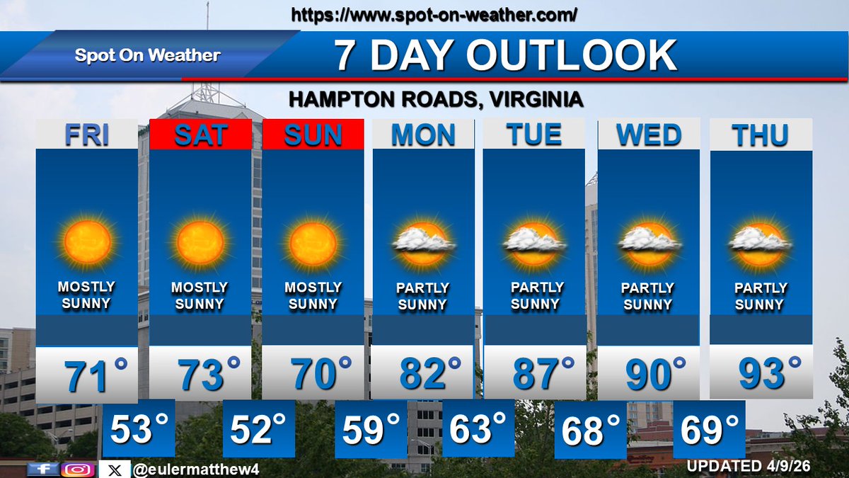
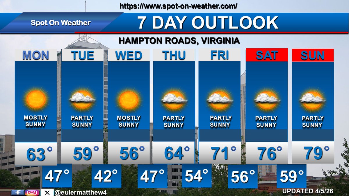
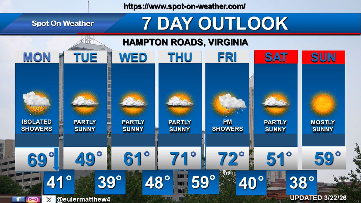
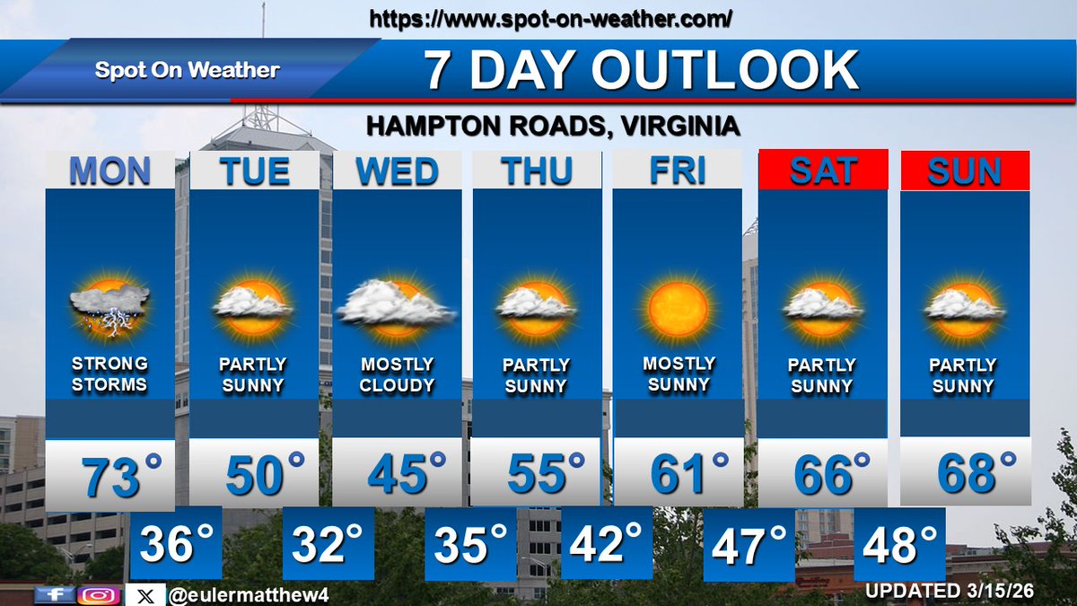
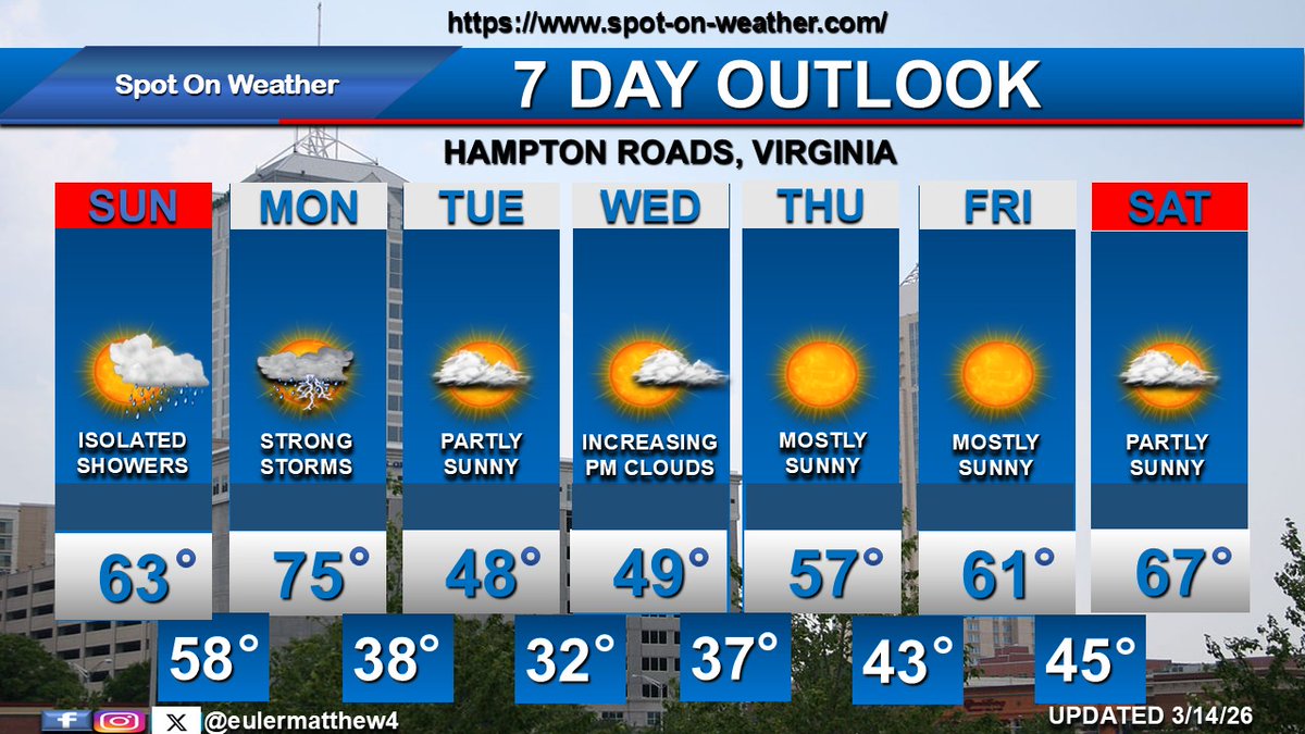
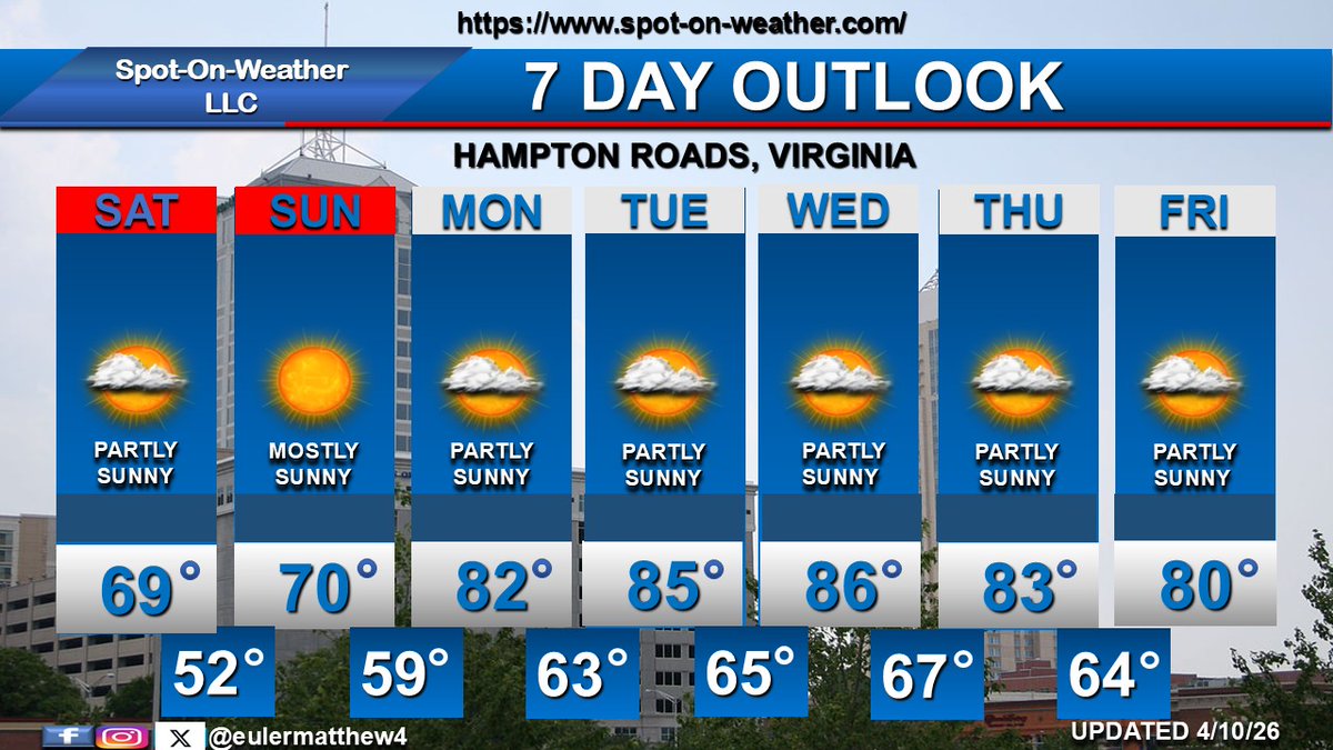
A cold front drops through the area on SAT with cooler, onshore winds for SAT and SUN. Much warmer beginning on MON and lasting through THU before a slight cool down on FRI. Still no rain in the forecast.
Spot-On-Weather LLC tweet media
English
0
0
0
54
Spot-On-Weather LLC
Spot-On-Weather LLC@eulermatthew4·
Plenty of sunshine for the weekend. A cold front drops into the area SAT keeping temperatures pleasant through SUN. Much warmer next MON through next THU as high temps climb into the lower 90s.
Spot-On-Weather LLC tweet media
English
0
0
0
97
Spot-On-Weather LLC
Spot-On-Weather LLC@eulermatthew4·
Review of Winter 2025-26. Winter started with a bang as Hampton Roads received a rare accumulating snow on the evening of December 8th, 2025. There is something magical when you combine snow and Christmas lights. @NWSWakefieldVA @wxmanricky
Spot-On-Weather LLC tweet mediaSpot-On-Weather LLC tweet mediaSpot-On-Weather LLC tweet mediaSpot-On-Weather LLC tweet media
English
0
0
2
137
Judah Cohen
Judah Cohen@judah47·
This is impressive. First our AI downward influence model predicted Greenland blocking (GB). Then our subseasonal AI model predicted GB week ending 19 April, 4 weeks (shared on X) & 3 weeks (in blog) in advance. 5 April GFS still showed no GB & today all models are predicting GB!
Judah Cohen tweet mediaJudah Cohen tweet mediaJudah Cohen tweet mediaJudah Cohen tweet media
English
14
8
113
9.4K
Spot-On-Weather LLC
Spot-On-Weather LLC@eulermatthew4·
Dry and cooler MON through WED as high pressure builds into the area from the north-northwest. High temps will be in the lower 60s dropping into the upper 50s. Slightly warmer THU before a bigger warm up into the 70s FRI through SUN.
Spot-On-Weather LLC tweet media
English
0
0
1
179
Mitch West
Mitch West@SCweather_wx·
It’s March 27th & I am already having occasional thoughts of September 1st..
English
14
0
86
6.7K
Spot-On-Weather LLC
Spot-On-Weather LLC@eulermatthew4·
VA Beach Annual Water Year Summaries (Total and Departure) 2023/24: 57.53" (+7.99") 2024/25: 47.87" (-1.37") @NWSWakefieldVA
English
0
0
1
167
Spot-On-Weather LLC
Spot-On-Weather LLC@eulermatthew4·
VA Beach Annual Water Year Summaries (Total and Departure) 2015/16: 77.85" (+28.31") 2016/17: 62.52" (+12.98") 2017/18: 50.40" (+0.86") 2018/19: 54.47" (+4.93") 2019/20: 60.48" (+10.94") 2020/21: 57.17" (+7.63") 2021/22: 42.37" (-7.17") 2022/23: 52.59" (+3.05") @NWSWakefieldVA
English
0
0
1
214
Spot-On-Weather LLC
Spot-On-Weather LLC@eulermatthew4·
High pressure moves offshore by Sunday evening. Milder air moves in MON through WED with high temps climbing into the 70s to near 80 degrees. More unsettled late WED through the end of the week with showers. For this forecast and much more, go to spot-on-weather.com
Spot-On-Weather LLC tweet media
English
0
0
1
128
Spot-On-Weather LLC
Spot-On-Weather LLC@eulermatthew4·
Wispy cirrus clouds over Chesapeake, Virginia
Spot-On-Weather LLC tweet media
English
0
0
1
135
Spot-On-Weather LLC
Spot-On-Weather LLC@eulermatthew4·
Isolated showers MON as a cold front drops through SE VA. Mild early with falling temps. Dry and colder TUE as high pressure builds in. Milder WED and THU with high pressure shifting offshore and return of southerly winds. Next cold front drops through on FRI with showers.
Spot-On-Weather LLC tweet media
English
0
0
1
133
Spot-On-Weather LLC
Spot-On-Weather LLC@eulermatthew4·
For the latest weather forecasts across Hampton Roads, Virginia, go to the below website, then click the 7-day weather forecast tab at the top. spot-on-weather.com
English
0
0
1
190
Spot-On-Weather LLC
Spot-On-Weather LLC@eulermatthew4·
Strong thunderstorms are likely on MON with heavy rain showers, damaging winds, and potential tornadoes as a strong cold front moves across the area. Dry and colder for TUE and WED. Dry and chilly THU before a moderating temperature trend FRI through next weekend.
Spot-On-Weather LLC tweet media
English
0
0
1
201
Spot-On-Weather LLC
Spot-On-Weather LLC@eulermatthew4·
A warm front moves through SE VA SUN afternoon. Scattered showers are possible SUN evening and overnight. A strong cold front and upper air dynamics produce potentially severe storms on MON with damaging winds and tornado threats. Dry and very chilly TUE and WED, then warmer.
Spot-On-Weather LLC tweet media
English
1
0
1
338
Spot-On-Weather LLC
Spot-On-Weather LLC@eulermatthew4·
Potential record-breaking warmth on TUE and WED with highs into the lower 80s. A strong cold front drops through the area on THU with a period of showers & isolated storms. Cooler on FRI and SAT, then briefly milder on SUN before the next cold front moves through next MON.
Spot-On-Weather LLC tweet media
English
3
0
1
259
Spot-On-Weather LLC
Spot-On-Weather LLC@eulermatthew4·
Mostly cloudy on MON with highs in the lower 70s. Very warm air moves into the area on Southwest winds TUE and WED with highs in the upper 70s to lower 80s. A strong cold front moves on THU with showers and falling temps. Cooler temps FRI into next weekend.
Spot-On-Weather LLC tweet media
English
1
0
1
195