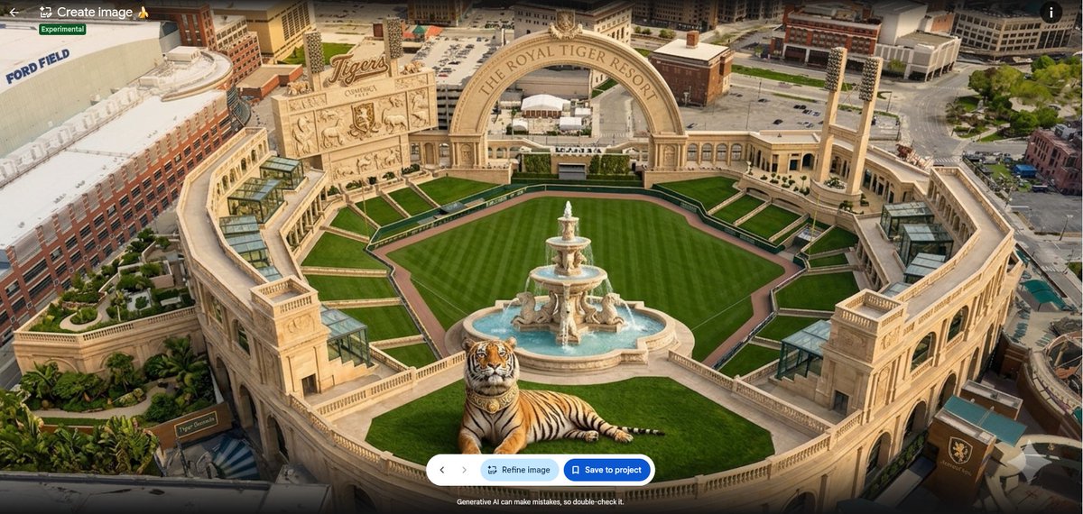
Google Earth

4.1K posts

Google Earth banner
Google Earth

Google Earth

@googleearth

Discover geospatial datasets and tools, AI capabilities, and planetary-scale insights from Google Earth, Google Earth Engine and Google Maps Platform

Mountain View, CA Katılım Nisan 2009
287 Takip Edilen1.1M Takipçiler
Google Earth
Google Earth@googleearth·
We are proud to announce that Google Earth’s data layer coverage has expanded globally 🌍 Learn more 👉 goo.gle/3NJouiW Every high-stakes project happens somewhere. But getting context about that "somewhere" shouldn't require a scavenger hunt. 🌍 Today, we're bringing massive data improvements to Google Earth so you can stop wrangling data and start making decisions: 1️⃣ Global data layer expansion 2️⃣ Google Earth Engine raster data layers 3️⃣ Ask Google Earth data layer integration (Note: Ask Google Earth is currently in Experimental for US web users)
English
11
81
499
21.5K
Google Earth
Google Earth@googleearth·
Satellite embeddings are lowering the barrier to building with Earth observation data. Discover how to build scalable, native vector search applications using Google DeepMind's AlphaEarth Foundations, Google Earth Engine, and BigQuery. Learn from our expert partners at Spatial Informatics Group and Earth Resources Technology, Inc as they walk you through seamless Extract, Load, Transform (ELT) workflows to bring powerful geospatial insights to any app. 🚀 Read the full guide here: goo.gle/4sTviJW @BiplovBhandari @sig_gis
Google Earth tweet media
English
7
91
616
25.9K
Google Earth
Google Earth@googleearth·
Whether you are a built-environment pro validating ground truth or a public sector leader managing infrastructure, our professional plans are designed to help you do your best work. There is only one Earth. In 2026, let’s put it to work. 🌍 goo.gle/4syrWM2
English
0
1
16
2.1K
Google Earth
Google Earth@googleearth·
3️⃣ Save time and work smarter with Google AI. We are entering the era of agentic geospatial intelligence. Ask Google Earth already makes it possible to turn natural language into professional-grade insights in seconds. This is just the beginning. 🧠⚡
English
1
1
18
2.3K
Google Earth
Google Earth@googleearth·
In 2025, we doubled down on evolving Google Earth into a professional-grade geospatial platform. In 2026, we’re hitting the accelerator. 🏎️💨 Our mission: Empower professionals to transform their businesses, their cities, and the planet. Here is what we're building this year 🧵👇 goo.gle/4syrWM2
English
14
61
439
25.4K
Google Earth
Google Earth@googleearth·
There's only one Earth. Put it to work. 🌍 Start a free trial of Earth's new professional plans today. ➡️ goo.gle/4bpyLJ8
English
2
46
372
21.9K
Google Earth
Google Earth@googleearth·
We are thrilled to announce that Google’s Satellite Embedding dataset, powered by @GoogleDeepMind's AlphaEarth Foundations model, has been updated for 2025. This additional year of coverage now unlocks the ability to look back, compare, and detect change across the planet with unprecedented clarity. Learn more here ➡️ goo.gle/3NdIxWn Part of Google's Earth AI, the new data represents the state of the planet throughout 2025, distilling petabytes of multi-sensor data into a 64-dimensional embedding for every 10 meter pixel. What’s new in this update? 🧵👇 - 🌍 2025 Data: The state of the planet throughout 2025 is now available on the Earth Engine Data Catalog and Google Cloud Storage. - 🔬 Unprecedented Change Detection: Because these embeddings capture subtle spectral, spatial and temporal signatures, they make it easy to spot significant year-over-year changes without the heavy lifting of raw image processing. - 💚 Long-term Commitment: We are formalizing our commitment to the ongoing production of these annual layers to support your operational workflows. Since we first launched the Satellite Embedding dataset, we’ve been inspired by how our community is putting this data to work. Applications are ranging from ecosystem mapping and agricultural crop-typing to carbon stock prediction. We can’t wait to see what you do next. #EarthEngine #GeoAI #DeepMind
Google Earth tweet mediaGoogle Earth tweet mediaGoogle Earth tweet media
English
47
393
3.1K
207.1K
Google Earth
Google Earth@googleearth·
🌍 Renoster uses @GoogleDeepMind and Earth AI's AlphaEarth Foundations embeddings for carbon mapping. Check out this post ➡️ goo.gle/4b8yvix Learn more about their process and follow along to see how they train and evaluate an embeddings-based regression model for mapping forest height in Maine. 🌲🛰️
Google Earth tweet mediaGoogle Earth tweet mediaGoogle Earth tweet media
English
3
36
215
11.4K
Google Earth
Google Earth@googleearth·
The budget is set in the boardroom, but it can break on the ground if site assessments are overlooked. 📉 Developers are saving time and derisking investments by evaluating sites without leaving their desk. Try it yourself ➡️ goo.gle/4rt27gi Protect your time and budget with powerful data layers and imagery like: Zoning data: Is the site available for our project? Terrain layers: Does the slope require expensive grading? Rich imagery: Can we confirm our analysis without a site visit? #GIS #BIM #Sustainability #Agriculture
English
7
21
168
11.8K
Google Earth
Google Earth@googleearth·
A massive influx of tourists requires EV infrastructure that can support surges ⚡️ goo.gle/46VI1Tx Use new EV infrastructure data layers like charging station location, charging station counts by postal code, driveway counts, and more in Google Earth to identify the optimal locations to invest. In the US, go even further with EV charging station search interest and outbound, inbound, and intrabound monthly vehicle trips! #Energy #EVCharging #Sustainability
English
7
36
182
11.3K
Google Earth
Google Earth@googleearth·
Import, style, and filter geospatial data in seconds. See your data on Google Earth's real-world canvas to make better decisions, faster. From selecting your next dinner reservation to your next site. The work starts #onEarth ➡️ goo.gle/4tQcVa6
English
3
28
205
10.5K
Google Earth retweetledi
Google Maps Platform
Google Maps Platform@GMapsPlatform·
🚨 Discord drop: If you haven't joined the Google Maps Platform Discord yet, now's your chance: goo.gle/3MhnaDp Tomorrow, hear from two of the top voices in geospatial development as they explore how AI could change mapping forever. If you're interested in learning more about geospatial AI, we invite you to join our Discord for community content and conversation.
English
4
5
24
3.3K
Google Earth
Google Earth@googleearth·
Gridlock isn't an accident. It's a data problem. 🚦 goo.gle/4aEglUi Moving millions of people through a city requires more than just a map. Planners need deep mobility insights to predict and optimize the flow of traffic. Import custom traffic data directly into Google Earth to visualize bottlenecks and opportunities. Combine your data with powerful data layers like: - Inbound, outbound & intrabound monthly vehicle trips to visualize high traffic areas. - Traffic signal level of service to identify bottlenecks. - Driveway counts to minimize conflict zones. Data layers vary in coverage throughout the globe.
English
6
19
160
9.1K
Google Earth
Google Earth@googleearth·
Terrain analysis can be make or break for a project.🏗️ goo.gle/4kB1dvC Mitigating risk when big deadlines are at play is essential. Even in the city, the grade dictates the budget. Professionals in planning, construction, architecture and more use no-code tools in Google Earth to visualize topography before breaking ground. Combine powerful data layers, on-demand tools, and rich imagery to make better site selection decisions, faster. #googleearth #GIS #BIM
English
5
45
271
12.5K
Google Earth
Google Earth@googleearth·
From industrial rail yard to modern housing. A revitalization masterclass. 👏 goo.gle/4qxTBvh Transforming Porta Romana from an abandoned railway yard to modern housing isn't magic, it's data. Developers need parcel data, terrain analysis, and more to instantly validate which lots are candidates for revitalization projects. Don't waste months on the wrong plot. Validate your investment before you visit the site. #RealEstate #Construction #bim
English
0
17
145
6.7K
Google Earth
Google Earth@googleearth·
Global events are moments in time, but the infrastructure can last a century. 🏙️ goo.gle/4aIdRFG Before the first foundation is poured, planners face a critical question: Where will the legacy live on? It's not just about finding open space. It's about finding the best space. Using data layers like population density, household income, driveway counts, and more in Google Earth, developers can identify areas ripe for investment—turning a short-term event into long-term success. See the data behind the decision. #GoogleEarth #Geospatial
English
2
19
81
4.5K