Maa-amet

487 posts

Maa-amet banner
Maa-amet

Maa-amet

@maaamet

Estonian Land Board

Katılım Eylül 2010
84 Takip Edilen279 Takipçiler
Maa-amet
Maa-amet@maaamet·
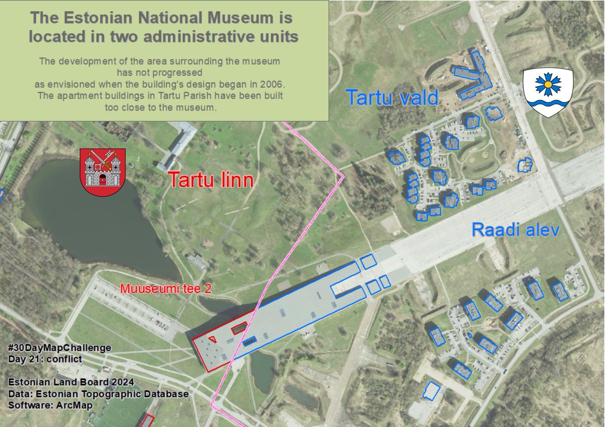
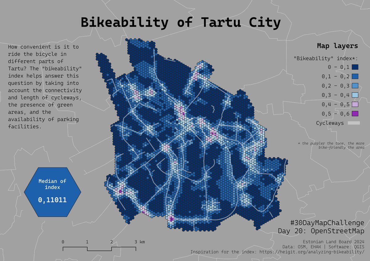
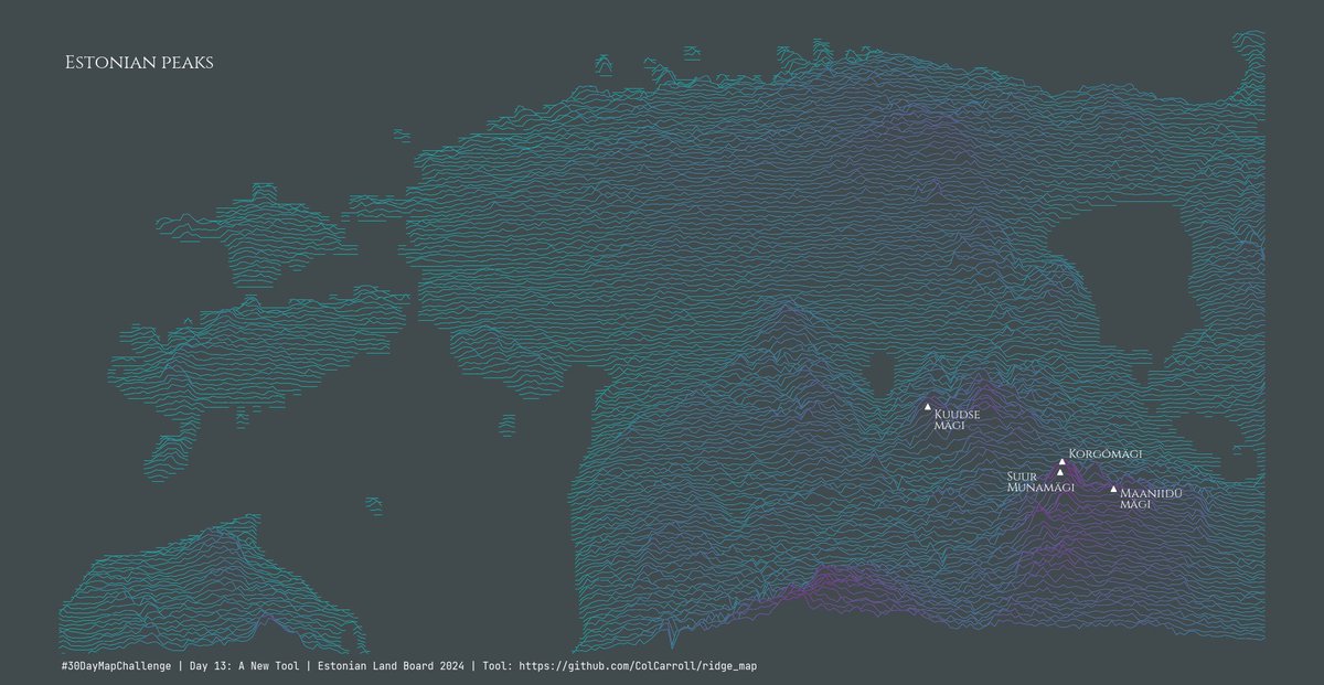
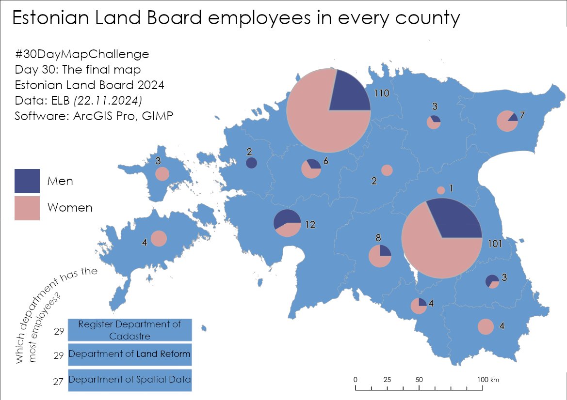
#30DayMapChallenge Day 30: The final map. This map is the last one we publish under the name of Estonian Land Board. Starting January 1st 2025, the Land and Spatial Development Board will begin its work, and, along with other organizations, we will be joining under its umbrella.
Maa-amet tweet media
English
0
0
5
192
Maa-amet
Maa-amet@maaamet·
#30DayMapChallenge Day 29 category: Overture. A constantly changing world requires the continuous updating of spatial data to reflect the most recent developments. The Overture Maps Foundation focuses on major challenges, including the collection and updating of open data.
Maa-amet tweet media
English
0
0
10
486
Maa-amet
Maa-amet@maaamet·
#30DayMapChallenge Day 28 category: The blue planet. The small treasures of the blue planet. Map describes Estonian fishing areas, species richness and recreational fishing quantities.
Maa-amet tweet media
English
0
1
8
301
Maa-amet
Maa-amet@maaamet·
#30DayMapChallenge Day 27 category: Micromapping. Small things have great meaning. The mapping of heritage knits keeps both heart and hands warm.
Maa-amet tweet media
English
0
0
1
92
Maa-amet
Maa-amet@maaamet·
#30DayMapChallenge Day 26 category: Map projections. Map projection is a way of representing a spherical surface on a flat surface. The created maps shows distortions of Estonia's position in unusual map projections.
Maa-amet tweet media
English
0
1
4
279
Maa-amet
Maa-amet@maaamet·
#30DayMapChallenge Day 25 category: Heat. When we think of the word "heat" during the gray and chilly month of November, many of us imagine an idyllic scene of a hot, sunny day on a southern sandy beach. But how many people with the surname Kuum (Heat) are there in Estonia?
Maa-amet tweet media
English
0
0
4
138
Maa-amet
Maa-amet@maaamet·
#30DayMapChallenge Day 24 category: Only circular shapes. Today's map is about roundabouts. Entering the roundabout may often be a fear for a novice driver. On this map, roundabouts are supported by carefully shaped municipalities, lakes and islands.
Maa-amet tweet media
English
0
1
5
192
Maa-amet
Maa-amet@maaamet·
#30DayMapChallenge Day 23 category: Memory. In Tallinn, "moving pictures" were shown for the first time in 1896 at the location of the current Eesti Draamateater in the Tallinn Stock Exchange building called Original-Bioskope.
Maa-amet tweet media
English
0
1
3
240
Maa-amet
Maa-amet@maaamet·
#30DayMapChallenge Day 21 category: 2 colors. Around 8% of Europeans are colorblind. The map featureas Estonia's administrative and settlement divisions, designed in subtle pastel shades.
Maa-amet tweet media
English
0
0
7
213
Maa-amet
Maa-amet@maaamet·
#30DayMapChallenge Day 21 category: Conflict: The Estonian National Museum is located in two administrative units. The conflict has arisen because the planning process is carried out by cadastral units.
Maa-amet tweet media
English
0
0
5
124
Maa-amet
Maa-amet@maaamet·
#30DayMapChallenge Day 20 category: OpenStreetMap. Today's "bikeability" map combines open-source OpenStreetMap data about cycleways, the proportion of green areas and bike parking facilities. The inspiration for creating the map comes from a study done at Heidelberg University.
Maa-amet tweet media
English
0
1
10
317
Maa-amet
Maa-amet@maaamet·
#30DayMapChallenge Day 19 category: Typography. This overview map of Muhu island and surrounding islets, located in Estonia uses only alphabetic characters from Latin typefaces. Six different font families are used to visualise map features.
Maa-amet tweet media
English
0
0
5
157
Maa-amet
Maa-amet@maaamet·
#30DayMapChallenge Day 18 category: 3D. 🏔️ The map is a hybrid of the old and the new, combining 2D and 3D elements. It features the oldest map in our historical maps application - Mellin's Atlas of Livonia (1796) - overlaid with the Estonian Land Board's elevation model.
Maa-amet tweet media
English
0
0
5
170
Maa-amet
Maa-amet@maaamet·
#30DayMapChallenge Day 17 category: Collaborative map. Can you see the three-dimensional image hidden within the autostereogram in the picture?
Maa-amet tweet media
English
0
0
7
183
Maa-amet
Maa-amet@maaamet·
#30DayMapChallenge Day 15 category: My data. January 1, 2025 is an important day – Estonian Land Board evolves into Land and Spatial Development Board. The map illustrates the offices across Estonia from 1st January 2025.
Maa-amet tweet media
English
0
0
6
137
Maa-amet
Maa-amet@maaamet·
#30DayMapChallenge Day 14 category: A world map. The entire observable universe, approximately 93 billion light years in diameter. "World" in Estonian means the whole universe, thus the planet Earth with known space, thus the entire universe.
Maa-amet tweet media
English
0
1
5
173
Maa-amet
Maa-amet@maaamet·
The worldwide #30DayMapChallenge has reached Estonian Land Board. For every day in November one new map will appear. Day 13 category: A new tool
Maa-amet tweet media
English
0
0
6
152
Maa-amet
Maa-amet@maaamet·
The worldwide #30DayMapChallenge has reached Estonian Land Board. For every day in November one new map will appear. Day 12 category: Time and space
GIF
English
1
0
5
123
Maa-amet
Maa-amet@maaamet·
The worldwide #30DayMapChallenge has reached Estonian Land Board. For every day in November one new map will appear. Day 11 category: Arctic
Maa-amet tweet media
English
0
0
6
280