Marcus Bailey

34.7K posts

Marcus Bailey banner
Marcus Bailey

Marcus Bailey

@marcusbailey

Christ is King 👑 @WISH_TV @StormTrack8 Meteorologist. Hoosier born & raised. Devoted husband & father- Colts/Pacers fan. @BallState Alum

Indianapolis, IN Katılım Aralık 2008
2.7K Takip Edilen6.2K Takipçiler
Marcus Bailey
Marcus Bailey@marcusbailey·
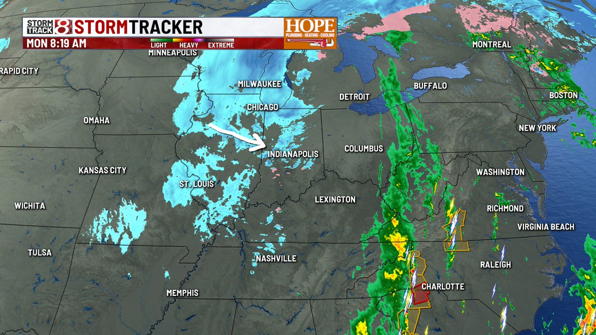
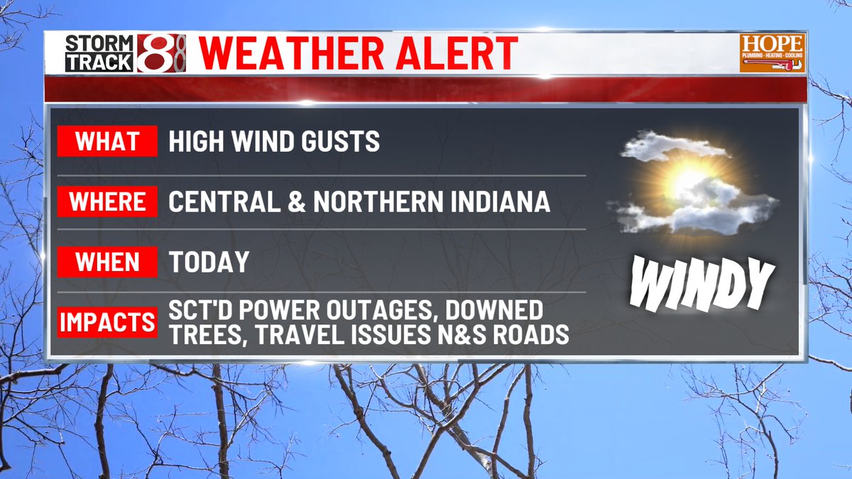
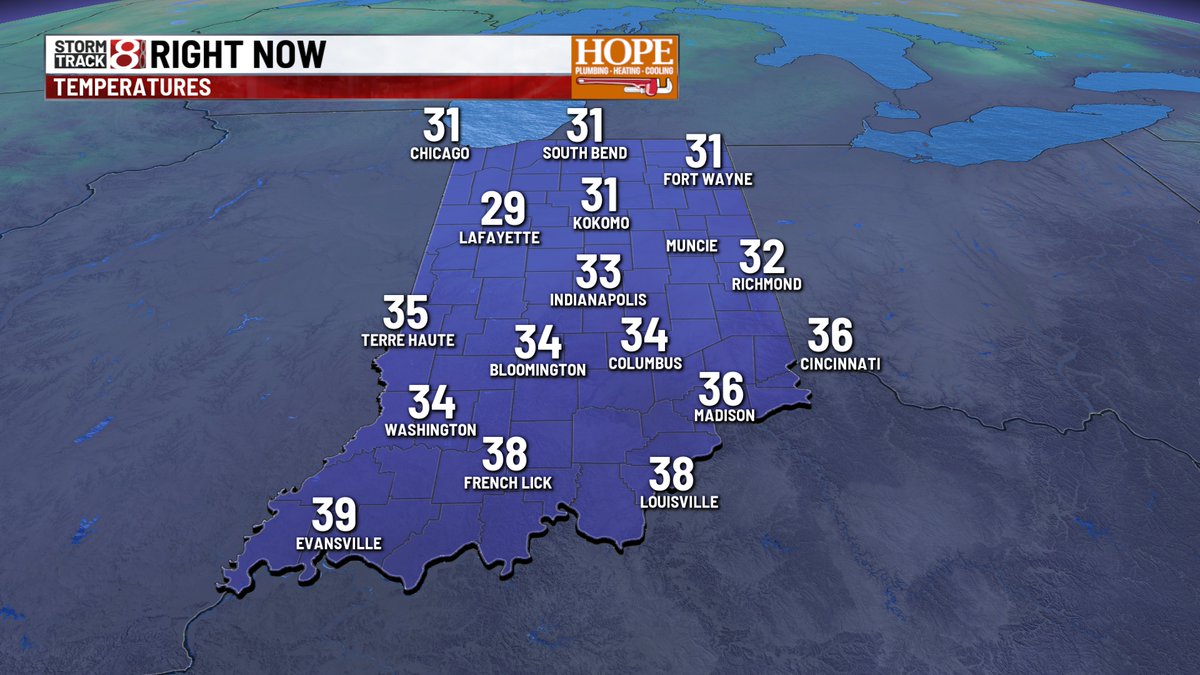
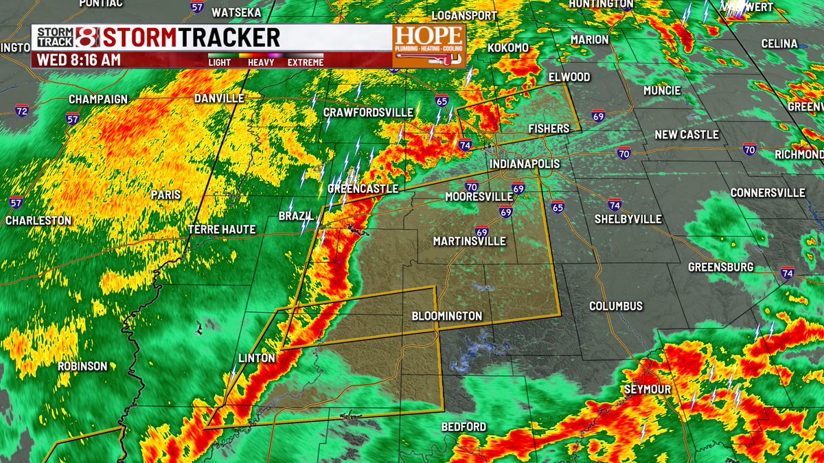
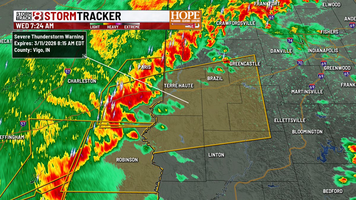
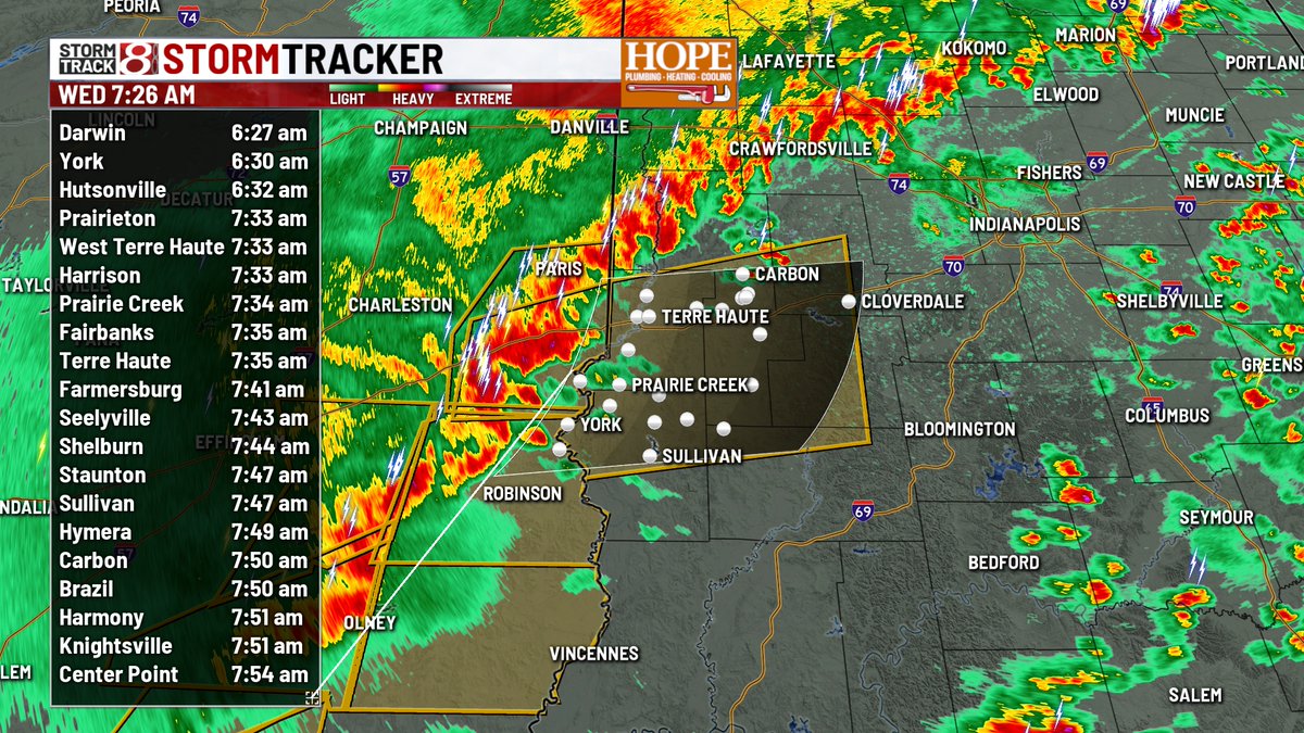
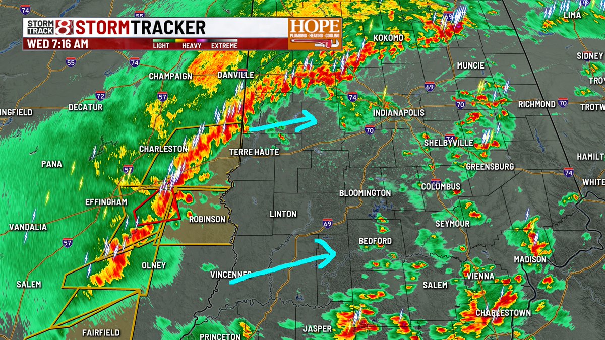
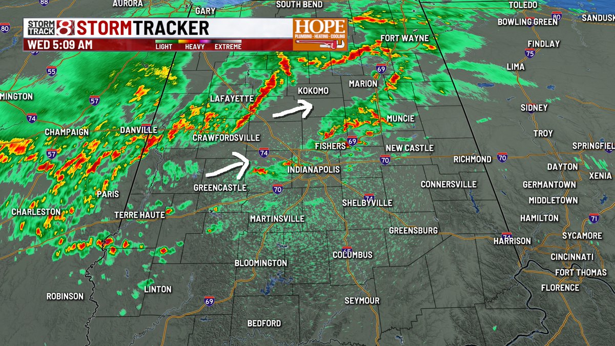
2:57 AM RADAR - Snow is showing up on radar, but we're not seeing much hitting the ground as of yet. Snow showers will continue to push over the state over the next few hours. A light coating is possible leading into the AM commute. #INwx
Marcus Bailey tweet mediaMarcus Bailey tweet media
English
0
0
3
180
Marcus Bailey
Marcus Bailey@marcusbailey·
TOP OF THE MORNIN'! - We still have some snow showers hanging around this morning - but should clear the area over the next few hours. This could be the coldest St. Patrick's Day since the early 1940s! #INwx
Marcus Bailey tweet mediaMarcus Bailey tweet mediaMarcus Bailey tweet mediaMarcus Bailey tweet media
English
0
3
5
1.1K
Marcus Bailey
Marcus Bailey@marcusbailey·
8:20AM RADAR - Scattered snow showers/bursts continue over central IN. We're cold enough now that some of the snow is sticking - especially bridges and overpasses. More snow on the way this afternoon. #INwx
Marcus Bailey tweet mediaMarcus Bailey tweet media
English
0
1
7
905
Marcus Bailey
Marcus Bailey@marcusbailey·
MONDAY - Temperatures will continue to fall through the day. Winds remain blustery, and scattered snow showers will become more widespread this afternoon. Up to 1" of accum. could make for a slow evening commute. #INwx
Marcus Bailey tweet mediaMarcus Bailey tweet mediaMarcus Bailey tweet mediaMarcus Bailey tweet media
English
0
1
3
1.1K
Marcus Bailey
Marcus Bailey@marcusbailey·
2:00 am - Cold front has moved through and the rush of colder, Canadian air is quickly pushing in. We're already down to 40°. Temperatures will continue into free fall mode for the remainder of the day. #INwx
Marcus Bailey tweet media
English
0
0
1
166
Marcus Bailey
Marcus Bailey@marcusbailey·
POWER OUTAGES - Over 21,000 custormers are without power across Indiana. The hardest hit county is Fulton county in northern Indiana, with just over 22% of the county out this morning. Bartholomew county as just shy of 4k without power. #INwx
Marcus Bailey tweet media
English
1
1
3
219
Marcus Bailey
Marcus Bailey@marcusbailey·
1:54 AM - Severe weather threat has passed the state. Gusty winds remain, and will continue through daybreak. #INwx
Marcus Bailey tweet media
English
0
0
0
138
Marcus Bailey
Marcus Bailey@marcusbailey·
GUSTY WINDS - Weather alert day for wind gusts over 50mph today. Winds will peak around lunch time out of the west. Some power outages and downed trees will be possible today. #INwx
Marcus Bailey tweet mediaMarcus Bailey tweet mediaMarcus Bailey tweet mediaMarcus Bailey tweet media
English
0
1
4
1.1K
Marcus Bailey
Marcus Bailey@marcusbailey·
We are nearly 40° colder this morning compared to Wednesday morning! The good news? We are in for a very quiet and bright day, with highs near the seasonal average later this afternoon. #INwx
Marcus Bailey tweet mediaMarcus Bailey tweet mediaMarcus Bailey tweet media
English
0
1
6
1.1K
Marcus Bailey
Marcus Bailey@marcusbailey·
TRAFFIC - Southern Johnson county - I-65 Southbound between Franklin and Edinburgh is CLOSED due to an overturned semi. #INwx
Marcus Bailey tweet media
English
0
0
5
278
Marcus Bailey
Marcus Bailey@marcusbailey·
TORNADO WARNING for Jay county until 9:30am. This is radar indicated. Very broad rotation near Redkey. Storm is moving northeast at 60mph #INwx
Marcus Bailey tweet mediaMarcus Bailey tweet media
English
0
1
4
266
Marcus Bailey
Marcus Bailey@marcusbailey·
8:27am RADAR - T-STORM WARNING continues for Hamilton county. Radar estimated winds are over 60mph on the front end of the line. #INwx
Marcus Bailey tweet mediaMarcus Bailey tweet media
English
0
1
3
898
Marcus Bailey
Marcus Bailey@marcusbailey·
8:17 am RADAR - Severe T-Storm Warnings now include parts of the metro area. Wind could reach up to 60mph. Storms are racing to the east/northeast at 65mph. #INwx
Marcus Bailey tweet media
English
0
0
3
210
Marcus Bailey
Marcus Bailey@marcusbailey·
SEVERE T-STORM WARNING for Vigo, Sullivan, Clay, Owen, and Greene counties. Up to 60mph winds possible. Some rotation has been noted at times with this storm. #INwx
Marcus Bailey tweet mediaMarcus Bailey tweet media
English
0
2
4
1.1K
Marcus Bailey
Marcus Bailey@marcusbailey·
7:16 AM RADAR - Severe storms are closing in on the Indiana state line. There's an area of rotation included in that line as well. The area between the blue arrows will be the concern for severe storms and possible tornadoes over the next few hours. #INwx
Marcus Bailey tweet media
English
0
0
2
250
Marcus Bailey
Marcus Bailey@marcusbailey·
POWER OUTAGES - Most of the outages in our state are up north in Lake, Newton, and Jasper counties, where over 3,000 customers are without power this morning. #INwx
Marcus Bailey tweet media
English
0
0
3
281
Marcus Bailey
Marcus Bailey@marcusbailey·
6:27 AM RADAR - TORNADO WATCH ISSUED until 12pm for central and southern IN. Concern is for storms in Illinois, and any isolated storms the develop ahead of that line. #INwx
Marcus Bailey tweet mediaMarcus Bailey tweet media
English
0
0
1
431
Marcus Bailey
Marcus Bailey@marcusbailey·
The NWS is considering issuing a watch over the highlighted area - watch probability at around 40%. So far storms are staying just below severe limits. #INwx
Marcus Bailey tweet media
English
0
1
0
445
Marcus Bailey
Marcus Bailey@marcusbailey·
5:09 am RADAR - Strongest storms are in northwestern portions of central IN - just east of Lafayettte. Wind gusts could hit 50mph with that line. Storms around the metro have lightning and heavy downpours. More storms to blossom through the AM commute. #INwx
Marcus Bailey tweet media
English
0
0
1
257