NWS Cleveland

27.6K posts

NWS Cleveland banner
NWS Cleveland

NWS Cleveland

@NWSCLE

Official X Account for National Weather Service Cleveland, Ohio. Details: https://t.co/OiJC4bi5HZ

Cleveland, OH Katılım Haziran 2012
556 Takip Edilen51.8K Takipçiler
NWS Cleveland
NWS Cleveland@NWSCLE·
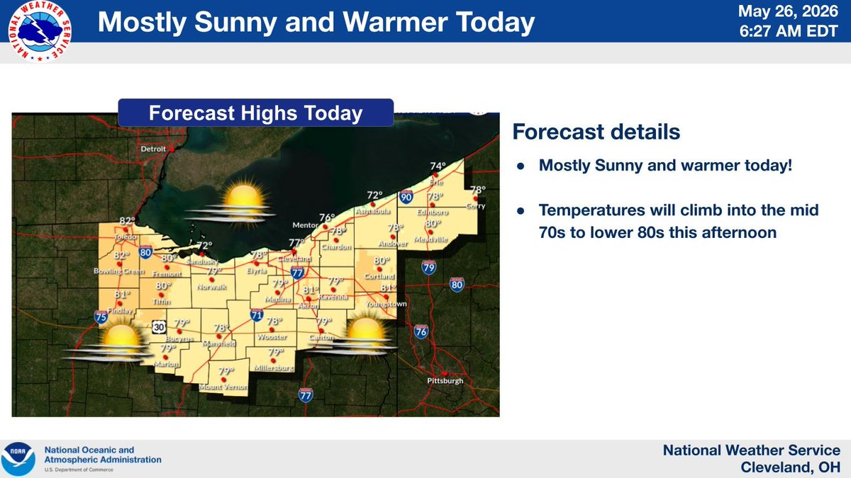
Mostly Sunny and warmer today! Temperatures will climb into the mid 70s to lower 80s this afternoon. #OHwx #PAwx
NWS Cleveland tweet media
English
0
6
31
3K
NWS Cleveland
NWS Cleveland@NWSCLE·
@Andrew71750296 Based on what the receiver at our office is playing on KHB-59's frequency, it sounds like the low-level inversion is causing some interference from KEC-63 in Michigan.
English
0
0
2
41
Andrew
Andrew@Andrew71750296·
@NWSCLE is KHB59 having issues on your end? Very static in bay village. Might be from tropo propagation.
English
1
0
0
19
NWS Cleveland
NWS Cleveland@NWSCLE·
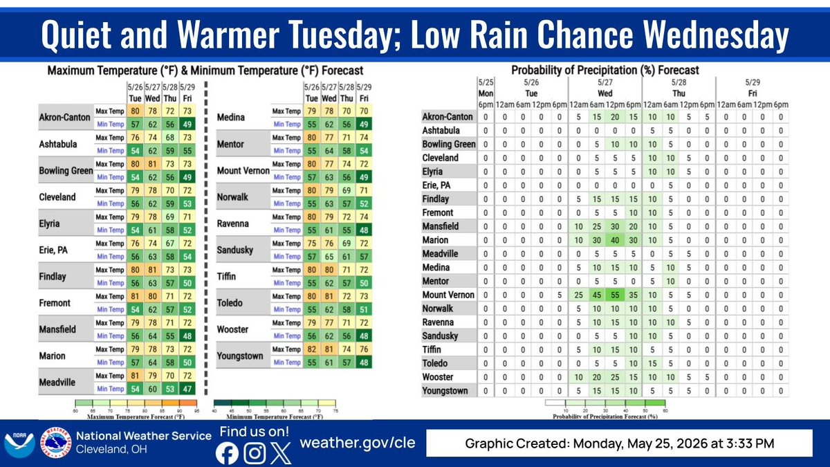
Much drier weather is expected this week as high pressure builds in. Highs will generally be in the 70s to low 80s, and lows in the 50s and 60s. There is a low chance of rain Wednesday afternoon, especially farther south.
NWS Cleveland tweet media
English
0
5
30
2.6K
NWS Cleveland
NWS Cleveland@NWSCLE·
Morning fog and low clouds will give way to afternoon sunshine. Temperatures will climb into the mid to upper 70s this afternoon. #OHwx #PAwx
NWS Cleveland tweet media
English
1
8
32
2.9K
NWS Cleveland
NWS Cleveland@NWSCLE·
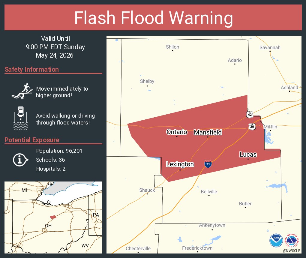
Flash Flood Warning including Mansfield OH, Ontario OH and Lexington OH until 9:00 PM EDT
NWS Cleveland tweet media
English
0
7
11
2.7K
NWS Cleveland
NWS Cleveland@NWSCLE·
Scattered showers and isolated thunderstorms are expected this afternoon into the evening with drier weather to start the week on Monday. Temperatures today will be seasonable, with highs in the mid to upper 70s. #OHwx #PAwx
NWS Cleveland tweet media
English
0
5
31
3.3K
NWS Cleveland
NWS Cleveland@NWSCLE·
After the widespread rain this morning, there will be a brief lull for most across the region. This afternoon, scattered showers/thunderstorms are likely with a few strong to severe storms possible, primarily in north and central OH. #OHwx #PAwx
NWS Cleveland tweet media
English
1
7
37
3.8K
NWS Cleveland
NWS Cleveland@NWSCLE·
Thank you for joining us for BOTH National Safe Boating Week and Heat Safety Awareness Week! For more information, visit: 🚤 arcg.is/aKvuO0 ☀️ heat.gov
English
0
8
20
2.1K
NWS Cleveland
NWS Cleveland@NWSCLE·
Showers are on the doorstep of the southern tier of counties this afternoon. These showers will gradually spread north throughout the evening. Heavy rain is possible at times, but no severe storms are expected. #ohwx #pawx
NWS Cleveland tweet media
English
0
5
30
2.9K
NWS Cleveland
NWS Cleveland@NWSCLE·
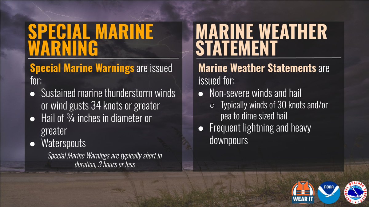
What’s the difference between a Special Marine Warning and a Marine Weather Statement? Thunderstorms over water can bring hazards such as gusty winds, hail, and even waterspouts. Get to shelter at the first sign of a storm! #SafeBoating #GreatLakes
NWS Cleveland tweet media
English
0
5
15
1.8K
NWS Cleveland
NWS Cleveland@NWSCLE·
Today is the final day of #HeatSafety Week! Friends don’t let friends get a sunburn. #DontFryDay! Here’s your safe summer checklist: ✔️ sunscreen ✔️ sunglasses ✔️ hat ✔️ protective clothing ✔️ shade
NWS Cleveland tweet media
English
1
4
16
1.5K
NWS Cleveland
NWS Cleveland@NWSCLE·
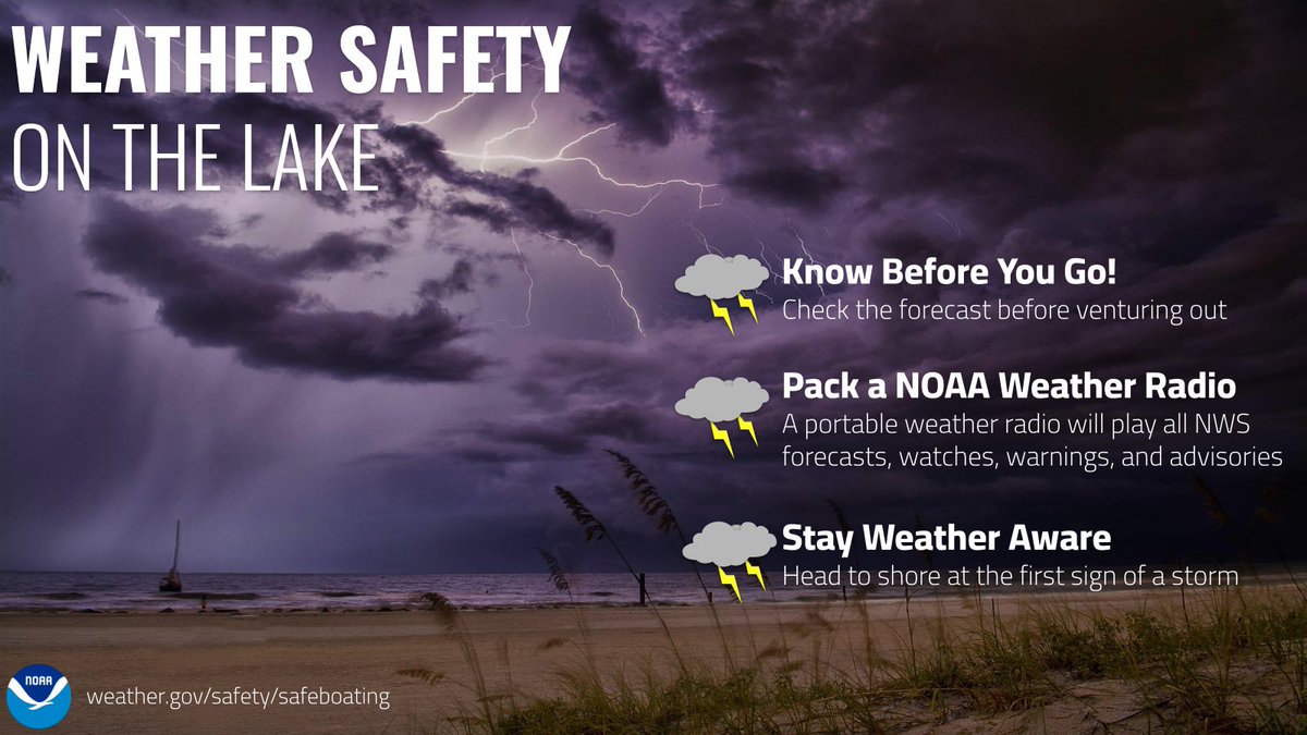
The final topic for National Safe Boating Week is Thunderstorm Safety. Thunderstorms can bring gusty winds, lightning, waterspouts and create dangerous wave conditions. #SafeBoating #GreatLakes
NWS Cleveland tweet media
English
0
8
14
1.7K
NWS Cleveland
NWS Cleveland@NWSCLE·
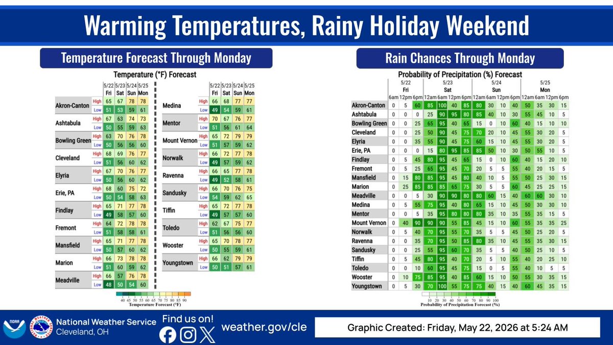
Rain will begin to move into the region late this evening and be off and on through early Monday morning with the heaviest rain expected to be tonight into Saturday morning. Temperatures will warm over the next few days as well, with highs in the upper 70s by Monday. #OHwx #PAwx
NWS Cleveland tweet media
English
0
8
30
3.1K
NWS Cleveland
NWS Cleveland@NWSCLE·
🌧️ Widespread rain will return late Friday through Saturday with the heaviest rain expected Friday night into Saturday morning. Rainfall totals will generally range between 1 and 1.5 inches, though isolated higher amounts near 2 inches are also possible.
NWS Cleveland tweet media
English
0
7
31
3.6K
NWS Cleveland
NWS Cleveland@NWSCLE·
Keep your cool when temperatures climb! 💧Hydrate, 👕wear light clothing and ☀️don't skip the sunscreen. If you start feeling dizzy, don't "tough it out"—seek medical help immediately. For more heat safety tips visit: weather.gov/safety/heat
NWS Cleveland tweet media
English
0
7
17
1.8K
NWS Cleveland
NWS Cleveland@NWSCLE·
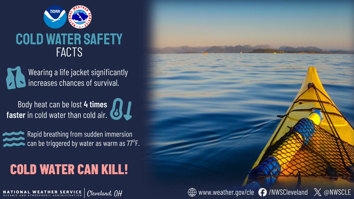
Even with high air temperatures, the lake can be cold. Always dress for the water temperature NOT the air temperature. Consider postponing small craft boating activities until the water temperatures are higher. #SafeBoating #GreatLakes
NWS Cleveland tweet media
English
0
11
20
1.9K
NWS Cleveland
NWS Cleveland@NWSCLE·
Another round of rain is expected to arrive late Friday, with the most widespread rain likely to occur Friday night into Saturday. More scattered shower chances linger for Sunday and Monday, with total rain amounts of 1.00-2.00" increasingly likely across the area. #OHwx #PAwx
NWS Cleveland tweet media
English
1
13
37
3.5K
NWS Cleveland
NWS Cleveland@NWSCLE·
Temperatures will be several degrees below average today with increasing amounts of sunshine moving in from the northwest. Any sprinkles south of US 30 early today will end by later this morning. #OHwx #PAwx
NWS Cleveland tweet media
English
0
9
28
2.2K
NWS Cleveland
NWS Cleveland@NWSCLE·
Children, the elderly, and those with chronic illness are especially vulnerable to heat exposure. Learn the signs of heat-related illnesses at weather.gov/safety/heat-il…
NWS Cleveland tweet media
English
0
6
12
1.8K