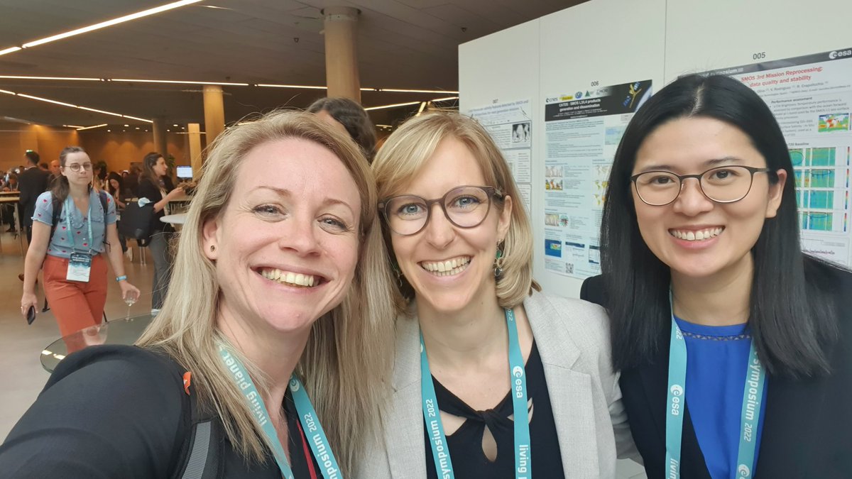
Olive Powell 🌍 (she/her)

1.9K posts

Olive Powell 🌍 (she/her) banner
Olive Powell 🌍 (she/her)

Olive Powell 🌍 (she/her)

@olivepowell

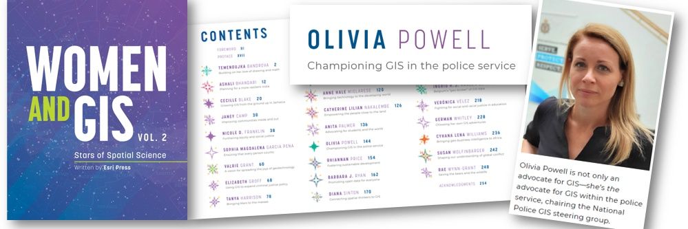
❤ #geospatial 🗺 | #HeadofGeo @ONS | #cgeog(GIS) #FRGS | Co-founder/Director @geospatialwomen | in @esri #WomenandGIS2 book | Views are my own.

From 🇨🇵, living in 🇬🇧 Katılım Mart 2011
1.2K Takip Edilen1.3K Takipçiler
Olive Powell 🌍 (she/her)
Olive Powell 🌍 (she/her)@olivepowell·
This is the wrap up of our ONS #30daymapchallenge to boost the org #geoskills. #Geo and #NonGeo professionals took part with varying levels of #competencies. That's why we do it ! 🤓( With my added rule of promoting @ONS data at the same time!) 🗺️🎓 #skills #learn #inclusion
ONS Geography@ONSgeography

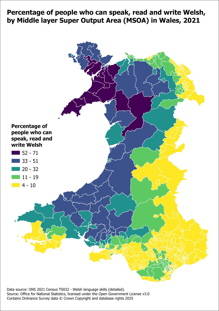
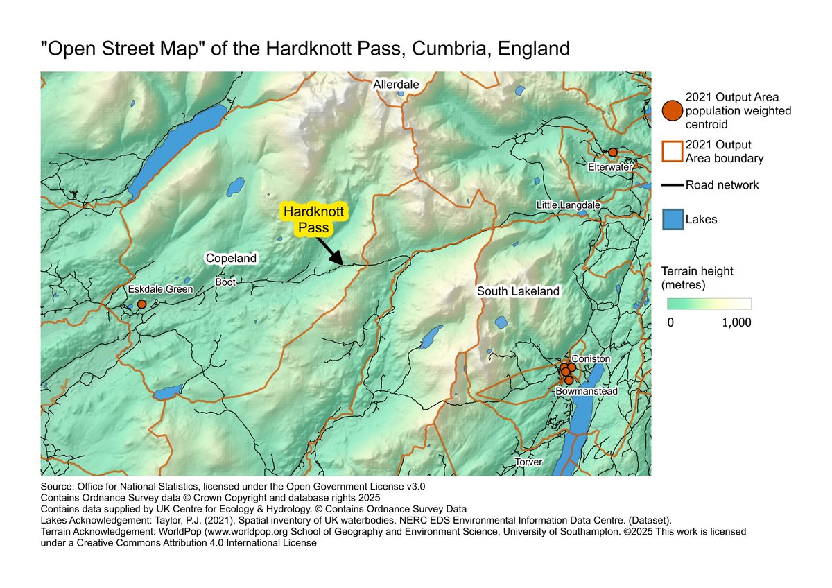
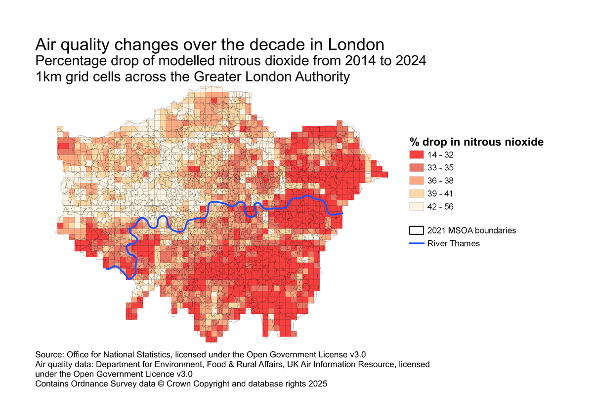
We hope you enjoyed following our #30DayMapChallenge contributions! Explore the full collection of maps created by ONS colleagues here: storymaps.arcgis.com/stories/ba595a…

English
0
0
0
77
Olive Powell 🌍 (she/her) retweetledi
ONS Geography
ONS Geography@ONSgeography·
#30DayMapChallenge Day 30: Makeover... of the 1958-1974 2LUSB field maps into digital residential footprints, more useable in the digital age. A flavour of what can be done with machine learning to extract residential footprints for ONS’s Historical Censuses Digitisation Project!
ONS Geography tweet media
English
0
4
5
296
Olive Powell 🌍 (she/her) retweetledi
ONS Geography
ONS Geography@ONSgeography·
#30DayMapChallenge Day 29: Raster. A map of the Lake District with the Ordnance Survey MiniScale raster, the National Park Boundary and ONS Output Area population weighted centroids available to download on the Open Geography Portal #GIS #Mapping #geospatial
ONS Geography tweet media
English
0
2
4
314
Olive Powell 🌍 (she/her) retweetledi
ONS Geography
ONS Geography@ONSgeography·
#30DayMapChallenge Day 25. Hexagons. A hexagonal map of Middle-Super Output Areas (MSOAs) in England and Wales, showing Census 2021 population estimates of residents living in households or communal establishments.
ONS Geography tweet media
English
0
2
5
238
Olive Powell 🌍 (she/her) retweetledi
ONS Geography
ONS Geography@ONSgeography·
#30DayMapChallenge Day 26: Transport. Estimated reachable number of jobs across GB by modality 🚌🚗🚴🚶Built by combining ONS Business Register and Employment Survey data with travel time estimates at Output Area level. Watch ONS Local Presents here: vimeo.com/user99857619/r…
ONS Geography tweet media
English
0
2
3
197
Olive Powell 🌍 (she/her) retweetledi
ONS Geography
ONS Geography@ONSgeography·
#30DayMapChallenge Day 23: Process. Which map would you choose? The ONS 'Geography and Statistics Training' provides guidance on the map-making process, as well as QGIS training and geospatial-specific courses for Python and R ➡️ onsgeo.github.io/geospatial-tra…
ONS Geography tweet media
English
0
2
4
287
Olive Powell 🌍 (she/her) retweetledi
ONS Geography
ONS Geography@ONSgeography·
#30DayMapChallenge Day 1: Icons. Highest concentrations of parks and pubs are found in central London, reflecting the diverse recreational opportunities in the heart of the city. Explore the data for 'Access to local amenities in England and Wales 2024': ons.gov.uk/peoplepopulati…
ONS Geography tweet media
English
0
2
4
213
Olive Powell 🌍 (she/her) retweetledi
ONS Geography
ONS Geography@ONSgeography·
#30DayMapChallenge Day 20: Water. This map shows the number of usual residents in England and Wales employed in fishing and aquaculture by Local Authority District. Data is from the 2021 Census #get-data" target="_blank" rel="nofollow noopener">ons.gov.uk/datasets/creat… #GIS #mapping #geospatial
ONS Geography tweet media
English
0
2
3
212
Olive Powell 🌍 (she/her) retweetledi
ONS Geography
ONS Geography@ONSgeography·
#30DayMapChallenge Day 17: A New Tool. Experiment 3D rendering with Aerialod. Population density from ONS 2024 Population Estimates and Census 2021 Lower Super Output Areas; normalised to area, then rasterised to 1km grid.   #GIS #Mapping #geospatial
ONS Geography tweet media
English
1
7
15
11.4K
Olive Powell 🌍 (she/her) retweetledi
ONS Geography
ONS Geography@ONSgeography·
#30DayMapChallenge Day 12: Map from 2125 🔍🔮 What will the UK population be in the next 100 years? This time-series map uses 2022-based national population projections to show annual population change estimates up to the year 2122. Publication and data: ons.gov.uk/peoplepopulati…
GIF
English
0
2
3
230
Olive Powell 🌍 (she/her) retweetledi
ONS Geography
ONS Geography@ONSgeography·
#30DayMapChallenge Day 13: 10-minute map⏳Once the data was downloaded, we set the timer and made this map of people who speak, read, and write Welsh. The data is from Census 2021 downloaded from the Nomis website (TS032 - Welsh language skills) nomisweb.co.uk/sources/census…
ONS Geography tweet media
English
0
4
8
1.6K
Olive Powell 🌍 (she/her) retweetledi
ONS Geography
ONS Geography@ONSgeography·
#30DayMapChallenge Day 14: OpenStreetMap. We ❤️OSM but here's our fun take on 'open streets'... An “open street map” in England. OS Open Roads data show the remote (open) road. Population weighted centroids emphasises the “openness” of the areas these roads pass through 🛣️
ONS Geography tweet media
English
0
2
4
241
Olive Powell 🌍 (she/her) retweetledi
ONS Geography
ONS Geography@ONSgeography·
#30DayMapChallenge Day 11: Minimal. Scotland, Northern Ireland, Wales, and England — the countries of the UK. Source: Office for National Statistics (ONS) Open Geography Portal, December 2024 UK generalised clipped boundaries (BGC). Download here: geoportal.statistics.gov.uk #GIS
ONS Geography tweet media
English
0
2
2
276
Olive Powell 🌍 (she/her) retweetledi
ONS Geography
ONS Geography@ONSgeography·
#30DayMapChallenge Day 9: Analogue ✏️ Paths Arthur the dog likes to travel on his daily walks, his favourite sniffing spots, rocks for hopping and houses where other dogs live. Included are the UPRNs of landmarks along the way (the RNLI station, Pubs, Rugby clubs and the beach).
ONS Geography tweet media
English
0
2
7
298