
Tradd Siegling
1.8K posts

Tradd Siegling
@traddsi
@lolesports guy /
South Carolina, USA Katılım Haziran 2017
1.5K Takip Edilen112 Takipçiler
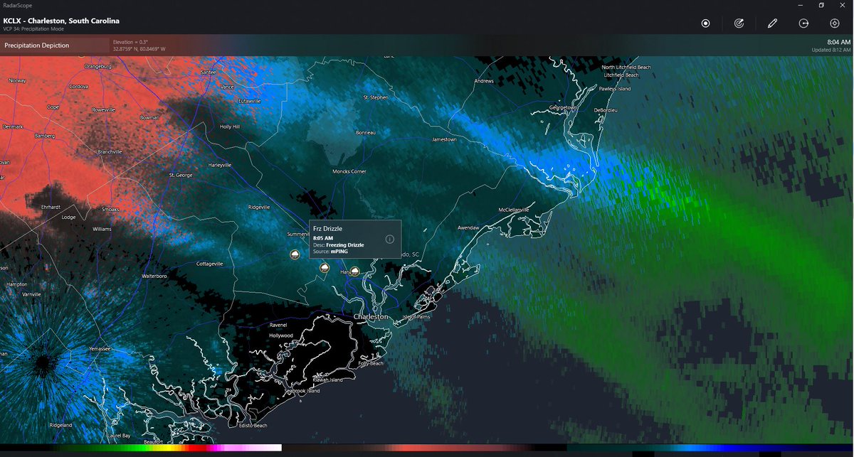
@NWSCharlestonSC light glaze of ice accumlinating on railings and sidewalks in Hanahan
English
I have a little PTSD, but there's good momentum downstream, so we're in good shape.
Jake Jones@jake_jones82
@jamiearnoldWMBF please don’t tell me that we are under another dry bubble like few years ago! What is this. ??
English
@SCweather_wx Importantly no sleet at the coast with that NW trend the snowfall totals (in theory) should increase for all
English

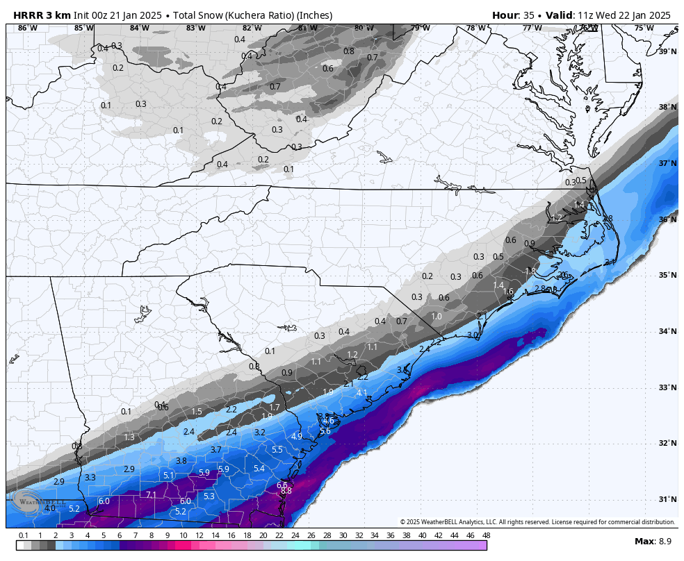
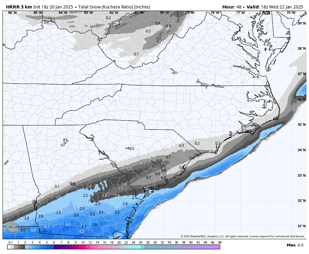
HRRR has been the stubborn one so far.
But comparing the 00z HRRR to the old 18z HRRR, you can see how the footprint of snow increases a lot.
You don't have much of a push NW with it, but if you keep pushing the heavier moisture further inland, then it will eventually respond with a NW push.
English
@Gabriel13za @AndrewC49247947 @SCweather_wx Thing is the “NW Trend” has no real base expect from people who just want it to happen for the extra winter weather. If anything the SE trend has actually prevailed over the last 12-18 hours.
English

@traddsi @AndrewC49247947 @SCweather_wx right? LMAO every time i read a "NW trend" my heart shatters
English
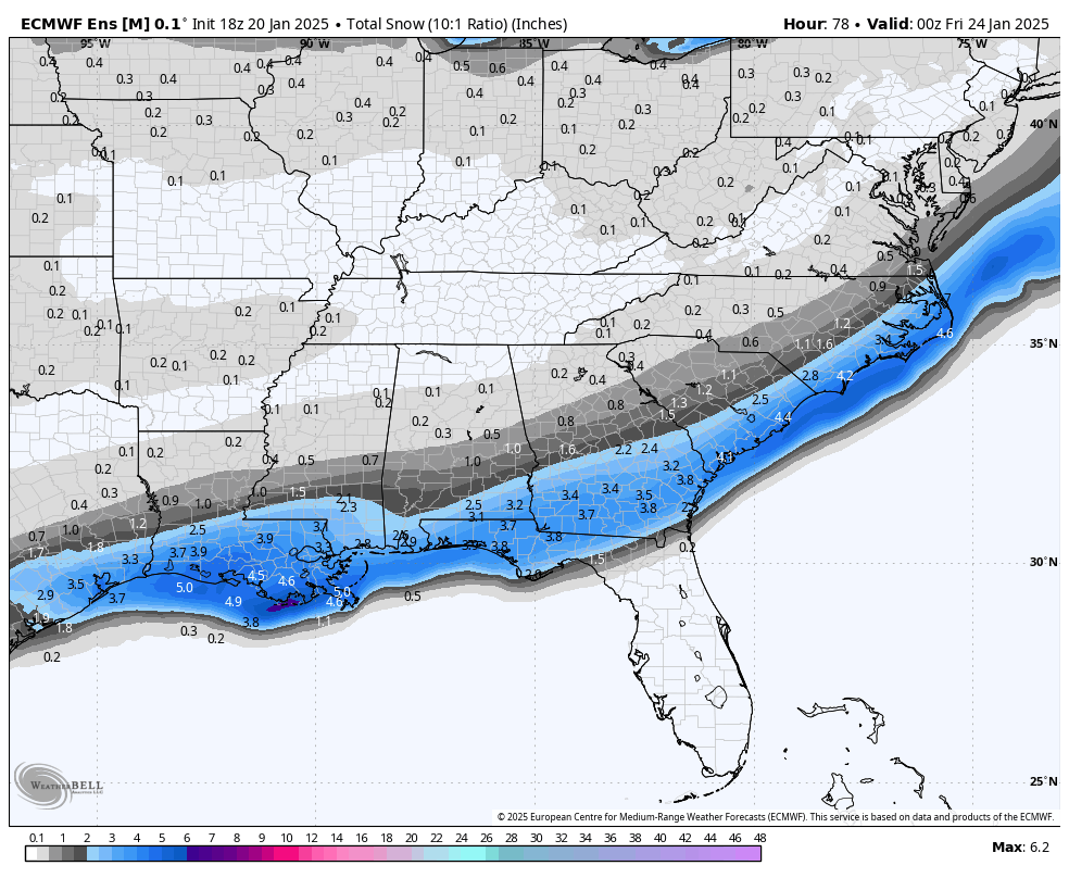
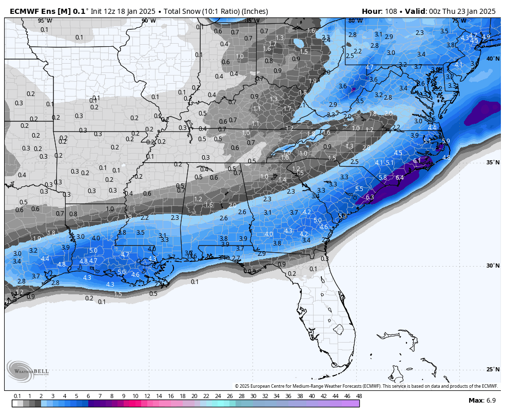
Latest 12z EPS below. It holds & actually increases for many.
What I am noticing is that it's increasing INSIDE the original footprint of snow & the edges are getting tight as far as a cut off. Either way we will continue to see wobbles one way or the other. Just goes to show you how members are starting to zero in & someone is going to be on the wrong side punching air.
I was on the wrong side on January 3rd 2018 so I know how that feels.
English
@AndrewC49247947 @SCweather_wx Yea, sleet totals could be an issue toward the immediate coast but I think most of the Charleston metro will still get at least 1-2in if not more depending on the track of the low
English

@traddsi @SCweather_wx i would worry more about sleet that’s what ruins snowfall totals
English
@AndrewC49247947 @SCweather_wx We aren’t raging, hearing about this “NW trend” puts a dent in any raging yet
English
@SCweather_wx close to a 6 inch mean in charleston they gotta be raging there
English
@SCweather_wx And it’s everywhere in SC as well, the Lowco seems to be getting in on this as well. The storm for everyone to rage for has arrived.
English
Frame it.
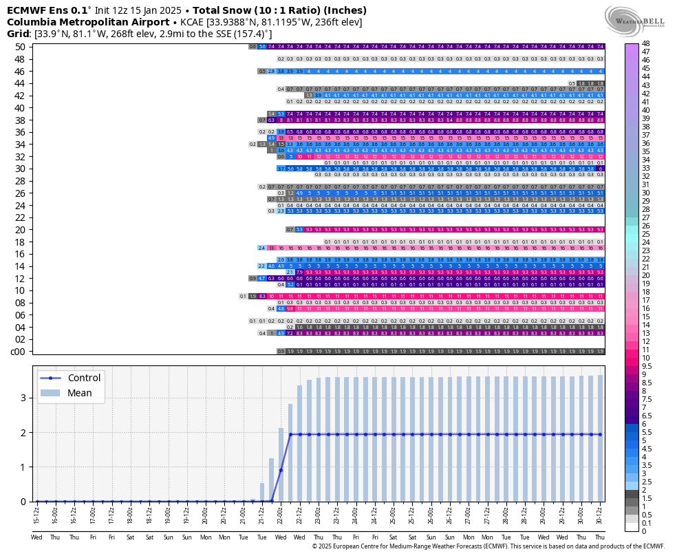
I ain't ever seen snow on an EPS run for CAE like this in my life. If only it could hold. One can only hope it could show this by this coming Sunday & Monday.
English
Sleet has finally gotten lighter but still falling, some accumulation on the roads but nothing crazy.
English
Moderate sleeting occurring again in Hanahan @NWSCharlestonSC significantly heavier then the last batch of sleet.
English
@SheaGibsonWx It is also Sleeting in Hanahan, Although it is pretty light sleeting
English

Getting reports of snow flurries in Summerville and a verbal report of snow flurries in Monks Corner. A little farther east just light freezing rain for now. #chswx

English
@SCweather_wx Sleet (Maybe freezing rain)/Rain Mix has already started in Hanahan
English
@SCweather_wx Guys we are 6 days out😭 let’s not read into every trend just yet, I want to rage as much as the next guy but we’ve been through this with hurricanes and other storm systems. Rarely does the track 6 days out actually verify.
English
And the 12z Euro comes in with a bit of a buzzkill.
That is ok.
We rage into the evening.
English
Great trends since this morning. Improvements for all model guidance for 12z to 18z. GEFS was the best in a couple days.
We move forward. Video will be up shortly.
English
@SCweather_wx 2,554 for the lowcountry 😭😭 We need a storm that will make everyone rage
English

@SCweather_wx 1073 days??? I’m so sorry
BAM Weather@bam_weather
It’s been almost two years since the National Weather Service office in Indianapolis issued its last Winter Storm Warning, marking the longest streak of any office in the Ohio Valley/Midwest! Surprisingly, Dallas, Texas has seen a Winter Storm Warning more recently!
English
@FloridaTropics1 Also important to note a MB decrease and east shift on on 00z GFS ensembles
English
English
@NbergWX And the GFS ensembles are east of the cone as well very interesting hours to come…
English

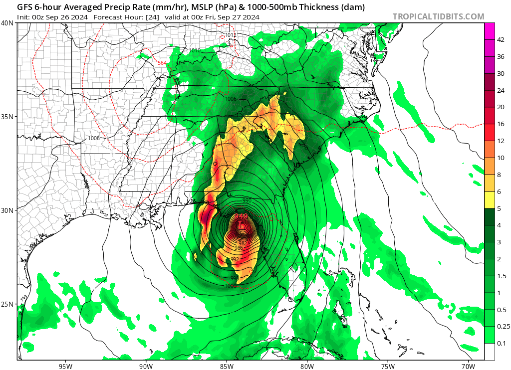
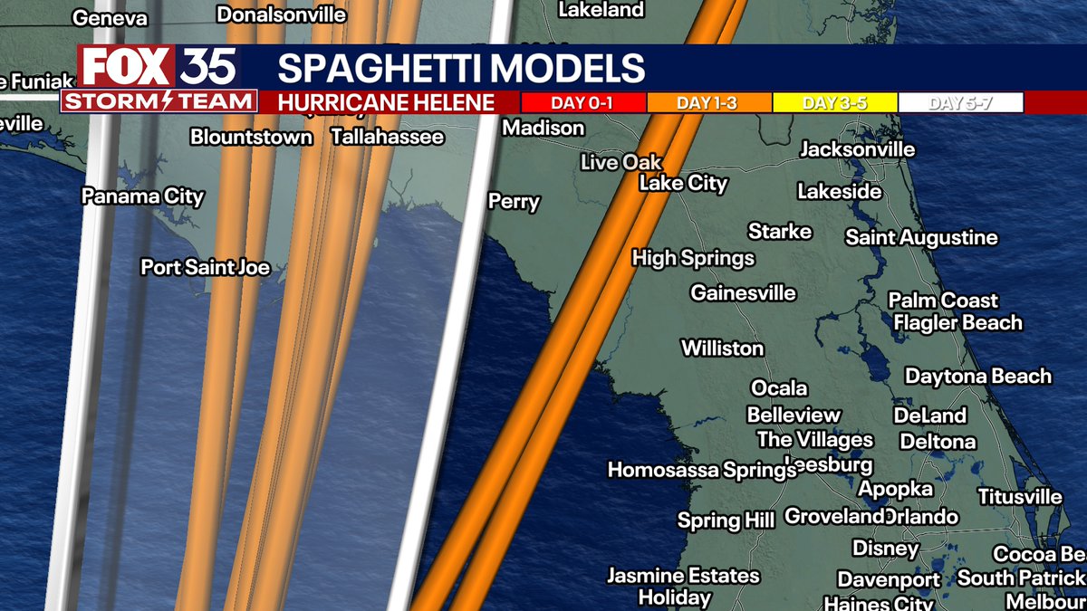
We need to keep close tabs with the track tomorrow for major Hurricane Helene. Some models, including the IBM, and the GFS modeling are consistently outside the "cone" and bring the eye of Helene closer to Cedar Key and the Lake City/Gainesville area. That would mean obviously significantly more wind gusts of hurricane force in the Ocala area, The Villages, and much stronger gusts closer to the Orlando area.
For now, the consensus and most likely idea remains the eye going up near Tallahassee but let's "nowcast" this storm carefully tonight into Thursday and monitor for any eastward shifts. If the eye does go to Tallahassee, central FL still gets Tropical Storm force gusts as advertised, but the Tallahassee area would get slammed with destructive winds and major outages.
Any and all subtle east shifts mean significant adjustments in the magnitude of wind/power outage/tornado risk in central-north-northeast FL.
English
@NWSCharlestonSC 2in of rain in the past hour (starting 1am) just south of the warning area in Hanahan
English
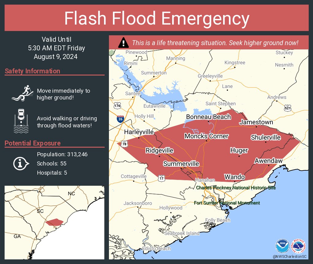
Flash Flood Emergency including Summerville SC, Goose Creek SC and Ladson SC until 5:30 AM EDT
English