low

132 posts

low banner
low

low

@verylow101

rechts

Katılım Haziran 2025
86 Takip Edilen16 Takipçiler
low
low@verylow101·
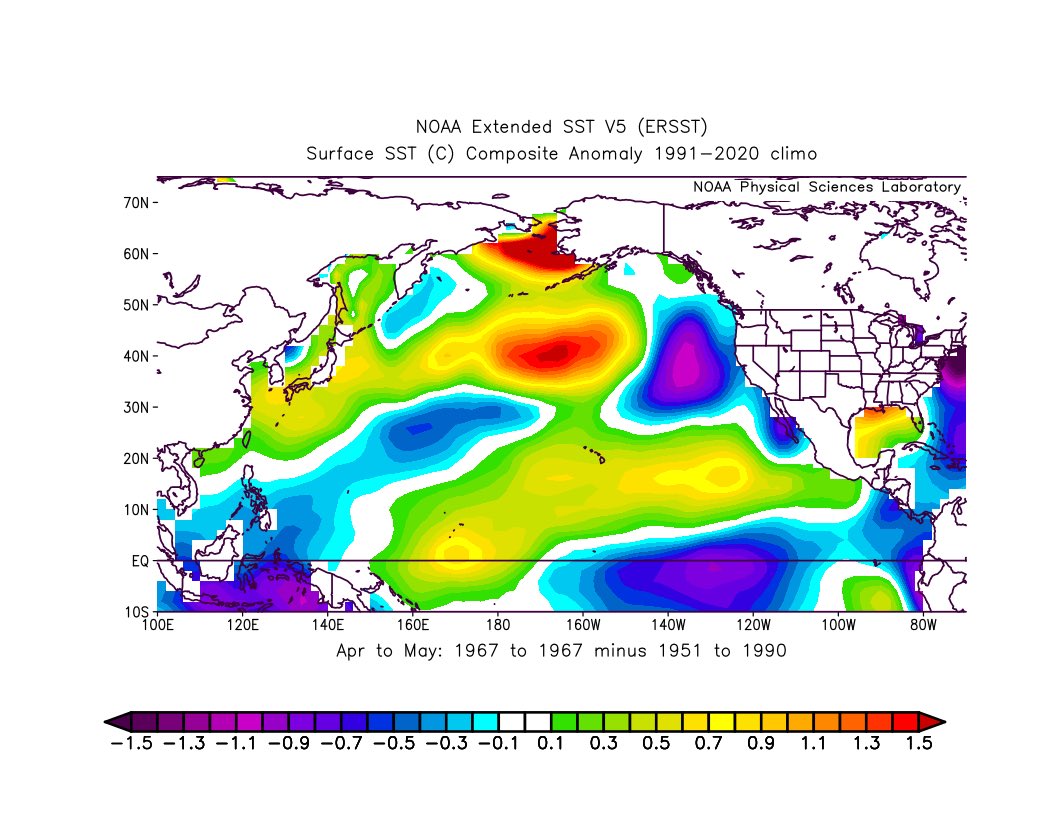
@webberweather 1967 is also an incredibly active Wpac Typhoon season. JWTC underestimated the ACE greatly.
English
0
0
0
227
Eric Webb
Eric Webb@webberweather·
It is very encouraging to see even non-El Nino years that match a lot of this year’s internal mid-latitude variability still end up with active Junes 🌪️. 1967 is probably a good example of this.
Eric Webb tweet mediaEric Webb tweet mediaEric Webb tweet mediaEric Webb tweet media
English
4
8
85
7K
low
low@verylow101·
@CycloforumsPR The most sensitive part for total ACE is probably the late season OND. Some El ninos tend to taper off significantly late due to the ICTZ being pushed too far south and trade surges. 2015 had an incredible heads start until August but 1997 came on top because of October onward.
English
0
0
2
116
CycloforumsPR
CycloforumsPR@CycloforumsPR·
@verylow101 WPAC has begun fast with ACE of 42.5. Agree that this basin will have many typhoons cat 3+.
English
1
0
1
239
low
low@verylow101·
@JontheGamerBoy @AlanSevere 2009 is not a good analog, our El nino will be much stronger. By ASO 2009 was only in weak Nino while we could already be ~2°C.
English
1
0
1
91
JonIsDaBest
JonIsDaBest@JontheGamerBoy·
@verylow101 @AlanSevere Yeah but those are all events way back when. More recent events like 2009 and 2015 were closer to 60. In fact, we may end up in the 70’s for ACE bc SST are slightly more favorable especially in the SW Atlantic and GOM, and the AMO signature is not as cold as those years
English
2
0
0
82
low
low@verylow101·
@JontheGamerBoy @AlanSevere I doubt this low as well but its certainly not impossible. ~30 ACE has been common place for some of past Ninos with cold atlantic. 1972, 1977, 1982, 1986, 1987, 1991, 1994 are all examples of this. 1997 with 40 ACE is not too far off despite the +AMO signature that year.
English
1
0
0
118
JonIsDaBest
JonIsDaBest@JontheGamerBoy·
@verylow101 @AlanSevere I doubt we go as low as 30. 2013 only got that low because shear was uniform and consistently high throigh the season. Even with Super El Nino you would need to keep a Spring pattern over the Atlantic through the entire season to achieve that.
English
1
0
0
136
low
low@verylow101·
@AndyHazelton The "long tail" westward on these plots this year is another huge DKW associated with Sinlaku. This year is going to be wild. I honestly think both the strongest El nino in ~150 years and near record pacific TC activity is certainly possible.
English
0
3
12
848
Andy Hazelton
Andy Hazelton@AndyHazelton·
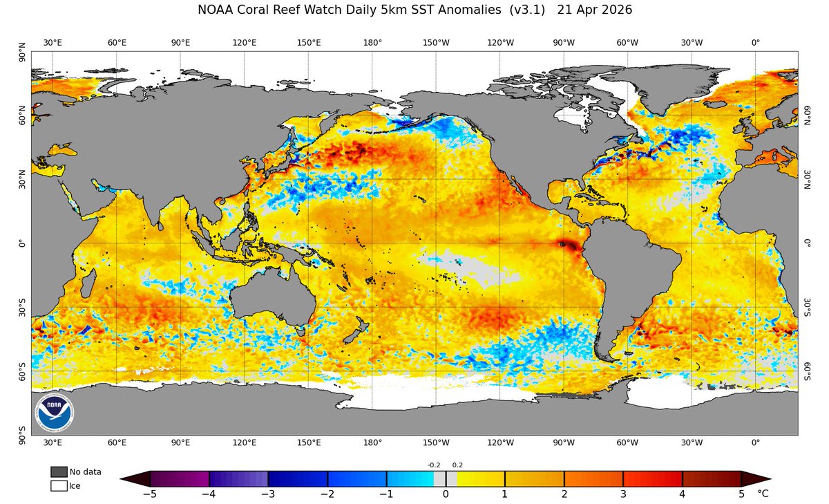
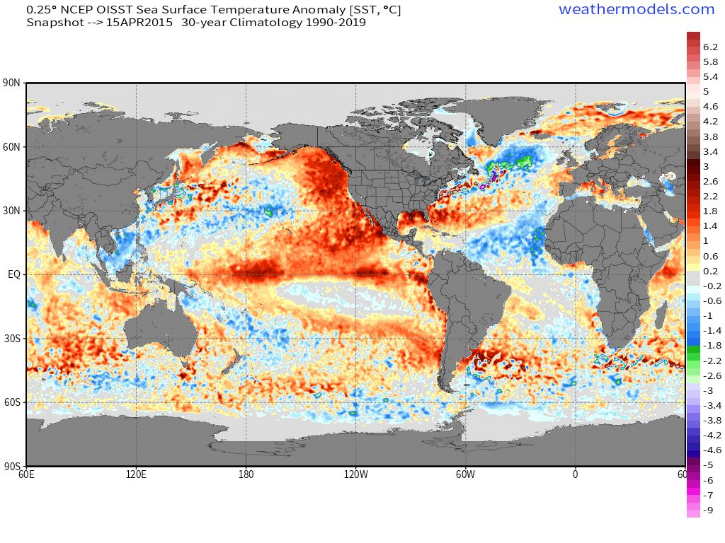
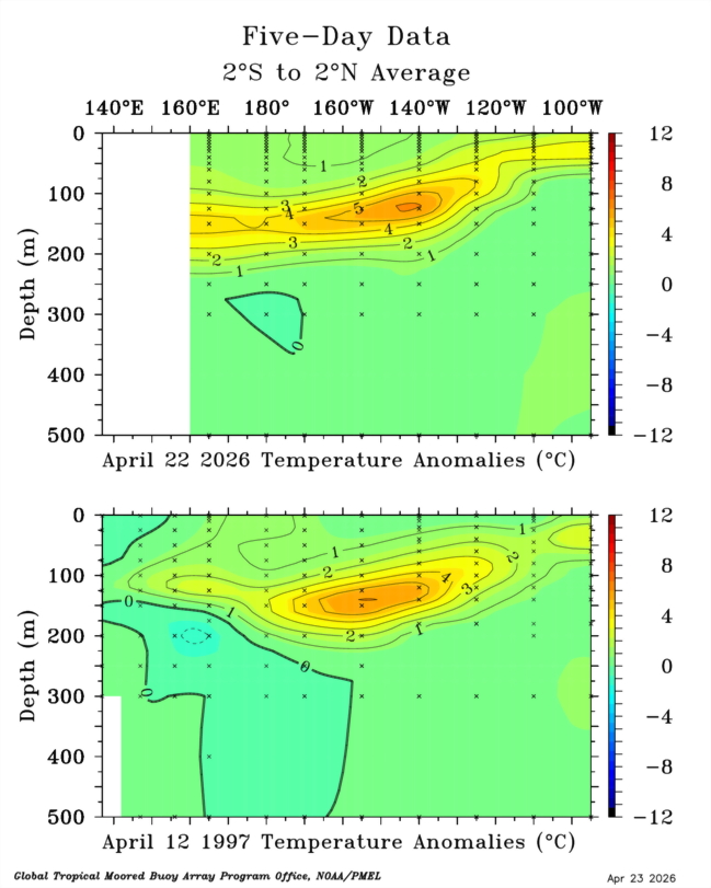
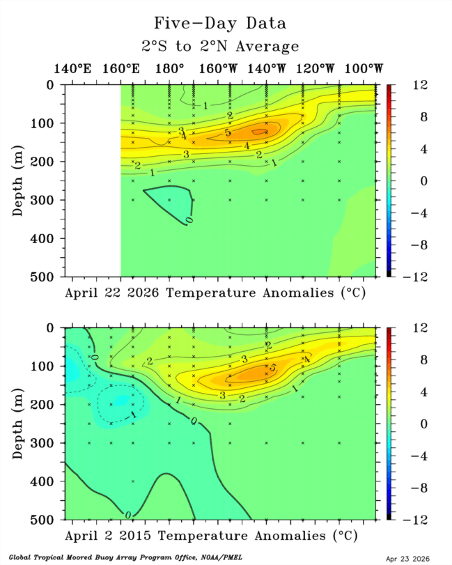
The downwelling Kelvin Wave over the Central Pacific is now slightly stronger than previous events (1997 and 2023) were at the same approximate longitude. There's also yet another downwelling wave yet to propagate east from the WPAC (driven by the last westerly wind burst). With weak trade winds forecast across the Pacific the next two weeks, there will be nothing to attenuate these Kelvin Waves, so they will continue to propagate east and lead to rapid warming of the Central and East Pacific as we progress into #ElNiño.
Andy Hazelton tweet mediaAndy Hazelton tweet mediaAndy Hazelton tweet media
English
7
46
192
14.3K
low
low@verylow101·
@AndyHazelton From the little data we have 1877-1878 seems to be the strongest El Nino out of all we know of. It would be very interesting to see how the 1877 one played out, but we know that it already started in late 1876 similar to 2014-2016.
low tweet medialow tweet media
English
0
0
0
144
low
low@verylow101·
@AndyHazelton Incredible. 2026 also had a much cooler starting position than either 1997 or 2015, which came from cold neutral and already weak El nino respectively. The 2020s have been exceptionally La Nina based and now we could be having the strongest nino since 1877-1878.
English
1
0
4
571
Andy Hazelton
Andy Hazelton@AndyHazelton·
Yeah, and those are weaker than I'd expect this one to be, especially 1951: webberweather.com/ensemble-ocean… 1877 and 1888 are two interesting ones from the 1800s that had some decent activity despite strong Niños. Both of those had a warm MDR, however. Very different than what we have now.
Andy Hazelton tweet mediaAndy Hazelton tweet mediaAndy Hazelton tweet mediaAndy Hazelton tweet media
English
1
0
1
116
low
low@verylow101·
@AndyHazelton @rushtropicalwx The +PMM this year is even more intense than 2015 at this point. We are quickly reaching similar ssts in the enso regions aswell. 1997 also flipped also right around this time of year. I expect the -PDO to weaken in summer as wind stress from recurving typhoons hits these waters.
low tweet medialow tweet media
English
1
0
2
126
Andy Hazelton
Andy Hazelton@AndyHazelton·
@rushtropicalwx @verylow101 Also, we don't have a classic +PDO like 2015, but it's extremely similar with the warmth off Mexico along with the developing Niño, and cold AMO. At this point 2015 is probably a very solid analog as far as what to expect fro the Atlantic and East Pacific seasons.
Andy Hazelton tweet media
English
1
0
4
216
low
low@verylow101·
@AndyHazelton @rushtropicalwx 2023 had pretty the cheat code to get around being dead lol. A decently strong -PMM and record atlantic ssts. Other El ninos have been active historically but none looked like this year. These being 1899 and 1951.
English
1
0
2
95
Andy Hazelton
Andy Hazelton@AndyHazelton·
@rushtropicalwx @verylow101 I don't see why it wouldn't when those are two good strong Niño analogs. Of course, no two events are the same. But, not different enough to, for example, magically make the Atlantic not dead. That's pretty much baked in to any strong Niño.
English
3
0
1
229
low
low@verylow101·
@AlanSevere @rushtropicalwx @AndyHazelton I think at this point Super nino is certainly the best forecast. The western pacific typhoon season and atlantic hurricane season are very unlikely to behave in any way similar to 2023. 2015 is a good guess when it comes the activity levels of Nhem TC basins.
English
0
0
1
56
Alan Snyder
Alan Snyder@AlanSevere·
@verylow101 @rushtropicalwx @AndyHazelton Anybody with a clean eye for this stuff would look at the right picture and say " Well there doesn't seem to me much in the way to stop this thing. maybe I should start leaning bullish "
English
1
0
1
47
low
low@verylow101·
@AlanSevere @rushtropicalwx @AndyHazelton Anyone still spewing this nonsense about this going the way of 2014 should take a look at the current SSTs and 850mb Hovmoller forecasts. 2014 did not have nearly as much westerly winds, it had a -SPMM, a failure mode we dont have etc...
low tweet medialow tweet media
English
1
0
1
69
low
low@verylow101·
@rushtropicalwx @AndyHazelton Considering the amount wind stress we had and the size of the DKWs its not an unlikely outcome that we have an El nino like 2015 or 1997. So far we match 1997s evolution quite well in terms of enso region SSTs. 2015 was already far ahead. 1982 matches well, 1972 has -PMM.
English
1
0
1
153
Rush Rush
Rush Rush@rushtropicalwx·
@verylow101 @AndyHazelton I've always maintained that there are some similarities between the 1982, and 1972 El Nino. But 1997 and 2015 are not on the list. Those are the favorate comparisons I see. My messgae has been that I don't expect this El Nino to behave like 1997 or 2015.
English
3
0
1
329
low
low@verylow101·
@rushtropicalwx @AndyHazelton Meanwhile the "failed El ninos" of 1981 and 2014 had a positive April PDO index. If wind stress and subsurface heat is strong the El nino does not care if there is a -PDO signal out there.
English
1
0
2
265
low
low@verylow101·
@rushtropicalwx @AndyHazelton Strong El ninos having a -PDO in April is not a rare occurrence. 2023, 2018, 2009, 2006, 2002, 1991, 1982, 1976, 1972 all had a -PDO index in April. This usually flipped during the year but it can also go the other way like 1994 which developed quite a decent -PDO later on.
English
1
0
1
219
low
low@verylow101·
@rushtropicalwx @AndyHazelton Its just a correlation, we had plenty of -PDO/+ENSO and +PDO/-ENSO combinations in the past. If wind stress in the tropics is strong enough you are bound to have a strong el nino regardless of -PDO. Monthly PDO index is more governed by ENSO than vice versa.
English
1
0
0
295
Rush Rush
Rush Rush@rushtropicalwx·
@AndyHazelton I don't believe its going to slow down El Nino either. But I do believe it will cause a "Novel" downstream impacts. Why? I have no analog to this setup. lots of similar setups but nothing quire the same. I dont know what those impacts are.
English
3
0
2
561
Alex Boreham
Alex Boreham@cyclonicwx·
I've added seasonal stats for the rest of the globe on cyclonicwx.com's homepage. It will be interesting to see how active some of the Pacific basins will get this year!
Alex Boreham tweet mediaAlex Boreham tweet mediaAlex Boreham tweet media
English
5
10
78
4.3K