Voxense

42 posts

Voxense banner
Voxense

Voxense

@voxense_

The Spatial DePIN Network on @solana 9ruvAhSYeRXqqAz1ffWyKzvPk4SJdLgtMWLXfz5Ppump

Katılım Kasım 2025
2 Takip Edilen250 Takipçiler
Sabitlenmiş Tweet
Voxense
Voxense@voxense_·
Voxense Map Is Now Live We are excited to announce that Voxense Map is officially live and can now be accessed at: map.voxense.network Voxense Map represents a major milestone in the expansion of the Voxense ecosystem. It introduces a fully interactive spatial visualization platform that brings real-time detections, sensor activity, and coverage data together in a dynamic 2D and 3D monitoring environment. This release strengthens the foundation of Voxense as we move toward a globally connected spatial intelligence network. What Is Voxense Map? 
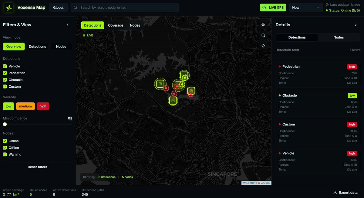
Voxense Map is the spatial monitoring interface of the Voxense ecosystem, designed to transform LiDAR-driven detections and AI insights into a clear, actionable, and intuitive visual experience. It allows users to explore environments in real time, switch view modes, analyze detections, inspect nodes, and gain full situational awareness through an advanced map-centric dashboard. Key Features 1. Real-Time Spatial Visualization View live detections, node positions, and active coverage areas on a 2D/3D interactive map with continuous updates. 2. Multi-Mode View Switching Easily toggle between: - Overview – holistic spatial layout - Detections – all AI-identified objects - Nodes – all active and inactive sensors 3. Advanced Filtering Controls Filter detections by type, severity, and confidence, or filter nodes by online/offline status and device category. 4. Detail & Metadata Panel Select any detection or node to instantly view complete metadata, including severity, confidence, coordinates, timestamps, and operational status. 5. Live Metrics Bar Monitor system activity at a glance, including coverage area, online nodes, and detection counts across multiple time windows. Benefits - Full situational awareness of environments in real time - Faster decision-making through clear visual intelligence - High spatial precision powered by LiDAR and AI - Stronger operational monitoring across complex environments - Foundational interface for future decentralized sensing and AI jobs 🔥 Part of the Voxense Ecosystem Expansion 
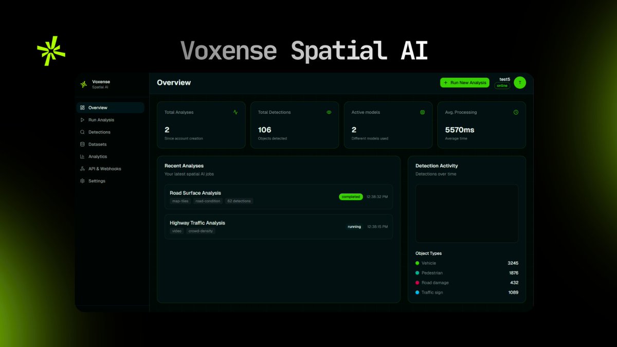
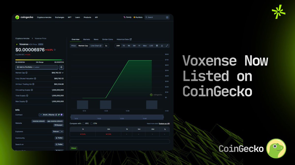
The launch of Voxense Map marks another step in the progressive expansion of the Voxense ecosystem following Voxense AI and ahead of the upcoming releases of Voxense Market and Voxense Node. Each module brings us closer to a unified, real-time, LiDAR-powered spatial network. #Solana #DePIN #voxense
English
26
6
50
3.8K
Voxense
Voxense@voxense_·
This is a multi-layer spatial stack: AI → Map → Market → Node. Each component depends on the previous one, so we roll it out sequentially and transparently. Some pages look placeholder because the backend models, job schedulers, and node registry are still being finalized. We prefer shipping visible progress rather than hiding everything until a ‘perfect’ release. Real development > silent development. Thanks for the support we’ll keep pushing commits, shipping modules, and refining the ecosystem step by step. This is real dev work, not hype. #Voxense $VOX
English
12
0
16
1.2K
Voxense
Voxense@voxense_·
We’re building Voxense in a true build-in-public workflow. No templates, no premade dashboards, no fake metrics every module is shipped as it’s actually developed. ✅Voxense AI is fully live, ✅Voxense Map is live, 🔄Voxense Market & Node are in active preview, with infrastructure logic still being assembled (job routing, node telemetry, proof-of-sensing pipeline, uptime aggregation, etc.).
English
34
4
46
1.6K
Voxense
Voxense@voxense_·
Voxense Market is the decentralized task marketplace of the Voxense ecosystem, built to connect spatial job demand with real sensing and compute supply. Through this platform, users can create and publish spatial tasks such as LiDAR scanning, object analysis, AI inference, or validation requests complete with requirements, regions, and reward allocations. Node operators and contributors can browse available tasks, accept jobs, and earn rewards by completing them through verified Proof-of-Sensing or AI processing workflows. Voxense Market serves as the economic engine of the spatial network, enabling an open, scalable, and decentralized system where data, sensing, and intelligence are powered by the community. This marketplace transforms Voxense into a fully functional ecosystem turning spatial intelligence into actionable, reward-driven opportunities for contributors around the world. #Voxense #VoxenseMarket #SpatialAI #DePIN #LiDAR $VOX
Voxense tweet media
English
13
2
31
1.9K
Voxense
Voxense@voxense_·
Voxense Node App Preview Today we’re sharing an official preview of the Voxense Node application, the operational hub that will soon allow contributors to manage nodes, monitor performance, and participate in the spatial network. This preview reflects our ongoing commitment to build the Voxense ecosystem with precision and transparency. Every module we release AI, Map, Market, and now Node is developed step-by-step to ensure stability, clarity, and long-term scalability. We continue to work relentlessly to make Voxense a complete and dependable ecosystem. This preview is proof of our hard work, dedication, and commitment to delivering the best for our community. More updates coming soon. #Voxense #DePIN #AI #SpatialAI #SpatialCompute #LiDAR
Voxense tweet media
English
10
5
37
4K
Voxense
Voxense@voxense_·
Voxense isn’t competing in an existing category we’re creating a new one. There is no other Web3 project combining: LiDAR-based spatial sensing ✅Real-time 3D AI detection ✅Live spatial mapping ✅A decentralized Proof-of-Sensing network ✅A spatial job marketplace This tech stack simply doesn’t exist anywhere else in DePIN today. Projects often compared to Voxense Helium, IoTeX, Hivemapper, DIMO operate in completely different verticals. They handle low-bandwidth IoT, 2D mapping, or vehicle telemetry. None provide real-time LiDAR intelligence, 3D spatial compute, or a decentralized sensing network. Voxense is the first mover building a full Spatial Compute DePIN ecosystem: AI → Map → Market → Node. Each module forms the foundation for a global spatial intelligence network powered by LiDAR devices, real-time inference, and verifiable data contribution. We’re not here to compete with existing DePIN projects we’re here to define the next category of decentralized infrastructure. The world moves in 3D. Now the network does too. #Voxense $VOX #DePIN
Voxense tweet media
English
4
2
17
1.2K
Voxense
Voxense@voxense_·
Here’s a quick technical update from the Voxense team as we continue expanding the spatial intelligence ecosystem: • Voxense AI is now fully operational Real-time detection, continuous spatial updates, and 3D insight processing are live and running smoothly across the network. • Voxense Map is now live Introducing our interactive 2D/3D visualization layer for detections, nodes, and coverage. This will soon serve as the visual backbone for global spatial monitoring. • Ecosystem expansion is underway Activation of Market and Node modules is progressing, including foundational work on: – Spatial job routing – Node onboarding – Proof-of-Sensing logic – Multi-module integration flow • Infrastructure refinement We’re improving data pipelines, optimizing detection refresh cycles, and preparing the backend for scalable multi-region deployments. This is all part of building Voxense step by step with real, verifiable technology. More updates and deeper breakdowns will follow as each module reaches its next milestone. Sense the world. Prove the real. #solana #DePIN #LiDAR #sensing #voxense
Voxense tweet media
English
7
6
41
3.2K
Voxense
Voxense@voxense_·
Yes, we’ve been considering hosting a dedicated Q&A sessioneit her on Twitter or PF especially as the ecosystem keeps expanding. Weekend sessions actually make a lot of sense since more people have time to join. We’ll share an official schedule soon so everyone can tune in and ask anything about Voxense’s tech, roadmap, and upcoming releases. Thanks for the input, and stay tuned!
English
0
0
1
70
mxrkus
mxrkus@42ealme·
@voxense_ didnt have time yet to see if i got any more questions but did you think about doing some sort of Q&A on pf or twitter in the future? weekend might not be bad i personally got more time to tune in on weekends
English
1
0
0
25
Voxense
Voxense@voxense_·
Greetings everyone. As we continue improving the network performance, we encourage everyone to share any questions or thoughts you may have regardingfrom how the system works nodes, infrastructure, or updates. If you have anything you’d like to understand deeper Drop in comment,happy to provide more detailed explanations Sense the World. Prove the Real. Voxense Team
English
1
2
8
339
Voxense
Voxense@voxense_·
Voxense Spatial AI Is Now Live We are excited to officially announce that Voxense Spatial AI is now live marking a major leap forward in the evolution of the Voxense ecosystem. This release showcases the first operational version of our real-time spatial intelligence engine, powered by LiDAR data processing and advanced AI detection. Key Features Now Available 1. Real-Time Object Detection Our AI engine continuously analyzes spatial data and updates detections every few seconds, delivering actionable insights instantly. 2. 3D Spatial Mapping Each detected object is represented with accurate X/Y/Z coordinates and contextual metadata, providing a complete view of activity within a physical environment. 3. Detection Feed & Metadata Users can monitor a live detection list with confidence scores, severity levels, timestamps, and positional details. 4. Early Dashboard Analytics This initial release includes foundational analytics designed to help users understand patterns, event frequency, and system behavior. Key Benefits - 24/7 automated monitoring with no human oversight required - High-precision spatial awareness far beyond traditional camera systems - Instant anomaly detection for security, operations, and industrial uses - Historical insight tracking for trend analysis and decision-making - Scalable architecture built to support multiple sensors and high-volume environments A Major Step in the Expansion of the Voxense Ecosystem This launch represents the first phase of Voxense’s broader ecosystem expansion. Spatial AI forms the foundation for upcoming modules including LiDAR device onboarding, decentralized sensing, data marketplaces, job execution systems, and deeper AI-driven analytics. It demonstrates our team’s commitment to delivering real products, real progress, and a truly scalable spatial DePIN infrastructure. ai.voxense.network This Is Just the Beginning Voxense Spatial AI is live and from here, the ecosystem will continue to grow rapidly with continuous feature rollouts, new tools, and major upgrades.
English
3
4
17
931
Voxense
Voxense@voxense_·
Today, we are releasing an official preview of Voxense Map, the spatial visualization layer of the Voxense ecosystem, ahead of its full public launch later today. This preview is an early look at how Voxense Map will bring real-time detections, sensor activity, and spatial coverage together into a single interactive 2D/3D monitoring console. It also reflects the continued commitment of the Voxense $VOX team to ship real, working components of the ecosystem step by step, rather than promises on paper. In this preview version, Voxense Map already showcases the core experience of the upcoming product: an interactive map-centric dashboard where users can view detections as live markers, see node locations, switch between different view modes (Overview, Detections, Nodes), and apply filters for object types, severity levels, confidence thresholds, and node status. A side panel provides structured lists of detections and nodes, while detailed metadata and context are shown when a user selects a specific item. A metrics bar at the bottom gives an at-a-glance view of active coverage, online nodes, and recent detection activity, establishing Voxense Map as a serious operational tool for spatial monitoring. This preview is not the final form, but the first public-facing step toward the full Voxense Map experience that will be activated later today. It marks the beginning of Voxense Map’s role as the visual backbone of the Voxense spatial network, tightly connected with Voxense AI, Voxense Market, and Voxense Node as the ecosystem continues to expand. This is the first look. The full launch comes next. Voxense Map preview is live for today’s rollout – and this is only the beginning. #Solana #DePIN #voxense
Voxense tweet media
English
7
5
27
1.7K
Voxense
Voxense@voxense_·
Voxense Ecosystem Expansion We’re entering a new phase in the growth of the Voxense ecosystem. As part of our commitment to delivering real, production-ready technology on a global scale, Voxense $VOX will be progressively expanding and activating its core modules starting with today’s launch of Voxense Spatial AI. This staged rollout ensures that every component of the Voxense network is stable, scalable, and ready for full deployment before global activation. Upcoming Ecosystem Modules These are the official Voxense ecosystem components that will be activated step-by-step: 1. Voxense AI Voxense AI is the first fully operational module of the ecosystem, introducing real-time object detection and continuous spatial analysis using LiDAR data. This system delivers live insights every few seconds, complete with 3D coordinates, metadata, confidence scoring, and severity evaluation. As the core intelligence layer of Voxense, it represents the foundation upon which the entire spatial network will operate providing automated awareness, monitoring capabilities, and high-precision spatial understanding. 2. Voxense Map Voxense Map will serve as the dedicated spatial visualization interface, offering 2D and 3D mapping, live detection overlays, coverage zones, and sensor activity displays. This module transforms raw LiDAR data and AI outputs into clear, visual, and interactive environmental representations. It is designed to give users full situational awareness of their surroundings, positioning Voxense as a real-time spatial insight platform. 3. Voxense Market Voxense Market introduces the early foundation for the Spatial Job Marketplace. It will allow task submissions, AI workload requests, and reward-driven job execution. As the ecosystem expands, this module will evolve into the economic engine of Voxense supporting decentralized participation, enabling contributors to perform spatial tasks, and powering the broader DePIN model that underlies the Voxense vision. 4. Voxense Node Voxense Node will function as the operational gateway for contributors, handling node configuration, device onboarding, Proof-of-Sensing validation, and performance monitoring. This module lays the groundwork for the future decentralized spatial sensing network, ensuring that LiDAR devices and AI nodes can securely join, contribute, and operate within the Voxense ecosystem. With Spatial AI now live and the ecosystem expanding, Voxense is entering a new era of capability, connectivity, and real-time spatial awareness.
Voxense tweet media
English
3
8
24
1.7K
Voxense
Voxense@voxense_·
Not yet. Node deployment is not available at this moment. The Voxense Node system is currently under development and will be released in a later phase. Right now, the live module is Voxense Spatial AI, which focuses on real-time detection and analytics. Node participation will be introduced soon as part of the expanded Voxense ecosystem, including: - LiDAR device onboarding - Proof-of-Sensing - Data contribution rewards - Decentralized compute tasks - Spatial job marketplace We will announce it publicly once node access is open.
English
0
0
3
90
Voxense
Voxense@voxense_·
Today, we are releasing an official sneak peek of our newest feature, Voxense Spatial AI a real-time LiDAR-powered detection and spatial analysis system that will be formally launched later today. This preview reflects the Voxense team’s strong commitment to building a robust, scalable, and forward-looking ecosystem, delivering tangible progress through continuous development of tools and infrastructure. The sneak peek showcases the initial capabilities of our spatial AI engine, including live object detection, automated updates, and foundational 3D insight processing, representing the first step toward the full release of a comprehensive spatial intelligence module within the Voxense platform.
Voxense tweet media
English
11
6
39
4.4K
Voxense
Voxense@voxense_·
Voxense Now Listed on CoinGecko We are pleased to announce that Voxense is now officially listed on @coingecko , marking another important milestone in our commitment to transparency, credibility, and long-term ecosystem development. You can now view the official listing here: 👉 coingecko.com/en/coins/voxen… This listing provides the global community with verified access to Voxense’s market data, charts, liquidity information, contract details, and project fundamentals all through one of the most trusted platforms in the industry. The approval and listing on CoinGecko reinforces the Voxense team’s dedication to building real technology, expanding our spatial AI and LiDAR-driven DePIN ecosystem, and delivering consistent value to our users and supporters. This is a significant step forward as we continue scaling Voxense’s tools, infrastructure, and network capabilities. Thank you to our community for the ongoing support. We are just getting started the future of spatial intelligence is Voxense. $VOX #CoinGecko #Voxense
Voxense tweet media
English
5
3
28
1.5K
Voxense
Voxense@voxense_·
We are building VOXENSE $VOX step by step, starting from the foundational skeleton and progressing toward the full, production-ready protocol. Every component core program, SDK, simulation tools, workflow, and ecosystem integrations is being developed transparently and openly. We believe that trust is built through consistency, not hype. That’s why we continuously share updates, commits, architecture insights, and progress reports. Everything we ship is visible and verifiable for the community and holders to track. To everyone supporting VOXENSE from the beginning: thank you. Your trust pushes us forward, and we will continue giving our best as we shape VOXENSE into a real, scalable Spatial DePIN network on @solana . We build carefully. We build transparently. We build together. Sense the World. Prove the Real. #Solana #voxense #DePIN
Voxense tweet media
English
2
1
13
945
Voxense
Voxense@voxense_·
DePIN Ecosystem Expansion We’re excited to announce that VOXENSE has officially submitted a Pull Request to join the global Awesome-DePIN directory, one of the largest open-source collections of real-world DePIN, sensor networks, mobility networks, and physical infrastructure protocols. Our entry is listed under the Decentralized Sensor : Geo Location category, reflecting VOXENSE’s role as a spatial sensing network that converts real-world device signals into cryptographically verified Proof-of-Sensing tiles for AI, robotics, and mapping applications. PR Link: github.com/iotexproject/a… This marks another step in expanding VOXENSE into the broader DePIN ecosystem and making our work visible to global builders, researchers, and infrastructure developers. We continue to build transparently, layer by layer.
English
3
2
19
1.3K
Voxense
Voxense@voxense_·
VOXENSE has officially submitted a pull request to join the global Awesome-Geospatial directory one of the most widely used open-source resources for GIS, mapping, spatial analytics, and geospatial research worldwide. This marks an important step in positioning VOXENSE not only within the Solana and DePIN ecosystem, but also within the global geospatial, AI, and robotics communities. Our entry is listed under the Spatial Optimization category, where VOXENSE contributes a decentralized approach to spatial sensing, Proof-of-Sensing validation, and encrypted geospatial tile generation. PR Link: 🔗 github.com/sacridini/Awes… We continue to build transparently and push VOXENSE into the broader ecosystem layer by layer. Sense the World. Prove the Real.
Voxense tweet media
English
3
5
25
1.6K
Voxense
Voxense@voxense_·
We just released a full visual workflow diagram for VOXENSE in the form of an HTML file. You can open it directly in any browser to explore how the entire system works from sensing nodes, Proof-of-Sensing, spatial tile aggregation, all the way to the marketplace and reward distribution. This HTML layout shows: ☑️How devices capture real-world signals ☑️How proofs are hashed, signed, and sent on-chain ☑️How the PoS engine validates reality ☑️How spatial tiles are generated and encrypted ☑️How the marketplace functions ☑️How node operators earn rewards Everything is presented visually in a clean, neon-themed UI so everyone can easily understand the architecture behind VOXENSE. This is part of our commitment to full transparency and open development allowing the community to see how the system flows before we move into full implementation. The HTML file is now live and can be viewed instantly. (open it in any browser for a full preview) github.com/voxensesol/vox… Sense the World. Prove the Real. $VOX
English
11
7
29
1.5K