weatherTAP

7.1K posts

weatherTAP banner
weatherTAP

weatherTAP

@weatherTAP

weatherTAP has the the fastest, most reliable weather on the web! NASCAR, the Pentagon, Pro Golf & TVA choose us as their primary weather provider!

United States Katılım Nisan 2009
198 Takip Edilen5.3K Takipçiler
weatherTAP
weatherTAP@weatherTAP·
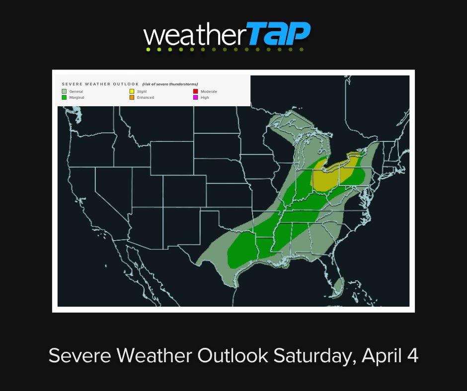
But don't let your guard down—this is just the start. The severe threat expands into the Plains tomorrow (with a slight risk) and Friday (with a marginal risk) but a much more significant setup is brewing for this weekend into next week. #severwx
English
0
0
0
36
weatherTAP
weatherTAP@weatherTAP·
Marginal Risk (Level 1/5) of severe wx for parts of Western/Central KS and SE FL. Main threats are severe wind gusts this afternoon. #KSwx #FLwx
weatherTAP tweet media
English
1
0
2
95
weatherTAP
weatherTAP@weatherTAP·
Day 3 of rain in FL continues with a Slight Risk of excessive rainfall for the eastern peninsula. I-95 corridor from Daytona Beach to Miami—esp near Treasure Coast—is at risk for localized flash flooding. Possibility of some storms with strong wind gusts this afternoon. #FLwx
English
0
0
0
169
weatherTAP
weatherTAP@weatherTAP·
The WPC has upgraded the Atlantic side of FL Peninsula to a SLIGHT RISK for excessive rainfall today. With saturated soil from yesterday's storms, localized flooding is a concern from Cape Canaveral to Miami. up to 3"+ rain in 3 hours possible. #FLwx
English
0
0
1
252
weatherTAP
weatherTAP@weatherTAP·
A Marginal Risk (Level 1/4) for excessive rainfall is in effect through Wed in FL. Today: Rates of 0.5"-3"+/hr & thunderstorms possible this PM in Central FL Tues: Shift to South FL & East Coast Wed: rain totals could increase along the East Coast #FLwx
English
0
0
0
137
weatherTAP
weatherTAP@weatherTAP·
The snow has ended, but the cold is just beginning. Lows will dip into the 20s/30s across the Northern Plains & Upper Midwest by Monday morning! A new clipper system arrives tomorrow, bringing gusty winds & more snow showers to the Great Lakes. #NDwx #MNwx #WIwx #MIwx
weatherTAP tweet media
English
0
0
0
207
weatherTAP
weatherTAP@weatherTAP·
A Marginal Risk for severe weather is in effect for the Carolinas/Mid-Atlantic this Easter Sunday. Isolated damaging winds are possible as a line of storms pushes through this afternoon into the evening (see HRRR loop below). #Easter #wx #NCwx #SCwx #MDwx @VAwx
English
0
0
0
221
weatherTAP
weatherTAP@weatherTAP·
Late-season winter storm continues in Upper Midwest & Great Lakes. Snow rates of 1-2"/hr in MN. Gusty winds & heavy snow could create near-whiteout conditions in ND, SD & MN. Dangerous icing (up to 0.5") for N WI & the U.P. Freezing rain until mid afternoon in MN, N WI and MI.
English
0
0
0
219
weatherTAP
weatherTAP@weatherTAP·
Heavy rain is also likely today across the ArkLaTex, the Lower Mississippi Valley, and parts of the Southern Great Lakes, bringing a slight risk of flash flooding to these regions. #rain #OHwx #MIwx #INwx #NYwx #PAwx
English
0
0
0
198
weatherTAP
weatherTAP@weatherTAP·
A Slight Risk is in effect for the Ohio Valley & Lower Great Lakes. The main threat is damaging wind gusts in the yellow area this afternoon through the early evening. There’s also a chance of thunderstorms in East TX, the lower MS Valley & the TN Valley. #severewx
weatherTAP tweet media
English
1
0
0
99
weatherTAP
weatherTAP@weatherTAP·
An Enhanced Risk (Level 3/5) of severe weather is in effect today for Northern MO, Southern IA, and NW Illinois. Main Threats: A few tornadoes, isolated very large hail, and damaging winds. Timing: Late afternoon & evening. Stay weather aware! #MOwx #IAwx #ILwx #severewx
weatherTAP tweet media
English
0
0
0
225
weatherTAP
weatherTAP@weatherTAP·
Our first late-season winter storm is finally tapering off. Totals over the last 24 hours: Snow: Richmond, MN- 5.0". Sleet: Wausau, WI -0.70". Ice: Knowlton, WI - 0.70" Travel remains treacherous this morning across the U.P. & northern WIn due to icy roads & broken limbs.
weatherTAP tweet media
English
0
0
0
99
weatherTAP
weatherTAP@weatherTAP·
Second system from Rockies into the Northern Plains Fri through Sat. Widespread 6"+ of snow for ND and SD, with over a foot possible locally. Additional icing will likely worsen power outage risks & tree damage. #NDwx #SDwx #MNwx #WIwx
weatherTAP tweet media
English
0
0
0
138
weatherTAP
weatherTAP@weatherTAP·
1 of 2 winter storms happening in Northern Plains & Great Lakes. Heavy Snow (3–6") for northern MN & eastern ND. Snowfall rates may hit 1"/hour. Significant icing (0.1" to 0.5") is expected from eastern SD to southern MN, central WI, and northern MI. Travel impacts expected.
English
1
0
0
135
weatherTAP
weatherTAP@weatherTAP·
An Enhanced Risk (Level 3/5) of severe thunderstorms is in effect for eastern Iowa, northern Illinois, and southern Wisconsin. Damaging wind gusts, large hail and a few tornadoes (some potentially strong) are possible. Stay weather aware today! #severewx #IAwx #ILwx #WIwx
weatherTAP tweet media
English
0
1
1
612
weatherTAP
weatherTAP@weatherTAP·
Tornado watches (yellow) are in effect in parts of TX, OK, KS & MO until late this evening (expiring 12:00 - 1:00 AM CST). Thunderstorm watches (pink) are in effect in central TXuntil 2:00 AM CST. If you are in these areas stay weather aware. #severewx #TXwx #OKwx #KSwx #MOwx
weatherTAP tweet media
English
0
1
2
517
weatherTAP
weatherTAP@weatherTAP·
An Enhanced Risk (Level 3/5) is in place today for parts of the Central/Southern Plains. Strong tornadoes, damaging winds, and large hail (2"+) possible. Stay weather-aware today! #severewx #TXwx #OKwx #NEwx #INwx #OHwx #PAwx #VAwx
weatherTAP tweet media
English
0
0
0
469
weatherTAP
weatherTAP@weatherTAP·
A late-season winter storm is set to bring heavy snow and disruptive ice to the Northern Plains and Great Lakes through Friday. 3-6"+ snow likely for the Dakotas & N. MN. ⚠️ Hazardous ice accumulation (0.10"-0.25"+) for S. MN, WI, and N. MI. #WinterStorm #AprilSnow #IceStorm
weatherTAP tweet media
English
0
0
0
60
weatherTAP
weatherTAP@weatherTAP·
A Slight Risk (Level 2/5) is in effect today from the Mid-MS Valley through the Ohio Valley & Great Lakes, plus western OK/TX. Primary threats: Damaging wind gusts & large hail. #severewx
weatherTAP tweet media
English
1
0
0
61