Tony
8K posts
Tony
@whatdoweseehere
** Find me on BlueSky** Meteorologist in DC! I work for the WPC (NOAA-NWS) (formerly HPC) but this is my personal account. CT native. Cornell/SUNY-ALB.
Washington, DC Katılım Ağustos 2009
553 Takip Edilen1K Takipçiler
Tony retweetledi

@therobdale @wxmvpete Thanks for keeping tabs on things. End-of-season review will inform our summer work.
English
@wxmvpete @whatdoweseehere Good to hear - I'm glad some projects have social science considered.
English
@therobdale This isn’t done in a vacuum. The NBM had issues so it was reverted. Trouble is that elsewhere it was doing fine. It’s unfortunate.
English
@whatdoweseehere It disappoints me that WPC does all this tweaking without working alongside social scientists first. After the initial rollout this winter when I talked to your leadership they took WSE out and it did pretty well.
Unsure why it reappeared...
English
@therobdale @NWSWPC @NWS All high-end potential storms have big ranges… but that’s at conflict with public perception of skill. Is there a limit to an acceptable range per social science? Maybe?
English
@therobdale It’s been WSE background since December. Waiting on next NBM version.
English
@whatdoweseehere Yup. For some reason it looks like the WSE came back.
I hoped it was a temporary glitch but it’s been going on for a bit now.
English
@capitalweather Interesting gradient across DC proper itself. Such marginal temperatures!
English
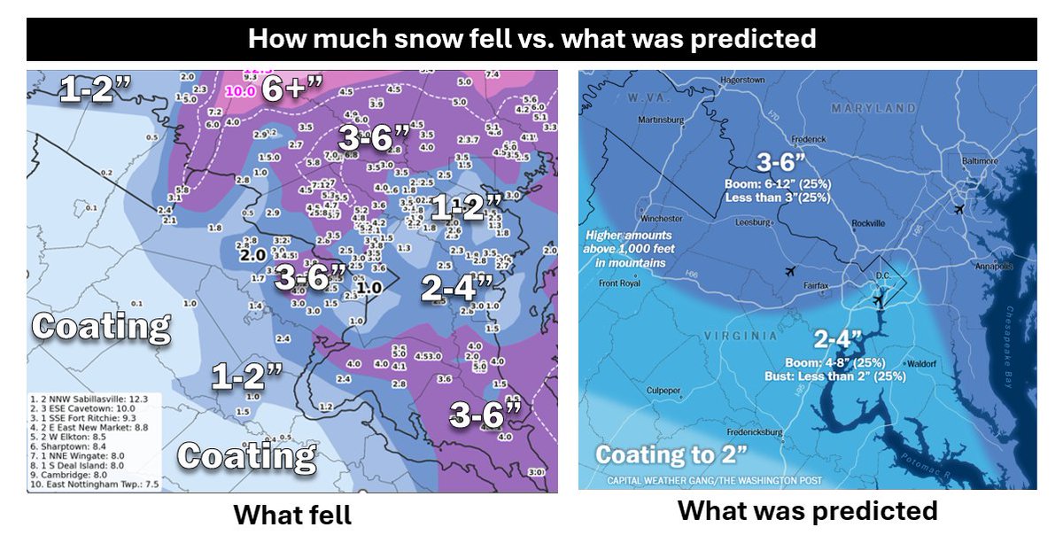
Snow forecast review: What fell vs. what we predicted
This was one of the toughest storms to forecast in 20+ years for D.C. area. Why?
• Temps were marginal — 1–2° made a big difference
• D.C. sat near the edge of the heaviest precip
• Small-scale features (like a Norlun trough) shifted totals over just a few miles
Models struggled. Three days out: anywhere from no snow to 3 feet. Even hours before onset: under 1" to 10".
Our final call captured the sharp gradient and timing well in many areas. Some neighborhoods matched closely. Others were a bust.
Where we missed — west/southwest of Fairfax and parts of downtown & east.
Why? the storm tracked ~20–30 miles farther east and intensified more slowly, shifting heavier bands and widening the dry slot.
We emphasized uncertainty throughout, and this storm proved why.
Imperfect — but in a volatile setup, we believe our forecast rose to the challenge.
English
GeMPak is looking really good right now
0x45@0x45o
not a color expert here but how can you not have the capacity to support more than two colors?
English
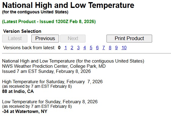
@TomNiziol @NWSBUFFALO -36.7°C —> -34°F (pending 18Z 2 group)
METAR KART 081156Z AUTO 21003KT 10SM CLR M37/ A3036 RMK AO2 SLP302 I6000 T1367 11317 21367 53017 $
Polski

Looks like Watertown NY takes the prize for the national low temperature overnight. They bottomed out at -34.6°F. NOAA rounded to -34°F. #frigid @NWSBUFFALO

English