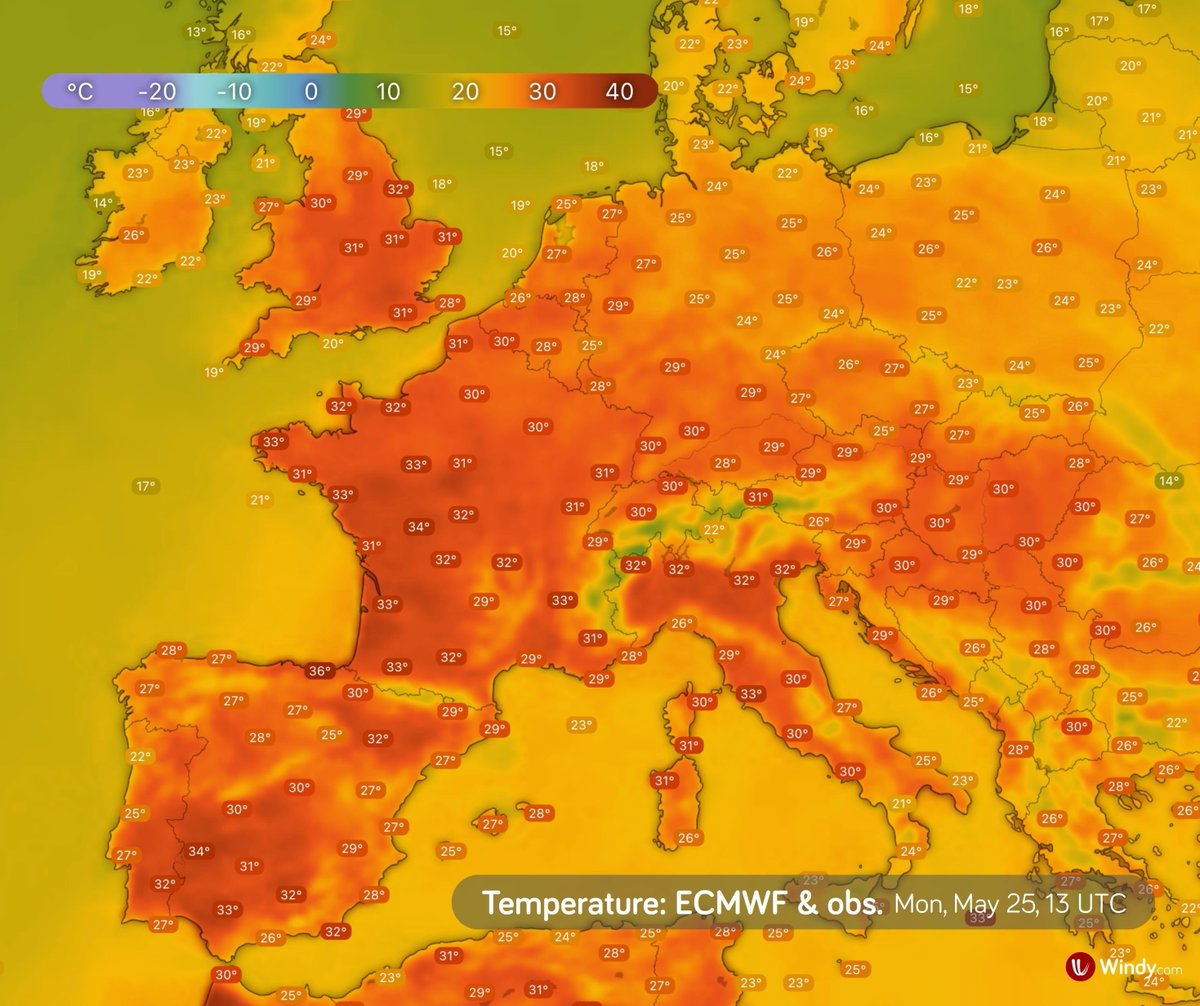
Windy.com

10.5K posts

Windy.com banner
Windy.com

Windy.com

@Windycom

🛰️🌎 Windy is an extraordinary tool for #weather #forecast visualization. It's fast, intuitive, detailed & most accurate #app trusted by #professionals

Prague Katılım Kasım 2014
2.9K Takip Edilen71.5K Takipçiler
Sabitlenmiş Tweet
Windy.com
Windy.com@Windycom·
🌪️ Cyclone Narelle (34U) Narelle is intensifying and could make landfall in Cape York Peninsula (🇦🇺 Australia) on Friday. 📍 790 km ENE of Willis Island 💨 85 km/h (gusts 120 km/h) ➡️ Moving WSW at 16 km/h
English
2
2
25
4K
Windy.com
Windy.com@Windycom·
Narelle will move back over the Indian Ocean on Tuesday evening and may re-intensify over warm waters. Even if its centre stays offshore, it could still bring very strong winds to parts of the Pilbara coast. Some scenarios suggest it may return over land this weekend.
English
0
0
1
781
Windy.com
Windy.com@Windycom·
For the northern Kimberley coast, heavy rainfall is possible on Monday and Tuesday, with local totals of 100-140 mm, potentially leading to moderate flooding. Wind gusts may reach around 90 km/h. Follow the latest forecasts and advice from local authorities. ⚠️
English
1
0
1
848
Windy.com
Windy.com@Windycom·
🌀 Tropical system Narelle has struck the Australian mainland for the third time. Narelle moved over northern Kimberley in Western Australia on Monday afternoon and is expected to remain there through Tuesday before moving back over the Indian Ocean. More in thread.
English
2
2
15
1.6K
Windy.com
Windy.com@Windycom·
Narelle may move over the Gulf of Carpentaria late Friday night into Saturday and re-intensify into a Category 3 cyclone. On Sunday, it is forecast to cross the Top End, bringing gusts up to 160 km/h and 100–200 mm of rain. Flooding is ongoing.
English
0
0
5
902
Windy.com
Windy.com@Windycom·
🌀 Tropical Cyclone Narelle crossed the Cape York Peninsula after making landfall on Thursday as a Category 4 system, according to the BoM, and is now moving west. Follow the latest warnings and advice from local emergency services. ⚠️
English
2
5
17
1.9K
Windy.com
Windy.com@Windycom·
In many places, daily and even monthly March temperature records may be broken. Highs may reach the 80s and 90s °F, with some areas in the Desert Southwest exceeding 100 °F. Some locations may even record their earliest-ever 100 °F temperature.
English
0
1
3
673
Windy.com
Windy.com@Windycom·
The hottest conditions are expected on Friday and Saturday across the Southwest. After that, the heat should ease somewhat, but temperatures will likely remain above average across many parts of the country.
English
1
0
4
797
Windy.com
Windy.com@Windycom·
🌡️ An unusually early heat wave is affecting the southwestern US. On Tuesday, the highest temperature reached 104 °F in Indio, California, according to NOAA estimates. The heat wave is expected to intensify and expand eastward. ⚠️ High temperatures may pose health risks.
English
2
7
22
2.2K
Windy.com
Windy.com@Windycom·
Juraj climbs mountains, flies off them, sleeps in -20°, and somehow still finds time for a Tinder date, on a paraglide. 🪂 Full interview is out now on YouTube 🔗 youtu.be/g6WxfqpjYQk
YouTube video
YouTube
English
0
0
8
1.4K
Windy.com
Windy.com@Windycom·
Much colder Arctic air will follow behind the storm, making Tuesday feel more like January than mid-March. In contrast, parts of the western U.S., especially the Southwest, could see well above-average and even locally record-breaking heat.
English
0
0
6
1.2K
Windy.com
Windy.com@Windycom·
Blizzard conditions are expected across parts of northern Michigan and eastern Wisconsin: • 12–24 inches (30–60 cm) of snow, locally up to 30 inches (75 cm) • wind gusts over 50 mph (80 km/h), with whiteout conditions possible 🌬️
English
1
1
6
1.3K
Windy.com
Windy.com@Windycom·
❄️ A powerful low-pressure system will bring heavy snow from the Great Lakes to the northeastern U.S. late this week and early next week, followed by a surge of Arctic air across the eastern half of the country. ⚠️ More in the thread.
English
3
5
32
5.4K
Windy.com
Windy.com@Windycom·
Thursday: Thunderstorm activity will continue moving eastward into the southeastern United States.
English
0
0
3
795
Windy.com
Windy.com@Windycom·
Wednesday: The severe weather threat will shift from ArkLaTex and the Lower Mississippi Valley northeastward through the Ohio Valley into the Mid-Atlantic. Farther south, a line of storms is expected over ArkLaTex.
English
1
0
5
1.1K
Windy.com
Windy.com@Windycom·
⛈️ A severe thunderstorm threat will persist across the central, southern, and eastern U.S. through Thursday. Storms may bring heavy rain and flash flooding, large hail, damaging winds up to 60–70 mph, and possible tornadoes. ⚠️ Follow official forecasts and local guidance.
Windy.com tweet mediaWindy.com tweet mediaWindy.com tweet mediaWindy.com tweet media
English
1
1
21
2.1K
Windy.com
Windy.com@Windycom·
🌧️ Flooding continues in northern & northeastern Australia. Rivers in the Northern Territory and Queensland remain flooded. North: More showers and storms may bring heavy rain. Rivers may keep rising. Eastern Queensland: Rain will ease, but river levels may stay high for days. ⚠️
English
2
5
41
5.4K
Windy.com
Windy.com@Windycom·
Possible impacts include: • road closures • power outages • infrastructure damage • temporary community isolation
English
0
0
3
1.1K
Windy.com
Windy.com@Windycom·
🌧️ Flood risk is increasing across northern Australia, especially in the Northern Territory and Queensland. Some rivers are already in flood. Expected weekend rainfall: 50–150 mm, locally >200 mm. River and flash flooding are possible. Follow forecasts and local advice. ⚠️
Windy.com tweet mediaWindy.com tweet mediaWindy.com tweet mediaWindy.com tweet media
English
4
1
19
129.5K