Brian Alonzo

33.7K posts

Brian Alonzo banner
Brian Alonzo

Brian Alonzo

@wxprobrian

Chief Meteorologist for @cpsenergy. Former TV meteorologist in Victoria, Tyler, & San Antonio, Texas. My tweets/retweets are mine & not that of my employer.

San Antonio, TX Katılım Ağustos 2008
2K Takip Edilen3.3K Takipçiler
Brian Alonzo
Brian Alonzo@wxprobrian·
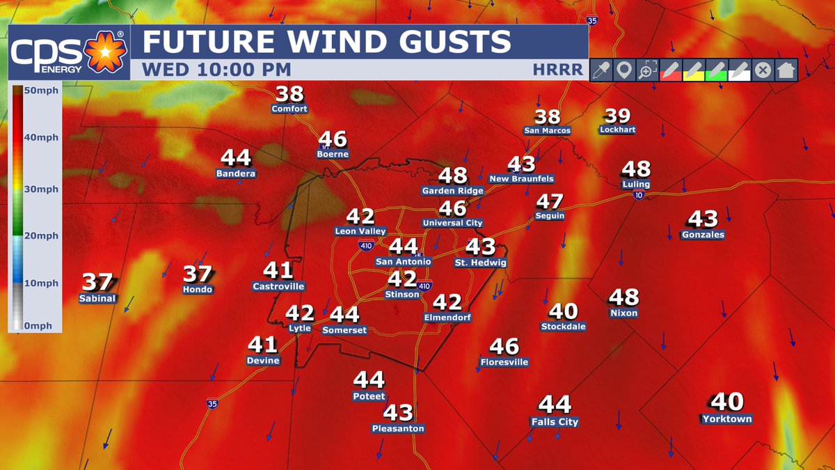
SAT 6:53AM: There is some areas of spotty showers and/or sprinkles out there this morning. Not everyone will see precipitation today. This is expected to linger this morning. Clouds breaks are possible later this afternoon.
English
0
0
2
76
Brian Alonzo
Brian Alonzo@wxprobrian·
6:30PM: Cold front now arriving in San Antonio. Winds are beginning to increase in northern Bexar county. Expect winds to increase and temperatures to get cooler.
English
0
0
3
143
Brian Alonzo
Brian Alonzo@wxprobrian·
ARE YOU READY? Cold front arrives around 5-6pm in the San Antonio area. This will increase the winds tonight and overnight. Gusts up to 40 mph possible. Expect cooler temps mainly on Saturday. A sprinkle possible too. Temps warm back up on Sunday.
Brian Alonzo tweet mediaBrian Alonzo tweet mediaBrian Alonzo tweet media
English
0
1
0
141
Brian Alonzo
Brian Alonzo@wxprobrian·
WEEKLY FORECAST: March 23, 2026.
English
0
2
5
631
Brian Alonzo
Brian Alonzo@wxprobrian·
THIS WEEKEND: Today is the first day of Spring. It won't feel like it this weekend. Hot temps are on the menu. Tomorrow I'm forecasting 94° which would tie the record. On Sunday, there is a high to extreme fire danger. Take precautions to prevent any wildfires from starting.
Brian Alonzo tweet mediaBrian Alonzo tweet mediaBrian Alonzo tweet media
English
0
0
1
132
Brian Alonzo
Brian Alonzo@wxprobrian·
DUST: I noticed the West Texas dust in the sky this evening after the front came through.
Brian Alonzo tweet media
English
0
0
3
122
Brian Alonzo
Brian Alonzo@wxprobrian·
NEW RECORD: We officially hit a record high of 98° in San Antonio this afternoon. This front caused compressional heating where air sinks, compresses and heats up ahead of a front.
Brian Alonzo tweet media
English
0
3
18
1.6K
Brian Alonzo
Brian Alonzo@wxprobrian·
6:47PM: A 47 mph wind gust was observed at San Antonio Int'l Airport.
English
0
0
2
289
Brian Alonzo
Brian Alonzo@wxprobrian·
BRACE FOR IMPACT: Cold front now arriving in San Antonio. Expect winds and wind gusts to increase the rest of the evening.
English
0
0
5
270
Brian Alonzo
Brian Alonzo@wxprobrian·
SUNDAY 4PM: In San Antonio, we have officially reached 93°. This breaks the old record of 91° set back in 1908. We still could go higher the next hour or so. Temps in the 40s in the panhandle and mid to upper 90s along parts of the Texas/Mexico border
Brian Alonzo tweet media
English
0
1
2
217
Brian Alonzo
Brian Alonzo@wxprobrian·
BE ALERT: As the front get closer to our area, skies will get a little hazy the rest of the afternoon and this evening. The winds are bringing dust from West Texas. San Angelo is reporting blowing dust. This may affect those with breathing issues or allergies.
English
1
1
2
420
Brian Alonzo
Brian Alonzo@wxprobrian·
ARE YOU READY? Humongous changes are on the way. A Red Flag Warning goes into effect at noon. A strong cold front arrives around sunset. I'm expecting a record high of 95° (could be a bit higher). then wind gusts up to 50 mph, possibly 60 mph late tonight. Colder Monday morning.
Brian Alonzo tweet mediaBrian Alonzo tweet mediaBrian Alonzo tweet mediaBrian Alonzo tweet media
English
1
0
3
242
Brian Alonzo
Brian Alonzo@wxprobrian·
GET READY: More changes are on the way. Unfornately, it will be dry through all of next week. On Sunday, the record is likely to be broken before a front arrives. This front will be strong, bringing cooler temps and windy conditions. Gusts Sunday night could be up to 50 mph.
Brian Alonzo tweet media
English
0
0
1
116
Brian Alonzo
Brian Alonzo@wxprobrian·
TONIGHT: It's been windy today but winds are expected to get stronger this evening. Wind gusts to near 40 mph with isolated locations up to 50 mph. Sustained winds 15-25 mph. This will put wind chills in the upper 30s for Thursday morning. You'll need the jackets in the morning.
Brian Alonzo tweet mediaBrian Alonzo tweet media
English
1
0
2
127
Brian Alonzo
Brian Alonzo@wxprobrian·
6:17AM: Moderate to heavy rain & storms moving away from San Antonio. Flood Advisory in effect for Bexar Co. until 8am. Some light precip. remains for the next 1-2 hours. Later this morning clouds will break up giving us a mostly sunny to partly cloudy day. Highs in the mid 80s.
English
0
1
4
529
Brian Alonzo
Brian Alonzo@wxprobrian·
8:45PM: The storm north of San Antonio is putting on a good lightning show.
English
1
1
4
215
Brian Alonzo
Brian Alonzo@wxprobrian·
8:23PM: Severe Thunderstorm Watch was issued for counties north of Bexar county and along I-35. Tornado Watch remains west of San Antonio until 10pm. New line of strong to severe storms is developing west of Del Rio. This line is what we need to watch for in the SA area overnight
English
0
0
1
260
Brian Alonzo
Brian Alonzo@wxprobrian·
7:06PM: Tracking a strong severe storm over Leakey. It has had a history of producing a tornado near Del Rio. Hail over 3" in diameter was reported in Camp Wood. This is moving closer to Bexar county. If you live in NW parts of Bexar Co., you need to monitor closely.
English
1
4
15
866
Brian Alonzo
Brian Alonzo@wxprobrian·
6:10PM: A new Tornado Warning was issued for parts of Uvalde, Real, and Kinney counties. I highlighted (in white) what's called a 3 Body Scatter Spike. This tells me large hail is in this storm. Spinning shear marker indicating rotation is still occurring in this storm.
English
0
2
5
204
Brian Alonzo
Brian Alonzo@wxprobrian·
5:54PM: Watching this storm closely north of Bracketville. A confirmed tornado is on the ground. This tornado is moving east at 40 mph. This storm also has the capability of dropping baseball size hail.
English
0
0
3
239