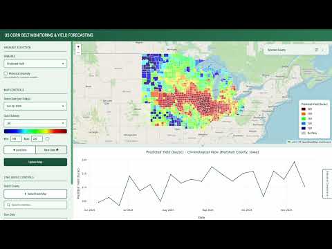
Yichen Yang

5 posts

Yichen Yang

Yichen Yang

@yichenyang_geo

Climate scientist tracking urban heat with bicycles & satellites. PhD @Yale. Turning satellite data into solutions.

Katılım Şubat 2026
71 Takip Edilen0 Takipçiler
Yichen Yang
Yichen Yang@yichenyang_geo·
Built a corn intelligence system and am releasing it publicly before moving to my next research phase. What it is: (1) County level vegetation indices, weather data, soil data, and drought data for monitoring corn growth conditions, updated every 8 days since 2001. All are proven impactors to corn yield. Plus county level yield forecasts for the top 12 US Corn Belt states. Uses peer reviewed machine learning methods. County level MAE: 12 bu/acre. Validated over the last 11 years. Dashboard: lnkd.in/g45gwGEY Use case: time evolution of county-level corn yield forecast of 2024 youtube.com/watch?v=AFnILb… (2) National corn yield forecasts since 2015. Consistently closer to final yield numbers than USDA's own July and August forecasts. Validated over the last 11 years. Dashboard: lnkd.in/gqkx9d9q Both are live now. 2026 forecasts begin in early May. Why this exists: Commodity traders have proprietary satellite forecast models. Farmers and regional co-ops have more limited access to this type of intelligence. This information asymmetry is expensive. I'm publishing these forecasts as a public good to narrow that gap. Also: academic yield forecasting methods get published in journals and are rarely tested in operational settings. This is that test. Real data, real season, updated in real time. How to use it: Treat these as a second signal alongside USDA and other sources. Don't use forecasts in isolation. The county level monitoring data (vegetation indices, soil moisture, weather anomalies) is there to support you. Use it to understand what's driving the numbers. What I need from you: If you find this useful, tell me how to make it more useful. GitHub issues and discussions are open: lnkd.in/gQxQR8vq About me: yichenyang.dev #AgTech #Agriculture #MachineLearning #RemoteSensing #OpenData #GeoSpatial #CornBelt #CommodityTrading #OpenScience #DataScience
YouTube video
YouTube
Yichen Yang tweet media
English
2
0
0
41
Yichen Yang
Yichen Yang@yichenyang_geo·
This is Google being Google. Not vaporware, real infrastructure that saves lives. This pairs beautifully with Akinboyewa et al. (2024) who used large multimodal model to estimate floodwater depth from on-site photos: link.springer.com/article/10.100…. Humanity poured hundreds of billions into foundation models, and now those models are auto-filling ground truth gaps that sensors rarely reached.
Google Research@GoogleResearch

Flash flood prediction models need historical data and model training that often doesn't exist. Our solution: Groundsource, a new AI-powered methodology that uses Gemini to transform 5M+ global reports into a precise dataset of 2.6M+ flood events. This provides a massive, open-source benchmark, scaling impact — especially in regions like Africa and Southeast Asia that lacked data. The same technique could be applied to other natural disasters. Read the technical breakdown on the Research Blog: goo.gle/46VcQbh

English
0
0
0
24
Yichen Yang
Yichen Yang@yichenyang_geo·
I have a theory that AI chat is teaching us all the same vocabulary. Everyone online now says: “Actionable insights” (how actionable?) “Domain expertise” (is there actually an expert here?) “Vertical” (just say industry) “Game changer” (do you even know how the old game was played?) Apologies for the sarcasm but these words create a weird hollowness. Now when I browse a startup website and see “actionable insights,” I feel intellectually insulted. Buzzwords, and especially the buzzwords that are AI centralized, makes everything feel less genuine, and harder to know what’s real. I’m sure there are more I haven’t mentioned. Share your thoughts on what words got popular specifically because of AI. Are they worth the criticism? Curious if I’m onto something.
English
1
0
0
21
Qiusheng Wu
Qiusheng Wu@giswqs·
I’m thrilled to share that my new book (Spatial Data Management with DuckDB) is now published! 🎉 At 430 pages, this book provides a practical, hands-on guide to scalable geospatial analytics and visualization using DuckDB. All code examples are open-source and freely available on GitHub so you can follow along, adapt, and extend them. Book website: duckdb.gishub.org GitHub repo: github.com/giswqs/duckdb-… Table of Contents: books.gishub.org/duckdb/book-to… The PDF edition of the book is available on @leanpub: leanpub.com/duckdb Full-color print edition will be available on Amazon soon. Stay tuned. #geospatial #duckdb #python #leafmap #datascience
Qiusheng Wu tweet media
English
15
92
514
27.4K