REMAMETEO 🌸🌸🌤️🌤️ retweetou

📌 Mañana @AEMET_Esp activa avisos amarillos 🟨por #lluvias ☔️y #tormentas ⚡️ en toda la provincia de #Huelva y en comarcas de #Sevilla y #Cádiz
Extrema la #precaución

Español
REMAMETEO 🌸🌸🌤️🌤️
28.5K posts


@RemaMeteo
La #meteo con las mejores info,predicciones,fotos,seguimiento, etc de nuestros AFICIONADOS, LOS PRO del país y... más allá.

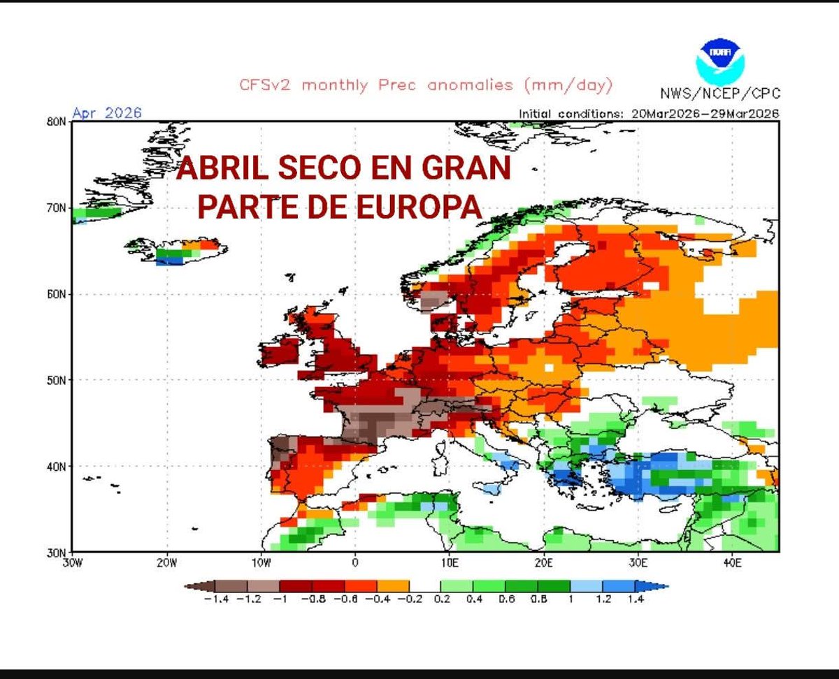
Tela!!! com estan sortint els models per la setmana vinent, toca seguiment del bo. #meteo
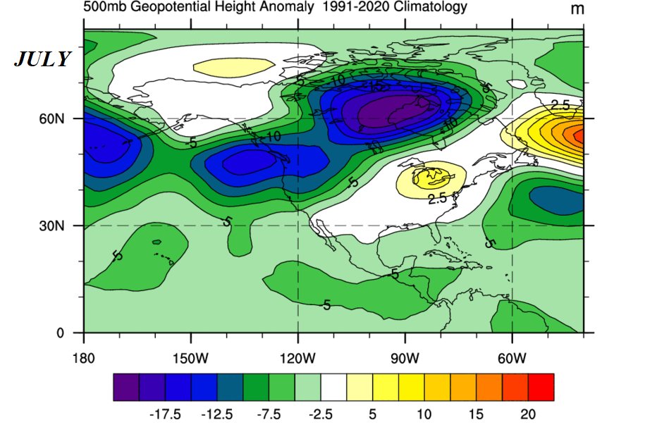
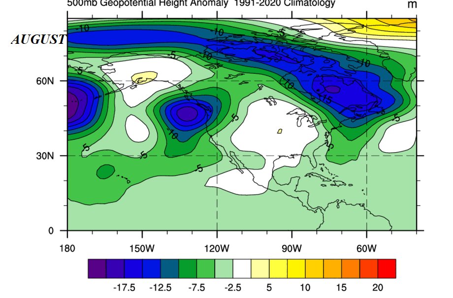
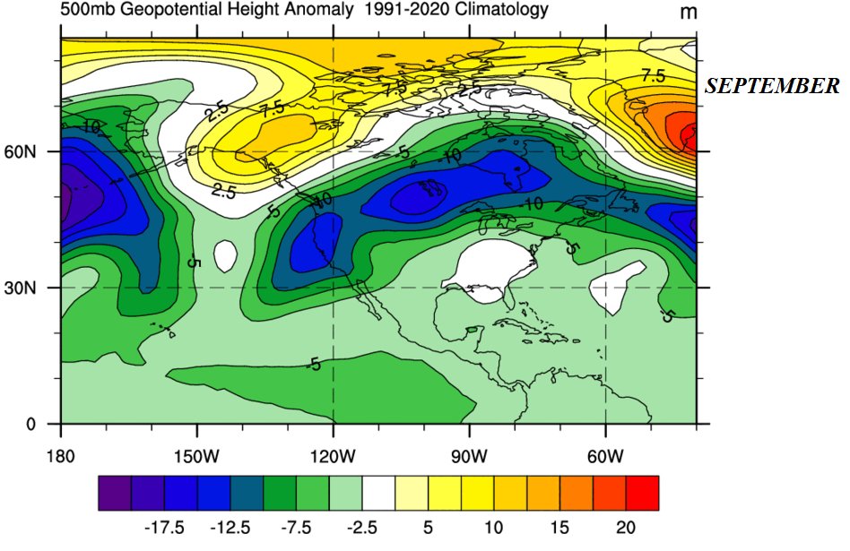
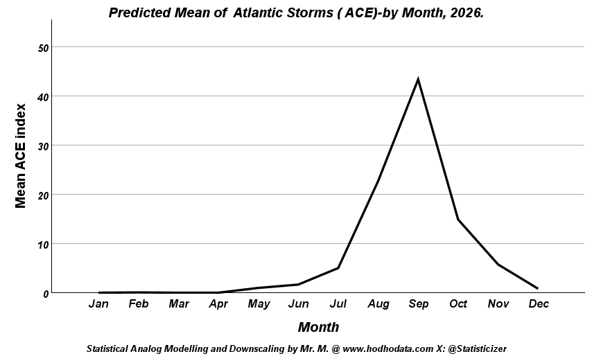
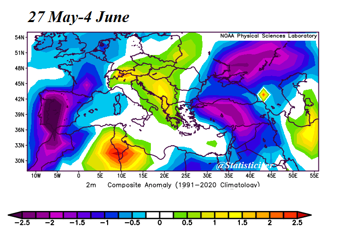
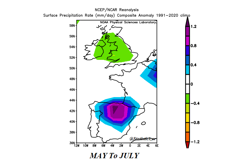
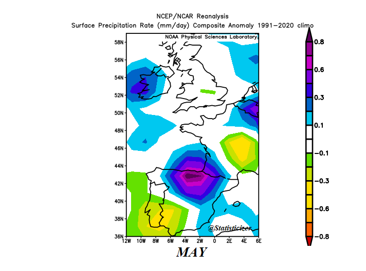
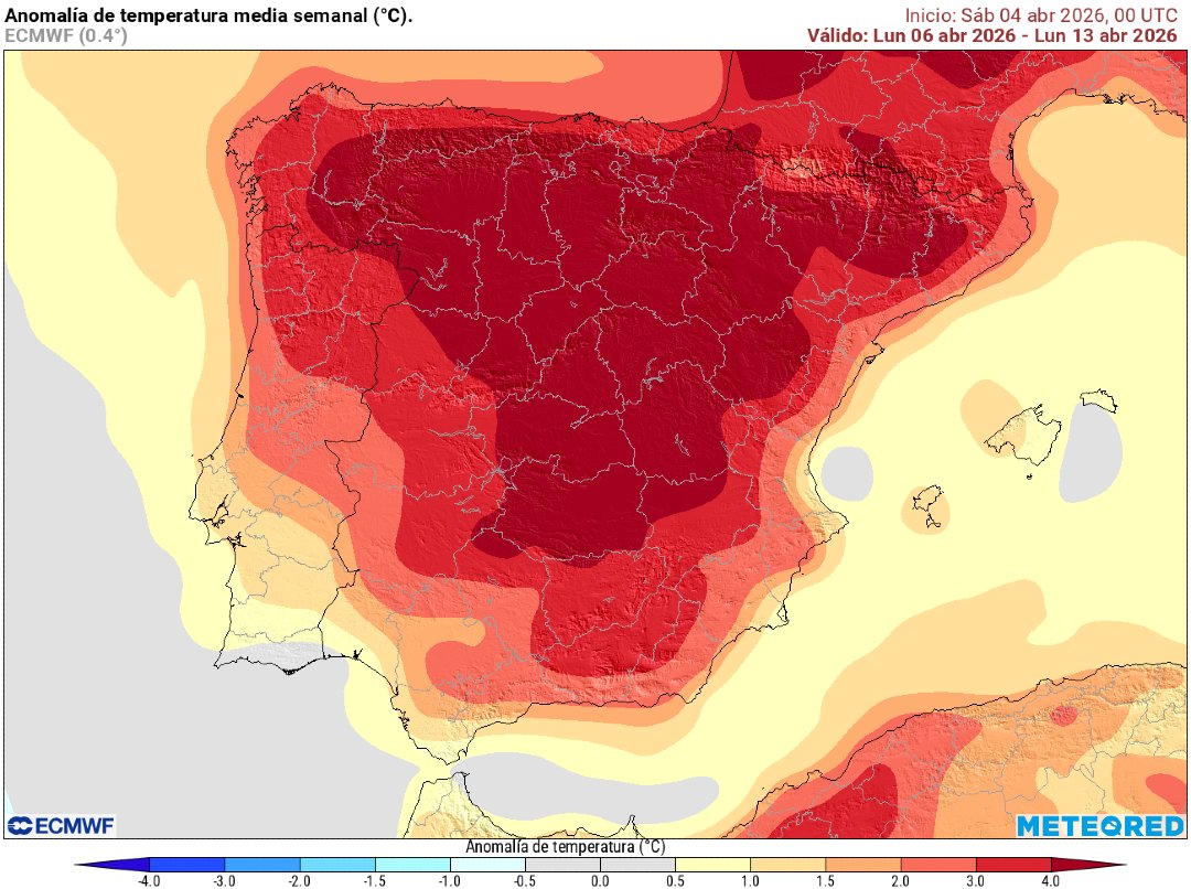
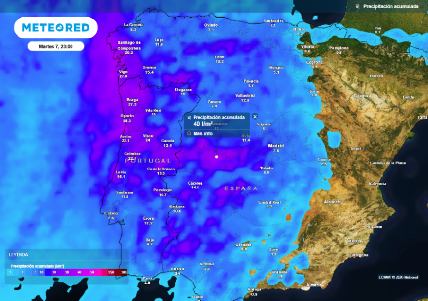
⚡️🌍 #Iberia #NorthAfrica | Early Signal: Summer Rainfall Persistence & Flood Risk Outlook (May–August). A consistent analog-based rainfall signal is emerging across northern Iberia during summer 2026, with notable persistence from May through August, supported by multi-month composites and seasonal aggregation (May–July). 📊 What the signal shows 🔵 Persistent wet core: Northern Spain (Cantabrian range / Ebro-adjacent zones) shows a recurrent rainfall anomaly center across all months. 🟣 Deep purple anomalies: These indicate high-end rainfall departures, suggestive of: Repeated convective episodes Potential mesoscale clustering Elevated probability of extreme precipitation events 🔄 Spatial evolution through summer: May → June: Core consolidates over north-central Spain July: Tight, intense anomaly persists August: Expansion northeastward into southern France and adjacent regions. 🌐 Secondary extensions: Western Iberia (Portugal) intermittently affected Southern France increasingly involved mid–late summer ⚠️ Interpretation: This is not a transient signal. It reflects a structured seasonal imprint, likely tied to: Recurrent upper-level trough positioning / cut-off lows Enhanced moisture recycling and Atlantic inflow Possible interaction with AAM / ENSO-modulated circulation states 👉 The month-to-month persistence significantly increases the risk of: Soil saturation accumulation River basin stress Flash flood potential during convective peaks 🚨 Early Warning Perspective If this signal verifies: Northern Spain = primary Floods hotspot France (southwest) = secondary expansion zone ( June & August) Risk window may initiate early (May) and persist into late summer This raises concern for: Ebro basin Cantabrian rivers Cross-border hydrological response into SW France 🧠 Methodology (brief) Multi-analog ensemble (season-matching years) NCEP/NCAR reanalysis composites 1991–2020 climatological baseline anomalies Spatial-temporal consistency filtering across months 📌 Bottom line A rare level of persistence in rainfall anomalies is being flagged across Iberia. Not just isolated events—but a seasonal tendency toward repeated wet episodes, with localized extremes. Further model alignment will determine magnitude—but the signal is already coherent enough to monitor closely. During summer I will be posting 2-weekly outlooks for hot spots that may emerge temportally within months. Kindly share ♻️ and mention people who may be concerned. Early warning saves lives and property. Statistical Analog Modelling & Downscaling By Mr. M @Statisticizer / hodhodata.com .


⚠️INCIDENCIAS DOMINGO DE RAMOS (A LAS 21:10, TODAVÍA ES CAPAZ DE PASAR ALGO MÁS) -Borriquita: Incendio en la calle Cuna lo que le ha obligado a desviar el recorrido por Tetuán -La Cena: Desvanecimiento del director espiritual en plena calle Sierpes Sigue🔜