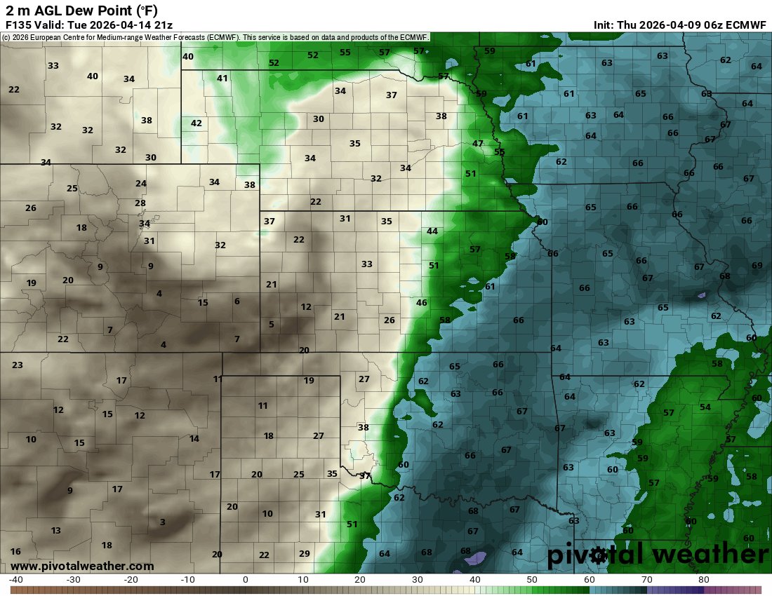
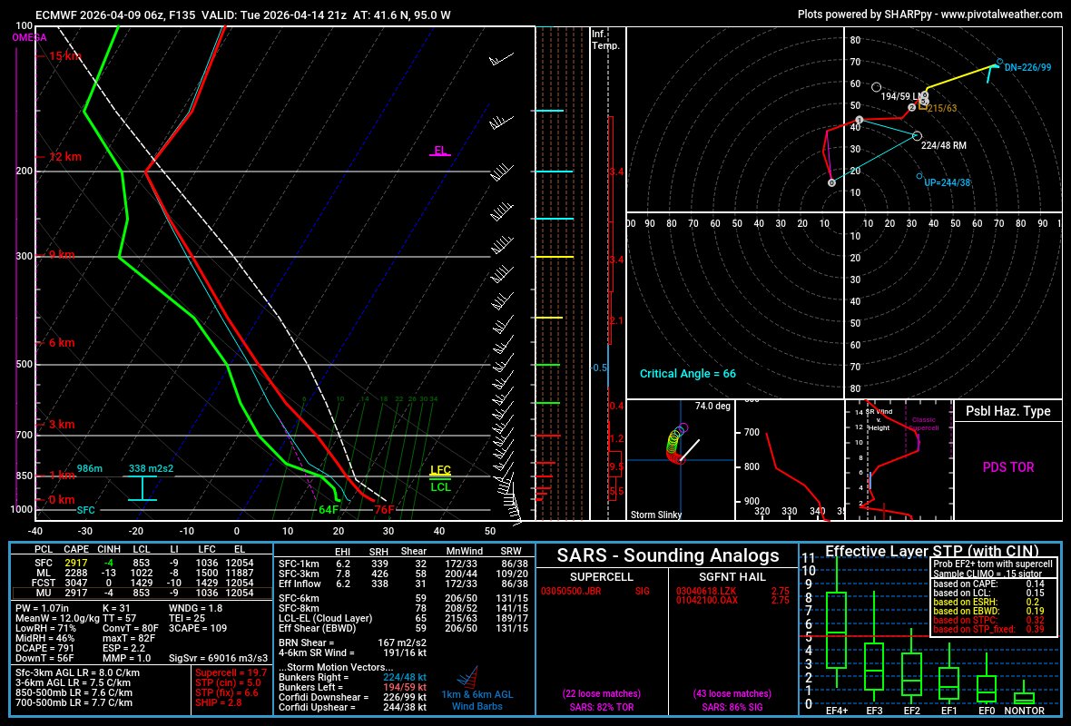
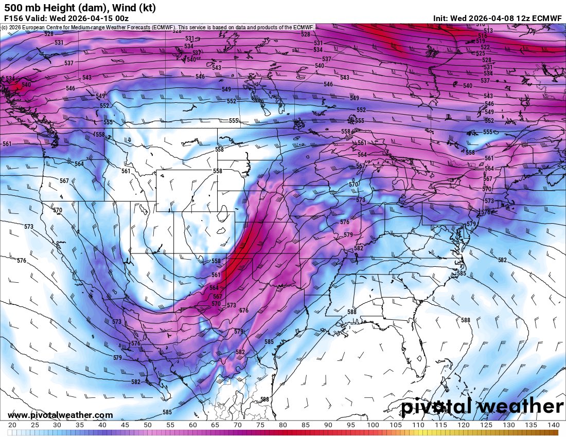
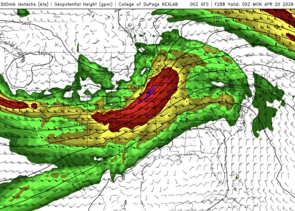
Bryce_WX

41.1K posts

Bryce_WX banner
Bryce_WX

Bryce_WX

@369Hurricane

19 | Passion in sports and weather

Your moms house Присоединился Temmuz 2020
958 Подписки780 Подписчики
Bryce_WX ретвитнул
TornadoClips
TornadoClips@TornadoClipss·
Incredible FOUND footage of the May 3 1999 F5 tornado near Newcastle
English
0
5
29
664
Bryce_WX ретвитнул
Jaydon Shaw
Jaydon Shaw@JaydonShawwx·
Crazy look along the dryline for Tuesday on the GFS
Jaydon Shaw tweet mediaJaydon Shaw tweet mediaJaydon Shaw tweet mediaJaydon Shaw tweet media
English
3
7
55
1.4K
Bryce_WX ретвитнул
Nick Krasznavolgyi
Nick Krasznavolgyi@NickKrasz_Wx·
On this day in 2011: A cyclic supercell produced multiple intense tornadoes, including a narrow yet violent EF4 west of Pocahontas, Iowa. A farmstead was completely obliterated, and a 30,000-pound combine was thrown more than 50 meters into a nearby field. The site it originated from exhibited extreme damage, though the official rating was 170 mph. In my view, the intensity at that location was likely stronger, arguably consistent with potentially EF5 damage based on the same contextual reasoning used in the Enderlin upgrade, the paper mentions a combine being thrown or tossed more than 50 meters indicates EF5 winds over 200 mph. This was also not likely a satellite tornado, but had its own mesocyclone.
Nick Krasznavolgyi tweet mediaNick Krasznavolgyi tweet mediaNick Krasznavolgyi tweet mediaNick Krasznavolgyi tweet media
English
2
15
112
2.7K
Bryce_WX ретвитнул
Tyler
Tyler@tydeanwx·
Oh euro you're absolutely cooking for Tuesday. Sounding in western iowa
Tyler tweet mediaTyler tweet mediaTyler tweet mediaTyler tweet media
English
1
3
111
4.2K
Bryce_WX ретвитнул
JonasWX
JonasWX@JonasWX23·
Lol, only if… 1: Yellow - enhanced flow, black - enhanced flow with most favorable directional shear 2: Blue - front, black - area to watch for discrete development (mostly-perpendicular to front) SE IA would be a storm chaser’s dream if this were the case on Tuesday night 🤣
JonasWX tweet mediaJonasWX tweet media
English
1
5
75
6.7K
Bryce_WX ретвитнул
Sekai Chandra
Sekai Chandra@Sekai_WX·
The Union City, MI EF3 was not the first major Michigan tornado to weaponize unrestricted water-aided inflow. An even stronger (likely F5 IMO) tornado did the same in May 1964. Hitting the lakeside town of Chesterfield, this tornado swept away many homes and debarked trees entirely. However, the tornado didn't become notable until water opened up to its south, as evidenced by aerial imagery. No other notable tornadoes occurred on this day, and the tornado was either heavily weakened or dissipated by the time it made landfall again.
Sekai Chandra tweet mediaSekai Chandra tweet mediaSekai Chandra tweet mediaSekai Chandra tweet media
English
5
12
142
11.4K
Bryce_WX ретвитнул
Western_Kansas_Wx
Western_Kansas_Wx@300MphEF5·
Ground scar visible from an EF1 tornado the day after the 2007 Greensburg, KS EF5 on Google Earth. This tornado passed 1.3 miles west/southwest of the destroyed town during the outbreak on May 5th, and was seen by NWS surveyors performing a damage assessment on the EF5 tornado.
Western_Kansas_Wx tweet mediaWestern_Kansas_Wx tweet mediaWestern_Kansas_Wx tweet media
English
2
5
56
2.3K
Bryce_WX ретвитнул
SRRadarLoops
SRRadarLoops@LoopsSr·
EURO solutions have a potential higher end day on the 14th
SRRadarLoops tweet mediaSRRadarLoops tweet media
English
4
11
158
9.5K
Bryce_WX ретвитнул
Saheb Singh
Saheb Singh@PlaysSaheb·
The Grand Harbour of Malta tornado was initially a tornadic waterspout which made landfall as one of the deadliest in Europe and globally with est. 600 fatalities (deadliest waterspout on record), many by capsizing boats/armada. F3/T7 tornado. Date varies to 9/23/1551 or 1556.
Saheb Singh tweet mediaSaheb Singh tweet media
English
0
1
6
221
Bryce_WX ретвитнул
Skies Of The UK
Skies Of The UK@SkiesOfTheUK·
A potentially historic severe weather outbreak is looming for southern and central China in less than 15 hours. Latest GFS data reveals a textbook "loaded gun" setup across Guizhou and Hunan, featuring extreme parameters including SBCAPE over 3,500 J/kg, 3km EHI values pushing 15, and Significant Tornado Parameters between 7.0 and 9.4. This highly volatile environment is primed for violent, long-track tornadoes and giant hail if discrete supercells form. Even if rapid storm consolidation occurs, the resulting squall line would pose a massive destructive wind and flash flooding threat driven by precipitable water values exceeding two inches. Meteorologists and locals must monitor this incredibly dangerous situation immediately. #ChinaWeather #SevereWeather #Tornado #WXTwitter
Skies Of The UK tweet mediaSkies Of The UK tweet mediaSkies Of The UK tweet media
English
6
30
186
45K
Bryce_WX ретвитнул
Tyler
Tyler@tydeanwx·
Sunday-tuesday probably looks the best it has on the 06z GFS. Specifically monday and tuesday. Wowza. Top is monday bottom is tuesday. Will it stay? #wxtwitter
Tyler tweet mediaTyler tweet mediaTyler tweet mediaTyler tweet media
English
5
8
109
6.2K
Bryce_WX ретвитнул
SamWx
SamWx@Sam362899039981·
I guess bro
SamWx tweet mediaSamWx tweet mediaSamWx tweet mediaSamWx tweet media
English
4
8
124
8.4K
Bryce_WX ретвитнул
Marcus
Marcus@WXmarcus·
One question that always keeps me up at night is: what was the actual maximum wind speed with the cullman, Alabama tornado in 2011? Based on NWS surveys, they have it at 190. But I’m inclined to believe the actual number is much higher. 📸: auston’s photography page on Facebook
Marcus tweet media
English
4
9
140
7.1K
Bryce_WX ретвитнул
Andrew Brady
Andrew Brady@Brady_Wx·
Ok GFS...
Andrew Brady tweet mediaAndrew Brady tweet mediaAndrew Brady tweet mediaAndrew Brady tweet media
Latviešu
9
13
140
26.6K
Bryce_WX ретвитнул
Drew Brummel
Drew Brummel@WMstormchaserDB·
LET’S GOOOO!!!!
Drew Brummel tweet media
English
6
2
48
2.5K
Bryce_WX ретвитнул
Sekai Chandra
Sekai Chandra@Sekai_WX·
Check out this peculiar image of a loop that the 2025 Watertown, SD tornado made over a grove of trees! Tornadoes that occur in high instability lower shear environments are more prone to deviating because the storm steering isn't as strong. Photo taken by Alex Resel: facebook.com/alex.resel.3/p…
Sekai Chandra tweet media
English
0
9
94
3.9K
Bryce_WX ретвитнул
Giovanni Rizzotti
An extensive high-resolution satellite imagery analysis from NWS Mobile, Alabama has uncovered seven new tornadoes across Mississippi and Alabama from the tornado outbreak on March 11th, 2026. All seven tornadoes were rated EF-0. March 2026 is now up to 202 tornadoes. #MSwx #ALwx
iembot_dmg@iembot_dmg

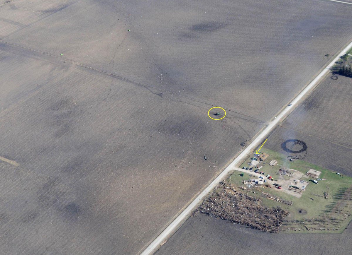
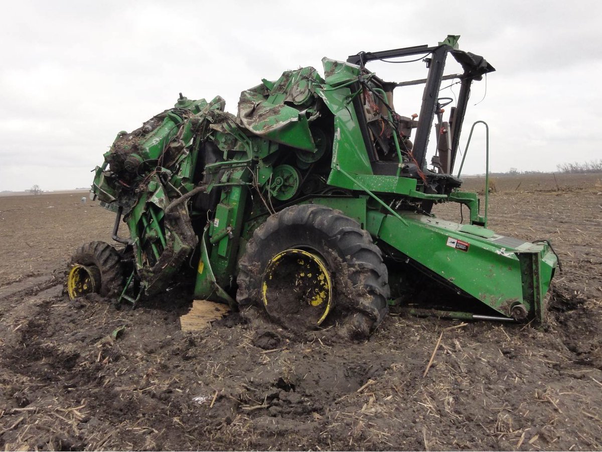
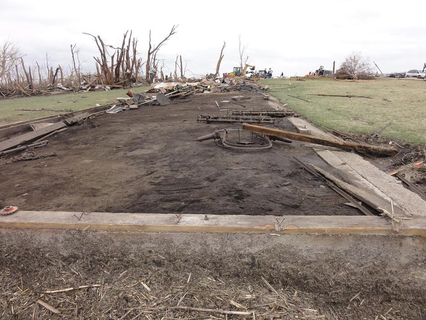
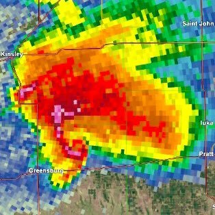
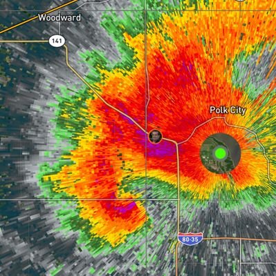
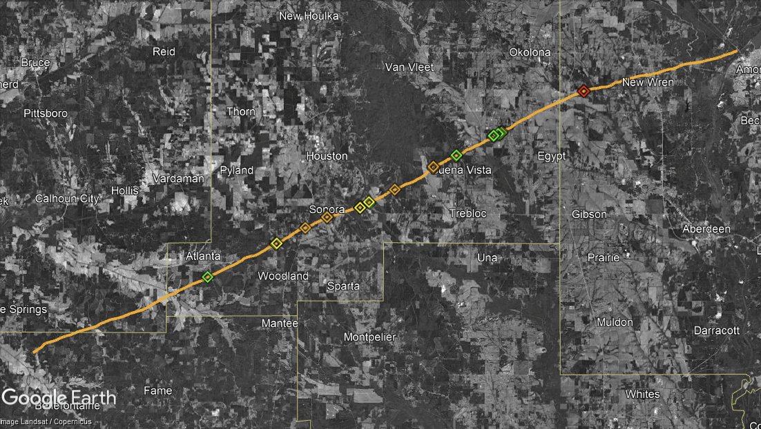
MOB issues Damage Survey PNS (Max: EF1) at Apr 6, 2:32 PM CDT ...NWS Damage Survey for 03/11/2026 Tornado Event Update #1... mesonet.agron.iastate.edu/p.php?pid=2026…

English
0
3
24
2K
Bryce_WX ретвитнул
Nick Krasznavolgyi
Nick Krasznavolgyi@NickKrasz_Wx·
Next up on the reanalysis front 👀 The April 27, 2011 Anchor–Sonora–Okolona–New Wren, Mississippi EF3 tornado.
Nick Krasznavolgyi tweet media
English
5
6
131
4.4K
Bryce_WX ретвитнул
James Spann
James Spann@spann·
ON THIS DATE IN 1936: A tornado outbreak in the Deep South resulted in a total of 454 deaths and $128 million in damage. During the evening of the 5th, a tornado hit Tupelo, MS, killing 216 persons and damaging infant Elvis Presley's neighborhood. The next morning, the paths of two tornadoes met about 8:30 AM and cut a swath four blocks wide through Gainesville, GA, killing 203 persons. At least 70 people died in the Cooper Pants Factory, the greatest tornado toll ever for a single building. In Northwest Alabama a tornado formed from the same storm as the Tupelo F5 and moved through Franklin and Colbert counties. It destroyed or damaged 30 homes in Red Bay, killing four people. Three additional deaths took place in a filling station and a fourth in another home.
James Spann tweet mediaJames Spann tweet mediaJames Spann tweet media
English
1
25
122
8.8K
Bryce_WX ретвитнул
Craig Ceecee, Ph.D.
Craig Ceecee, Ph.D.@CC_StormWatch·
@NWSAtlanta @NWSMorristown While taking a look at the 2011 tornado outbreak, I found a possibly tornadic scar that Google Earth along the GA-TN line near the I-24/59 junction which likely dates to late 2005/early 2006. The orange area seems to be the area. Storm Data has nothing.
Craig Ceecee, Ph.D. tweet media
English
0
1
11
561