Закреплённый твит
FORMATION
140 posts

FORMATION
@FormationApp
FORMATION GmbH makes useful and beautiful digital maps for events, offices and industrial locations #maps #events #offices #industry #berlin #SaaS #Maps #Berlin
Berlin, Germany Присоединился Temmuz 2016
313 Подписки89 Подписчики
FORMATION ретвитнул

Most digital twin investments stall for one reason: They’re not grounded in how the world actually looks today.
Niantic Spatial’s Reconstruction capability fixes this, creating a living, machine-readable 3D model that stays in sync with reality, so every system, team, and workflow operates from the same ground truth.
In a new blog by Trista Pierce, Business Development Lead, explore how Scaniverse’s Reconstruction technology changes the cadence entirely.
Read more: hubs.ly/Q04brNtg0
English
FORMATION ретвитнул

You can now track single or multiple objects in videos completely locally using Sam3 + MLX
Prince Canuma@Prince_Canuma
mlx-vlm v0.4.2 is out 🚀 New models • Sam3 by @facebook (+ realtime mask-only label drawing) • DOTS-MOCR by rednote-hilab Fixes • Qwen3.5 RMSNorm dtype fix • LFM2-VL loads without torch • Magistral image token expansion fix • PaliGemma processor kwarg routing fix • Thinking defaults fixed in CLI + server Shoutout to @pcuenq, and @mdstaff for his first contribution! Get started today: > uv pip install -U mlx-vlm Leave us a star ✨ github.com/Blaizzy/mlx-vl…
English
FORMATION ретвитнул

Visualizing the Strait of Hormuz shutdown using AIS tracking data.
Wild to see the precipitous drop off in transits from 100's of vessels per day to a handful.
The craziest part is zooming in to track a single Indian LPG tanker and watching it intentionally go dark -- turning off its AIS to sneak through the chokepoint, before popping right back on the radar on the other side.
OSINT is too much fun. Pulling this together to a bigger 4D god's eye view of the gulf region.
English
FORMATION ретвитнул

FORMATION ретвитнул

You pick any location on earth and it is turned into a threejs environment within seconds
Holy fuck this could be insane!
Spent 20min on this, imagine if someone actually puts some effort into this
English
FORMATION ретвитнул

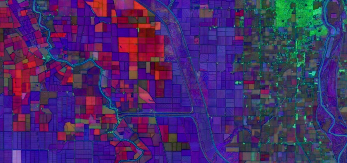
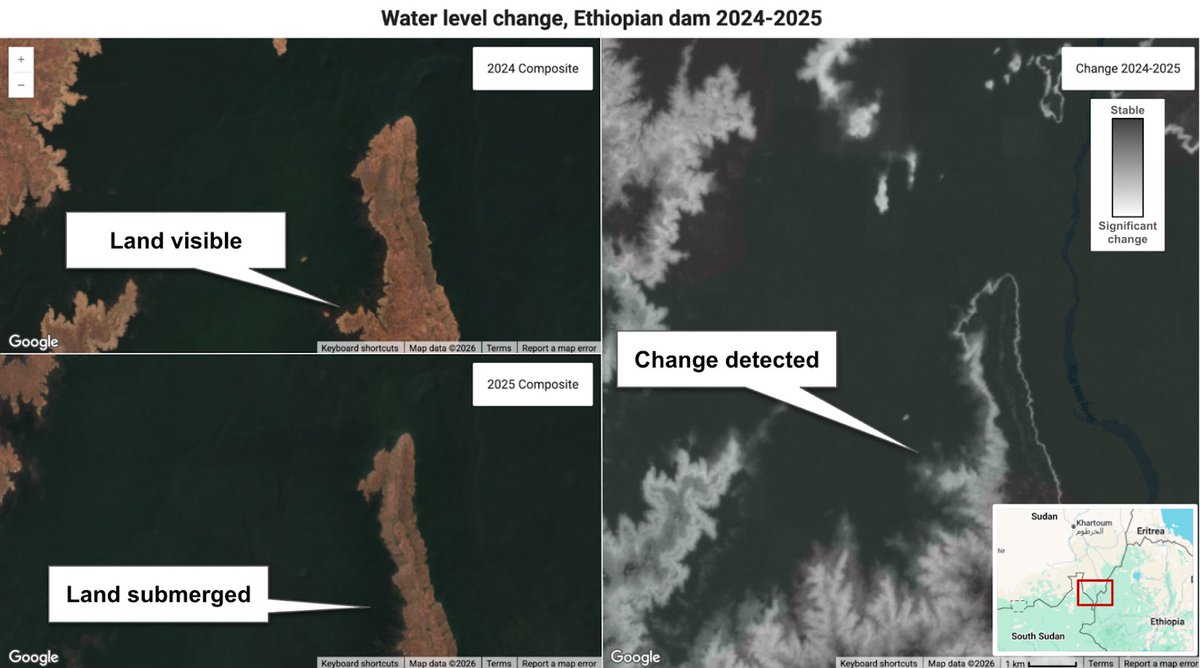
We are thrilled to announce that Google’s Satellite Embedding dataset, powered by @GoogleDeepMind's AlphaEarth Foundations model, has been updated for 2025. This additional year of coverage now unlocks the ability to look back, compare, and detect change across the planet with unprecedented clarity. Learn more here ➡️ goo.gle/3NdIxWn
Part of Google's Earth AI, the new data represents the state of the planet throughout 2025, distilling petabytes of multi-sensor data into a 64-dimensional embedding for every 10 meter pixel.
What’s new in this update? 🧵👇
- 🌍 2025 Data: The state of the planet throughout 2025 is now available on the Earth Engine Data Catalog and Google Cloud Storage.
- 🔬 Unprecedented Change Detection: Because these embeddings capture subtle spectral, spatial and temporal signatures, they make it easy to spot significant year-over-year changes without the heavy lifting of raw image processing.
- 💚 Long-term Commitment: We are formalizing our commitment to the ongoing production of these annual layers to support your operational workflows.
Since we first launched the Satellite Embedding dataset, we’ve been inspired by how our community is putting this data to work. Applications are ranging from ecosystem mapping and agricultural crop-typing to carbon stock prediction. We can’t wait to see what you do next.
#EarthEngine #GeoAI #DeepMind

English
FORMATION ретвитнул

𝗢𝗻𝗲 𝗺𝗲𝗺𝗼𝗿𝘆 𝗰𝗮𝗻’𝘁 𝗿𝘂𝗹𝗲 𝘁𝗵𝗲𝗺 𝗮𝗹𝗹.
We present 𝗟𝗼𝗚𝗲𝗥, a new 𝗵𝘆𝗯𝗿𝗶𝗱 𝗺𝗲𝗺𝗼𝗿𝘆 architecture for long-context geometric reconstruction.
LoGeR enables stable reconstruction over up to 𝟭𝟬𝗸 𝗳𝗿𝗮𝗺𝗲𝘀 / 𝗸𝗶𝗹𝗼𝗺𝗲𝘁𝗲𝗿 𝘀𝗰𝗮𝗹𝗲, with 𝗹𝗶𝗻𝗲𝗮𝗿-𝘁𝗶𝗺𝗲 𝘀𝗰𝗮𝗹𝗶𝗻𝗴 in sequence length, 𝗳𝘂𝗹𝗹𝘆 𝗳𝗲𝗲𝗱𝗳𝗼𝗿𝘄𝗮𝗿𝗱 inference, and 𝗻𝗼 𝗽𝗼𝘀𝘁-𝗼𝗽𝘁𝗶𝗺𝗶𝘇𝗮𝘁𝗶𝗼𝗻.
Yet it matches or surpasses strong optimization-based pipelines. (1/5)
@GoogleDeepMind @Berkeley_AI
English
FORMATION ретвитнул

Experimenting Gaussian Splatting with 360 images! Having omnidirectional views ensures no capture gaps, which makes spatial reconstruction so easy. It’s honestly a blast to see the space come to life.
#GaussianSplatting #3DGS
English
FORMATION ретвитнул

Esri just brought gaussian splatting to the web. ArcGIS Maps SDK 5.0 introduces a native GaussianSplatLayer for SceneView.
Splats now stream directly into browser-based GIS apps.
English
FORMATION ретвитнул

We used Gemini 3.1 Pro to build a realistic city planner app. 🏙️
Watch how the model tackles complex terrain, maps out infrastructure, and simulates traffic to generate a high-quality visualization.
English
FORMATION ретвитнул

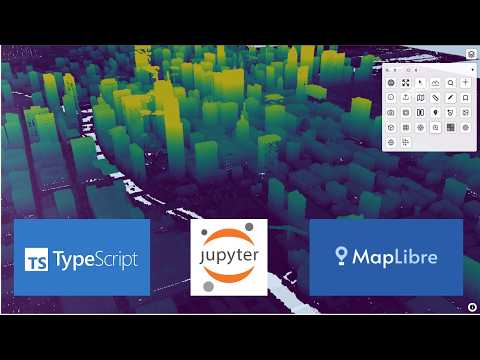
Introducing anymap-ts: a new Python package that makes geospatial visualization easy!
Built on MapLibre + TypeScript, anymap-ts brings the same rich mapping experience to both the web and Jupyter Notebook. It supports many popular geospatial formats, including GeoJSON, GeoParquet, FlatGeobuf, PMTiles, COG, Zarr, COPC LiDAR, and Gaussian Splat.
It also includes powerful built-in UI components such as a minimap, bookmarks, print tool, view state manager, STAC search, street view, and geometry editor.
Try it out:
Web demo: opengeos.org/maplibre-gl-co…
Jupyter demo: notebook.link/github/opengeo…
GitHub: github.com/opengeos/anyma…
Documentation: ts.anymap.dev
Video tutorial: youtu.be/Xr_UfBI46bc
#mapping #maplibre #typescript #jupyter #python
YouTube
English
FORMATION ретвитнул

FORMATION ретвитнул

A critical gap in modern AI isn't language or vision. It's spatial grammar. And it reveals a fundamental data bottleneck.
We built MapTrace, a fully automated, generative AI pipeline (models act as creators/critics) to generate 2M high-quality map-path pairs. The result: Fine-tuning on this synthetic data lowered path-tracing errors and boosted the success rate by +6.4 points for Gemini 2.5 Flash on real-world maps.
English
FORMATION ретвитнул
So these researchers figured out you can basically hallucinate 3D cities into existence using just satellite photos & a diffusion model.
The problem's pretty straightforward: satellites only see rooftops. Building facades? Invisible. Street-level detail? Doesn't exist. But people want flyable 3D environments, which means you need all that occluded geometry.
When I worked on google maps photogrammetry, we could only use satellite-based 3D for isolated stuff like the pyramids - anything city-scale required airplane flyovers. Which is fine until you hit aerial-denied regions where you literally can't fly. Huge chunks of the world just unavailable.
Their trick is honestly kind of beautiful. They train gaussian splats on satellite views, but as it descends toward ground level, the renders turn to absolute garbage - artifacts everywhere. Instead of fighting this, they just treat those nightmare renders as the input to a diffusion model. Basically - "hey FLUX, fix this mess."
Then here's where it gets clever: they generate multiple diffusion samples per view instead of committing to one. Because any single denoising path is probably wrong in 3D space, but if you generate a couple and let the GS optimization find consensus across them, you get actual geometric consistency.
They do this in episodes, curriculum style - start high, gradually descend (hence the name Skyfall-GS!). With each iteration the ground-level views get less fucked. By the end you've got real-time flyable cities that look surprisingly real, and the geometry still matches the satellite input.
No 3D training data. No street-level photos. Just satellites + diffusion doing what it does best - filling in the blanks. It's like neural scene completion but actually practical, and it unlocks basically the entire world.
English
Are you ready for DPP 4.0 and AAS requirements coming from the EU?
If not, check our latest article:
tryformation.com/blog/2025-05-1…
English
FORMATION ретвитнул

We are developing next generation defence technologies and innovation, with more than €1 billion of funding!📢🇪🇺
With the adoption of the European Defence Fund Work Programme for 2025, we:
➡️reduce the fragmentation of investment
➡️strengthen industrial competitiveness
➡️promote interoperability.
Learn more:
europa.eu/!Xtmmw3


English
European Defence Tech: founders, investors, supporters meetup.com/european-defen… #Meetup via @Meetup
#DefenceTech #DefenseTech
English
Defense and resilience tech reached an all-time high 10% of all VC funding in Europe.
techcrunch.com/2025/02/12/def…
English
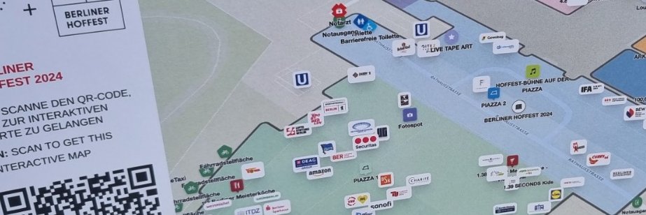
Walking around @Berlin_Asia Summit using the FORMATION Event Map. My own position quite accurately achieved indoors at the amazing Berlin City Hall, thanks to the power of GPS/GNSS alone.
Our Event Map solution does what you need right out of the box!
#Event #Maps #GPS #GNSS
English
FORMATION ретвитнул