Myanmar Map

99 posts

Myanmar Map banner
Myanmar Map

Myanmar Map

@MapsofShady

I make maps in my freetime, if you're interested in worldpolitics, is this the perfect place for you. My new project is the civil war map of Myanmar.
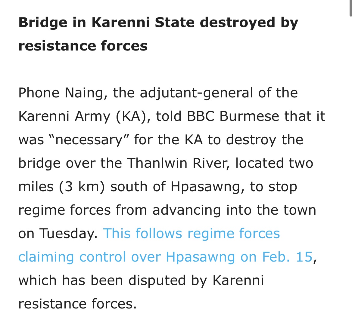
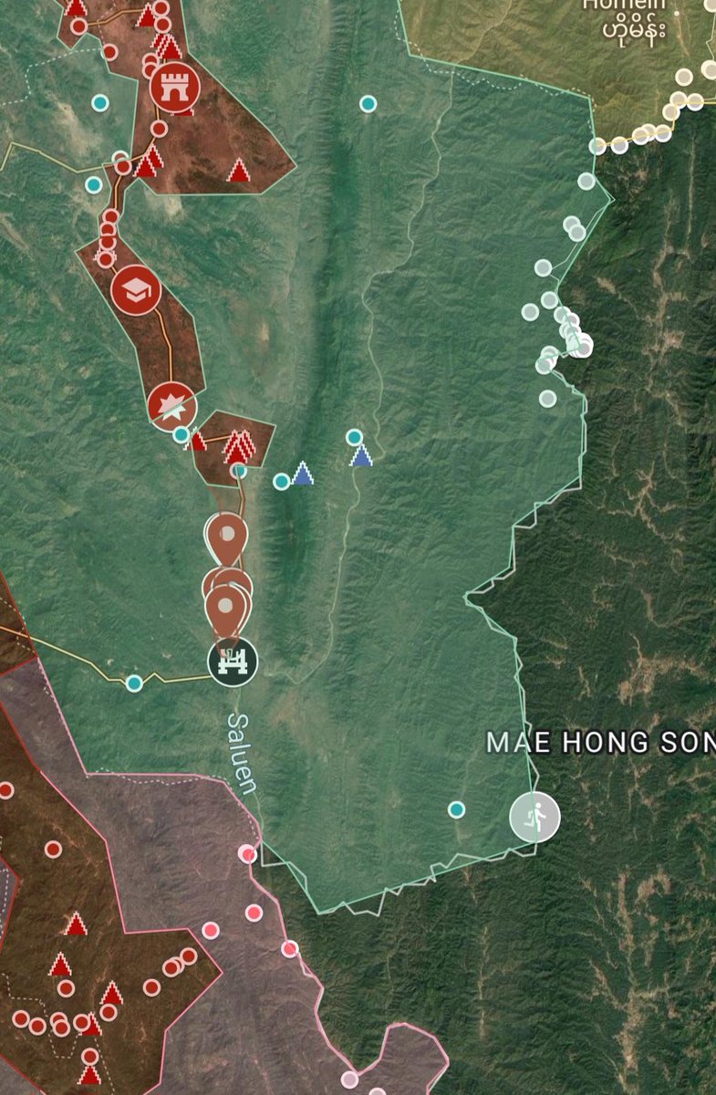
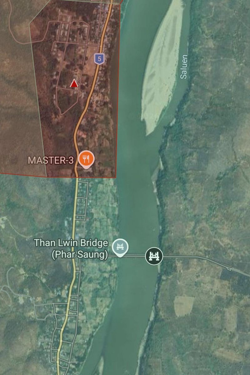
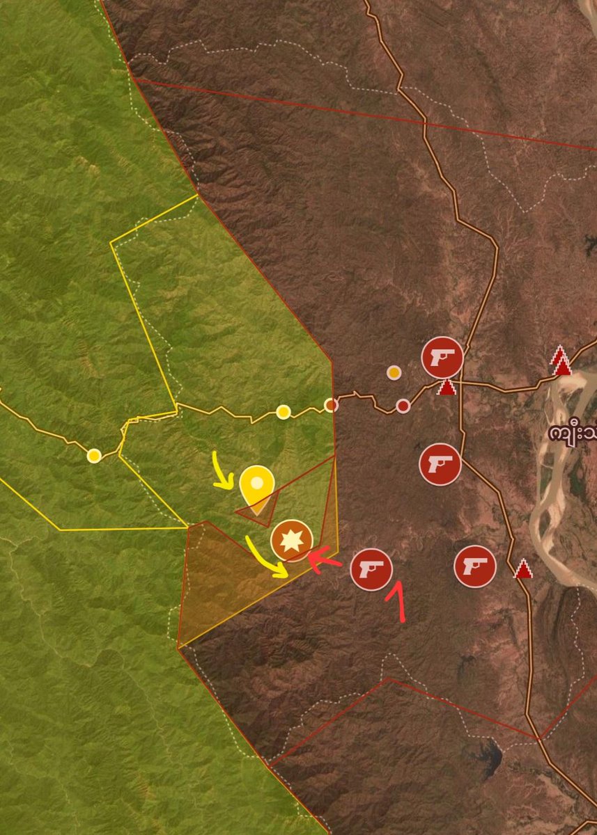
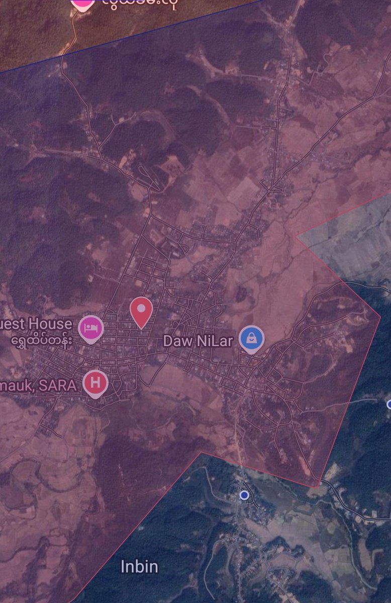
เข้าร่วม Aralık 2025
42 กำลังติดตาม168 ผู้ติดตาม
ทวีตที่ปักหมุด
Myanmar Map
Myanmar Map@MapsofShady·
A Google Map of the Myanmar Civil War, created by @MyanmarWarMap. This is a work in progress I can't guarantee 100% accuracy, but regulary updated. google.com/maps/d/u/2/edi…
English
0
1
11
6.3K
Myanmar Map รีทวีตแล้ว
War Noir
War Noir@war_noir·
#Myanmar (#Burma) 🇲🇲: Chinland Defense Force (#CDF) struck gatherings of Junta soldiers in the city of #Hakhka, #Chin State. CDF fighters used FPV Kamikaze Drones possibly armed with modified 60ER / 81ER MK II mortar bombs.
English
6
26
154
26.7K
Myanmar Map
Myanmar Map@MapsofShady·
#3 The attack was launched from War Bo Island (3). The island has been under #AA control for quite some time. SAC forces retreated after the fall of the bases towards their ROC base and is launching repeated artillery strikes on AA forces in this area.
English
2
1
11
572
Myanmar Map
Myanmar Map@MapsofShady·
#2 Around 200 SAC troops were stationed at each base. This marks a significant blow to SAC forces, as their defenses were breached. With AA forces gaining a foothold on the island in this area, it could potentially lead to the gradual fall of #Sittwe. --->
English
1
1
15
692
Myanmar Map
Myanmar Map@MapsofShady·
#1 In mid-January, #AA forces attacked the regional capital of #Rakhine State. In a small offensive, they captured two bases from #SAC forces. They took one base in Taw Kan village (1) and another near Kant Kaw Kyun village (2). ---> #Myanmar
Myanmar Map tweet mediaMyanmar Map tweet media
English
1
1
21
1.6K
Myanmar Map
Myanmar Map@MapsofShady·
In mid-January, around 80 #SAC soldiers escaped from a #KNDF prison. Most of them crossed the border, reportedly with the prison guards helping them escape. #Myanmar
Myanmar Map tweet media
English
1
2
13
695
Myanmar Map
Myanmar Map@MapsofShady·
#1 The #KNDF destroyed the Than Lwin bridge with a landmine to stop a possible push by #SAC forces towads #Mese town. Questionable is why KNDF forces didn't destoyed the Htoo Chaung bridge (1) further north, this would have slowed down an attack on #Hpasawng, ---> #Myanmar
Myanmar Map tweet mediaMyanmar Map tweet mediaMyanmar Map tweet mediaMyanmar Map tweet media
English
2
3
12
615
Myanmar Map
Myanmar Map@MapsofShady·
#2 and the city would probably still be under their control. A serious mistake, which will cost many resistance lives. Later, the bridge was shelled by artillery, but it only caused minor damage.
English
0
1
8
233
Myanmar Map
Myanmar Map@MapsofShady·
@sheehanj920 One main question is why they didn't blown up the bridge towards Hpa Sung in Htoo Chaung. This would have stopped the SAC assault towards Hpa Sung
English
0
0
4
72
Josh Sheehan 🇲🇲 🪷🌳
Josh Sheehan 🇲🇲 🪷🌳@sheehanj920·
(I wanna add that I personally find it highly commendable for them to “own” the action & feel it should not net them any criticism, since they’re simply reacting to an assault where they have vastly fewer resources)
English
1
1
5
157
Myanmar Map
Myanmar Map@MapsofShady·
In #Hpapun, the #KNU has been attacking the last remaining #SAC bases since the beginning of the year. There are reports that the KNU captured one base but had to withdraw because of counterattacks by the air force. Fighting ongoing #Myanmar
Myanmar Map tweet media
English
0
3
14
668
Myanmar Map
Myanmar Map@MapsofShady·
In #Hpakant #KIA forces captured and destroyed the police station in Hpa Pyin, later withdrew, #SAC troops are now stationed at a nearby school and church (Map corrections towards SAC) #Myanmar
Myanmar Map tweet media
English
0
2
12
630
Myanmar Map
Myanmar Map@MapsofShady·
#2 Two days later, they secured the entire town and the nearby Battalion 134 base (2), with KNDF forces retreating into the countryside. After two years of encirclement and fighting, the only remaining Battalion 135 base has now also been relieved.
English
0
0
7
297
Myanmar Map
Myanmar Map@MapsofShady·
#1 #SAC forces have recaptured the town of #Hpasawng in #Kayah State from #KNDF. At the end of last year, SAC captured the Htoo Chaung Bridge(1) linking Bawlakhe and Hpasawng. From there, they launched a new push last week, capturing the villages of Nant Kit and Pa Pu. #Myanmar
Myanmar Map tweet mediaMyanmar Map tweet media
English
1
0
14
555
Myanmar Map
Myanmar Map@MapsofShady·
@sheehanj920 This has been reported by some outlets. Likely AA have some instructors present in this region to give PDF forces the knowledge of capturing bases. AA forces are also very active in Bhamo this is likely a logical expansion of its forces to divert SAC Troops away from Rakhine
English
1
0
7
196
Josh Sheehan 🇲🇲 🪷🌳
Josh Sheehan 🇲🇲 🪷🌳@sheehanj920·
an article today from DMG (a previously Sittwe-based & very pro-AA outlet) titled "AA military movement extends to Sagaing": facebook.com/dmgnewsagency/… they seem to quote a Rakhine politician who references the "great importance" of Sagaing, including for "the western alliance"...?
Josh Sheehan 🇲🇲 🪷🌳@sheehanj920

Coincidentally, a day or so after KIA's below comments, Myanmar's PLA posted a combat report depicting a "NUG" badged troop... The next day, NUG MoD's Region 1 posted a combat report reporting joint operations alongside AA troops. (& both are reporting from Sagaing)

English
1
1
10
548
Myanmar Map
Myanmar Map@MapsofShady·
#SAC forces attempted to capture the local high ground, but the attacks were repelled by the #KIA. In street fighting, more than 35 SAC troops were killed, six were captured, and a company commander was also killed.
English
0
0
11
398
Myanmar Map
Myanmar Map@MapsofShady·
#SAC forces in Hpakant have launched a new offensive toward Hseng Taung, which is controlled by the #KIA. Heavy fighting is ongoing in Yu Ma village and Ma Shi Ka Thaung Ward, suggesting a KIA presence in these areas (map changes towards KIA). #Myanmar
Myanmar Map tweet media
English
1
2
16
725
Myanmar Map
Myanmar Map@MapsofShady·
#SAC forces have launched a renewed offensive to recapture Min Let Pan from #KNU forces. Heavy fighting is ongoing, and civilians are fleeing after repeated heavy airstrikes in the area. #Myanmar
Myanmar Map tweet media
English
1
3
16
736
Myanmar Map
Myanmar Map@MapsofShady·
This puts KaPaSa 16 in great danger. Point 666 was its largest defensive base. SAC troops are already preparing the defense of the factory.
English
0
0
13
280
Myanmar Map
Myanmar Map@MapsofShady·
At the #Padaung front in #Bago, #AA forces once again captured Point 666 base after a long siege. Around 200–300 #SAC troops had been stationed at the base. AA troops are now within 3 km of KaPaSa 16 (1). SAC forces are already launching counterattacks toward the base. #Myanmar
Myanmar Map tweet media
English
2
0
17
417
Myanmar Map
Myanmar Map@MapsofShady·
In #Banmauk in upper #Sagaing region #SNA forces with asistance from #SAC troops and newest drones regained at first 2/3 of the town but later captured the full town. #PDF forces had to withdraw after 2 months of controll. Half of the town is destroyed from airstrikes. #Myanmar
Myanmar Map tweet mediaMyanmar Map tweet media
English
1
0
17
607