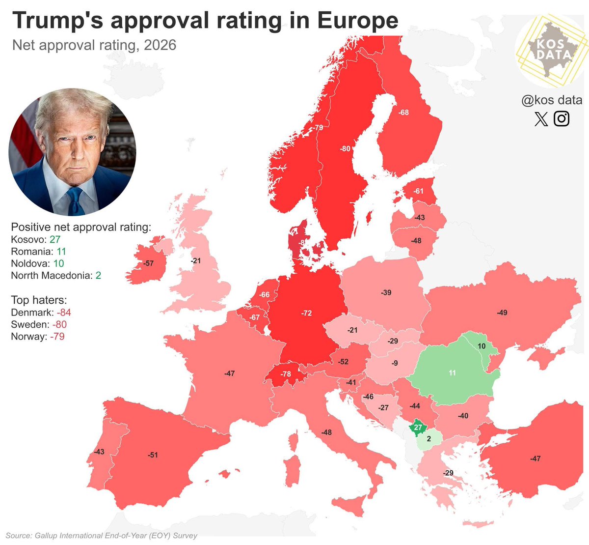
Does all of Europe hate Donald Trump? You could be excused for thinking so, but no.
The American president has a net positive approval rating in four countries: Kosovo (27 points), Romania (11), Moldova (10) and North Macedonia (2).
Why do Kosovans love Trump? Well, maybe it’s not so much the current occupant of the White House, as any occupant of the White House.
Kosovo’s positive view of the U.S. dates back to the 1990s, when U.S.-led NATO bombings on Serbia halted the oppression of the Albanian-majority population in Kosovo, then still ruled by Serbia.
That’s why the Kosovan capital Pristina boasts a Bill Clinton Boulevard (plus an 11-foot-high statue of the former president).
And why is Trump relatively popular in those other three Eastern European countries?
In large part because Trump’s blunt “America First” rhetoric resonates with local opposition against further integration with the European Union, which is seen by many on the right as too liberal, too internationalist; and because the U.S. is considered as an ally, or at least a counterweight, against Russian encroachment.
Those arguments also play out to a lesser extent in Hungary, led by Trump ally Viktor Orban: Trump’s net approval rating may be in the red, but by fewer points (-9) than in any other European country.
If Trump is doing relatively well in Europe, it’s in neighbouring countries like Czechia (-21), Slovakia (-29), Croatia (-27) and Greece (-29). We did say *relatively*.
Oh, but also in the UK, where the U.S. president is under water by only 21 points. Could we put this down to the cultural affinity between Brits and Yanks, or to the growing support for the right-wing Reform Party, led by another Trump ally, Nigel Farage?
Trump is doing very badly in four of Europe’s other Big Five countries: France (-41), Italy (-48), Spain (-51) and especially Germany (-72).
But the U.S. president’s worst scores are in the Nordics, where he gets a net negative approval rating of -79 in Norway, -80 in Sweden, and -84 in Denmark.
The Danes have long been one of the most U.S.-positive countries on the Continent, yet their current hostile attitude comes as no surprise. It’s hard not to be offended when the leader of a supposedly allied nation threatens to take over part of your territory by force.
Just a word of clarification: net approval is positive views minus negative views, ignoring undecided responses. For example, if 45% of Kosovans have a positive view of Trump and 18% disapprove, while 37% don’t have an opinion, that would result in a net approval of 27 points.
Denmark’s extremely lopsided negatives leave less room for undecideds. Let’s say no Dane is undecided on Trump. A net approval of -84 points would require 92% to disapprove of Trump, while 8% approve.
So, even among the Danes, there is a small cohort of Trump fans. Given the circumstances, it is unlikely they go about their day wearing MAGA hats.
Data for this map from the Gallup International End-of-Year Survey. Map seen here on Roman Sheremeta’s X feed: x.com/rshereme/statu…
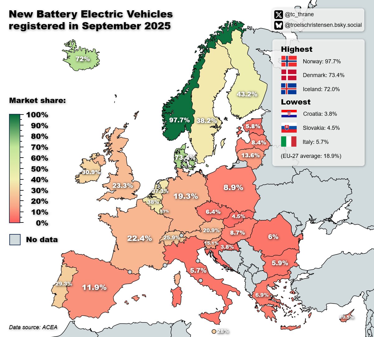
This September, 97.7% of all new cars registered in Norway were battery-electric vehicles (BEVs).
That makes the Norwegians best in class when it comes to adopting full-electric, zero-emission cars - both worldwide, and of course also in Europe.
No other European country is in the same league, and quite a few are doing considerably worse. We’re looking at you, Eastern Europe. Slovenia (15.1%) and Lithuania (13.6%) are the only two markets in that region that manage a BEV registration score higher than 10%.
The lowest score in Europe is for Croatia (3.8%). Italy, one of Europe’s Big Five economies, only slightly improves on that figure (5.7%).
Most of Western Europe is doing better than embarrassing, but worse than great. Germany, France, and the UK, Europe’s three largest economies, are all hovering around 20%. Spain, the fifth of the Big Five, barely breaks 10%. Quite a contrast with its neighbour Portugal, which is close to 30%.
Belgium and the Netherlands are both close to 40%, almost on a par with the slowest Nordic BEV adopters. Third position is for Iceland (72%), second place is for Denmark (73.4%). That’s still almost 25 percentage points behind Norway.
Note that these are new vehicle registrations, which only form a small part of the total vehicle fleet in each market. The average EU car is well over 10 years old, and high prices for new vehicles are constantly pushing up that average.
Consequently, those total markets are electrifying at a much slower rate than the figures on this map would suggest. Some projections put the year in which zero-emission vehicles will outnumber petrol and diesel cars on European roads a full decade after 2035, when the EU is banning the sale of all petrol and diesel cars.
Which means that in 2045, half of all cars on European roads - the older half - will still be powered by petrol or diesel.
Map found here
x.com/tc_thrane/stat…
on Troels Christensen’s X account
x.com/tc_thrane/
“Baseball on valium, with a tea break”: to the non-initiated, that definition of cricket, by the late American comedian Robin Williams, is as useful as it is funny.
For at least it defines the contours of a game, so beloved throughout the British Commonwealth, that to the rest of the world seems to revel in its arcane impenetrability.
That sense of bewilderment was caught perfectly in a five-minute sketch by legendary Dutch comedy outfit Jiskefet (youtube.com/watch?v=E_6d3J…).
Only slightly less hilarious is this map of cricket positions. The sheer density is mind-boggling, as are the names - ‘deep backward square leg’, ’straight long off’, ‘silly point’.
Wait, there’s actually a position called ‘silly point’? The game is up, literally. Cricket’s not real. You’ve been having us on, haven’t you?
Map found here at Terrible Maps:
facebook.com/photo/?fbid=56…
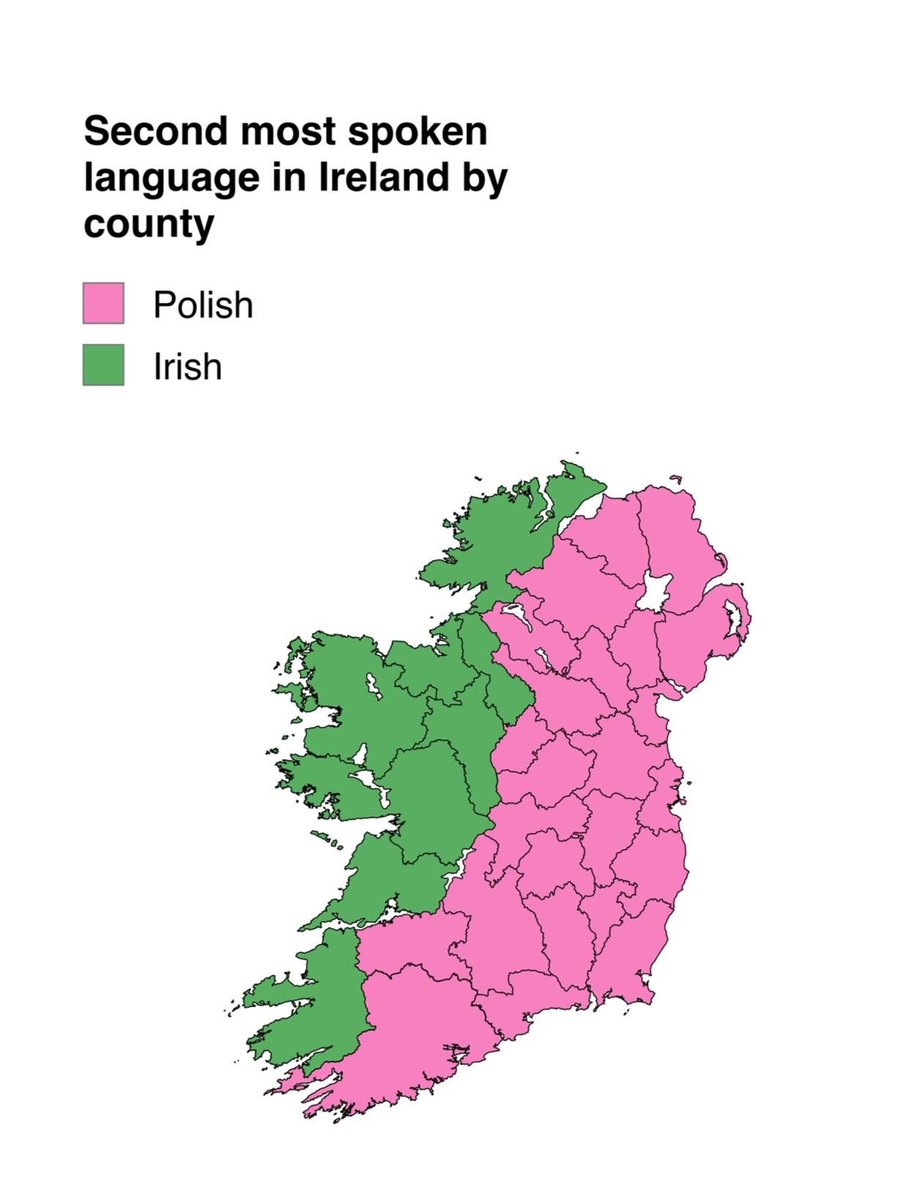
‘Gaeltacht’ is the Irish name for those areas of Ireland where Gaelic, the Irish language, is still the predominant vernacular. As this map indicates, those areas are in the west of Ireland.
The official Gaeltacht is much smaller than the eight counties indicated on this map, which illustrates a slightly different metric: the areas where Irish is the second-most spoken language, after English.
In a much larger part of Ireland, the second-most spoken language after English is… Polish. After centuries of emigration, Ireland in the last few decades has become a country of immigration. That is why there are almost twice as many Polish speakers in Ireland as there are daily Irish speakers (just under 136,000 vs. almost 72,000).
So, what would be the correct Irish name for the pink area in the east - the Polanntacht?
Map via BrilliantMaps
facebook.com/brilliantmaps
“At 761 feet long, (the Pont Neuf) is the longest of Paris’s 35 main bridges (there are 37 in all, if you count the ring road around Paris).”
This map shows all bridges, sans those two outer ones on the Périphérique. All quotes below, as well as the map itself, are from ‘The Seine – The River That Made Paris’ by Elaine Sciolino, an excellent addition to an obscure sub-genre of travel literature, the river biography. (See also: ‘Remonter la Marne’, by Jean-Paul Kauffmann; and ‘Sweet Thames Run Softly’, by Robert Gibbings).
“The Pont Neuf was so revolutionary that Henry IV inaugurated it in 1607 by crossing it on a white stallion. Today, it is still the oldest bridge in Paris, but it was so modern at the time that it was given the name ‘New Bridge’.”
“The Pont de la Concorde, in front of the National Assembly, was built during the French Revolution using stones of the demolished Bastille, ‘so that the people could forever trample on the old fortress’, according to Rodolphe Perronet, the bridge’s engineer.”
“The Pont de la Tournelle (…) is anchored by a 1928 statue of Sainte Geneviève, the patron saint of Paris (…), her hands on the shoulders of a child who represents the city.”
“The double-decker Pont de Bir-Hakeim carries the No. 6 Métro high above the Seine, making it the most visually rewarding Métro trip in Paris.”
“The most elegant of Paris bridges (is) the Pont Alexandre III, a Belle Époque confection (…) built for the Paris Exposition Universelle of 1900, named in honor of the father of the visiting Russian czar, as a symbol of the emerging diplomatic alliance between France and Russia.”
“The newest bridge, a pedestrian span named after the twentieth-century feminist, novelist, and philosopher Simone de Beauvoir, has no pillars or visible sign of support, although it spans one of the widest stretches of the Seine.”
For more, consider buying the book.
wwnorton.com/books/97803936…
Interesting take on the ‘Look how long Chile is’ meme.
The typical comparison rotates Chile 90 degrees (making it look like a skinny version of Cuba) and moves it to where it can be seen to link two improbably distant places. Such as San Francisco and New York, Lisbon and Moscow, or France and Newfoundland.
This map marries displacement with latitudinal accuracy, of a sort.
Here, Chile’s latitudes are simply reversed. For example, the Chilean capital Santiago is 33 degrees south of the Equator, but on this map, it would be at 33 degrees north, exactly the same latitude as Los Angeles, by the way.
All other points in Chile are similarly transposed from the southern to the northern hemisphere, which means that Chile’s entire position is reversed: its actual north is south on this map, and vice versa.
And that is instructive not just of Chile’s geographic extent, but also gives us a rough idea of the country’s climates. Its ‘Canadian’ bits will have very cold winters, while its ‘Mexican’ parts would have a more tropical climate.
Between those two extremes, Central Chile has a moderate, Mediterranean climate, which like California’s is well suited to agriculture.
Map found here on the Twitter/X account of Tim Wallace, map dude at the New York Times.
x.com/wallacetim/sta…
“Every other sentiment’s an antique / as obsolete as warships in the Baltic”, sang Prefab Sprout in the 1980s. Ah, those innocent days.
In recent years, the Baltic Sea has turned into a potential geopolitical flashpoint. With the accession of formerly neutral Sweden and Finland to the North Atlantic Treaty Organisation, it is now effectively a “NATO lake” - with the notable exception of Russia’s two marine outlets in the area, St Petersburg and Kaliningrad.
Since Russia’s invasion of Ukraine in 2022, the Baltic is a major battlefield in the undeclared shadow war between Moscow and the West, with undersea pipelines and cables being cut, and a ragtag fleet of exotically flagged tankers smuggling Russian hydrocarbons out of the country, via the Danish straits. Those may be narrow, but Denmark is prohibited by treaty from limiting, inspecting or taxing maritime traffic through these waterways.
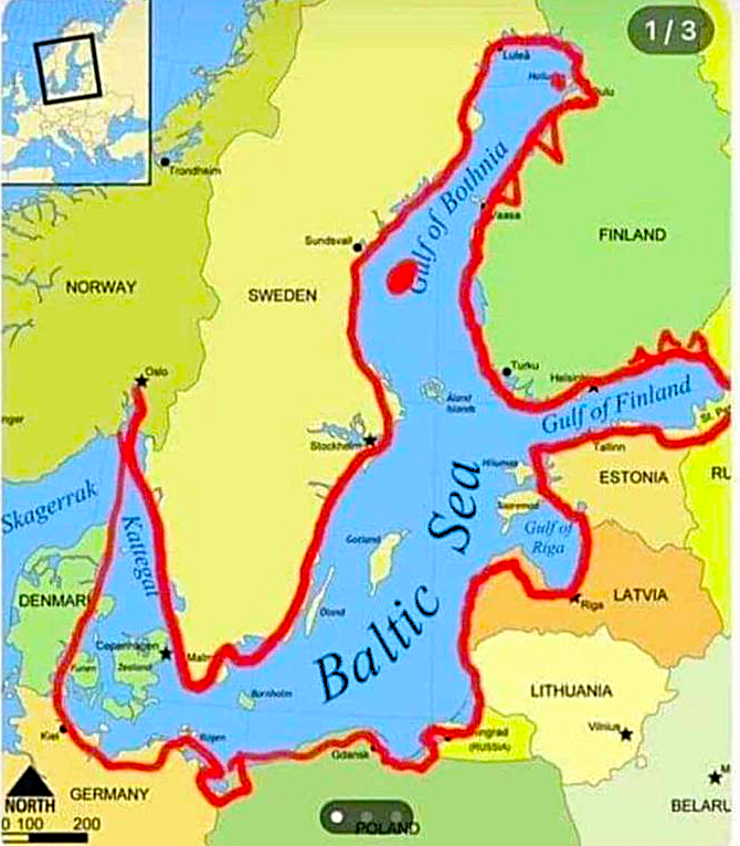
The Baltic needs a new image, one reflective of its more delicate, more dangerous current status. How about this Baltic Crocodile? Once seen, it can’t be unseen. With its tail in Kattegat, its fangs deep into Finland, and its paws impressed in the coasts of Germany and Poland, it exemplifies both the geographic breadth and the geopolitical depth of the Baltic today.
Map via Terrible Maps:
x.com/TerribleMaps