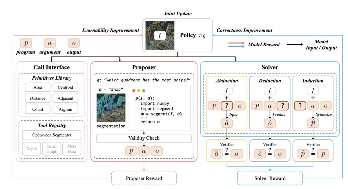
Oryf

526 posts

Oryf banner
Oryf

Oryf

@oryf_geo

Jasa Pemetaan & Analisis GIS | 📧 [email protected] | 📞 https://t.co/0wy1vEJRms

Kota Palu เข้าร่วม Nisan 2024
65 กำลังติดตาม13 ผู้ติดตาม
ทวีตที่ปักหมุด
Oryf
Oryf@oryf_geo·
“Dari satu testimoni ke testimoni lainnya, kami terus berkomitmen memberi hasil terbaik.” Terima kasih untuk semua kepercayaan yang diberikan! Hubungi kami disini jika berminat: wa.me/6281299735603 #zonauang #jasapembuatanpeta #petapenelitian
Oryf tweet media
Indonesia
41
0
0
859
Oryf
Oryf@oryf_geo·
@UpworkSupport My account is restricted ("payment method issue") despite a successful Connects purchase, Good standing, and 0 violations. Chatbot gives no ticket number or timeframe. Been stuck for 3+ days with no human contact. Please help escalate this. 🙏
English
1
0
4
29
Oryf
Oryf@oryf_geo·
@seyirnotlari Dari gambar: 1. 3 Patrick = 36 kg 3P = 36 P = 12 kg 2. 2 Patrick + Squidward = 32 kg 2(12) + Q = 32 24 + Q = 32 Q = 8 kg 3. Squidward + 2 SpongeBob = 50 kg 8 + 2S = 50 2S = 42 S = 21 kg Jadi, berat SpongeBob adalah 21 kg. ✅
Indonesia
1
1
7
1.9K
Seyir.
Seyir.@seyirnotlari·
Sadece pratik zekaya sahip olanlar yapabilecek! Sünger bob'un kilosu nedir?
Seyir. tweet media
Türkçe
80.7K
1.4K
52.4K
16.3M
SHENO WIRANG
SHENO WIRANG@ShenoWirang·
Wah, ini parah ini, sudah nggak bisa ketolong lagi. 𝗡𝗚𝗚𝗔𝗞 𝗔𝗗𝗔 𝗢𝗕𝗔𝗧𝗡𝗬𝗔!
Indonesia
1.1K
1.1K
4.2K
410.4K
Oryf
Oryf@oryf_geo·
Finalisasi layout peta kesehatan mangrove tahun 2026. Dari pengolahan citra satelit, klasifikasi kondisi mangrove, hingga penyusunan layout peta untuk menghasilkan informasi yang siap digunakan dalam analisis dan pelaporan. kontak: wa.me/6281299735603 #zonauang #Mangrove
Oryf tweet media
GIF
Indonesia
0
0
0
257
Yohan
Yohan@yohaniddawela·
A geospatial model trained on zero human-written question-answer pairs just beat models trained on millions of them. The model's called GeoX. It studies satellite and aerial images, invents its own geospatial questions, turns them into executable code, solves them, then uses the code output as its answer key. That sounds odd until you look at what geospatial reasoning actually requires. Most vision models can answer simple image questions. Is there a building? How many cars are visible? Is this a forest, a port, or a residential area? Real geospatial work asks a harder class of question. Which building is closest to the road? Which quadrant contains the largest ship? Is the land-use area larger than the building area? Which object is nearest to the parking lot? Those are spatial problems. They depend on area, distance, adjacency, overlap, count, centroid, direction and relative position. Ultimately, the problem is scale. A single urban satellite image can contain hundreds of buildings, vehicles, roads, trees, fields, rivers and industrial sites. For each object, you can ask about its size, neighbours, distance, overlap, direction and relation to every other object. The question space explodes faster than humans can label it. That’s the gap GeoX tries to solve. Instead of relying on people to write endless training examples, it makes the image generate part of its own supervision. The model plays two roles. First, it acts as a proposer. It creates a spatial problem over the image and expresses it as a small program. Then it acts as a solver. It tries to answer the problem from the image. A verifier runs the program and checks whether the answer is right. Take a harbour image. GeoX can segment the ships, select the largest one by area, calculate its centroid, then return whether that centroid lies in the top-left, top-right, bottom-left or bottom-right quadrant. The answer comes from executing the program. A human label isn’t needed. That gives the model a clean training signal: if its answer matches the program output, it’s correct. If it misses, it gets penalised. This is valuable because geospatial reasoning has a property many vision tasks lack. A lot of the answer can be checked through geometry. Area can be computed. Distance can be computed. Overlap can be computed. The nearest object can be computed. A quadrant can be computed. GeoX uses that structure to train itself. The authors make it learn through three modes. Deduction: given the image, program and input, predict the output. Abduction: given the image, program and output, infer the input that would have produced it. Induction: given examples of inputs and outputs, reconstruct the program behind them. In practical terms, the model learns to reason forwards, reason backwards, and infer the rule. The proposer also has an incentive to create useful problems. If a problem is too easy, the solver learns little. If it’s impossible, the solver learns little. The reward is highest when the solver gets it right around half the time. That creates an automatic curriculum. GeoX starts with simple problems such as checking whether a building exists. Over time, it moves towards harder combinations: comparing areas, counting objects, locating centroids, finding nearest objects and combining multiple spatial relations in one question. The results are pretty strong. GeoX improves its base vision-language models by up to 5.5 points on average. The current version is still limited. It mainly uses an open-vocabulary segmenter plus spatial tools such as area, centroid, distance, count and quadrant. It doesn’t yet handle elevation, slope, road-network connectivity, reachability, or external metadata such as OpenStreetMap attributes. Anyway, I think a geospatial model writing its own spatial exam, marking it with executable geometry, and improving from the result feels like a meaningful shift in how remote sensing AI gets trained. I’d be interested to see this tested next on disaster damage assessment, urban accessibility, or road-network reasoning.
Yohan tweet media
English
3
11
57
3.6K
Oryf
Oryf@oryf_geo·
@giswqs waah keren pak
Indonesia
0
0
0
91
Qiusheng Wu
Qiusheng Wu@giswqs·
GeoLibre v0.5.0 is out! This update significantly expands data format support, making it easier to work with a wide range of geospatial datasets in a lightweight, modern GIS environment. Newly supported formats and services include: GeoJSON, Shapefile, GeoPackage, GeoParquet, KML/KMZ, FlatGeobuf, PMTiles MBTiles, GeoTIFF, Zarr, LiDAR point clouds, Gaussian Splatting, and ArcGIS services. GeoLibre is a lightweight, cloud-native GIS built with MapLibre and Tauri. It runs directly in the browser and is also available as a standalone cross-platform desktop application at only ~30 MB. GitHub: github.com/opengeos/GeoLi… Website: geolibre.app Live demo: geolibre.app/demo Feedback, ideas, and contributions are welcome. #geospatial #opensource #maplibre
English
4
65
360
18.9K
Oryf
Oryf@oryf_geo·
Analisis kondisi mangrove berbasis citra satelit untuk memetakan area mangrove sehat, sedang, dan rusak. GIS dan penginderaan jauh memungkinkan monitoring mangrove dilakukan lebih cepat dan efisien pada wilayah yang luas. Hubungi kami: wa.me/6281299735603 #zonauang
Oryf tweet media
Indonesia
0
0
0
164
Oryf
Oryf@oryf_geo·
Selamat pagi all, ad bisa ngerjain peta ndvi? #zonauang
Indonesia
0
0
0
56
Oryf
Oryf@oryf_geo·
Selamat siang all, ad yg bisa ngerjain peta kerentanan banjir gk?
Indonesia
0
0
0
45
Oryf
Oryf@oryf_geo·
joki analisis bahaya erosi menggunakan metode USLE #zonauang
Indonesia
20
0
2
2.5K
Oryf
Oryf@oryf_geo·
joki analisis bahaya erosi #zonauang
Indonesia
29
0
6
1.1K
Oryf
Oryf@oryf_geo·
need joki laporan geografi #zonauang
Lietuvių
39
0
9
4.3K
Oryf
Oryf@oryf_geo·
need joki peta administrasi #zonauang
Indonesia
14
0
4
4.4K
Oryf
Oryf@oryf_geo·
need joki peta kebencanaan banjir #zonaauang
Indonesia
5
0
2
2.8K
Oryf
Oryf@oryf_geo·
need joki peta RTRW #zonaauang
Indonesia
5
0
2
681
Oryf
Oryf@oryf_geo·
Need joki peta tutupan lahan #zonauang
Indonesia
17
0
1
1.2K
Oryf
Oryf@oryf_geo·
Oryf tweet media
ZXX
0
0
0
31